Europe North Down (1501)
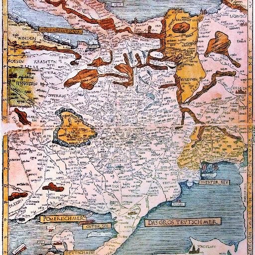
This is Erhard Etzlaub's second printed European roadmap from 1501, the so-called Landstrassen map. It is very similar to Etzlaub's earlier Romweg map, which was the first ever printed european roadmap.<br> Photo by User:Neitram taken in 2008 in the Mercateum in Königsbrunn, Germany.<br> (From <a href="http://commons.wikimedia.org/wiki/File:Etzlaub_Romwegkarte_5.jpg">Wikimedia Commons</a>)
All spots information
10 spots
 Europe

Photo: Venice and its Lagoon Type:culturalInscription:1987Country:Italy

Photo: Ponte Vecchio Type:culturalInscription:1982Country:Italy
Photo: Sagrada Familia Type:culturalInscription:1984,2005Country:SpainPlace:Sagrada Familia

Photo: St. Vitus Cathedral Type:culturalInscription:1992Country:Czech Republic
Photo: Swiss Alps Aletsch Type:naturalInscription:2001/2007Country:Switzerland
Photo: Landscapes of Rhaetian Railway Type:culturalInscription:2008Country:Switzerland,Italy

Photo: Costiera Amalfitana Type:culturalInscription:1997Country:Italy
Photo: Palace of Versailles Type:culturalInscription:1979/2007Country:France
Photo: Cologne Cathedral Type:culturalInscription:1996,2008Country:Germany
【the WH】Vatican City
![]() Europe
Europe
Photo: Piazza San Pietro Type:culturalInscription:1984Country:Vatican City