Philadelphia (1802)
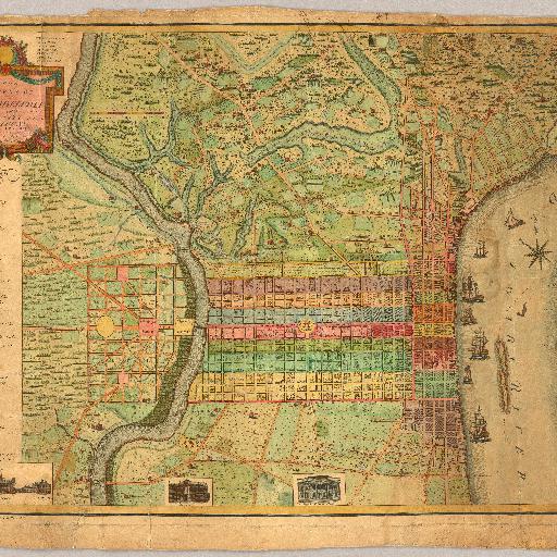
<html> <body>A beautiful, early map of Philadelphia in full period color. The scale is given at 75 Perches to 1 inch. The city is shown from the Delaware River to the Schuylkil River with the environs on the north and south. 24 lettered references and 28 numbered references to important places and buildings are below the title and 24 wards are keyed in Roman numbers above the title. Many of the country houses and farms around the city are named, including Penn, Dr. Wistar, and other notable early residents. Three inset views show City Hall, the State House, Court House, Library, and Bank of the United States. The tile is surrounded by a decorative cartouche. The quality of the engraving is superb. Ristow mentions an undated edition that was possibly issued in the year Varle made the surveys, 1796, but more likely in 1802. Wheat and Brun list a c.1794 State I that has one less numbered building reference, no Roman numbered ward references, and "R. Scott Sculp. Philadelphia." This was Varle's first map published in the United States. Until 1807, Varle was known as Peter C. Varle; after 1807 he is known as Charles P. Varle.</body> </html>
All spots information
0 spots