Osaka, The mock painted picture of the great Osaka (1924)
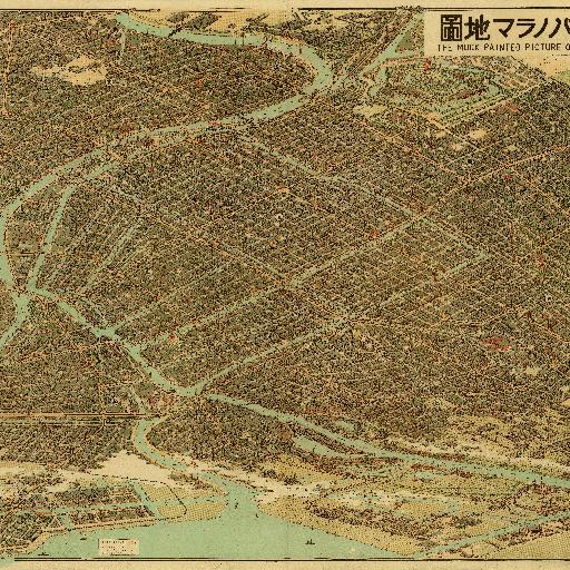
大正12年12月28日印刷、大正13年1月5日発行
All spots information
30 spots
 Osaka
Osaka
新梅田シティ 空中庭園展望台
![]() Osaka
Osaka

空中庭園展望台(梅田スカイビル) 1993 年に完成した高さ約173m の高層ビル。その独特の形状により、大阪の人気観光名所の一つ。「Dorling Kindersley」が選ぶ「TOP 20BUILDINGS AROUND THE WORLD」の一つ。アテネのパルテノン神殿、バルセロナのサグラダ・ファミリアといった歴史的建造物と共に選出された世界的にも有名な建築物。空中庭園展望台には、「空中庭園大明神」を祀る社があり御利益は恋愛成就。ここからの夕景は「日本の夕陽百選」にも選ばれています。 「中自然の森」(なかしぜんのもり) 空中庭園(梅田スカイビル)の南側には、自然の中に飛び込んでしまったような風景が広がります。
大阪駅(大阪ステーションシティ)
![]() Osaka
Osaka
2011 年に大阪駅再開発により生まれ変わりました。プラットホーム中央部を覆う東西長約180m、南北長約100m の大屋根は圧巻。三越伊勢丹、ルクアが完成、大丸の拡張で西日本最大、日本第2 位の規模を誇る商業施設となりました。映画館、8つの広場、屋上には農園があります。
明治24年(1891年)、大阪市で初めて誕生した公園です。堂島川と土佐掘川にはさまれた延長約1.5km、面積10.6haの緑あふれる都心のオアシス。国の重要文化財の大阪市中央公会堂、府立中之島図書館などの重厚な建築物もあります。
2012年12月、水都大阪に電気で走る観光船「あまのかわ」が誕生しました。1時間の充電で6時間の運行が可能、音が静かで、排気ガスが出さない環境にやさしい先進的な船です。今回は、水都大阪のシンボル空間「中之島」をゆったりお楽しみください。
八軒家の由来は江戸時代にさかぼのります。当時、京都と大坂を結ぶ淀川舟運の要衝として栄え、この辺りには八軒の船宿などが軒を並べていた事からそうと呼ばれました。勝海舟や坂本龍馬も利用していました。2008年、往時の八軒家浜の賑わいを水都大阪の再生の拠点とするため、八軒家浜船着場が開港しました。
大阪の祭 堀川戎神社「十日戎」
![]() Osaka
Osaka

堀川戎神社は、約1400 年以上もの昔、欽明天皇の時代(539~571)に蛭子大神(えびすのおおかみ)を主神に祀られた由緒あるお宮です。浪速年中行事随一の「十日戎(とおかえびす)」は、関西一円の人々から「えべっさん」と親しまれ、江戸時代中期から「ミナミの今宮、キタの堀川」と並び称せられ、その盛大さは今もなお衰えることなく、毎年1 月9 日・10 日・11 日の「十日戎宝の市神事」には、商売繁昌を願う参詣者数十万人が参拝されます。
創建は949年、主祭神は学問の神様、菅原道真公。1000年以上続く「天神祭」は日本三大祭のひとつで、そのクライマッ クスをかざる船御渡は壮大な火と水の祭です。また、戦後途絶えていた十日戎が、2007年「天満天神えびす祭」として復活しました。
「住まいの歴史と文化」をテーマとした日本初の専門ミュージアムです。9階「なにわ町家の繁盛記」は、江戸時代のフロア。当時の大坂の町並みを実物大で再現。8階「モダン大阪パノラマ遊覧」は、明治、大正、昭和のフロアで近代の大阪の住まいと暮らしを模型で展示しています。
南北約2.6kmと直線では日本一の長さを誇る「天神橋筋商店街」。約600店のお店が連なり、その規模、距離感は圧巻です。歴史あるお店から、最新の専門店、大阪の味が楽しめる飲食店まで満載、東西にも大小の商店街、横丁があり、それぞれ独特の雰囲気をかもし出しています。本日は予定コース(約1.6km)を歩くと「満歩状」(商店街をすべて歩いた証明書)を差し上げます。
Osaka
This photo shows at "Sennichimae". ("Rakutenchi" is the right of the photo) In one of the temples in this neighborhood the monks chanted to Buddha for one thousand days. In result, this area became known as “Sennichimae” which means "the front of One-Thousand-Days-Temple” Near the ruins of a fire in 1912, opened a complex of cinema, theater, roller-skate park and an observatory called "Rakutenchi", which made this a place of entertainment. The photo shows at "Rakutenchi" observatory.

This photo was taken between 1885 and 1890. "Shitennouzi temple” was built in the late 6th century.This temple is said to have been the first Buddhist temple in Japan.
Midosuji Street
![]() Osaka
Osaka
"Mido-suji", The current Osaka city's main street used to be only six meters wide at the time.
The photo shows Osaka Business Park now. Until the end of World War II the current Osaka Business Park was the site of “Imperial Arsenal Works Osaka”.Here, the cannon was made.
Osaka Castle
![]() Osaka
Osaka
The main tower of the osaka castle being rebuilt about 1930. Osaka Castle, the symbol of Osaka.The main tower of the castle was burnt down in the 17th Century.By the donations of the citizens, the main tower of the castle was rebuilt in 1931.
Nakanoshima
![]() Osaka
Osaka
This photo was taken at "Nakanoshima" in 1930's. "Nakanoshima" was the economic, political and cultural center in Osaka.
Minamiokajima
![]() Osaka
Osaka
Minamiokajima used to be a rural area.Today, This place is a residential and industrial area.
The site of a spinning factory became a park. Some parts of the factory walls still remain in the park.
The photo shows the Tempozan peaks of today. "Tenpozan Mountain" 's elevation is 4.53m. This is the lowest altitude of the mountains in Japan.This is an artificial mountain built in the 19th Century. Pine and cherry trees were planted there and it was a very popular place for cherry-blossom viewing and boating.
This Photo was taken at "Tsutenkaku" and "Shinsekai" "Tsutenkaku" is the name of the tower which was created in 1912. It was shaped like a combination of the Arc de Triomphe and the Eiffel Tower."Tsutenkaku" was demolished in 1943 during World War II to supply the weapon industry with its iron."New Tsutenkaku" was rebuilt in 1956.
Dotonbori Canal
![]() Osaka
Osaka
This photo was taken in 1951 This map shows the Kabuki and puppet theaters.Currently the theaters are closed except for one. The area has become a quarter of food and beverage.
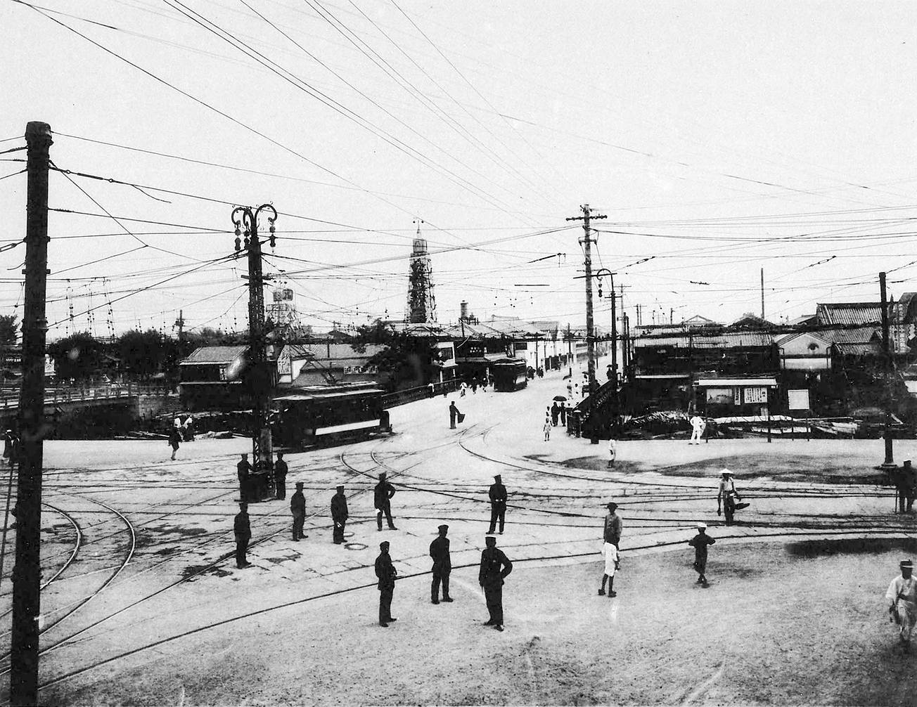
Namba Station
![]() Osaka
Osaka
Namba Station of Hankai-Railway (Present Nankai electric railway) in 1889. Namba Station (Nankai Terminal Building in 1932)
This station building in the photo was built in 1901.It was rebuilt in 1940. Osaka Station is the gateway station in Osaka.
Imperial palaces of the seventh and eighth century were excavated in 1957. The site has been mainteined as a historic site park. At the time of the map, this place was the site of the Japanese Army.
now Osaka Dome
![]() Osaka
Osaka
A baseball ground "Osaka Dome" was founded in 1997.At the time of the map, there was a gas company's plant.