旧町名マップ
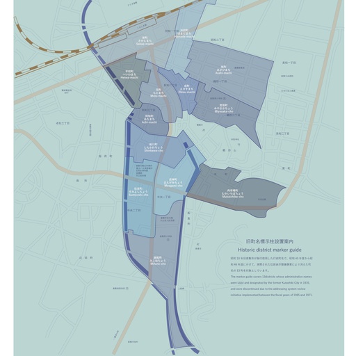
昭和10年旧倉敷市が施行使用した行政町名で、昭和40年度から昭和46年度にかけて、実際された住居表示整備事業により消えた町名の13町を対象としています。
 Posted by浦辺設計更新日:
 すべてのスポット情報
13件のスポット
 石標
石標

日本語 English 設置位置:中央2丁目2番 中央図書館北 由来文:天和3年(1683年)に新田用水と倉敷川を東西に結ぶ水路が新しく造られ、新川と呼ばれたところから、この水路のほぼ南側一帯が新川町と呼ばれた。昭和46年12月に廃止された。 Location:2-Chome 2 Chuo, north of Kurashiki Chuo Library Name origin:In 1683, a new waterway was built to connect the Shinden-yosui irrigation channel with Kurashiki-gawa River from east to west. The new waterway was named Shinkawa, leading to the area to the south being designated Shinkawa-cho. The name was discontinued in 1971. -->

日本語 English 設置位置:鶴形2丁目7番 鶴形2丁目公園 由来文:鶴形山の北麓から北西一帯の区域。“山の後”と呼ばれた鶴形山北麓一帯や倉敷尋常高等小学校(現・倉敷東小学校)があった旭町の一部が一つになって、昭和10年に宮坂町となった。昭和42年9月に廃止された。 Location:2-Chome 7 Tsurugata, 2-Chome Tsurugata Park Name origin:Corresponds to the area stretching northwest from the northern foot of Mt. Tsurugata-yama. In 1935, Miyasaka-cho was formed from part of Asahi-machi (the location of Kurashiki Jinjo Higher Elementary School, now Kurashiki Higashi Elementary School) and the northern foot of Tsurugata-yama (called Yamanoato). The name was discontinued in September 1967. -->

日本語 English 設置位置:阿知2丁目12番 倉敷えびす通り 由来文:鶴形山の西、ほぼ現在のえびす通り商店街の区域。江戸中期には夷(戎)町の町名が見られ、また、浜村(現・浜町付近)に通じる道があることから浜之通りとも呼ばれた。明治時代以降は、商店街として発展していった。昭和42年9月に廃止された。 Location:2-Chome 12 Achi, Kurashiki Ebisu-dori Name origin:Corresponds to the area west of Mt. Tsurugata-yama, comprising most of what is today the Ebisu-dori shopping district. Named Ebisu-machi during the middle of the Edo period, the area was also referred to as Hamano-dori for having a road to Hama-mura (now in the vicinity of Hama-machi). The area developed into a shopping district since the Meiji period. The name was discontinued in September 1967. -->

日本語 English 設置位置:鶴形1丁目7番 倉敷郵便局西 由来文:倉敷センター街の東から倉敷中央病院の手前までのほぼ現在の鶴形1丁目の区域。かつては県立高等女学校(現・倉敷青陵高校の前身)や税務署が、昭和7年に倉敷市庁舎が現在の倉敷郵便局の敷地に置かれていた。昭和42年9月に廃止された。 Location:1-Chome 7 Tsurugata, west of Kurashiki Post Office Name origin:Corresponds to the area comprising what is today 1-Chome Tsurugata, east from Kurashiki Center Street to the front of Kurashiki Central Hospital. In the past, a prefectural girls’ high school (the predecessor of what is now the Okayama Prefectural Kurashiki Seiryo Senior High School) and the tax office stood here, and in 1932 Kurashiki City Hall stood on what is today the premises of the Kurashiki Post Office. The name was discontinued in September 1967. -->
日本語 English 設置位置:阿知2丁目2番 倉敷中央通り 由来文:JR倉敷駅前一帯の区域。大正9年にこの町名となった。駅前には運送会社や倉庫、旅館が立ち並んでいたが、次第に飲食店や土産屋が増え、映画館もでき賑わった。昭和42年9月に廃止された。 Location:2-Chome 2 Achi, Kurashiki Chuo-dori Name origin:Corresponds to the area in front of Kurashiki Station. The name was established in 1920. Shipping companies, storehouses, and inns lined these streets, but with time, restaurants and souvenir shops increased in number, and a movie theater was added to the lively mix. The name was discontinued in September 1967. -->
日本語 English 設置位置:阿知2丁目19番 倉敷中央通り 由来文:国道429号の南、倉敷中央通りの両側に広がる区域。 明治時代には新町と呼ばれたが、昭和時代に入ってからは元町筋といわれて親しまれ、昭和10年にこの町名となった。昭和42年9月に廃止された。 Location:2-Chome 19 Achi, Kurashiki Chuo-dori Name origin:Corresponds to the area extending across both sides of Kurashiki Chuo-dori Street, south of Route 429. Although called Shin-cho/-machi in the Meiji period, the area began to be affectionately referred to as Motomachi-suji in the Showa period until the designation became official in 1935. It was discontinued in September 1967. -->
日本語 English 設置位置:阿知3丁目21番31号 大橋家住宅前 由来文:本通り商店街から西に折れて倉敷用水にいたる道の両側に広がる区域。江戸時代初期には井上町と呼ばれたが、宝永7年(1710年)の絵図では阿知町となっている。阿知という地名は、阿知使主(あちのおみ)が率いた渡来人の一族が居住した地にちなむとする説がある。旅館・銀行・各種商店などが並び、商店街の中心のひとつとして発展した。昭和42年9月に廃止された。 Location:3-Chome 21-31 Achi, in front of Ohashi House Name origin:An area that folds west from the Hondori shopping street and extends to both sides of the road leading to Kurashiki Aqueduct. It was called Inoue-cho in the early Edo period, but it is Achi-cho in the picture of Hoei 7 (1710). There is a theory that the place name Achi is named after the place where the family of migrants led by Achi no omi lived. It has developed as one of the centers of the shopping district, with inns, banks, and various shops lined up. -->
日本語 English 設置位置:中央2丁目6番 市立美術館東 由来文:自然史博物館から岡山大学資源生物科学研究所あたりまでの倉敷中央通りの西側の細長い区域。町内には大正期に大原農業研究所や倉敷天文台が、昭和35年に倉敷市庁舎(現・倉敷市立美術館)が置かれた。昭和46年12月に廃止された。 Location:2-Chome 6 Chuo, east of Kurashiki City Art Museum Name origin:Corresponds to the long, narrow area west of the Kurashiki Chuo-dori Street, from the Kurashiki Museum of Natural History to the Okayama University Institute of Plant Science and Resources. The Ohara Institute for Agricultural Research and Kurashiki Observatory were established in the area in the Taisho period, and Kurashiki City Hall was sited here in 1960 (where the Kurashiki City Art Museum is currently located). The name was discontinued in December 1971. -->
日本語 English 設置位置:中央1丁目27番 入船橋親水広場 由来文:倉敷川の新前神橋から入船橋の下流までの西岸に沿った細長い区域。昭和9年には現在地に船だまり(倉敷港)が設けられ、舟運の拠点にもなった。昭和46年12月に廃止された。 Location:1-Chome 27 Chuo, Irifune-bashi Riverside Park Name origin:Corresponds to a long, narrow area along the west riverbank of Kurashiki-gawa River, from the Shinmaegami-bashi Bridge to the waters downstream of Irifune-bashi Bridge. A small dock (Kurashiki-ko) was installed in 1934, making the area a base for water transport. The name was discontinued in December 1971. -->
日本語 English 設置位置:中央1丁目6番 倉敷中央通り 由来文:今橋から新前神橋付近までの倉敷川西岸の区域。天保12年(1841年)には、村会所が置かれるなど、昭和7年まで倉敷の政治の中心地であった。昭和46年12月に廃止された。 Location:1-Chome 6 Chuo, Kurashiki Chuo-dori Name origin:Corresponds to the area on the west riverbank of Kurashiki-gawa River, from Imabashi Bridge to the vicinity of Shinmaegami-bashi Bridge. The village assembly office was established here in 1841 and remained the political heart of Kurashiki until 1932. The name was discontinued in December 1971. -->
日本語 English 設置位置:阿知2丁目16番 倉敷センター街通り 由来文:JR山陽本線寿町踏切から国道429号をへて、倉敷センター街一帯の区域。浜村(現・浜町付近)に通じる道があり、浜の道・浜之通りとも呼ばれていたことから、この町名が付けられた。昭和42年9月に廃止された。 Location:2-Chome 16 Achi, Kurashiki Center Street Name origin:Corresponds to the area around and including Kurashiki Center Street, approached via Route 429 from the JR Sanyo Line crossing in Kotobuki-cho. The area earned its name from the road leading to Hama-mura (now in the vicinity of Hama-machi) and also called Hamano-michi and Hamano-dori. The name was discontinued in September 1967. -->
日本語 English 設置位置:阿知3丁目12番 川西橋北詰め 由来文:おおむね一番街、国道429号及び新田用水に囲まれた三角形の区域。昭和10年に町名を倉敷としたが、同13年に平和町と改めた。一番街は映画館の名にちなんで「千秋座通り」とも呼ばれて親しまれた。昭和42年9月に廃止された。 Location:3-Chome 12 Achi, north of Kawanishi-hashi Name origin:Corresponds to the triangular area surrounded by the shopping district Ichiban-gai, Route 429, and the Shinden-yosui irrigation channel. The neighborhood was named Kurashiki in 1935 but was renamed Heiwamachi in 1938. Ichiban-gai was also known affectionately as Senshuza-dori Street, after the movie theater there. The name Heiwa-machi was discontinued in September 1967. -->
日本語 English 設置位置:本町17番 白壁通り(市民会館) 由来文:倉敷川の東岸で、白壁通りの北側に広がる区域。青物市の立つ本町に向き合って魚介類の市が立っていたところから、向市場町と呼ばれた。現在の倉敷アイビースクエア内には、江戸時代中期に倉敷代官の陣屋が、明治中期に紡績工場が置かれた。昭和42年9月に廃止された。 Location:17 Hon-machi, Shirakabe-dori (Kurashiki City Auditorium) Name origin:Corresponds to the area on the east riverbank of Kurashiki-gawa River that extends north of Shirakabe-dori Street. Mukai means facing, and the former Mukaiichiba-cho owed its name to the seafood market that once stood here and faced the produce market in Hon-machi. In the area that is today Kurashiki Ivy Square, a base was established for the local magistrate in the mid-Edo period and a spinning factory in the mid-Meiji period. The name was discontinued in September 1967. -->