[Beta] The Open Data Institute Data Access Map
![[Beta] The Open Data Institute Data Access Map](https://stroly.com/media/thumbnails/1563975134_512.jpg)
When it comes to sharing or increasing access to data, there is a wide range of different approaches out there and finding the most suitable approach can be tricky. We’ve created the Data Access Map to help people and organisations explore the various options and navigate this difficult terrain. From APIs and blockchains to competitions and data trusts, there are many different approaches that people can take to sharing or increasing access to data. So many, in fact, that it can be difficult to understand the full range of approaches or weigh the benefits and limitations of each. This in turn can make it difficult for us – as data holders, users, researchers, regulators and policymakers – to identify which approach best suits our needs. At the ODI, we’ve embarked on a journey to research, map and describe the various data access approaches out there in the hope that we can help people and organisations to navigate this vast landscape. While some of that work has focused on particular approaches, such as data trusts and open data, we have the wider goal of helping people and organisations understand, compare and adopt the right approach for them. We know we can’t do this alone so we are keen to know what other people think of the map and how we can improve it to make it an accessible, accurate, clear and useful tool for others. If you have time, feel free to share your thoughts by completing our feedback form: https://docs.google.com/forms/d/e/1FAIpQLSdz2vxxit5d0xOyg_Tigx9dH3WQJpTHxCxU-hUipa6xlfl7lw/viewform
All spots information
18 spots
 Landmass
Landmass: Collabrador
![]() Landmass
Landmass
The ODI Data Access Map - Collabrador Landmass: Collabrador Bringing organisations and people together to collaborate around a shared component of data infrastructure The large, central landmass known as Collabrador contains approaches to increasing access that focus on bringing people or organisations together to collaborate around data. Depending on which of the three regions within Collabrador you visit, the shared component of data infrastructure involved will differ. It might be the technical infrastructure used to store or combine a number of datasets (Poole), the institutions put in place to establish various forms of stewardship of data (Governors Island), or infrastructure designed to generate profit (Cheddar Plc). Some of the approaches found here on Collabrador seek to invent or create new components of data infrastructure, while others aim to adapt components that already exist. Context: Much of the conversation about data today centres on the value of data and the benefits of collaborating to tackle shared problems. In recognition of this, Collabrador occupies a central position within the Data Access Map. Caveats and clarifications: Collabrador is not the only landmass that contains approaches that can be used to facilitate collaboration; many other regions on the map are also concerned with collaboration in one way or another, and other approaches can be used to bring people or organisations together. However, in our opinion, the approaches contained within Collabrador are similar enough to warrant their own grouping. Important related or neighbouring regions The Shared Biome The approaches found on the Shared Biome are similar to those found on Collabrador in that they are also aimed at facilitating collaboration amongst diverse parties. However, whereas the approaches on Collabrador are aimed at bringing people and organisations together around a shared component of data infrastructure, the approaches on the Shared Biome are aimed at facilitating collaboration across ecosystems. The difference is subtle, but important. We have placed the two regions in close proximity in recognition of these similarities. Take me to The Shared Biome... The Isle of Human While the approaches on Governors Island can be used to steward a wide variety of types of data (eg data about people or datasets with no personally identifiable information), the last few years have seen an increasing emphasis on identifying and developing new, trustworthy ways of stewarding data about people. To highlight this trend, we created the Isle of Human as a place to collect the wide range of approaches that are explicitly aimed at increasing access to data about people. Take me to The Isle of Human... ODI resources Jeni Tennison (2019), ‘New institutions are needed for the digital age’, https://www.ft.com/content/5f46f102-6741-11e9-b809-6f0d2f5705f6 Additional resources GovLab (2018 and ongoing), ‘Data Collaboratives’, http://datacollaboratives.org/ Nesta (2019), ‘The new ecosystem of trust’, https://www.nesta.org.uk/blog/new-ecosystem-trust/ The British Academy and the Royal Society (2017), ‘Data management and use: Governance in the 21st century’, https://royalsociety.org/topics-policy/projects/data-governance/ Royal Academy of Engineering (2019), ‘Towards trusted data sharing: guidance and case studies’, http://reports.raeng.org.uk/datasharing/cover/ Feedback and comments We want to continue our journey with the map in collaboration with others. If you are a data holder looking for guidance on the various data access options available to you, if you have thoughts on how to improve the map, or if you’d like to get involved in our work, get in touch by emailing research@theodi.org or, fill out our online form (recommended for mobile). Alternatively, we invite you to fill out the online form embedded below Loading… Open Data Institute, 65 Clifton Street, London EC2A 4JE
 Region
The ODI Data Access Map - Poole Region: The Independent Isle Facilitating collaboration through arms-length decision making and governance Situated just off the coast of Governors Island, the Independent Isle contains approaches that encourage, facilitate or establish means of governing access to data independently (or sometimes semi-independently) from the data holder. The approaches found on the Independent Isle delegate decisions around access to data to a small body or group - for instance, empowering a panel to judge applications for access to a store of patient data. Often, the approaches found here are aimed at providing a specific group of people with the explicit remit and responsibility for controlling access to data. These approaches can be used by organisations alongside approaches elsewhere on the Data Access Map and often make up one aspect of the institutional and collaborative approaches to governing access found on Governors Island. Context: Decisions about who should be allowed access to data and for what purpose are often opaque - even to those the data is about or those who may have some rights over the data. The approaches on the Independent Isle are, in part, an attempt to aid transparency in decision making around data access and ensure that we are able to get the most out of data while protecting people against any harmful impacts. Caveats and clarifications: Depending on how they are used, the approaches on the Independent Isle may offer less independence than it appears at first glance. Since they can be used within or alongside a data holder’s existing governance processes, the approaches found here may not satisfy those who are interested in ensuring greater separation between a holder of data and those who have been empowered to make decisions about that data. Approaches Data Review Boards Approvals Panels Delegated Decision-Makers Data Access Boards Important related or neighbouring regions Governors Island Take me to Governors Island... Like the approaches on its southern neighbour, the approaches found on the Independent Isle are an attempt to address the question of who should get to make decisions about data, namely who is allowed access to data, for what purposes and in what circumstances. However, unlike the approaches on Governors Island, which often involve the creation of - and delegation of authority to - institutions or collective enterprises, the approaches on the Independent Isle can more easily be used within or alongside a data holder's or data steward’s existing governance structures. Feedback and comments We want to continue our journey with the map in collaboration with others. If you are a data holder looking for guidance on the various data access options available to you, if you have thoughts on how to improve the map, or if you’d like to get involved in our work, get in touch by emailing research@theodi.org or, fill out our online form (recommended for mobile). Alternatively, we invite you to fill out the online form embedded below Loading… Open Data Institute, 65 Clifton Street, London EC2A 4JE
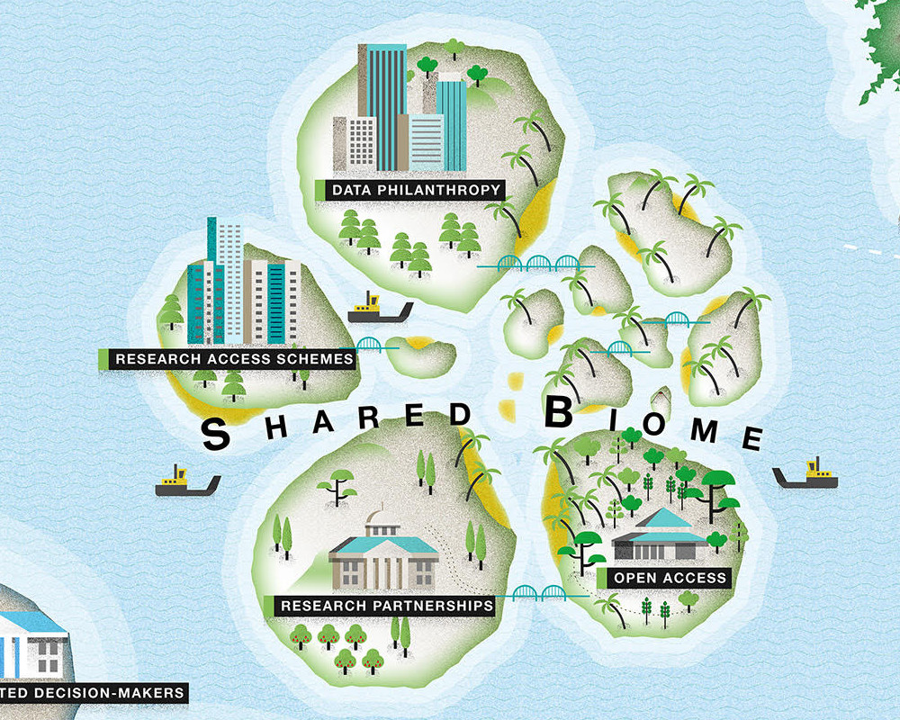
The ODI Data Access Map - The Shared Biome Region: The Shared Biome Currently Under Construction: Check Back Soon Approaches Research Access Schemes Data Sharing Ecosystems Research Partnerships Data Philanthropy Feedback and comments We want to continue our journey with the map in collaboration with others. If you are a data holder looking for guidance on the various data access options available to you, if you have thoughts on how to improve the map, or if you’d like to get involved in our work, get in touch by emailing research@theodi.org or, fill out our online form (recommended for mobile). Alternatively, we invite you to fill out the online form embedded below Loading… Open Data Institute, 65 Clifton Street, London EC2A 4JE
The ODI Data Access Map - The forbidden Isle Region: The Forbidden Isle Limiting or preventing external access to data The large southwestern region known as the Forbidden Isle is unique in the Data Access Map, as it is the only region which is home to approaches that are aimed at limiting or preventing - as opposed to increasing - access to data beyond the current data holder. Things like access control, encrypted storage and password protection aim to safeguard data that we at the ODI describe as residing in the ‘closed’ part of the Data Spectrum. This data might be closed for commercial confidentiality, to protect people’s privacy or to enhance national security. Most of the data that exists in the world is currently siloed within organisations, but not all the data currently held on the Forbidden Isle is there for good reasons. The region houses some data that is currently being siloed within organisations unnecessarily - in some cases because siloing data has long been an organisation’s standard operating procedure, in other cases because organisations are unaware of the ways they can increase access to data safely, ethically and responsibly. Some of the data currently held within organisations could be moved to the ‘shared’ parts of the spectrum while other data could be published openly. In either case, increasing access to that data would enable it to be used in more situations, to address more problems and support more services, thereby unlocking more value from data. The Data Access Map helps organisations explore and identify the approaches that could enable them to safely, ethically and responsibly increase access to the data they hold. Approaches Access Control Encrypted Storage Password Protection Important related or neighbouring regions The Side Steppes Take me to The Side Steppes... Pirate Cove Take me to Pirate Cove... Feedback and comments We want to continue our journey with the map in collaboration with others. If you are a data holder looking for guidance on the various data access options available to you, if you have thoughts on how to improve the map, or if you’d like to get involved in our work, get in touch by emailing research@theodi.org or, fill out our online form (recommended for mobile). Alternatively, we invite you to fill out the online form embedded below Loading… Open Data Institute, 65 Clifton Street, London EC2A 4JE
Region: Pirate Cove
![]() Region
Region
The ODI Data Access Map - Pirate Cove Region: Pirate Cove Extralegal means of gaining access to closed data This semi-hidden lagoon, carved out of the northern reaches of the Forbidden Isle, harbours approaches that aim to breach protections offered in its southern neighbour. As its name would suggest, the approaches found in Pirate Cove aim to make it possible for people or organisations to illegally access data that the current data holder or steward wants to keep restricted. The approaches found on this region share similarities with the approaches found on the Side Steppes as they both aim to provide the means of gaining access to data currently siloed within the Forbidden Isle. In contrast with the Side Steppes, however, the approaches residing in Pirate Cove are decidedly less than legal. DISCLAIMER: We at the ODI would like to note that the inclusion of Pirate Cove on the Data Access Map is not intended as a validation or recommendation of any unlawful activities - only a recognition that such activities happen, and happen often. Approaches Hacking Theft Important related or neighbouring regions The Forbidden Isle Take me to The Forbidden Isle... The Side Steppes Take me to The Side Steppes... Feedback and comments We want to continue our journey with the map in collaboration with others. If you are a data holder looking for guidance on the various data access options available to you, if you have thoughts on how to improve the map, or if you’d like to get involved in our work, get in touch by emailing research@theodi.org or, fill out our online form (recommended for mobile). Alternatively, we invite you to fill out the online form embedded below Loading… Open Data Institute, 65 Clifton Street, London EC2A 4JE
The ODI Data Access Map - The Pretender Isles Region: The Pretender Isles Increasing access while safeguarding sensitive information The Pretender Isles appeal to people and organisations interested in gaining valuable insights from data without exposing sensitive personal information or valuable intellectual property. The approaches for increasing access found here are aimed at creating and utilising datasets that contain some of the qualities of the original data, so that people and organisations can test new products, services and tools with limited risks. The approaches can be implemented by an organisation to facilitate responsible innovation, both internally and externally, while limiting the possibility that the data being used will include sensitive information. Approaches Synthetic Data Test Data Sandboxes Feedback and comments We want to continue our journey with the map in collaboration with others. If you are a data holder looking for guidance on the various data access options available to you, if you have thoughts on how to improve the map, or if you’d like to get involved in our work, get in touch by emailing research@theodi.org or, fill out our online form (recommended for mobile). Alternatively, we invite you to fill out the online form embedded below Loading… Open Data Institute, 65 Clifton Street, London EC2A 4JE
The ODI Data Access Map - The Side Steppes Region: The Side Steppes Legitimate means of gaining access to closed data This small but popular region contains approaches that aim to provide people or organisations with ways of gaining access to data that the current data holder or steward would otherwise designate off-limits. Perched on the eastern edge of the Forbidden Isle, the approaches found here appeal to people and organisations that believe they have a legitimate right to access data currently siloed within the Forbidden Isle. Some of the approaches found here, such as Freedom of Information (FOI) requests or regulatory actions, aim to compel the original data holder to increase access. Other approaches, such as scraping, are often the basis for legal battles as they happen without clear legal authority and aim to provide access by circumventing the interests of the original data holder. Context: Some data held by companies is completely protected, and only accessible through clearly unlawful means - namely hacking (see ‘Pirate Cove’). However, when data is made available through the web, the technological protections against its harvesting are limited. Twitter feeds, LinkedIn profiles, supermarket stocks, cinema listings and so on, are all published for anyone to view with a web browser. Even personal pages that have been made private can be accessed if people can be persuaded to provide their passwords, meaning they can be accessed automatically - a process known as scraping. Frequently, the terms and conditions of websites aim to put legal restrictions in place to prevent programmatic access, but these are variably enforced; organisations sometimes even have a tacit expectation that scraping will happen. And so those who rely on scraping to access data occupy a grey zone of semi-legitimacy, reliant on non-enforcement of T&Cs and subject to the vagaries of website redesigns to keep their scripts working. Approaches Freedom of Information Requests Regulatory Access Scraping Compulsory Publication Important related or neighbouring regions The Forbidden Isle Take me to The Forbidden Isle... Pirate Cove Take me to Pirate Cove... Feedback and comments We want to continue our journey with the map in collaboration with others. If you are a data holder looking for guidance on the various data access options available to you, if you have thoughts on how to improve the map, or if you’d like to get involved in our work, get in touch by emailing research@theodi.org or, fill out our online form (recommended for mobile). Alternatively, we invite you to fill out the online form embedded below Loading… Open Data Institute, 65 Clifton Street, London EC2A 4JE
Region: Poole
![]() Region
Region
The ODI Data Access Map - Poole Region: Poole Collaboration around combined or aggregated datasets The westernmost region of Collabrador, Poole contains approaches to increasing access that are intended to facilitate collaboration by providing the technical infrastructure necessary to store or combine datasets from multiple sources. Some of the approaches found here are designed to make it easier for potential collaborators to discover and access relevant datasets. Other approaches found on Poole are designed to make it possible for people or organisations to draw deeper insights from the analysis of aggregated datasets. Context: The approaches found throughout the Data Access Map are, in one way or another, aimed at making data easier to discover, access and use. The approaches on Poole tend to see technology as the most important factor in making that possible. Caveats and clarifications: Some of the approaches found on Poole do not involve the pooling of actual datasets. Rather, they involve what could be called the pooling of metadata or descriptions of available datasets in order to increase discoverability, with the actual data residing elsewhere - often on the servers of the original data holder. If, based on that metadata or description, a person would like to gain access to the actual data, they are generally directed to the original data holder’s own website or platform where they can arrange access with the original data holder directly. There are a number of benefits to pooling data and a number of valuable services would not be possible without the aggregation of data. Taken to their extreme, however, the publishing models found on Poole have the potential to lead to centralised data ecosystems that are often not as resilient, sustainable or scalable as more decentralised data ecosystems. Approaches Data Repositories Data Platforms Data Labs Data Spaces Data Pooling Data Hubs Data Portals Important related or neighbouring regions Technicaledonia Whether pooling datasets themselves or metadata about those datasets, the approaches on Poole rely on technical infrastructure to store or combine data from multiple sources. That being the case, there are clear connections between the approaches on Poole and the technical mechanisms for sharing and increasing access found on Technicaledonia. Take me to Technicaledonia... OD Island The approaches and technical infrastructure found on Poole can be used to make data available under a variety of open licenses and can support a wide range of business models. For more on open data, visit OD Island. Take me to OD Island... Cheddar Plc. Just as the approaches and technical infrastructure found on Poole can be used to make data available under open licenses, they can be used to generate revenue by bringing together supply and demand for data. For more, visit Cheddar Plc.. Take me to Cheddar Plc. ... Governors Island Implementing the approaches on Poole requires more than identifying and deploying the right technology. People or organisations pursuing these more technical approaches will need to answer questions related to things like governance, data management, oversight, auditing, incentives, privacy, ethics, or public and stakeholder engagement. The approaches on Governors Island can help to steward and govern access to pooled or aggregated datasets. Although the approaches on Governors Island can be used to steward aggregated or pooled datasets, they need not be; a data trust, for instance, can just as easily be used to steward and govern access to a single dataset contributed by a single data holder, as it can be to steward a dataset that combines data from multiple holders. Take me to Governors Island... Feedback and comments We want to continue our journey with the map in collaboration with others. If you are a data holder looking for guidance on the various data access options available to you, if you have thoughts on how to improve the map, or if you’d like to get involved in our work, get in touch by emailing research@theodi.org or, fill out our online form (recommended for mobile). Alternatively, we invite you to fill out the online form embedded below Loading… Open Data Institute, 65 Clifton Street, London EC2A 4JE
The ODI Data Access Map - The Isle of Human Region: The Isle of Human Helping people exercise their rights over data about them The array of approaches found on this serendipitously-shaped eastern isle is one of the most diverse on the Data Access Map. Whereas approaches on other regions have been clustered based on their particular style of governance (Governors Island) or technical infrastructure (Poole; Technicaledonia), the approaches on The Isle of Human have been clustered based on their focus on stewarding or increasing access to a particular type of data: data about people. The approaches found here appeal to data stewards, data reusers and data subjects alike - virtually any person or organisation interested in identifying approaches that can help people better exercise their rights over data about them. Context: When it comes to the stewardship of data, business as usual is not working and sensitive, personal information is often not stewarded in trustworthy ways that ensure privacy. Recent years have seen an increasing emphasis on identifying and developing new, trustworthy ways of stewarding data about people. The Isle of Human is an indication of the widespread and wide-ranging nature of these attempts. Caveats and clarifications: The approaches on The Isle of Human are not the only approaches that can be used to steward data about people. Data trusts (Governors Island) or differential privacy (Technicaledonia) can, if desired, be deployed to steward or increase access to data about people. But the approaches on The Isle of Human are aimed specifically and explicitly at stewarding data about people. Some of the approaches found here are structurally or functionally similar to approaches on other regions. Personal Information Management Systems (PIMS), for instance, are often deployed to help a person generate revenue from providing access to data about them. As such, PIMS share a number of similarities with their not-so-distant revenue-generating relatives on Cheddar Plc. (eg data marketplaces), but are differentiated here based on their explicit focus on data about people. Approaches Data Portability Initiatives Personal Data Lockers Personal Data Representatives Individual Data Donation Personal Information Management Systems (PIMS) Personal Data Stores Important related or neighbouring regions Cheddar Plc. Take me to Cheddar Plc. ... Feedback and comments We want to continue our journey with the map in collaboration with others. If you are a data holder looking for guidance on the various data access options available to you, if you have thoughts on how to improve the map, or if you’d like to get involved in our work, get in touch by emailing research@theodi.org or, fill out our online form (recommended for mobile). Alternatively, we invite you to fill out the online form embedded below Loading… Open Data Institute, 65 Clifton Street, London EC2A 4JE
The ODI Data Access Map - Governors Island Region: Governors Island Facilitating collaboration through the use of institutions that govern or steward data One of three regions within the central Collabrador landmass, Governors Island contains approaches to data access that are, in one way or another, designed to bring people or organisations together by encouraging, facilitating or establishing institutions that can govern or steward data for a given purpose. Some of the approaches found here seek to steward data through shared or collective decision making; others through delegating control over data to a decision-making body entrusted to steward that data. They are all attempts to address the important question of who gets to contribute to decisions around data - including who is allowed access to data, for what purposes, in what circumstances, with what controls, and to whose benefit. Context: When it comes to the stewardship of data, business as usual is not working. We need new approaches in order to get the most out of data while protecting against harms. Most of the approaches contained on Governors Island are attempts to address this reality. Approaches Data Trusts Data Commons Data Cooperatives Data Clubs Important related or neighbouring regions The Independent Isle: Like the approaches found on the Independent Isle to the north, the approaches on Governors Island strive to facilitate means of governing access to data. However, whereas the approaches on the Independent Isle can more easily be used within or alongside a data holder's or data steward’s existing internal governance structures, the approaches on Governors Island often involve the creation of - and delegation of authority to - an external decision-making or stewarding institution. Take me to The Independent Isle... Poole: The approaches on Governors Island can be, and often are, deployed to steward aggregated or pooled datasets, but they need not be: a data trust, for instance, could be used to steward and govern access to a single dataset contributed by a single data holder just as well as it could be to steward a dataset that combines data from multiple holders. Take me to Poole... The Shared Biome Take me to The Shared Biome... Cheddar Plc.: Take me to Cheddar Plc. ... Related resources Nesta (2019), ‘The new ecosystem of trust: How data trusts, collaboratives and coops can help govern data for the maximum public benefit’, https://www.nesta.org.uk/blog/new-ecosystem-trust/ Feedback and comments We want to continue our journey with the map in collaboration with others. If you are a data holder looking for guidance on the various data access options available to you, if you have thoughts on how to improve the map, or if you’d like to get involved in our work, get in touch by emailing research@theodi.org or, fill out our online form (recommended for mobile). Alternatively, we invite you to fill out the online form embedded below Loading… Open Data Institute, 65 Clifton Street, London EC2A 4JE
Region: The Ts&Cs
![]() Region
Region
The ODI Data Access Map - The Ts&Cs Region: The Ts&Cs The fine print This small, almost inscrutable group of islands located midway between the Forbidden Isle and Technicaledonia contains approaches that aim to secure access to data based on consent, permission or legal agreement. By agreeing to the terms and conditions of a service, app, operating system, piece of software or written contract users can provide that service or app or operating system with access to data about them. Sometimes - depending on how the user agreement or contract is written - by clicking 'agree' users can (perhaps unknowingly) provide access to other parties beyond the direct service provider. Call me Ishmael. Some years ago - never mind how long precisely - having little or no money in my purse, and nothing particular to interest me on shore, I thought I would sail about a little and see the watery part of the world. It is a way I have of driving off the spleen and regulating the circulation. Whenever I find myself growing grim about the mouth; whenever it is a damp, drizzly November in my soul; whenever I find myself involuntarily pausing before coffin warehouses, and bringing up the rear of every funeral I meet; and especially whenever my hypos get such an upper hand of me, that it requires a strong moral principle to prevent me from deliberately stepping into the street, and methodically knocking people's hats off - then, I account it high time to get to sea as soon as I can. This is my substitute for pistol and ball. With a philosophical flourish Cato throws himself upon his sword; I quietly take to the ship. There is nothing surprising in this. If they but knew it, almost all men in their degree, some time or other, cherish very nearly the same feelings towards the ocean with me. Approaches User Agreements Contracts Service Integration Feedback and comments We want to continue our journey with the map in collaboration with others. If you are a data holder looking for guidance on the various data access options available to you, if you have thoughts on how to improve the map, or if you’d like to get involved in our work, get in touch by emailing research@theodi.org or, fill out our online form (recommended for mobile). Alternatively, we invite you to fill out the online form embedded below Loading… Open Data Institute, 65 Clifton Street, London EC2A 4JE
The ODI Data Access Map - Technicaledonia Region: Technicaledonia Technical means of sharing or increasing access to data This large, western isle contains approaches to increasing access that are primarily technical in nature. Some of the approaches found on Technicaledonia are geared toward increasing access to data for use by developers and data scientists; others are geared toward enabling analyses to be run on datasets in a way that safeguards privacy. Another group of approaches found here are geared toward visualising datasets in order to make the insights or trends contained within those datasets easier to discern. Depending on the reason for your visit, the approaches on Technicaledonia can also be differentiated based on the roles they play within a data access arrangement - eg collection, storage, curation, processing, management, analysis, visualisation, publication or some combination thereof. Context: Data is becoming more abundant every day, thanks in part to advances in technology. For instance, technological advancements have made it possible for commercial organisations to collect and analyse geospatial data at a scale previously reserved for national mapping agencies. Adopting the approaches on Technicaledonia requires more than identifying and implementing the right technology, however: people or organisations pursuing these more technical approaches will need to answer questions related to things like governance, data management, oversight, auditing, incentives, privacy, ethics or public and stakeholder engagement. Approaches Interactive Reporting Dashboards Public Data Visualisations Data Observatories Intelligence Products Collaboration Tools APIs Data Cubes Data Warehouses Sneakernet Bulk Data Transfer Privacy Enhacing Technologies Data Lakes Developer Platforms Important related or neighbouring regions Poole Take me to Poole... The Pretender Isles Take me to The Pretender Isles... Feedback and comments We want to continue our journey with the map in collaboration with others. If you are a data holder looking for guidance on the various data access options available to you, if you have thoughts on how to improve the map, or if you’d like to get involved in our work, get in touch by emailing research@theodi.org or, fill out our online form (recommended for mobile). Alternatively, we invite you to fill out the online form embedded below Loading… Open Data Institute, 65 Clifton Street, London EC2A 4JE
The ODI Data Access Map - The Tender Isles Region: The Tender Isles Connecting data stewards with data reusers for mutual benefit A favourite destination for stewards and reusers alike, the approaches found on the Tender Isles can be used to match data stewards with like-minded and compatible data reusers. The approaches contained on these idyllic isles appeal to data stewards that are in search of approaches that will help them advertise for and attract talented researchers, businesses or data scientists. In some cases the data stewards are interested in incentivising data reusers to use their data, while in others they are keen to gain access to outside skills and expertise to help them solve a specific data-related problem or challenge. Data reusers, on the other hand, are drawn by the possibility of working with interesting, often rare datasets, or by the prospect of being paid to work with a data steward on an interesting problem. Approaches Accelerators Tenders Competitions Challenges Incubators Fellowships Hackathons Prizes Feedback and comments We want to continue our journey with the map in collaboration with others. If you are a data holder looking for guidance on the various data access options available to you, if you have thoughts on how to improve the map, or if you’d like to get involved in our work, get in touch by emailing research@theodi.org or, fill out our online form (recommended for mobile). Alternatively, we invite you to fill out the online form embedded below Loading… Open Data Institute, 65 Clifton Street, London EC2A 4JE
Region: Fauxpen Data
![]() Region
Region
The ODI Data Access Map - Fauxpen Data Region: Fauxpen Data Closed or shared data misrepresented as open data One of the more controversial areas of the Data Access Map, the approaches found on this craggy outcropping of land are not as open as they might hope or claim to be. People and organisations that find themselves here may have set out for OD Island in an effort to publish data openly but ran off course along the way. In some cases they may have simply misunderstood what is required for data to qualify as truly open, or may have fallen short of their aspiration to publish data in an open way. In other cases an organisation or group of organisations may have purposefully misrepresented their initiative or the data they are publishing in an attempt to cash in on the cachet of open data - a process known to some as ‘open washing’. The ODI believes it is worth protecting the term ‘open data’ from misuse or misapplication - whether it be intentional or unintentional. Otherwise, the term may become watered down, confused or lose its meaning. There are valid reasons why in some cases data should be kept closed (see: The Forbidden Isle) or shared only under specific circumstances with appropriate restrictions on use, just as there are valid reasons why some data should be made openly available. But it is important that data stewards, holders, reusers and subjects are able to agree on what makes a dataset open and understand when a dataset falls in the closed, shared or open part of the Data Spectrum. Approaches Fauxpen Data 'Open Washing' Important related or neighbouring regions OD Island Take me to OD Island... Feedback and comments We want to continue our journey with the map in collaboration with others. If you are a data holder looking for guidance on the various data access options available to you, if you have thoughts on how to improve the map, or if you’d like to get involved in our work, get in touch by emailing research@theodi.org or, fill out our online form (recommended for mobile). Alternatively, we invite you to fill out the online form embedded below Loading… Open Data Institute, 65 Clifton Street, London EC2A 4JE
Region: OD Island
![]() Region
Region
The ODI Data Access Map - OD Island Region: OD Island Data that anyone can access, use and share The northeastern region of the Data Access Map, OD Island, is home to a diverse group of approaches with one major commonality: a commitment to and belief in openness. This view of the Data Access Map shows only those ‘open’ approaches that relate to data (open data, open access and open standards), but the landmass extends far beyond the boundaries of this view, and includes approaches that centre on openness and are facilitated by open data - things like open science, open cities, open government and open innovation. The ODI believes that being as open as possible often makes things better. This does not mean everything should be open, however. Some data is too sensitive to be published as open data - for instance, for proprietary, privacy or national security reasons - and should be kept closed or shared only under under specific circumstances with appropriate restrictions on use. At the ODI we describe these types of data as residing in the closed or shared parts of the Data Spectrum. Caveats and clarifications: Some people and organisations think ‘open data’ refers to ‘open government data’, but the two are not synonymous. Working to open up government data is an important and valuable part of the open data movement, but there are many other aspects and any data that is published under an open licence is open data. Along similar lines, open data is not just a tool for increasing transparency and accountability. There are many other benefits to publishing open data, including for the private sector. Approaches Open Data Open Access Open Standards Important related or neighbouring regions Fauxpen Data Take me to Fauxpen Data... Collabrador Take me to Collabrador... Feedback and comments We want to continue our journey with the map in collaboration with others. If you are a data holder looking for guidance on the various data access options available to you, if you have thoughts on how to improve the map, or if you’d like to get involved in our work, get in touch by emailing research@theodi.org or, fill out our online form (recommended for mobile). Alternatively, we invite you to fill out the online form embedded below Loading… Open Data Institute, 65 Clifton Street, London EC2A 4JE
Region: Unfoundland
![]() Region
Region
The ODI Data Access Map - Unfoundland Region: Unfoundland Approaches to increasing access that are yet to be found Rumoured to contain approaches to increasing access that have not yet explored, discovered or even theorised, the southernmost island on the Data Access Map, Unfoundland, is currently uncharted. The world of data access constantly shifts and the Data Access Map is regularly redrawn as new technologies for increasing access are developed or new problems are encountered with existing approaches. There are likely to be approaches that fall out of use over the next few years, just as there are likely to be approaches that appear seemingly out of nowhere and increase in popularity. Some of these approaches will turn out to be illusory; some will prove to be approaches that already exist under a different name. Some will be found to hold a lot of promise and judged worthy of further exploration; others may prove to be misguided, inadequate or even dangerous. Most data stewards, holders and users prefer the tried and tested approaches found on other, more established regions of the Data Access Map, but the ODI, along with a handful of other intrepid research organisations and innovative data stewards, is committed to carefully exploring Unfoundland whenever reports of new approaches reach our ears. Approaches TBD Data Doulas? Data Umpires? Data Travel Agents? Important related or neighbouring regions Block’s Chain of Island Take me to Block's Chain of Islands... The Isle of Human Take me to The Isle of Human... Feedback and comments We want to continue our journey with the map in collaboration with others. If you are a data holder looking for guidance on the various data access options available to you, if you have thoughts on how to improve the map, or if you’d like to get involved in our work, get in touch by emailing research@theodi.org or, fill out our online form (recommended for mobile). Alternatively, we invite you to fill out the online form embedded below Loading… Open Data Institute, 65 Clifton Street, London EC2A 4JE
The ODI Data Access Map - Block's Chain of Islands Region: Block’s Chain of Islands Collaboration around a single, distributed ledger One of the more recent additions to the Data Access Map, Block’s Chain of Islands is home to a potentially novel, though relatively under-explored approach: the distributed ledger. At their core, distributed ledger technologies (DLTs) like blockchains are simply a new kind of database with a unique set of properties. Rather than being stored in a single, central location like most databases, distributed ledgers are shared across the Internet, with many people holding a copy. The unique properties of these distributed ledgers may facilitate collaboration across diverse ecosystems by making it possible for parties within an ecosystem to collaborate around a verifiable record of events - without the need for a central third party to steward the system or database. Caveats and clarifications: We have placed this nascent chain of islands off the southern coast of Collabrador because distributed ledger technologies may, in time, be able to support many of the same functions as the approaches found on the three regions of Collabrador. Proponents of distributed ledgers argue that they can provide the technical infrastructure to facilitate collaboration around a shared dataset (similar to Poole); provide the means to govern decision making (similar to Governors Island); and provide the infrastructure to facilitate the buying and selling of data (similar to Cheddar Plc.). The approaches found here will need to be explored further to see if they can solve real-world problems for people and organisations. If not, Block’s Chain of Islands is likely to sink back beneath the waves. Approaches Blockchains Distributed Ledgers Smart Contracts Important related or neighbouring regions Collabrador Take me to Collabrador... Feedback and comments We want to continue our journey with the map in collaboration with others. If you are a data holder looking for guidance on the various data access options available to you, if you have thoughts on how to improve the map, or if you’d like to get involved in our work, get in touch by emailing research@theodi.org or, fill out our online form (recommended for mobile). Alternatively, we invite you to fill out the online form embedded below Loading… Open Data Institute, 65 Clifton Street, London EC2A 4JE
Region: Cheddar Plc.
![]() Region
Region
The ODI Data Access Map - Cheddar Plc. Region: Cheddar Plc. Bringing together supply and demand for data as a means of generating revenue The easternmost region of Collabrador, Cheddar Plc. contains approaches that aim to facilitate the buying and selling of data. Like the approaches found on Poole, the approaches on Cheddar Plc. provide the infrastructure to store or combine datasets from multiple sources. Some of the approaches are designed to make it possible for potential collaborators to discover and access relevant datasets; others are designed to make it easier for people or organisations to draw deeper insights from the analysis of aggregated datasets. What sets the approaches on Cheddar Plc. apart from the approaches on Poole is a strong focus on a commercial component which enables data holders to charge would-be data users for access to data. Context: The business model of major internet companies can seem to some to be built around selling data about people. That is not quite what they’re doing - they are selling ad space rather than data about people - but to many it can feel like something that should ‘belong to them’ is being sold. This leads some to wonder whether these companies are unfairly benefitting from the exploitation of data about us and to ask whether those benefits could be more fairly distributed. To address this, some people think individuals should own data about them to ensure they fairly benefit from it; others go as far as saying people should be paid when other organisations use data about them. Caveats and clarifications: There are many challenges to charging for or monetising data. Charging for data not only reduces use compared to open data, but raises a number of ethical issues as well. Approaches Data Markets Data Exchanges Data Marketplaces Data Clearinghouses Important related or neighbouring regions Poole Since the approaches on Cheddar Plc. often use the technical infrastructure found on Poole, there are strong ties between the two regions. We have clustered the approaches on Cheddar Plc. separately from those on Poole based on their focus on a commercial component which helps data holders to charge would-be data users for access to data. Take me to Poole... OD Island In the same way that many of the approaches found throughout the Data Access Map can be used to make data available for a fee, they can also be used to make data available under a variety of open licenses. For more on open data, visit OD Island. Take me to OD Island... Technicaledonia The approaches on Cheddar Plc. rely on technical infrastructure to store or combine data from multiple sources. As such, there are clear connections between the approaches on Cheddar Plc. and the technical mechanisms for sharing and increasing access found on Technicaledonia. Implementing the approaches on Cheddar Plc. and Technicaledonia requires more than identifying and deploying the right technology, however. People or organisations pursuing these more technical approaches will need to answer questions related to things like governance, data management, oversight, auditing, incentives, privacy, ethics, or public and stakeholder engagement. Take me to Technicaledonia... Feedback and comments We want to continue our journey with the map in collaboration with others. If you are a data holder looking for guidance on the various data access options available to you, if you have thoughts on how to improve the map, or if you’d like to get involved in our work, get in touch by emailing research@theodi.org or, fill out our online form (recommended for mobile). Alternatively, we invite you to fill out the online form embedded below Loading… Open Data Institute, 65 Clifton Street, London EC2A 4JE