Sasayama Castle (Circa 1644)
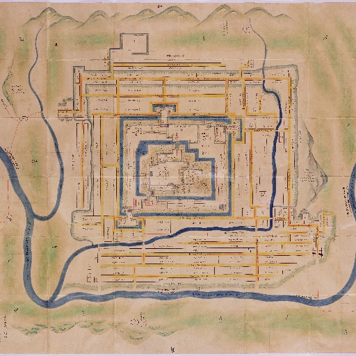
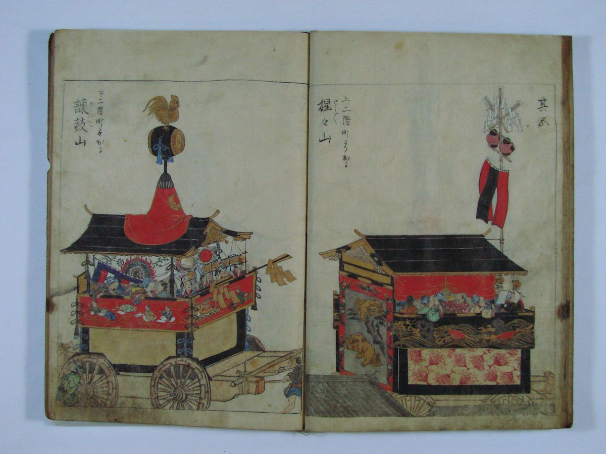
正保城絵図は、正保元年(1644年)に幕府が諸藩に命じて作成させた城下町の地図です。城郭内の建造物、石垣の高さ、堀の幅や水深などの軍事情報などが精密に描かれているほか、城下の町割・山川の位置・形が詳細に載されています。各藩は幕府の命を受けてから数年で絵図を提出し、幕府はこれを早くから紅葉山文庫に収蔵しました。幕末の同文庫の蔵書目録『増補御書籍目録』には131鋪の所蔵が記録されていますが、現在、当館では63鋪の正保城絵図を所蔵しています。昭和61年(1986)国の重要文化財に指定されました。 原図サイズ:東西219cm×南北325cm
 Posted bysasayamashiUpdated:
 All spots information
47 spots
 Road
Road
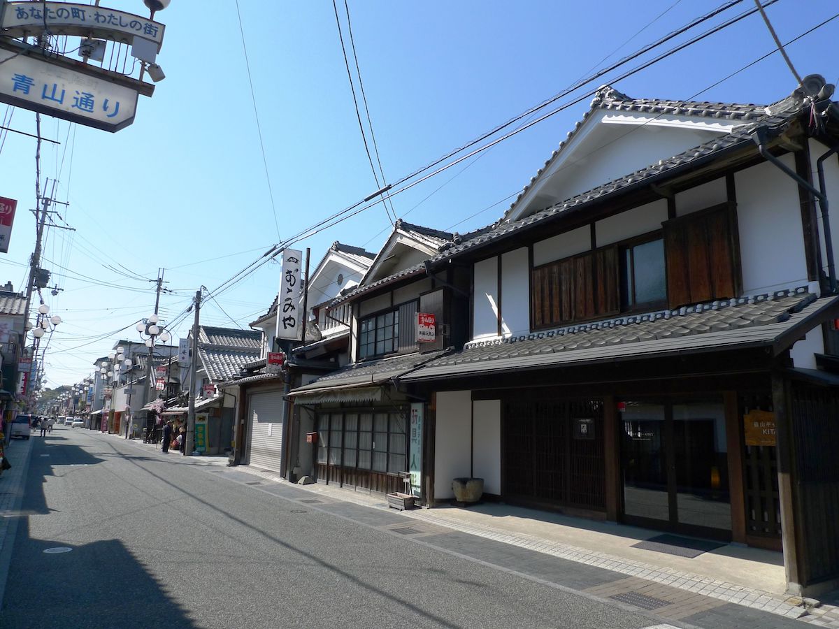
Saikyo Road
![]() Road
Road

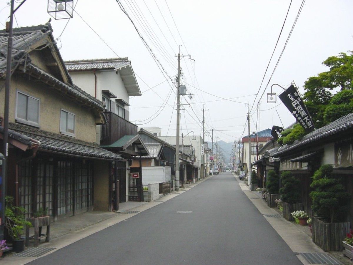
Saikyo Road is an old road that is also called "Kyo Road," "Sasayama Road," "San'in Road," etc. The Saikyo Road in Taki County (which is where Sasayama City is now) stretches east with Sasayama Castle as the sarting point and heads toward Kyoto over the Amabiki Mountain Pass. In the "Shoho Castle Illustrations" created in the first year of the Shoho era (1614), it is mentioned as "Kyo Road" and expressed with a red line. Location:Sasayama
 Place・Festival
Aoyama Shrine Festival
![]() Place・Festival
Place・Festival

The Aoyama Shrine Festival is an annual festival held once a year on the first weekend of April, and it is held to celebrate the Aoyama Clan that ruled over the Sasayama Domain. Elementary schoolchildren wearing armor, naginata, etc., parade through the town towards Kasuga Shine in Kurooka to the signals of drums and conches alongside a mikoshi palanquin. Location:Kitashinmachi 1-1 The state of the Aoyama Shrine Festival:https://videotube.sasayama.jp/dtl.php?VID=697 (Link: Sasayama City Audio-Visual Library)
Kamitatsumachi
![]() Place・Festival
Place・Festival
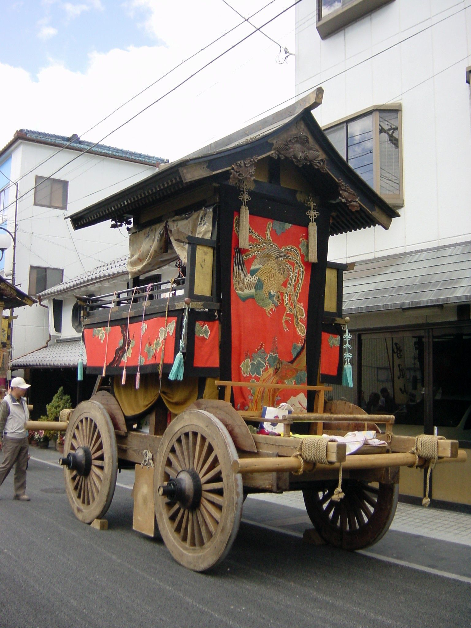
The name of the town, Tatsumachi (which can mean "standing town"), has the meaning of the town standing vertically towards the front of the castle and the course of the river, and is said to originate from transferring the town name of a castle town of Yakami Castle. In the Edo period, many merchant houses were lined up along the highway that stretches from north to south. Even in present day, some merchant houses still remain, such as the Odagaki Store, which is a national registered tangible cultural property. 〇The "Peacock Float," the hokoyama float of Kamitatsumachi The "Peacock Float" is a hokoyama float that is pulled in the festival of Kasuga Shrine, and it was built in the 5th year of the Enpo era (1677) and readjusted in the 8th year of the Meiji period (1875). The miokuri (or send-off) of the Peacock Float (the kesohin tapestry decorating the rear of the hokoyama float) was adjusted at Nishijin, Kyoto in the late Edo period, and male and female peacock are arranged with the highest quality of hand-weaving in the center, and the composition of the peonies and rocks in the background are marvelous. In Buddhism, it is said that peacocks drive away bad luck (city-designated cultural property) Location:Tatsumachi
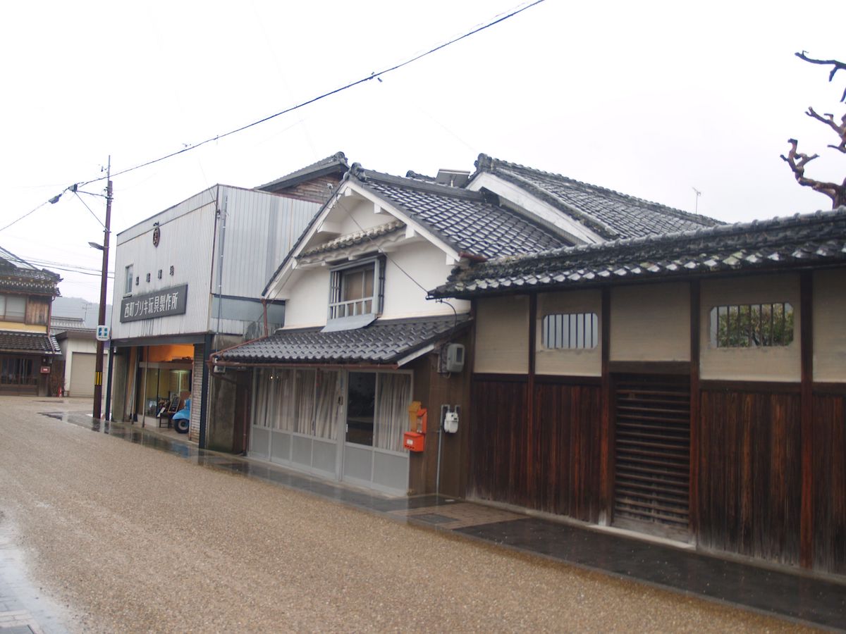
Ogawamachi
![]() Place・Festival
Place・Festival
Ogawamachi was originally alongside the Sasayama River like Kawaramachi, and it is said that it moved to the present location after Sasayama River was filled in when constructing Sasayama Castle in the 14th year of the Keicho era (1609). The townscape of the old merchant houses are left well even in present day, and in the 16th year of the Heisei period (2004), the Sasayama castle town area that included Ogawamachi was selected as an Important Preservation District for Groups of Historic Buildings of the country. 〇The "Chinese Phoenix Float," the Hokoyama Float of Shimokawaramachi and Ogawamachi The "Chinese Phoenix Float" is a hokoyama float pulled in the festival of Kasuga Shrine, and the year it was built is unknown, but records of it being readjusted in the third year of the Tenpo era (1832) remain. As its name suggests, the sacred bird, the Chinese phoenix, is depicted on the miokuri (the kesohin tapestry decorating the rear of the hokoyama festival float). The Chinese phoenix is stated to be the symbol of Tenka Taihei, which means peace in the world. Location:Ogawamachi
Gofukumachi
![]() Place・Festival
Place・Festival
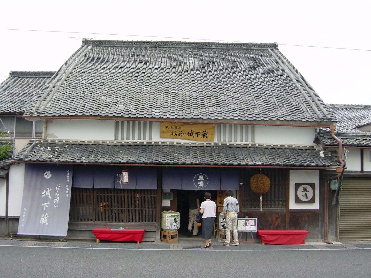
Gofukumachi was allotted as a townscape of the castle town in the 15th year of the Keicho era (1610). It was an area that propsered as a townscape of merchant houses, and even in present day, buildings that are the center of the local history and culture such as Houmei Sake Brewery (national registered tangible cultural property) and the history and art museum (the old Sasayama District Court, city-designated cultural property) are lined up. 〇The "Kenboko Pike Float," the Hokoyama Float of Gofukumachi The "Kenboko Pike Float" is a hokoyama float that is pulled in the festival of Kasuga Shrine, and it was donated in the third year of the Genroku era (1690) and readjusted in the ninth year of the Showa period (1934). The kenboko pike is a symbol of military arts, and is said to drive away disease and evil. "Xiang Yu," a military commander of China, is stated to be depicted on the miokuri (the kesohin tapestry decorating the rear of the hokoyama float), and the scene of him raising a Ding (a three-legged vessel) is depicted. Location:Gofukumachi
Kasuga Shrine Festival
![]() Place・Festival
Place・Festival
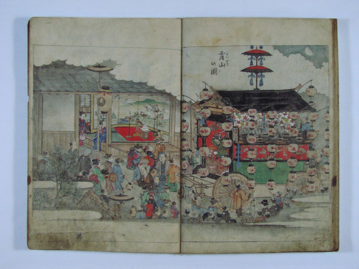
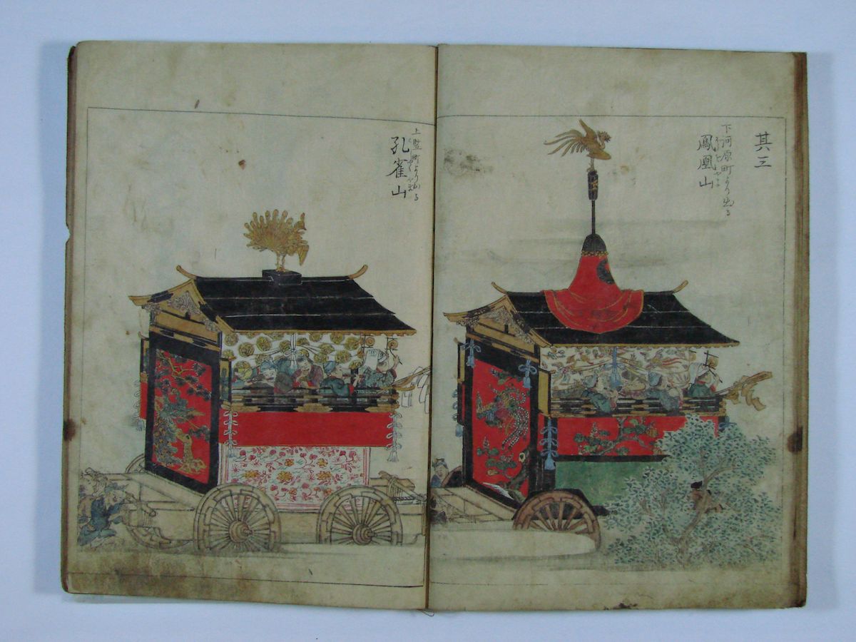
The Kasuga Shrine Festival is held every year in October. The form of the festival in which hokoyama floats from each village are pulled like in present day is said to have come from the third year of the Kanbun era (1663), and this form is thought to have been influenced by the Gion Festival in Kyoto. This kind of form of festival could be said to have been a symbol of developed cities at the time. The sight of Hokoyama (wheeled shrines that are pushed or pulled), festival floats of each town parading the castle town has become a reminder of the fall season in Sasayama (city-designated intangible folk-cultural property). Location:Sasayama Castle Town The State of the Festival:https://videotube.sasayama.jp/dtl.php?VID=1037 (Link: Sasayama City Audio-Visual Library)
Kamikawaramachi
![]() Place・Festival
Place・Festival
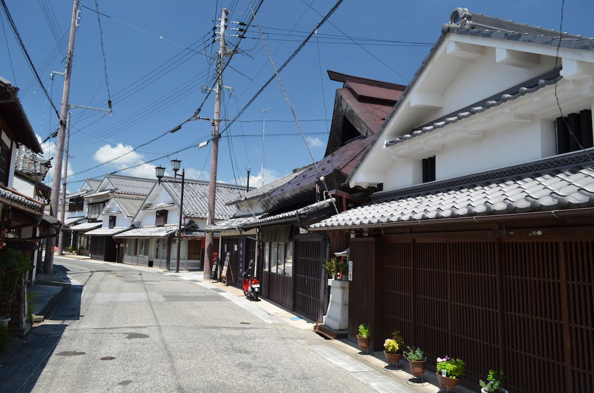
The name of the town, Kawaramachi (which can mean "dry riverbed town), originates from it being built on the dry riverbed of the Sasayama River in the 14th year of the Keicho era (1609) when constructing Sasayama Castle. It was the center of commerce from the end of the Edo period to the middle of the Meiji period, and many stores of various types including banks were lined up alongside each other. The townscape of the old merchant houses are left well even in present day, and in the 16th year of the Heisei period (2004), the Sasayama castle town area that included Kawaramachi was selected as an Important Preservation District for Groups of Historic Buildings of the country. 〇The "Mikasayama Float," the Hokoyama Float of Kamikawaramachi The "Mikasayama Float is a hokoyama float that is pulled in the festival of Kasuga Shrine and it is said to be the oldest among the nine hokoyama floats, being built in the third year of the Kanbun era (1663). The name, Mikasa, is likening it to Nara Prefecture's Mount Mikasa, where Kasuga Grand Shrine is located. The miokuri (the kesohin tapestry decorating the rear of the hokoyama float) depicts the scene of Susanoo-no-Mikoto, a deity of Japanese myth, slaying the legendary beast, Yamata no Orochi. Location:Kawaramachi
Shimotatsumachi
![]() Place・Festival
Place・Festival
The name of the town, Tatsumachi (which can mean "standing town"), has the meaning of the town standing vertically towards the front of the castle and the course of the river, and is said to originate from transferring the town name of a castle town of Yakami Castle. In the Edo period, many merchant houses were lined up along the highway that stretches from north to south. Sompo-ji Temple and Raigo-ji Temple, which were arranged at the northeast, which is an unlucky direction, of Sasayama Castle to keep away the bad luck, characterizing the townscape. 〇The "Takasagoyama Float," the Hokoyama Float of Shimotatsumachi The "Takasago Float" is a hokoyama float that is pulled in the festival of Kasuga Shrine, and it was built in the fifth year of the Enpo era (1677) and was readjusted in the eighth year of the Meiji period (1875). The "Takasago" of the miokuri (the kesohin tapestry decorating the rear of the hokoyama festival float) is a Noh play piece and is a symbol of good luck that celebrates the love between husband and wife and long life near 'Aioino matsu,' twin pines. On the miokuri (the kesohin tapestry decorating the rear of the hokoyama festival float) of the Takasagoyama Float as well, the figures of Okina (old man) and Ouna (old woman) in front of pines are depicted, and it is made a pattern of good luck that celebrates the world of people. Location:Tatsumachi
Shimokawaramachi
![]() Place・Festival
Place・Festival
The name of the town, Kawaramachi (which can mean "dry riverbed town"), originates from it being built on the dry riverbed of the Sasayama River in the 14th year of the Keicho era (1609) when constructing Sasayama Castle. It was the center of commerce from the end of the Edo period to the middle of the Meiji period, and many stores of various types including banks were lined up alongside each other. Many houses with a long depth can be seen, but there are also large-scale merchant houses with wide fronts like the Kawabata family house and the Nishizaka family house. The townscape of the old merchant houses are left well even in present day, and in the 16th year of the Heisei period (2004), the Sasayama castle town area that included Kawaramachi was selected as an Important Preservation District for Groups of Historic Buildings of the country. 〇The "Mount Hōō Float," the hokoyama float of Shimokawaramachi and Ogawamachi The "Mount Hōō Float" is a hokoyama float pulled in the festival of Kasuga Shrine, and the year it was built is unknown, but records of it being readjusted in the third year of the Tenpo era (1832) remain. As its name suggests, the sacred bird, the Chinese phoenix, is depicted on the miokuri (on the kesohin tapestry decorating the rear of the hokoyama float). The Chinese phoenix is stated to be the symbol of Tenka Taihei, which means peace in the world. Location:Kawaramachi
Kaminikaimachi
![]() Place・Festival
Place・Festival
Several historical merchant house buildings are dotted about in Nikaimachi even in present day, and it has become the center of a base for sightseeing as a central shopping district in the city. 〇The "Shojoyama Float," the Hokoyama Float of Kaminikaimachi The "Shojoyama Float" is a hokoyama float pulled in the festival of Kasuga Shrine, and it was built in the fouth year of the Jokyo era (1687) and was either restored or newly built in the first year of the Bunka era (1804). The Shojo is an imaginary animal, and it is a symbol of good luck that is also sung about as Noh songs in Noh plays. Karajishi lions are depicted on the miokuri (on the kesohin tapestry decorating the rear of the hokoyama float), and they hold the meaning of driving away evil spirits and celebrating the world. Location:Nikaimachi
Shimonikaimachi
![]() Place・Festival
Place・Festival
Several historical merchant house buildings are dotted about in Nikaimachi even in present day, and it has become the center of a base for sightseeing as a central shopping distrct in the city. 〇The "Kankoyama Float," the Hokoyama Float of Shimonikaimachi The "Kankoyama Float" is the hokoyama float pulled in the festival of Kasuga Shrine, and the year it was built is unknown, and it was readjusted in the 11th year of the Showa period (1936). The miokuri (the kesohin tapestry decorating the rear of the hokoyama float) is a "kanko bird." A kanko was a drum that was beaten when the people complained to the public office. There is an ancient Chinese folklore which states that, as excellent rulers often ruled over the country, there were no more people who complained to the public office and the kanko drum became unnecessary and a chicken made its nest inside the ripped drum. From this, the "kanko bird" became a symbol of peace. Location:Nikaimachi

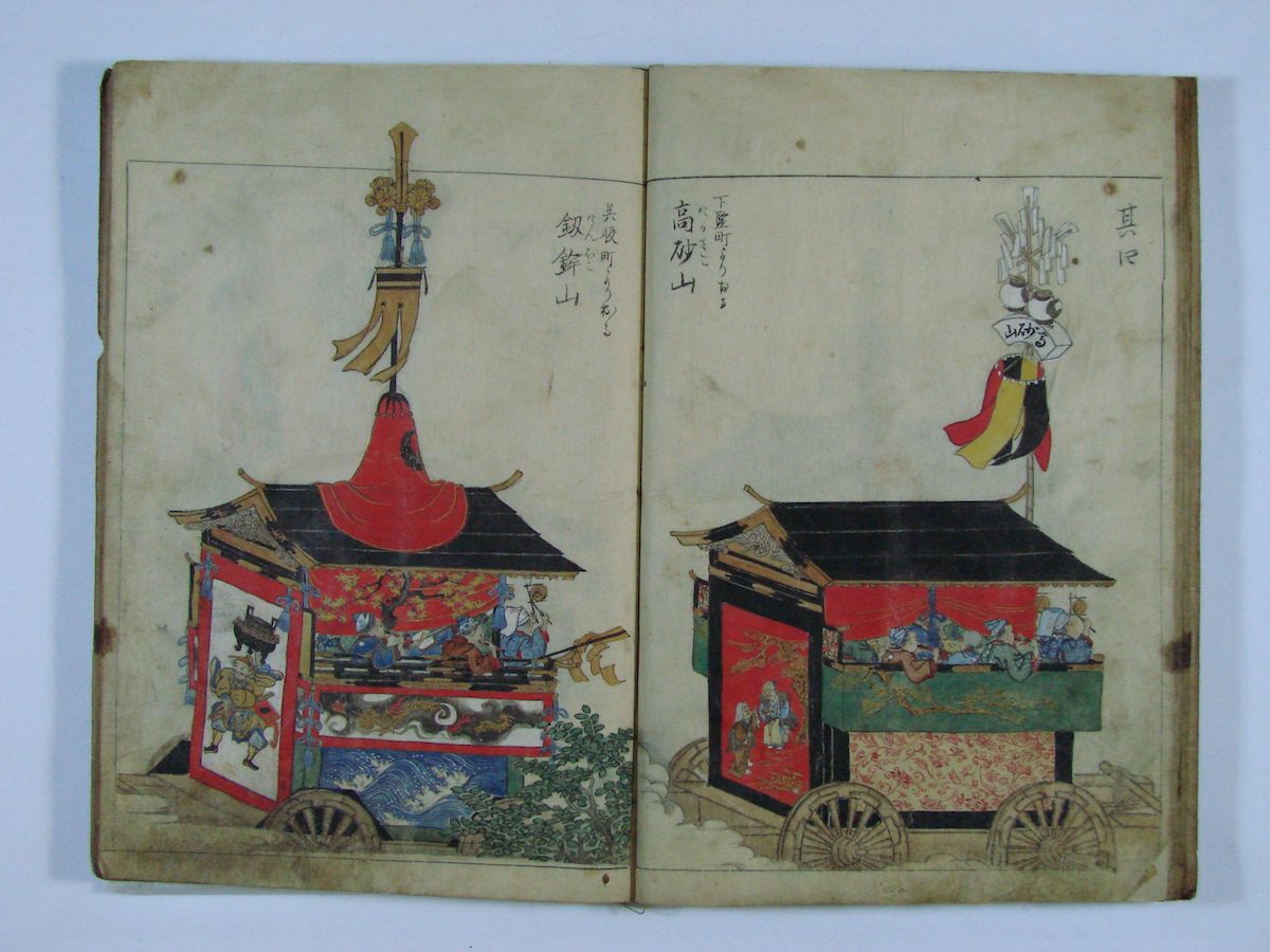
Uoyamachi is known as "Sakanamachi" in the "Shoho Castle Illustrations" created in the first year of the Shoho era (1614), and its landmarks are made to be Seigan-ji Temple and its tower gate. 〇The "Sotetsuyama Float," the Hokoyama Float of Uoyamachi The "Sotetsuyama Float" is a hokoyama float pulled in the festival of Kasuga Shrine, and it was built in the fourth year of the Jokyo era (1687) and readjusted in the third year of the Meiji period (1870). As the shape of the Japanese sago palm leaves are similar to the tail of the Chinese phoenix, it is made a symbol of good luck. A scene of a person made to be Zhang Fei or Guan Yu, heroes of the Records of the Three Kingdoms, wielding a spear on horseback, is depicted on the miokuri (the kesohin tapestry decorating the rear of the hokoyama festival float). Location:Uoyamachi
Nishimachi
![]() Place・Festival
Place・Festival
A townscape of merchant houses was once formed in Nishimachi. Even in present day, a comparatively large number of merchant house buildings have been left. 〇The "Kagamiyama Float," the Hokoyama Float of Nishishinmachi The "Kagamiyama Float" is a hokoyama float that is pulled in the festival of Kasuga Shrine. The miokuri (the kesohin tapestry decorating the rear of the hokoyama float) was adjusted in Kyoto in the second year of the Ansei era (1855) at the end of the Edo period, and the pattern expresses the three worlds of the Buddhist paradise, the Ryugu Dragon Palace and the land of Tang, and it is a hand-woven masterpiece rich with artistic quality (city-designated cultural property). Location:Nishimachi
 Building
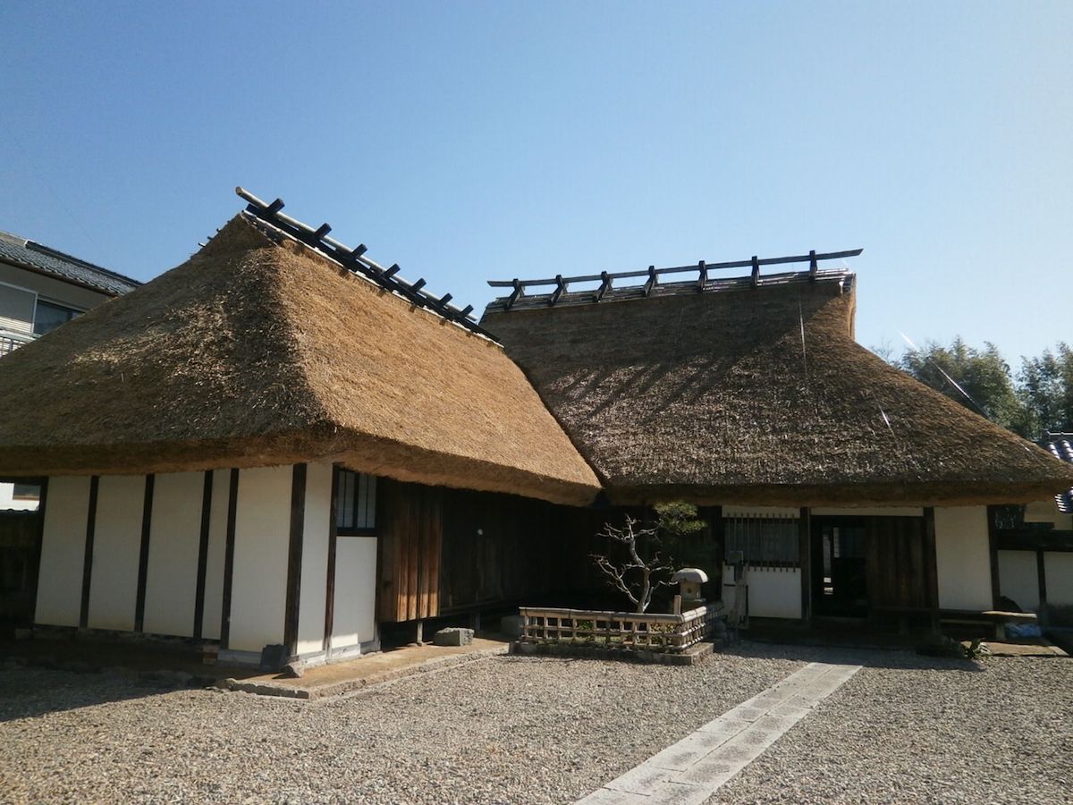
The Samurai House Anma Family Museum is the house of the Anma family, retainers of the Aoyama family that were the feudal lords of the Sasayama Domain, which has become a facility open to the general public as a museum. The main building, which is thatched and in the magariya form (L-shaped), a style often seen in Okachimachi, and the storehouse with the tiled roof, have been left. The garden was arranged in later years and was used as a vegetable garden at the time. (City-designated cultural property). Location:Nishishinmachi 95 Official Home Page:http://www.withsasayama.jp/REKIBUN/anma_top.htm
Houmei Sake Brewery
![]() Building
Building

Houmei Sake Brewery is a long-established sake brewery, and it does business as a sake brewing company even in present day. The main building is built to face the street, it has a well hole style passage with an earth floor and it is also combined with the store. A single-story office room and storehouses stand in a row on the west of the main building, and it forms a street scene with a sense of continuity (national registered tangible cultural property). Location:Gofukumachi 73
The Odagaki Store
![]() Building
Building
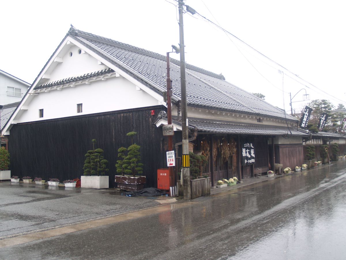
The Odagaki Store was once a merchant house where the Yaegaki Sake Brewery (Danno Family) managed a sake brewing business from the end of the Edo period to the early Showa period, and it has now become a store that deals in black soybeans, etc. The store, which stands to the north of the site facing Saikyo Road, shows a dignified appearance and stretches out a long wall to the south, forming the scenery of a long-established merchant house. Moreover, a miso storehouse, a storehouse, a lavatory and bath building and a tearoom stand in a row on the south half, and furthermore, a detached room facing the tearoom is arranged for waiting on customers, making a calm space that faces inward. The Odagaki Store shows the form of a large-scale town house in the castle town of Sasayama Castle in the late 18th Century, and it is also important as proof showing that the character of the merchant that flourished in Hanshinkan, who treated customers with tea in a house with Japanese and foreign parallels, also existed in the land of Tamba (national registered cultural property). Location:Tatsumachi 9
Takajo House Gate
![]() Building
Building
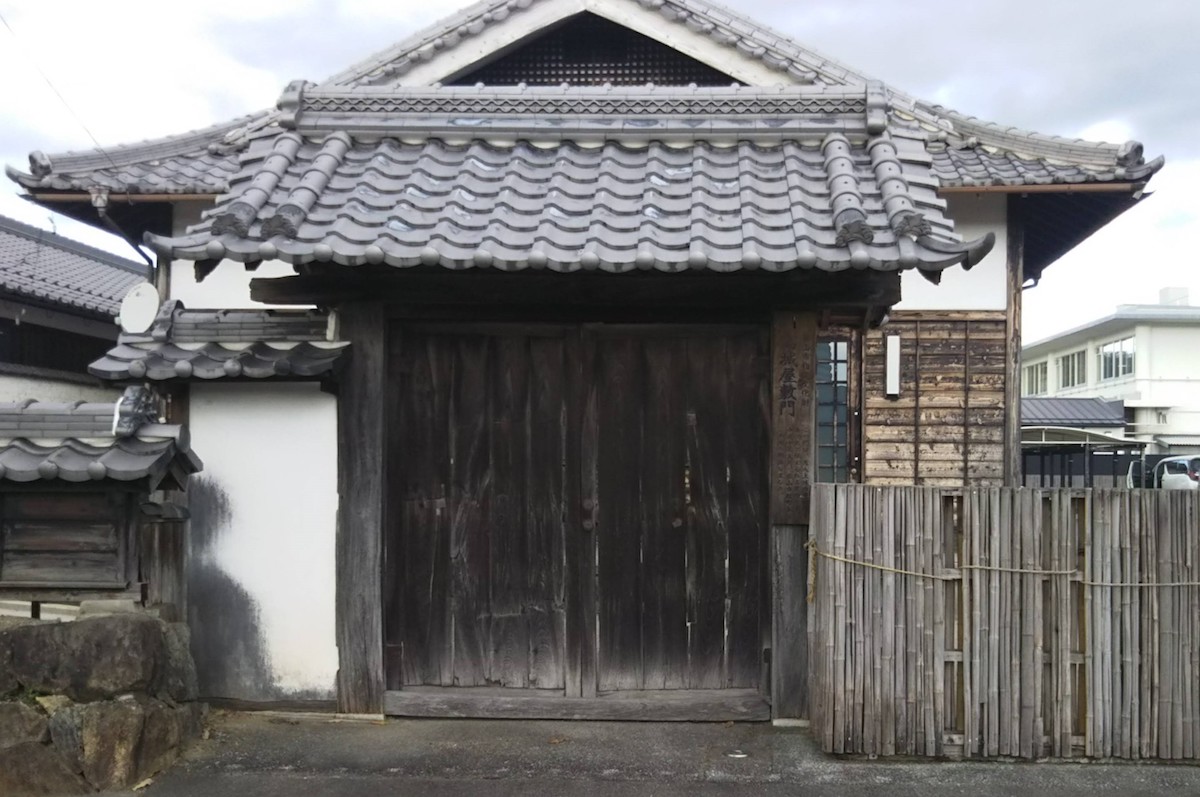
The Takajo House Gate is the house gate that used to be in Yakami Castle, which was the castle of the Hatano Clan, the Sengoku daimyos that ruled Taki County (which is almost where Sasayama City is now), and it was removed and rebuilt in later years as a samurai house gate in the castle town of Sasayama Castle. In the early stage of its construction, it was thatched, but it was renovated with a tile roof after being removed and rebuilt. There are ruins of its repairs in later years, but it is thought that it was founded earlier than the time of Muromachi, and it has a very high value as the only remains of a building related to Yakami Castle (city-designated cultural property). Location:Kitashinmachi

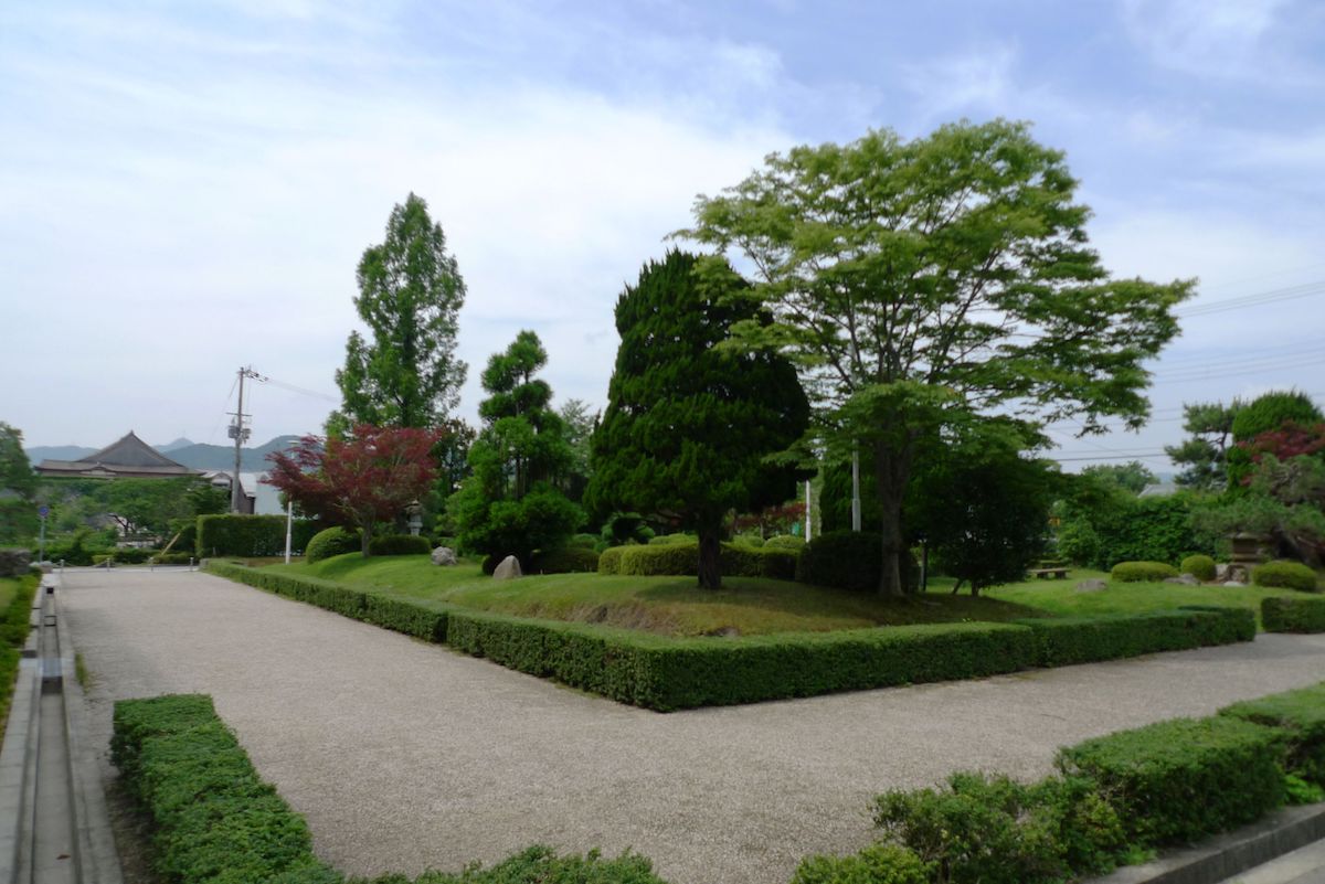
Okachimachi is an area where samurai houses constructed in the Edo period were lined up. In the "Shoho Castle Illustrations" created in the first year of the Shoho era (1614), it is known as "Samurai Estates." A kachi (the same "kachi" in "Okachimachi") refers to low-ranking samurai who did not ride on horses. The division of the sites of the Edo period have been left, and an earthen wall and munemon gate have been arranged alongside the road. Japanese persimmon trees and Japanese chestnut trees have been planted in the sites of the thatched samurai houses. Bamboo groves planted at the time of forming the castle town for the purpose of protecting the castle town have also been left and they characterize the historical scene of the castle town of Sasayama Castle. In the 16th year of the Heisei period (2004), the castle town area of Sasayama Castle including Okachimachi was selected as an Important Preservation District for Groups of Historic Buildings of the country. Location: Nishishinmachi Location:Nishishinmachi
The Kobayashi Family Nagaya-mon Gate was the Nagaya-mon gate of the house that was repaired in the years of the Bunka era (1804-1818) by Tadayasu Aoyama, the 12th feudal lord of the Sasayama Domain, for the old woman Chie Kobayashi. It faces the west moat of Sasayama Castle and is a valuable building that transmits the traces of that time (Hyogo Prefecture-designated important cultural property). Location:Nishishinmachi 24
The Nishisaka Family House
![]() Building
Building

The Nishisaka Family House is a house of the Tsumairi style, which is often seen in residences of Kawaramachi, with distinctive white plaster walls and latticed bay-windows. In the Edo period, it was run as a soy sauce store (city-designated cultural property). Not open to the public. Location:Kawaramachi 204
Aoyama Historical Village
![]() Building
Building
Aoyama Historical Villageis made up of three storehouses and a Nagaya-mon gate centered around the Keiensha, which was a secondary house of the Aoyama family, who were the feudal lords of the Sasayama Domain, and in present day, it is open to the general public. (1)The Old Sawai Family Nagaya-mon GateIt is said to have been constructed in the years of the Bunka era (1804-1818), and it was removed and rebuilt in its present location when it was donated by the house of Sawai, the old feudal lords of the Sasayama Domain (the house on the east side corner of the southern moat), to "Aoyama History Village." One half of the gate was used as the room for gatekeepers, etc., and the other half was used as a stable. At the time, owning a horse and building a Nagaya-mon gate was the proof of a high-ranking samurai. It is a thatched building, and a valuable building where one can perceive the way of life of samurai at the time (city-designated cultural property). (2)KeienshaThe Keiensha was a building of a village headman that used to be in what is now Kuroda, Sasayama City and was removed and rebuilt in the 20th year of the Meiji period (1887). The origin of its name is from a school of waka poetry, the "Keien school," which had the first mayor of Sasayamacho, Naoki Ando, as their judge. In present day, it is open to the general public. Location:Kitashinmachi 48 Official Home Page:http://www.withsasayama.jp/REKIBUN/aoyama_top.htm
Kawabata Family House
![]() Building
Building

The Kawabata Family House was a town house of the time of Meiji and Taisho, and is a house that represents the group of merchant houses of Kawaramachi which hold around 730 tsubo (around 2,413 square meters) with their premises. It is a building of the early Meiji times, and the detached room was built in the 9th year of the Taisho period (1920) as a guest room in times when the Imperial Household visited (city-designated cultural property). It is not open to the public. Location:Kawaramachi 200
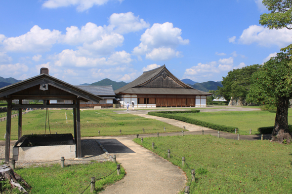
The Ohshoin was where the Domain administration of the Sasayama Domain was held, and it was built near the time of the construction of Sasayama Castle in the 14th year of the Keicho era (1609). It was not demolished even after the abolishment of the Domain system and was used as an elementary school or a public hall and was familiar with the townspeople, but it burned down in the 19th year of the Showa period. After that, through the donations of the townspeople, etc., a faithful restoration that applied historical materials of the Domain administration, old maps and old photographs was made on March of the 12th year of the Heisei period (2000). As a wooden residential building, its scale is very large, and it is of an extraordinary scale for a Shoin for one daimyo. In present day, it is open to the general public, and one can see a display that explains the state of Sasayama in the Edo period and the history of the Sasayama Domain. Location:Kitashinmachi 2-3 Official Home Page:http://www.withsasayama.jp/REKIBUN/osyoin_top.htm
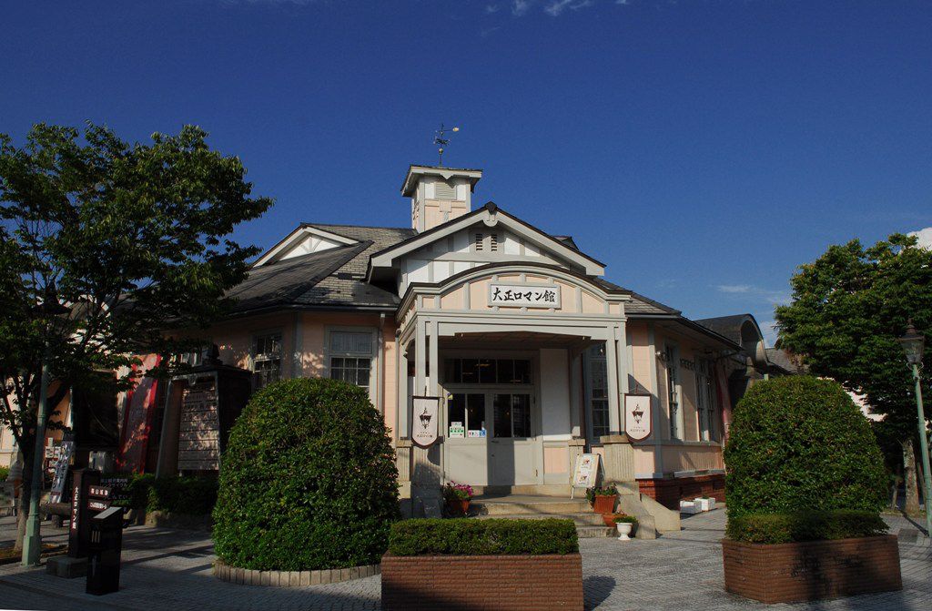
The Taisho Roman-kan is a wooden Western style building which was built as the Sasayamacho town office in the 11th year of the Taisho period (1922), and it is now used as a tourism facility. It was a very modern make as a building at the time, and it was used as the Sasayamacho town office as a symbol of Sasayamacho up until the construction of the present Sasayama city office in the fourth year of the Heisei period (1992). Location:Kitashinmachi 97 Official Home Page:http://tanbasasayama.hyogo.jp/

The Historical Art Museum was the oldest wooden courthouse in Japan constructed in the 24th year of the Meiji period (1891), and it is a facility open to the general public in present day. It was used as a courthouse up until the 57th year of the Showa period (1982), and an entrance carriage porch was placed in the center with courtrooms arranged on the left and right. It is a building in the shape of an E when on a flat plane, inheriting a typical structure to wooden government office buildings of the early Meiji period. It originally faced the shopping district on the south side, but it was moved to its present location through city planning. Location: Gofukumachi 53 Official Home Page:http://www.withsasayama.jp/REKIBUN/rekibi_top.htm
 Historic

The old Japanese National Railways Sasayama Station was a station of the Sasayama line that was opened from the 19th year of the Showa period (1944) to the 47th year of the Showa period (1972). It passed through Yakami, Tanbahioki, Murakumo and connected up to Fukusumi (before the opening of the Sasayama line, the present JR Sasayamaguchi Station was "Sasayama Station"). The Sasayama line was originally planned to connect from what is now Sonobe Station (the present Sonobecho of Nantan City in Kyoto) to Sasayama, and activities to invite and attract people were developed in the surrounding regions including Fukusumi. Then, during the war in the 19th year of the Showa period (1944), the Sasayama line that connected from what is now the JR Sasayamaguchi to Fukusmi was opened in order to carry resources used in the war such as manganese mined out of Honmyodani in Fukusumi. Even after the war, it was used to commute to work and school, but through the policy of organizing unremunerative local lines of the old Japanese National Railways, the line was discontinued in the 47th year of the Showa period (1972). Location:Kita The state of the Sasayama line on the day it was discontinued:https://videotube.sasayama.jp/dtl.php?VID=34 (Link: Sasayama City Audio-Visual Library)
Umadashi are areas built on the outside of the outer moat in order to strengthen the defenses of the castle entrance, and they were also used when attacking from the castle by gathering the army together and attacking all at once. Umadashi were set up in the Oote, the east and the south of the castle. The Taki Welfare Office was once built on the East Umadashi in the 26th year of the Meiji period (1893), but it was demolished in the 53rd year of the Showa period (1978). At present, the East Umadashi has been arranged as a park. Location:Kitashinmachi
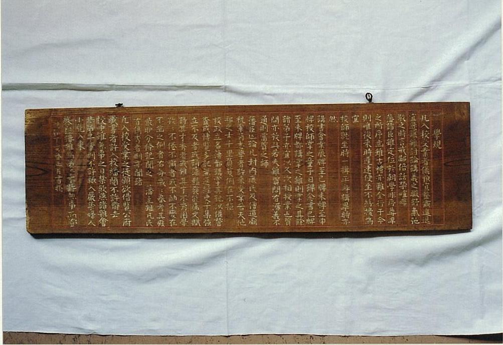
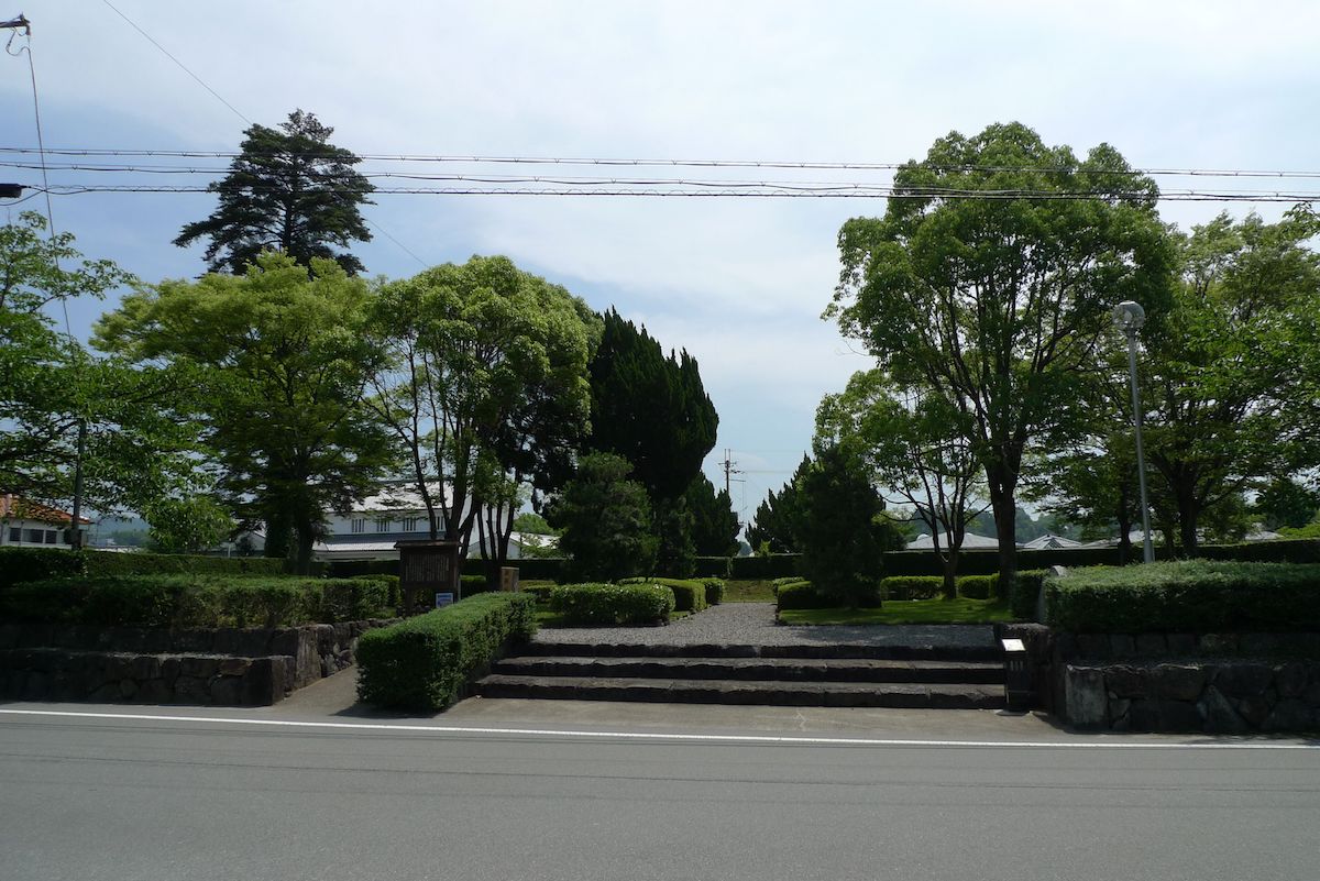
Shintokudo was the Domain School of the Sasayama Domain. It began when it was founded in the third year of the Meiwa era (1767) by Tadataka Aoyama, the tenth feudal lord of the Sasayama Domain, due to not many people aspiring to study among the feudal retainers. In the third year of the Tenmei era (1783), a school building was built in the southwest of Sasayama Castle separate from the moat of the South Umadashi. Shintokudo established "Gakki" (the rules of the Domain School) as the rules for the students. Its contents were very civilized, and included (1) Entrance is allowed for the general public, (2) Entrance is allowed for people from other Domains who aspire to enter, (3) A system of obligation to enter for children of feudal retainers, etc. Furthermore, they did not take tuition fees, including from the children of feudal retainers. At present, valuable objects that tell of Shintokudo, including a framed picture that has the Gakki written on it, are stored in the Hyogo Prefectural Sasayama Homei High School (city-designated cultural property). Location:Nishishinmachi 24

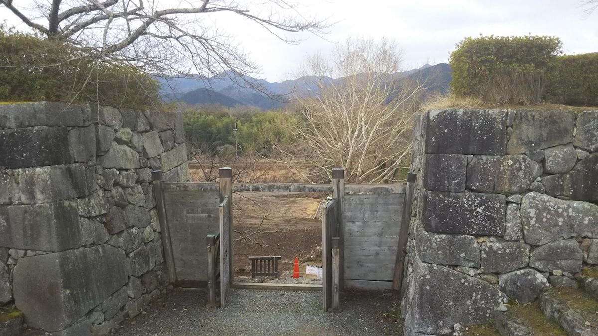
Umadashi are areas built on the outside of the outer moat in order to strengthen the defenses of the castle entrance, and it was also used when attacking from the castle by gathering the army together and attacking all at once. Umadashi were set up in the Oote (the front of the castle), the east and the south. The south Umadashi was of the largest scale even among the Umadashi of Sasayama Castle and the earthwork with a width of 38.2 m from east to west, a width of 23.6 m from north to south and a height of 4 m exists today. It is the only relic of an "Earthwork Umadashi" that was built without using stone walls up to below the water's surface. Location:Kitashinmachi
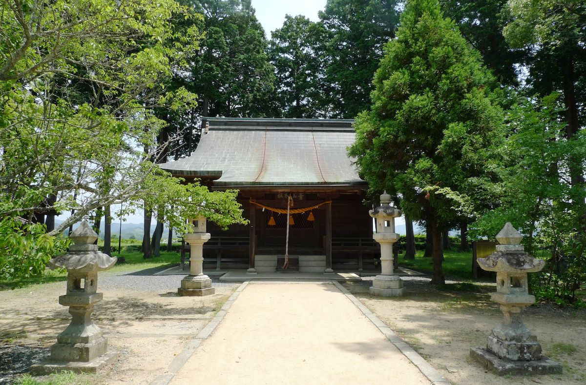
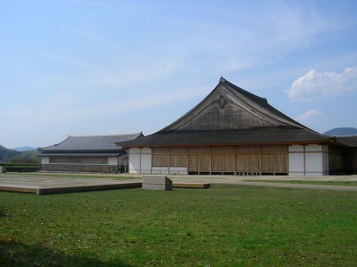
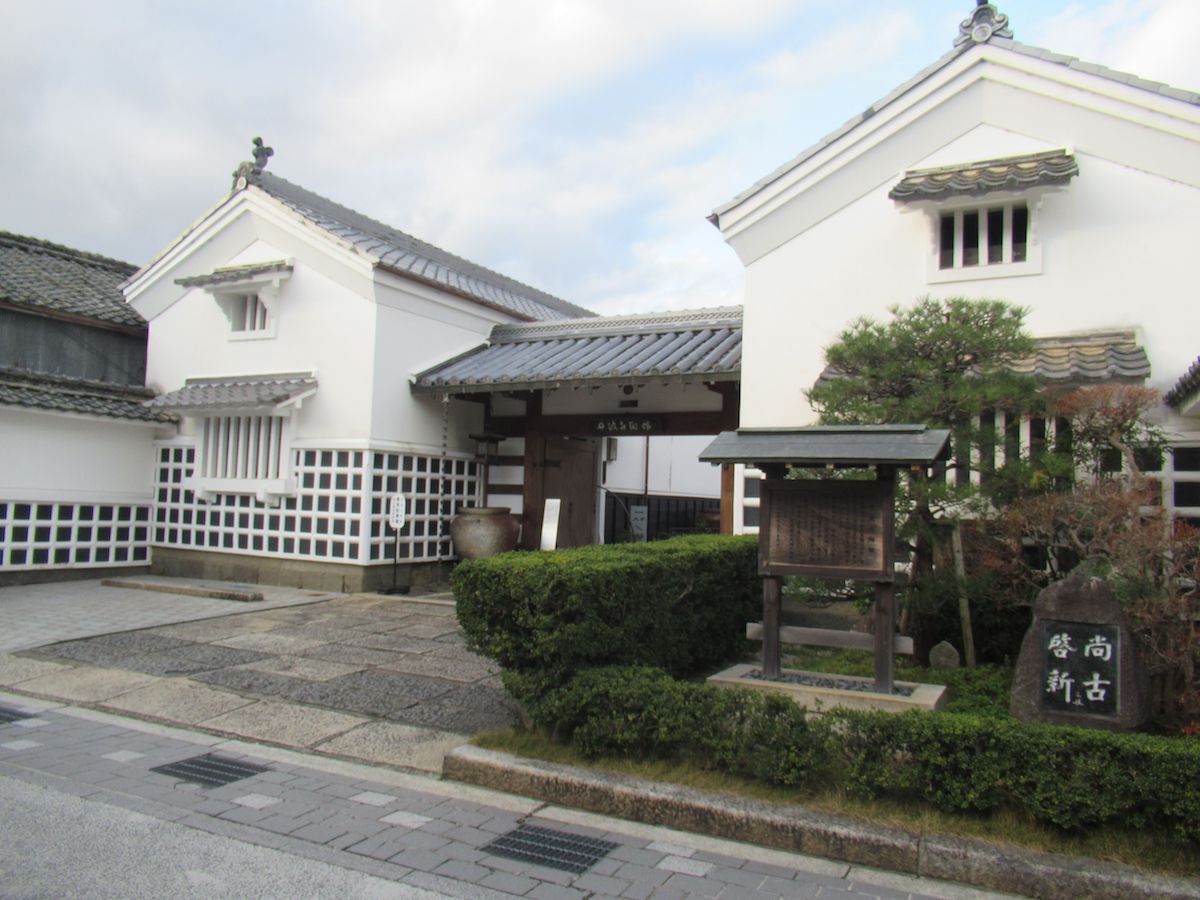
Sasayama Castle was built in the 14th year of the Keicho era (1609) by Ieyasu Tokugawa, who was trying to set his resolve firmly on ruling the country, in order to restrain the daimyos of western Japan connected to the Toyotomi family as well as surround Osaka Castle, which was the base of the Toyotomi side. The castle takes on a position that is devoted to defense, being constructed by using a hill which was called "Sasayama" at the time, being surrounded by two layers of moats and setting up Umadashi in three directions of the outer moat to heighten defenses of the entrances and exists, etc. A Tenshu keep was not built, but a palace represented as a Ohshoin guest space was built in the Ninomaru bailey. Furthermore, at the time of construction, it was also called "Tenshumaru," and in the "Shoho Castle Illustrations" created in the first year of the Shoho era (1614), it is also mentioned as "Tenshumaru." At present, Aoyama Shrine, which is a shrine that has Tadatoshi Aoyama, the remote ancestor of the old Aoyama family feudal lords, and Tadayasu Aoyama, who is called the feudal lord of the restored Aoyama family, as the enshrined deities, has been built on the Honmaru bailey ruins. Location:Kitashinmachi 1-1
The Ninomaru bailey of Sasayama Castle had living spaces apart from the Ohshoin guest space which appeared to be kitchens and offices for government officials, and it had the castle lord's living room and private quarters further in the back and a garden on the south side. This state at the time does not exist in present day, and there are flat displays of the palace layout that have been made known through layout diagrams, illustrations, excavation and research, etc. Location:Kitashinmachi 1-1
The Sasayama Castle Uzumimon gate was on the south side of the Ninomaru bailey, and it was made so that it could be filled in and cut off when shutting up inside the castle due to being attacked by the enemy. Looking at the "Shoho Castle Illustrations" created in the first year of the Shoho era (1614), there was a turret here, and it can be seen that it displayed strong defenses. Location:Kitashinmachi 1-1
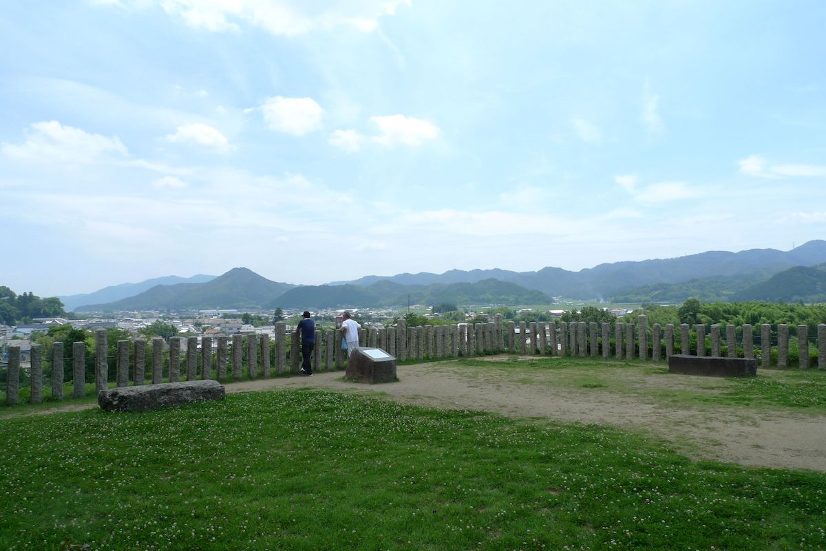
Due to Ieyasu Tokugawa, who ordered the construction of the castle, wishing to quickly build a practical castle, no Tenshu keep was built on Sasayama Castle. In the "Shoho Castle Illustrations" created in the first year of the Shoho era (1614), it is written, "Tenshu Keep Base No Gotenshu Keep." Furthermore, the mountain drawn on the east edge in the "Shoho Castle Illustrations" is Takagiyama Mountain, which is where the Yakami Castle Ruins (the castle of the Sengoku daimyos of the Hatano Clan) that can be seen from this Tenshu Keep Base, is located. Location:Kitashinmachi 1-1
Stone Walls
![]() Historic
Historic
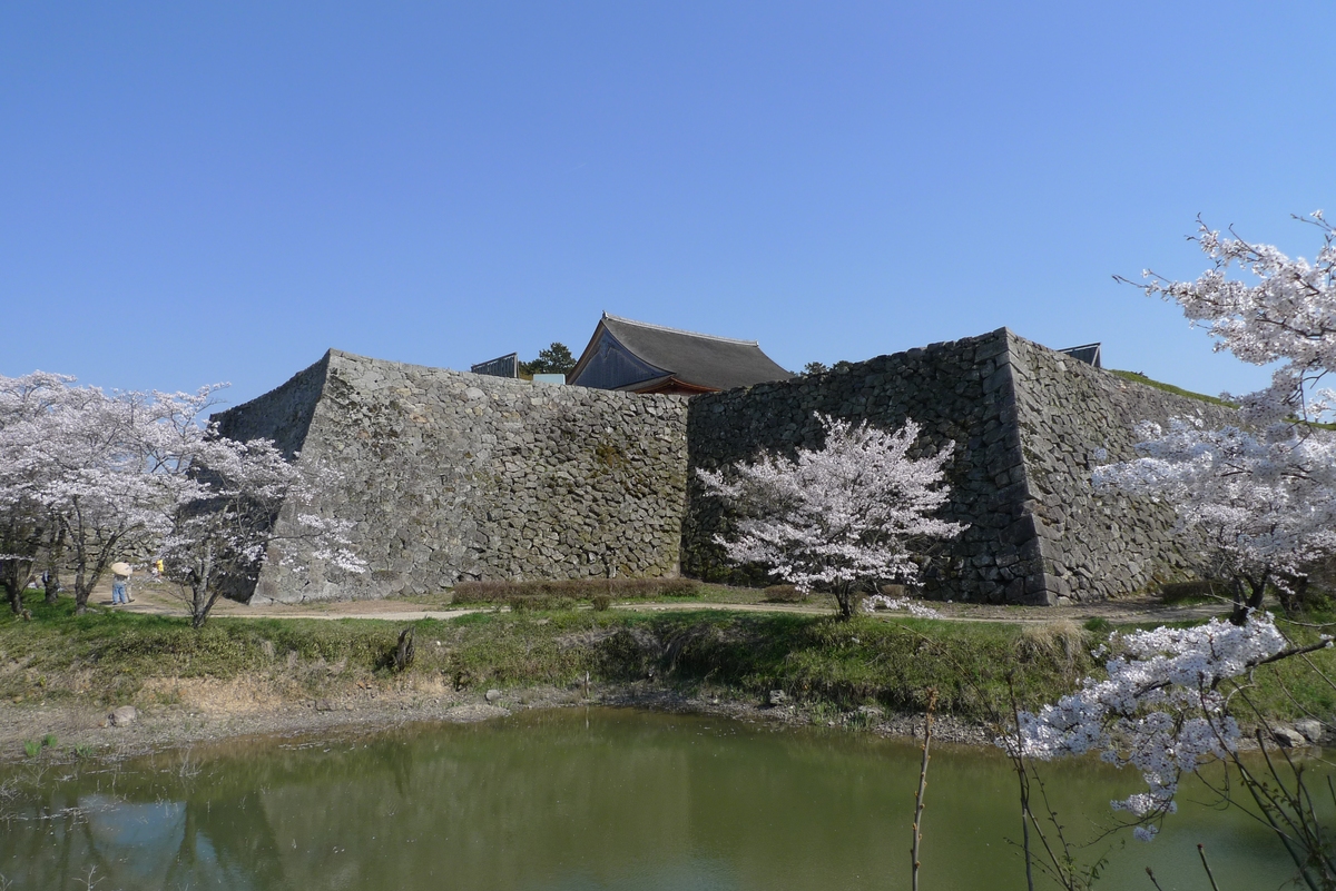
The stone walls of Sasayama Castle were built through the guidance of stonemasons invited from Anou, Omi Province (Shiga Prefecture). The people of Anou were famous as a group of stone wall artisans, and their characteristic construction method called nozurazumi, which is stacking natural stones without adding processing to the stones, has been used. Furthermore, in order to raise the strength of the entire stone wall, they have used a construction method on the external corners of the high stone walls called sangizumi, which is having the long side and short side of the walls mutually combine. Marks called fugo are sometimes placed on stone walls, but Sasayama Castle is said to have a large number of fugo after Osaka Castle and Nagoya Castle. There are various theories on the reason behind placing the fugo, such as it was to ensure a scramble for stones would not happen between the daimyo who took part in the construction of the stone walls, or it was the mark of the group of artisans who participated in the construction of the stone walls. Location:Kitashinmachi

In the Sannomaru bailey, government offices and audience halls (facilities used when samurai of master-servant relations met with each other) were placed on the north side, and on the east and west sides, estates were arranged in a way so that they surrounded the Honmaru and Ninomaru baileys. In the "Shoho Castle Illustrations" created in the first year of the Shoho era (1614), the four corners of the Sannomaru bailey were surrounded by Umadashi and turrets and it can be seen that they displayed strong defenses. Furthermore, there was a rice granary near the inner moat on the northeast of the Sannomaru bailey. Location:Kitashinmachi 1-1
Umadashi are areas built on the outside of the outer moat in order to strengthen the defenses of the castle entrance, and they were also used when attacking from the castle by gathering the army together and attacking all at once. Umadashi were set up in the Oote (the front of the castle), the east and the south. In the tenth year of the Taisho period (1921), the Oote Umadashi was filled in, and at present, a part of the earthwork is left. In the "Shoho Castle Illustrations" created in the first year of the Shoho era (1614), the Ootemon Gate is drawn near the Oote Umadashi. Sasayama Castle also had the east gate and the south gate, but both were gates that had turrets called Yaguramon placed on them, and it can be seen that they displayed strong defenses. Location:Kitashinmachi
 Temple・Shrine
Oojiyama Inari
![]() Temple・Shrine
Temple・Shrine

Oojiyama Makekirai Inari was constructed in the fifth year of the Genna era (1619) at the same time as Honkyo-ji Temple. There was a single main hall of worship building in the middle of the Edo period, but it burned down in the 20th year of the Showa period (1887). In the 23rd year of the Meiji period (1890), the present hall of worship was constructed, and in the 31st year of the Meiji period (1956), the offertory hall and the sanctuary was constructed. 〇Story "The Inari Who Hated to Lose." One of the stories left in Sasayama. In the Edo period, a grand sumo tournament was held every year in the spring and fall seasons, but the sumo wrestlers of Sasayama were always losing. The ruler of the Domain at the time, Tadayasu Aoyama, hated losing, and so was always in a bad mood at the time of sumo. One year in the spring grand sumo tournament, ten sumo wrestlers appeared before Tadayasu and requested that they be allowed to partake in the sumo wrestling. After trying them out in the sumo wrestling, they crowned themselves with a succession of victories. Overjoyed, Tadayasu was about to give them a reward, but when he looked for them afterwards, the ten sumo wrestlers were nowhere to be seen, and the names of all the sumo wrestlers were found to be the names of the Aoyama Family Domain's villages where the Inari deity was enshrined. Upon knowing this, Tadayasu made an offering of banner flags and ema plaques filled with feelings of gratitude to each Inari deity. The same banner flags and ema plaques are carefully kept in Tobinoyama Sanshiro Inari in Nishiokaya, Sasayama City. From this story, Oojiyama Inari Shrine is known as a shrine of a deity for praying for victory. Location:Kawaramachi
Kannon-ji Temple
![]() Temple・Shrine
Temple・Shrine

Kannon-ji Temple is a Zen temple of the Soto school founded in the fifth year of the Eiroku era (1562). Through the influence of the mother of Hideharu Hatano, the Sengoku daimyo who ruled Taki County (which is almost where Sasayama City is now), the temple, which was located where Chisoku, Sasayama City is now, was removed and rebuilt in the castle town of Yakami Castle. After the fall of the Hatano Clan, it moved to its present location in Kawaramachi in the 15th year of the Keicho era (1610), accompanying the construction of Sasayama Castle. The main hall was constructed after it was moved to Kawaramachi, on January 11th of the tenth year of the Kanbun era (1670). Furthermore, the present main hall was rebuilt in the tenth year of the Kyoho era (1725). The Wooden Statue of the Standing Eleven-Faced Kannon in its possession is said to be a piece from the Heian period (city-designated cultural property). Location:Kawaramachi 165
Shinpuku-ji Temple
![]() Temple・Shrine
Temple・Shrine
Shinpuku-ji Temple is a branch temple of Seigan-ji Temple, which is in Uoyamachi, and it is said to have been founded in the second year of the Bunroku era (1593). It is stated that it was originally in the castle town of Yakami Castle, but it burned down due to frequent wars and moved to the land of Yakamishimo away from the castle town, and then moved to its present location in the 15th year of the Keicho era (1610), accompanying the construction of Sasayama Castle. Location:Kawaramachi 70
Myofuku-ji Temple
![]() Temple・Shrine
Temple・Shrine
The temple of the Nichiren school said to have been founded in the years of the Tenbun era (1542-1548). It was moved to the Yakami mountains in the years of the Eiroku era (1558-1569) by Magoroku Matsunaga, the ruler of Yakami Castle, and it was moved to the present area in August of the 16th year of the Keicho era (1611). The temple treasure, the "Wooden Statue of Saint Nichiren Seated" is said to be a piece from the Muromachi period (city-designated cultural property). Location:Nishimachi 41
Seigan-ji Temple
![]() Temple・Shrine
Temple・Shrine
The priest, Tenyo (the child of Yoshiteru Ashikaga, the 13th Shogun of the Muromachi Shogunate) founded Seigan-ji Temple in the castle town of Yakami Castle in the years of the Tensho era (1572-1592) while receiving protection from the Sengoku daimyo, Hideharu Hatano, who ruled Taki County (which is almost where Sasayama City is now), and it was removed and rebuilt in the present area in the 15th year of the Keicho era (1610), accompanying the construction of Sasayama Castle. The name, "Seigan-ji Temple Town" can be confirmed in the "Shoho Castle Illustrations" created in the first year of the Shoho era (1614). Although repairs have been carried out on the tower gate, it is a valuable gate in which the style of architecture of the Muromachi period remains (city-designated cultural property). Location:Uoyamachi
Raigo-ji Temple
![]() Temple・Shrine
Temple・Shrine

Founded in the area of Hohokabe of the Gion Shrine domain in the first year of the Koji era (1555). Afterwards, it was removed and rebuilt in the castle town of Yakami Castle and was removed and rebuilt in the present location in the 15th year of the Keicho era (1610), alongside the construction of Sasayama Castle, to drive away bad luck from the unlucky direction. It burned down due to a great fire in the fourth year of the Bunka era (1807). The present main hall and the priest's living quarters had been rebuilt in the second year of the Bunsei era (1819). Location:Tatsumachi 145-1
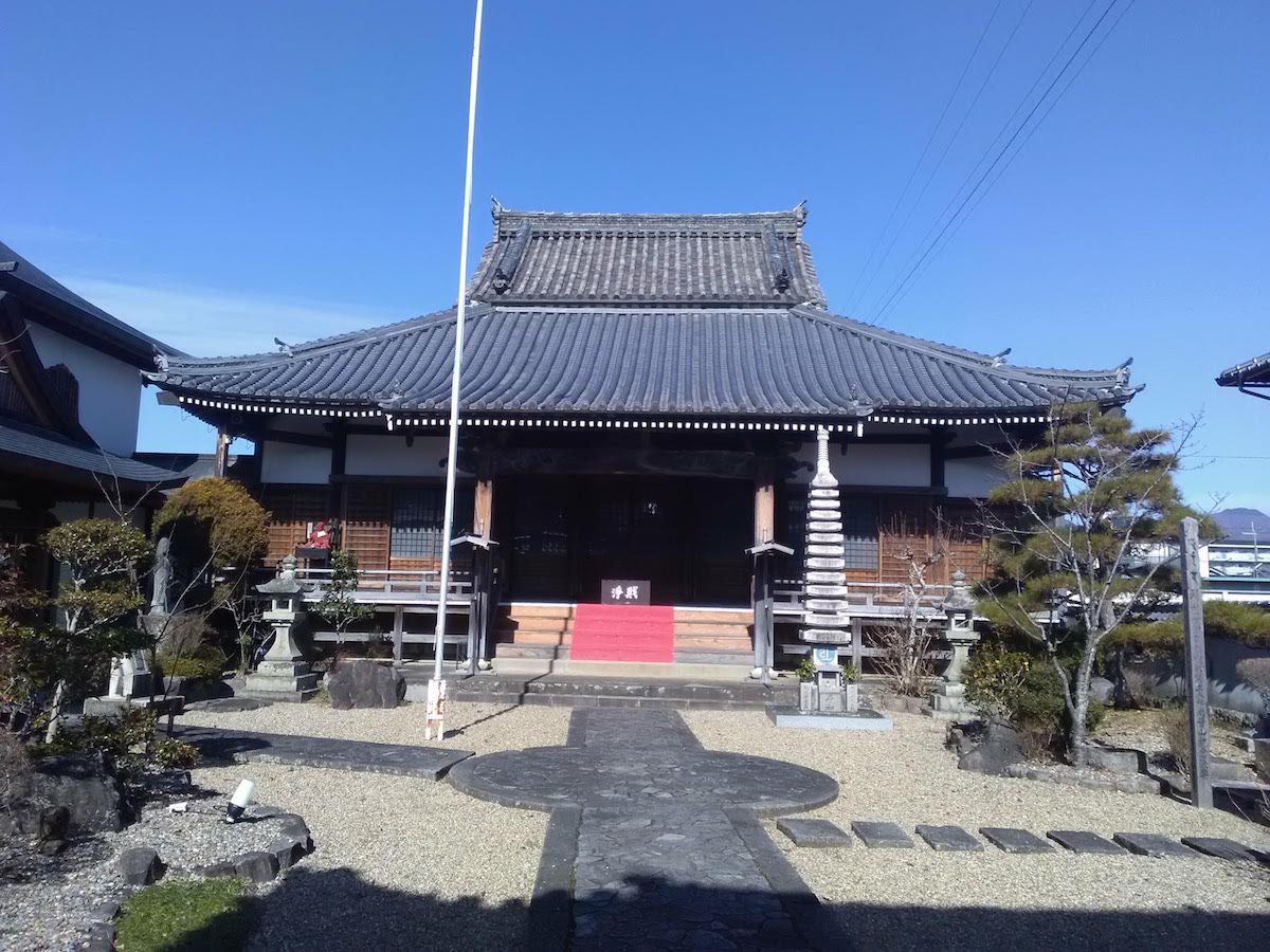
Sonpo-ji Temple
![]() Temple・Shrine
Temple・Shrine
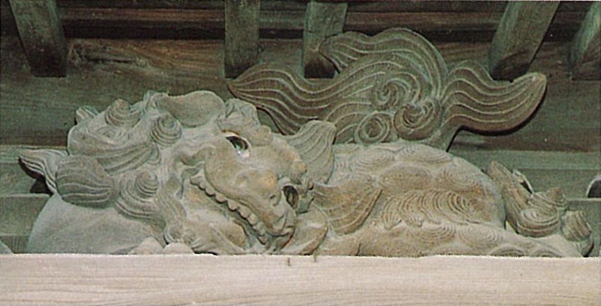
Sonpo-ji Temple was founded in February of the third year of the Eisho era (1506). Originally, it was a Buddhist temple of the Tendai school, but afterwards it was converted to the Jodo Shinshu school. It was deeply revered by the Hatano Clan, the Sengoku daimyos that ruled Taki County (which is almost where Sasayama City is now), and it had become a place of prayer for driving away bad luck from the unlucky direction of Yakami Castle. When Sasayama Castle was being constructed, it was removed and rebuilt in its present area with the same aim of driving away bad luck from the unlucky direction. Beneath the roof of the temple gate crouches a lion made of wood. When Tatsumachi was struck by a great fire on February 18th in the fourth year of the Bunka era (1807), the temple caught fire and burned down, but only the temple gate remained despite being engulfed by raging flames. Due to it being so strange, it has been said that "That lion blew out the flames." It is a legend related to the lion that tells of excellent figure and expression (city-designated cultural property). Location:Tatsumachi 141
Kasuga Shrine
![]() Temple・Shrine
Temple・Shrine
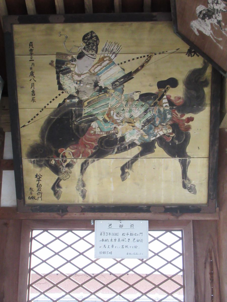
(1)Kasuga Shrine It is said that Kasuga Shrine began when the Fujiwara Clan, which had Hikisho as its fiefdom in the years of the Jogan era at the start of the Heian period (859-877), carried out kanjo (which refers to newly inviting Buddhas or deities to temples or shrines) from where their patron deity was in Kasuga Grand Shrine of Yamato Province (now Nara Prefecture) to the land of Sasayama (which is now the hill where Sasayama Castle is). In the 14th year of the Keicho era (1609), it was moved to its present area in Kurooka due to Sasayama Castle being constructed in Sasayama. (2)The Noh Stage The Noh stage is in the shrine grounds of Kasuga Shrine, and it was donated and constructed in the first year of the Bunkyu era (1861) by Tadanaga Aoyama, the 13th feudal lord of the Sasayama Domain who was known as a fan of Noh plays. It is an elaborate make in accordance with the ideas of the feudal lord, and pines are depicted on the kagami-ita for the stage background, and giant Tamba ware pots are placed beneath the floor in order to have the sounds of stepping on the floorboards echo. It was said to have been the grandest Noh stage in the west, more than that of Hakone. It is still used as a Noh stage today, and every year in January, the New Year's Noh, "Okina," is held, and in April, the "Kasuga Noh" is held. In the 15th year of the Heisei period (2003), it was designated as an important cultural property of the country as "one of the best early modern Noh stages in western Japan that is genuine and with excellent decorations as well." (3)Ema①The Kuroshinme no Ema Plaque The ema plaque that was dedicated in the second year of the Keian era (1649) by Tadakuni Matsudaira, the third feudal lord of the Sasayama Domain, when he moved to Akashi due to tenpo, and it is hung in the Ema Plaque Hall of Kurooka Kasuga Shrine. It is a beautiful piece said to have been painted by the brush of Naonobu Kano, one of the painters of the Kano school who was active in the Edo period. From that powerful style of painting, there is a story saying that as the black sacred horse would escape from the painting and devour the beans of the field, wire netting was stretched across to stop it from coming out of the painting (city-designated cultural property).Hikoshichi Oomori Ema Plaque An ema plaque titled, "Illustration of Hikoshichi Oomori Being Troubled By Souls of the Men of Nancho." Hikoshichi Oomori was a retainer of Takauji Ashikaga, who established the Muromachi Shogunate, and as retribution for forcing Masahige Kusunoki to commit seppuku in the Battle of Minatogawa, he was troubled by the souls of the men of Nancho, who they were fighting against. This ema plaque was painted with that legend (Taiheiki) as the foundation (city-designated cultural property). Location:Kurooka 75
Honkyo-ji Temple
![]() Temple・Shrine
Temple・Shrine
Honkyo-ji Temple is a Buddhist temple of the Nichiren school constructed in the sixth year of the Keicho era (1601) in Tsuchiura, Hitachi Province (which is where Tsuchiura City, Ibaraki Prefecture is now), and when the second lord of Sasayama Castle of the Sasayama Domain, Nobuyoshi Matsudaira moved to Sasayama due to tenpo (referring to when daimyos move domains) in the fifth year of the Genna era (1619), the temple moved from Tsuchiura to its present area. Moreover, fossils of crawl marks of shells have been left in the temple grounds, which tells of how this whole area was wetlands at the time (city-designated natural monument). Location:Kawaramachi 92
 Culture
The Old Tamba Pottery Museum was built in the 12th year of the Meiji period (1880), and at the time, it was used as a rice granary of a money-exchange store. It is a building with a distinctive storehouse on each side of the gate. The Old Tamba Collection is a group of Tamba ware works that are housed and displayed in the Old Tamba Pottery Museum, and refers to 312 pieces with especially high artistic value, even among the pieces made from the Heian period to the end of the Edo period (Hyogo Prefectural designated cultural property). Location:Kawaramachi 185
Oujiyama Pottery
![]() Culture
Culture
The beginning of Oujiyama ware goes back to the first year of the Bunsei era (1818), and it is said that its origin was when Tadayasu Aoyama, the 12th feudal lord of the Sasayama Domain, invited Kamesuke Kinkodo, who was known as a skillful artisan of Kyo ware, to the Oujiyama area (Kawaramachi, Sasayama City) and started a Domain Kiln (a kiln managed by the Domain). From the time the kiln was constructed, it obtained fame as the Oujiyama Pottery, but its tradition ceased since the closing of the kiln in the second year of the Meiji era (1870) alongside the abolishment of the Domain. The present Oujiyama Pottery is the one that had been restored by what was Sasayamacho at the time in the 63rd year of the Showa period (1988) near the location where the original pottery was. Even now, it is producing Oujiyama ware that faithfully recreates the techniques of that time. Location:Kawaramachi 431 Oujiyama Pottery Place Official Home PageHP:http://www.withsasayama.jp/ojiyama/