Kyoto (1467-1592)
備考<br> ・折りたたみ25x18cm<br> ・明治34年2月10日印刷 仝年2月18發行<br> ・「寶暦3年癸酉正月24日」<br> 表紙に「百四十冊ノ内第百三十五號」とあり
All spots information
9 spots
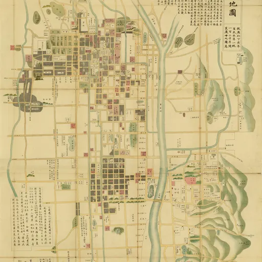
 Old Maps of ancient Kyoto
The current Imperial Palace
![]() Old Maps of ancient Kyoto
Old Maps of ancient Kyoto

Dai-dairi the Heian Capital, was used as one of the temporary imperial palace and at the time devastated by war.Was promoted to be used continuously from the 14th century palace.
Shinsen-en
![]() Old Maps of ancient Kyoto
Old Maps of ancient Kyoto

Heian-kyo capital the same time, the garden was built for the emperor to the south of Heian-kyo Dai-dairi. This was the prototype of the Gion Festival and Spirit Association.
Central location that serves as the capital.For political change, and accidental fire, but burned down repeatedly, most destroyed by fire in 1227. Currently, the Heian Shrine Daigokuden has been restored and more Oote-mon.
Heian period, one after the abdication of the Imperial Palace the Emperor lived. Horse viewing party was held and poetry. Repeated fires and devastation currently only have a stone.The Tale of Genji, also spent the later half-brother of Mr Suzaku emperor abdicated.
The gates were poised at the southern end of Suzaku highway, Main gate of the city's de facto peace
796, one of the first temple was built in the national Kyoto's imperial prayer of the Emperor Kammu. The building was rebuilt after all, they remain the size of the deployment period Heian-kyo."Historic Monuments of Ancient Kyoto" World Heritage Site as.
796, the National Cathedral, along with To-ji Temple in Kyoto's built by the emperor's imperial prayer Kanmu.
East market
![]() Old Maps of ancient Kyoto
Old Maps of ancient Kyoto
Heian-kyo was established in two locations, one of Official market. Sell wheat and cotton cloth wooden pot horses. Located east of the city was the golden age Sakyo 10th century development.
West market
![]() Old Maps of ancient Kyoto
Old Maps of ancient Kyoto
Heian-kyo was established in two locations, one of Official market. Soybean and cotton, silk and linen selling pottery cow. Became obsolete since the mid-Heian period.