DIG THE LOCAL IN KANSAI
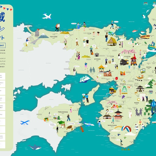
DIG THE LOCAL IN KANSAIとは、一般財団法人関西イノベーションセンター、一般財団法人関西観光本部、そして株式会社Strolyによる3社連携のプロジェクトです。 関西エリアを中心とした2府8県の観光情報を集約し、広域観光マップとして公開することで、関西の観光地をより多くの人々に知ってもらい、新しい場所の魅力を発見してもらうことを目的としています。 直感的に情報を得られるイラストデジタルマップはそれぞれの観光地の特色を生かしたデザインで、観光スポットを視覚的に楽しむことができます。あなたにとってお気に入りのマップを見つけ、様々な魅力あふれる関西を是非探訪してみてください。
 Posted byMUIC Kanasi更新日:
 すべてのスポット情報
99件のスポット
 大阪府
大阪府

^TOP この場所に行ってみたい このマップを見る 大阪市 水都大阪 中之島まちあるきマップ 水都大阪の象徴的スポットである「中之島」の魅力を詰め込んだマップです。大阪の水辺の見どころスポットが表示されますので、水辺のまちあるきにご活用ください。 経路を探す(Google Maps) 体験スポット(大阪市)

^TOP この場所に行ってみたい このマップを見る 大阪市 Universal Taste of OSAKAFood Pict Restaurant MAP 天下の台所として有名な大阪の中心地、北エリア(梅田周辺)と南エリア(心斎橋エリア)の飲食店を紹介するマップです。代表メニューの材料を掲載し、食の多様性に配慮したマップです。 経路を探す(Google Maps) 体験スポット(大阪市)

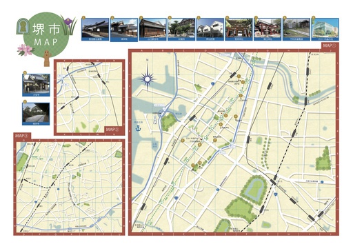
^TOP この場所に行ってみたい このマップを見る 大阪府 堺市 レトロ和菓子めぐりマップ(環濠エリア) チンチン電車がのんびりと路面を走る、堺市内の環濠エリア。ここには、かつて築かれた環濠によって、独自の文化が花開いた歴史があります。千利休屋敷跡からの和菓子巡り、あるいは、与謝野晶子ゆかりのお寺巡りなど、世界につながる自治都市だった堺のカルチャーをじっくり満喫できるエリアです。純喫茶や昔ながらの銭湯で小休憩しながら、シェアサイクルでの移動もオススメです。 経路を探す(Google Maps) 体験スポット(堺市)
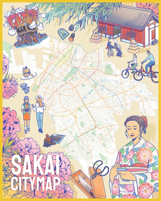
^TOP この場所に行ってみたい このマップを見る 大阪府 堺市 堺市全域マップ 堺市全域の観光スポットをはじめ、宿泊、グルメ、お土産などの情報を多数紹介しているスタンダードなマップです。スマートフォンやタブレットなどのGPSを使って堺市を探訪してください。 経路を探す(Google Maps) この場所に行ってみたい このマップを見る 大阪府 堺市 古墳ぶらりマップ(大仙公園エリア) 大阪・堺市にある百舌鳥古墳群は、日本を代表する古墳群。かつては100基以上あったといわれ、現在も44基が残っています。 主な古墳は、大仙公園を挟んで、日本最大の前方後円墳・仁徳天皇陵古墳と履中天皇陵古墳、東側にいたすけ古墳、御廟山古墳、ニサンザイ古墳、北側に反正天皇陵古墳があります。「百舌鳥・古市古墳群」として、2019年に大阪初の世界遺産に登録されています。 経路を探す(Google Maps) 体験スポット(堺市)
^TOP この場所に行ってみたい このマップを見る 大阪府 堺市 伝統文化体験マップ 堺の伝統産業や神社仏閣などを見学・体験できる体験型メニューを掲載。サイト上で予約・決済いただけます。 経路を探す(Google Maps) 体験スポット(堺市)
^TOP この場所に行ってみたい このマップを見る 大阪府 大阪狭山市 さやまのええもん・ええとこマップ さやまのええもん や、ええとこ をぎゅっと詰め込んだマップです。実際に大阪狭山市を歩いて、魅力に触れてみてください♪ 経路を探す(Google Maps) 体験スポット(大阪狭山市)

^TOP この場所に行ってみたい このマップを見る 大阪府 岸和田市 岸和田城周辺まち歩きマップ 江戸時代のはじめに城下町として栄えた城郭や、紀州街道沿いの古いまちなみ。大正、昭和へと紡績などで発展した面影が残る、個性的な建築物の数々・・・だんじり祭とともに素晴らしいものを残してきた、岸和田城下町の人々。和菓子やご当地グルメ、岸和田の郷土食に挑戦。祭礼衣装、だんじりグッズに納得!そして、寺社仏閣、建築物、資料館などをぶらぶら再発見してみませんか? 経路を探す(Google Maps) 体験スポット(岸和田市)
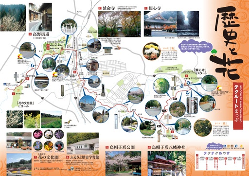
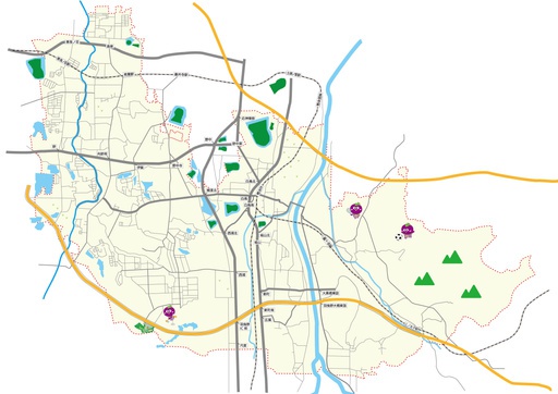
^TOP この場所に行ってみたい このマップを見る 大阪府 河内長野市 河内長野市 テクルートマップ歴史と花コース 河内長野市の観光デジタルマップです。観光スポットや、GPSを使った現在地情報が表示され、バーチャルな観光体験が可能です。豊かな自然と歴史、文化が今に息づく河内長野をご堪能ください。 経路を探す(Google Maps) 体験スポット(河内長野市)
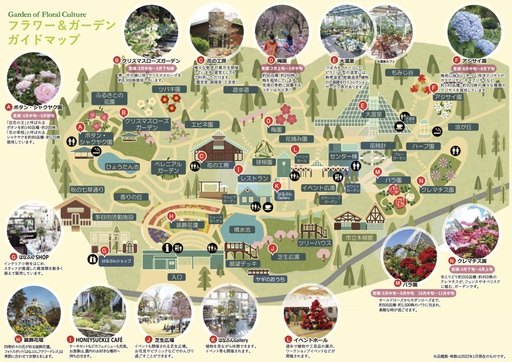
^TOP この場所に行ってみたい このマップを見る 大阪府 河内長野市 大阪府立 花の文化園 バラ園やクレマチス園、ボタン園、クリスマスローズガーデン等、季節ごとの花が咲く各種ガーデンに加え、一年を通して見どころに溢れた大温室といった充実したガーデンをお楽しみいただけます。 経路を探す(Google Maps) 体験スポット(河内長野市)
^TOP この場所に行ってみたい このマップを見る 大阪府 羽曳野市 羽曳野市観光マップ 大阪府の南河内に位置する羽曳野市内の観光スポットやレジャー施設など、見どころが詰まったマップです。世界遺産と日本遺産のあるまち羽曳野を、是非お楽しみください。 経路を探す(Google Maps) 体験スポット(羽曳野市)
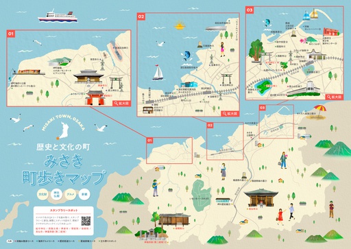
^TOP この場所に行ってみたい このマップを見る 大阪府 岬町 歴史と文化の町 みさき町歩きマップ 文化財や古墳など、歴史あふれるみさき町の町をゆっくり歩いて散策してみませんか? 経路を探す(Google Maps) 体験スポット(岬町)
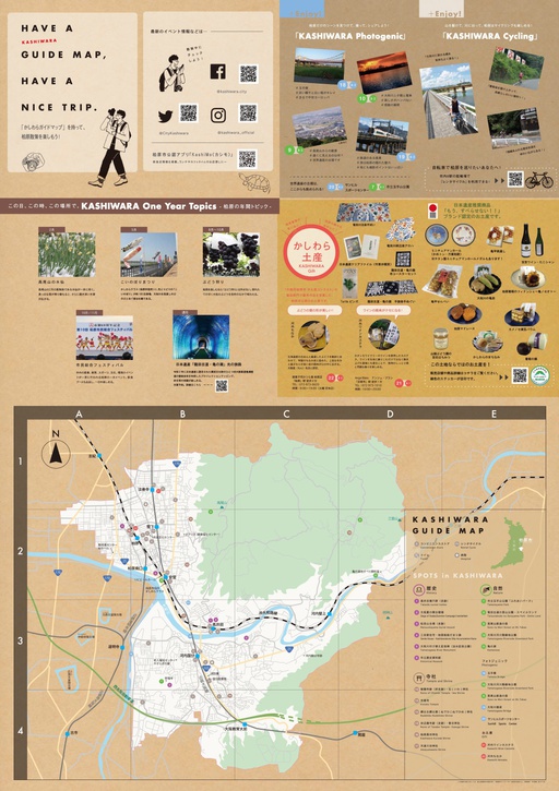
^TOP この場所に行ってみたい このマップを見る 大阪府 柏原市 かしわらガイドマップ 大阪府柏原市の観光デジタルマップです。かしわらの“WA”。“WA”。それは、発見したり、笑顔になったり、感動したり。心が動く瞬間に、思わず声に出てしまう言葉。柏原は、そんな“WA”となる場所やコト・モノ・ヒトに、沢山出逢える素敵な街です。奥深い歴史から豊かな自然、物語のある寺社。そして、写真に撮りたくなる美しいスポットや気持ちよく走りたくなるサイクリングコースに四季折々のイベントや多彩なお土産まで。このガイドマップをみて、柏原市をすみずみまで楽しんで喜びの輪を広げてください。 経路を探す(Google Maps) 体験スポット(柏原市)

この場所に行ってみたい このマップを見る 大阪 万博記念公園自然文化園・日本庭園マップ 大阪府吹田市にある1970年日本万国博覧会の跡地に整備された「万博記念公園」の自然文化園・日本庭園エリアデジタルマップです。 当マップ上では、自然文化園・日本庭園エリア内の観光スポットや施設に関する情報が表示されるほか、GPSを使った現在地情報の表示、マップの切替などができ、バーチャルな観光体験が可能です。 経路を探す(Google Maps) 体験スポット(吹田市)

この場所に行ってみたい このマップを見る 大阪府 三島郡 山崎蒸溜所エリアファクトリップMAP ファクトリップMAPは、サントリー工場のある地域の魅力を楽しむためのツールです。観光・グルメ・お買い物など、工場見学の前後におすすめスポットを巡れば、ファクトリーを巡る旅=ファクトリップがより楽しくなること間違いなし!工場フタッフのおすすめスポットも掲載していますのでぜひご活用ください。 経路を探す(Google Maps) 体験スポット(三島郡)
中之島パビリオンフェスティバル2025 ^TOP この場所に行ってみたい このマップを見る 大阪市 中之島パビリオンフェスティバルマップ 中之島パビリオンフェスティバル2025開催期間中のイベントや各パビリオンである施設情報を紹介するマップです。中之島には、美術館やコンサートホールなどの世界水準の施設、そして水辺の空間など素敵なエリアが沢山!是非マップを活用しながら、各イベントや施設を訪れ、中之島が誇る文化芸術を思いっきり満喫しよう! 経路を探す(Google Maps) 体験スポット(大阪市)
 京都府
京都府

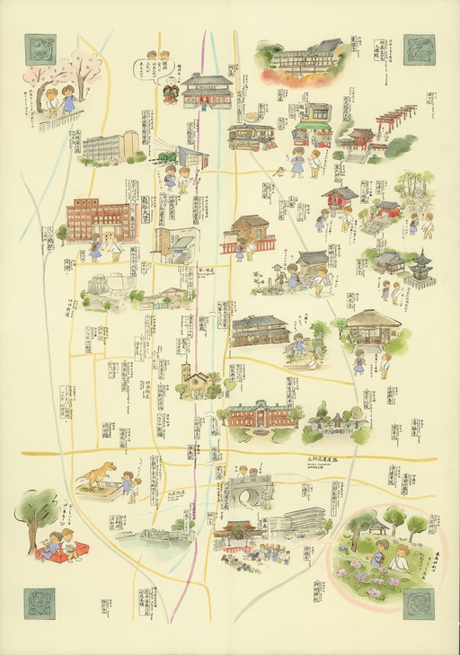
^TOP この場所に行ってみたい このマップを見る 京都市 京歩きマップ 「京歩きマップ」は京都観光NAVIの公式マップです。京都観光に便利なイラストマップの中を位置情報付きで散策していただけます。京都市内の観光にご活用ください。 経路を探す(Google Maps) 体験スポット(京都市)

^TOP この場所に行ってみたい このマップを見る 京都市 京都市内天然温泉マップ 京都散策に+温泉。心と体を癒し、潤すひととき。京都市温泉観光活性化協議会では、市内加盟施設を掲載した京都市内天然温泉マップを公開しています。 経路を探す(Google Maps) 体験スポット(京都市)
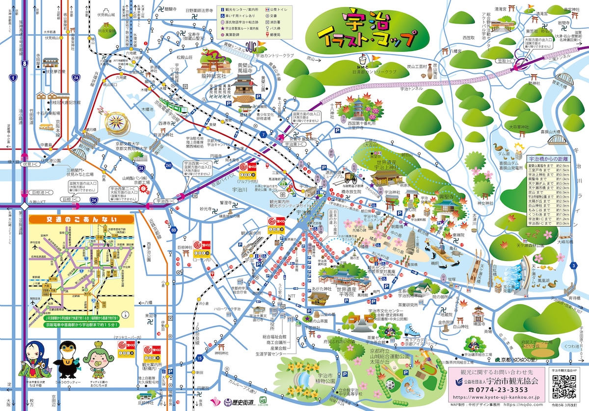
^TOP この場所に行ってみたい このマップを見る 京都府 宇治市 宇治イラストマップ 宇治のおすすめスポットをイラストマップで紹介しています。名産品である宇治茶に加え、蕎麦や和菓子、お土産屋さんも紹介しております。 経路を探す(Google Maps) 体験スポット(宇治市)

^TOP この場所に行ってみたい このマップを見る 京都府 宮津市 天橋立散策マップ 海の京都エリアにある日本三景天橋立の観光デジタルマップを公開しています。マップ上では、天橋立周辺の観光スポット情報や飲食、お土産店などが表示されるほか、GPSを使った現在地情報の表示、マップの切り替えが可能です。 経路を探す(Google Maps) 体験スポット(宮津市)

^TOP この場所に行ってみたい このマップを見る 京都府 美山町 美山町アクセスマップ かやぶきの里で有名な京都府美山町の観光マップです。公園や神社、資料館、美術館など美山町の自然と歴史を体験できるスポットを紹介しています。 経路を探す(Google Maps) 体験スポット(美山町市)
^TOP この場所に行ってみたい このマップを見る 京都市 伏見区 世界遺産 京都・醍醐寺境内マップ 京都の世界文化遺産に登録されている醍醐寺は真言宗醍醐派の總本山で、 太閤秀吉による「醍醐の花見」でも有名な古刹です。京都府下で最も古い木造建築物である五重塔をはじめ、 7万5千点あまりの国宝を含む寺宝・伝承文化財は約15万点におよびます。桜や紅葉も美しい醍醐寺の見どころをデジタルマップにまとめました。 経路を探す(Google Maps) 体験スポット(京都市)
^TOP この場所に行ってみたい このマップを見る 京都市 京都・梅小路おさんぽマップ 梅小路エリアのグルメ、観光、その他もろもろ魅力の詰まったデジタルマップを公開!駅が開業し、大型ホテルや商業施設の開発が進み、市場や商店街などの昔ながらのものと新しいものが混在して新しい街に生まれ変わろうとしています。地元の皆さんから観光客まで、デジタルマップを見ながら梅小路エリアを楽しもう! 経路を探す(Google Maps) 体験スポット(京都市)

^TOP この場所に行ってみたい このマップを見る 京都市 京都のれん会マップ 京都市内の名産品を網羅的にご紹介するイラストマップです。可愛らしい動物たちが京都の名産品と出逢いながら、歴史めぐりで観光を楽しんでいます。 経路を探す(Google Maps) 体験スポット(京都市)
祇園祭デジタルマップ
![]() 京都府
京都府
^TOP この場所に行ってみたい このマップを見る 京都市 前祭 祇園祭デジタル絵地図2023 このマップは京都新聞社とStrolyでコラボレーションを行い、祇園祭を現地でも、おうちでも楽しめる祇園祭マップを作成しました。マップ部分は完全手描きでの描き下ろし作品となり、「鳥獣戯画」を彷彿とさせる、個性豊かなキャラクターたちが祇園祭を楽しむ様子をご覧いただけます。スポット情報では、京都新聞社提供の祇園祭に登場する各山鉾の情報はもちろん、祇園祭に関連する主要な神事や行事についてもご紹介。7月1日から31日まで開催される祇園祭を、余すことなくお届けします。 経路を探す(Google Maps) この場所に行ってみたい このマップを見る 京都市 後祭 祇園祭デジタル絵地図2023 このマップは京都新聞社とStrolyでコラボレーションを行い、祇園祭を現地でも、おうちでも楽しめる祇園祭マップを作成しました。マップ部分は完全手描きでの描き下ろし作品となり、「鳥獣戯画」を彷彿とさせる、個性豊かなキャラクターたちが祇園祭を楽しむ様子をご覧いただけます。スポット情報では、京都新聞社提供の祇園祭に登場する各山鉾の情報はもちろん、祇園祭に関連する主要な神事や行事についてもご紹介。7月1日から31日まで開催される祇園祭を、余すことなくお届けします。 経路を探す(Google Maps) 体験スポット(京都市)
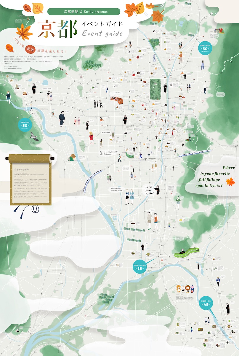
^TOP この場所に行ってみたい このマップを見る 京都市 京都イベントガイド 京都のイベント情報が一目でわかるデジタルマップです。 老舗和菓子店をテーマにしたマップイラスト上で、京都市内で開催されるイベント情報も随時追加します! 美味しい和菓子や京都の季節を感じながら、気になるイベントやスポットを余すことなくご堪能ください。 (マップデザイン制作:Stroly Inc./イベント・情報提供:京都新聞社 経路を探す(Google Maps) 体験スポット(京都市)
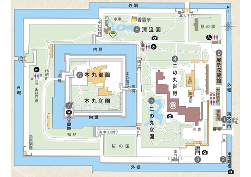
^TOP この場所に行ってみたい このマップを見る 京都府 京都市 二条城マップ 二条城は京都市中京区に位置する歴史的な城で、1603年に徳川家康が築城しました。江戸時代初期の武家政権の象徴であり、豪華な二の丸御殿や美しい庭園が見どころです。また、1867年に大政奉還が行われた場所としても有名です。1994年には世界遺産に登録され、日本の歴史と文化を学ぶ貴重なスポットを紹介しています。 経路を探す(Google Maps) 体験スポット(京都市)

^TOP この場所に行ってみたい このマップを見る 京都市 映画村村内マップ 太秦映画村のマップです。江戸時代の街並みやアトラクションが点在し、時代劇のセットや体験型アクティビティが楽しめます。忍者や侍ショーも見どころです。 経路を探す(Google Maps) 体験スポット(京都市)
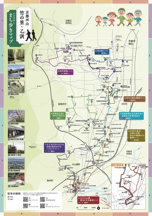
^TOP この場所に行ってみたい このマップを見る 京都府 長岡京市付近 京都西山 竹の里・乙訓 ~いとをかし まち歩きマップ~ 京都西山 竹の里・乙訓は、嵐山から続く西山連峰の麓に広がる、千年以上の歴史を持つ竹の名所で、「京たけのこ」の産地です。桓武天皇が長岡京を築き、山崎の合戦の舞台にもなった歴史的な地で、向日神社や長岡天満宮などの社寺仏閣を巡る8つの観光コースがあります。桜や紅葉など四季折々の自然も楽しめます。 経路を探す(Google Maps) 体験スポット(長岡京市)

この場所に行ってみたい このマップを見る 京都府 長岡京市 ファクトリップMAP(〈天然水のビール工場〉京都エリア) ファクトリップMAPは、サントリー工場のある地域の魅力を楽しむためのツールです。観光・グルメ・お買い物など、工場見学の前後におすすめスポットを巡れば、ファクトリーを巡る旅=ファクトリップがより楽しくなること間違いなし!工場フタッフのおすすめスポットも掲載していますのでぜひご活用ください。 経路を探す(Google Maps) 体験スポット(長岡京市)
^TOP この場所に行ってみたい このマップを見る 京都市 深草・稲荷まちあるきマップ 龍谷大前深草駅周辺にある龍谷大学の学生が伏見稲荷大社もある周辺の見どころを調べて紹介しています。 龍谷大学生がランチに行くお店もあり、ぜひ一度足を運んでください。 経路を探す(Google Maps) 体験スポット(京都市)
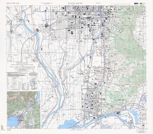
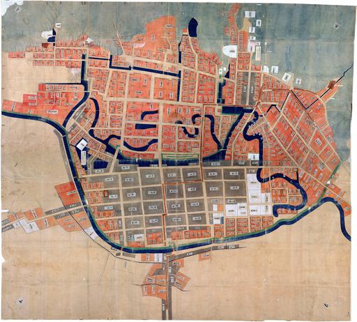
^TOP この場所に行ってみたい このマップを見る 京都市 米軍地図:京都市南 (1945) アメリカ軍が終戦直後に制作した京都府京都市南部の地図。 経路を探す(Google Maps) 体験スポット(京都市)
 兵庫県
兵庫県

^TOP この場所に行ってみたい このマップを見る 兵庫県 ひょうご全域マップ 兵庫県全域を網羅した観光スポットを紹介する地図です。神戸の洗練された街並みや兵庫の自然豊かな風景、姫路城の壮麗な姿など、多彩な魅力が詰まった地域を探索できます。食、歴史、文化、自然など、様々な要素を是非楽しんでください。 経路を探す(Google Maps) 体験スポット(兵庫県全域)
^TOP この場所に行ってみたい このマップを見る 兵庫県 神戸市 神戸観光マップ 神戸市内主要エリアの観光施設をまとめたデジタルマップです。「三宮・元町・神戸エリア」、「北野・新神戸エリア」、「港・ハーバーランドエリア」にある観光施設や各エリアの観光案内所をピックアップし、各スポットの観光情報を掲載しています。どのエリアも神戸の魅力がつまっているので、GPSで位置情報を確認しながら散策していただき、神戸を堪能してください。 経路を探す(Google Maps) 体験スポット(神戸市)
^TOP この場所に行ってみたい このマップを見る 兵庫県 尼崎市 尼さんぽグルメマップ 大阪から電車で7分。尼崎城の建つ阪神尼崎駅周辺は、阪神タイガースの応援で有名な商店街や閑静なお寺の立ち並ぶ寺町などがあり、まちあるきにぴったり。このマップでは、阪神尼崎駅・出屋敷駅周辺の飲食店情報を掲載しています。(飲食店の営業時間などの変更が反映できていない場合がございます。最新の情報は、各公式サイトなどからご確認ください) 経路を探す(Google Maps) 体験スポット(尼崎市)
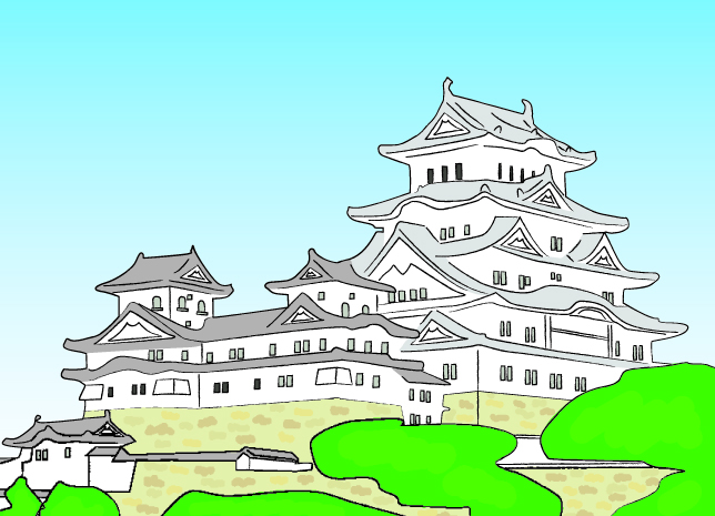
^TOP この場所に行ってみたい このマップを見る 兵庫県 姫路市 姫路まんきつイラストマップ 姫路市の観光情報がひと目でわかる! 経路を探す(Google Maps) この場所に行ってみたい このマップを見る 兵庫県 姫路市 姫路まんきつイラストマップ(家島諸島編) 家島諸島の観光情報がひと目でわかる! 経路を探す(Google Maps) この場所に行ってみたい このマップを見る 兵庫県 姫路市 姫路市古地図 姫路の古地図で姫路の町を探検してみよう 経路を探す(Google Maps) 体験スポット(姫路市)

^TOP この場所に行ってみたい このマップを見る 兵庫県 高砂市 タイムスリップ 高砂町おさんぽマップ 江戸、明治の街並みを行く ふらりまち歩き 高砂ノスタルジア江戸時代から続く港町、高砂は今も当時の風景を残しています。タイムリップしたかのように思える街並みを、Strolyデジタルマップで町名看板を辿りながら、旧跡を巡ってください。ノスタルジックでのんびりゆったりした時間が流れる高砂でふらりまち歩きを楽しみませんか。 経路を探す(Google Maps) 体験スポット(高砂市)
^TOP この場所に行ってみたい このマップを見る 兵庫県 高砂市 結びのまち高砂市まっぷ 新郎新婦が着座する席のことを「高砂の席」と呼ぶようおめでたい言葉の総称として使われている「高砂」発祥の地で、古来より結びに関する伝承が多く残されています。近年は「宮本武蔵」の生誕地のひとつとして注目も集めています。パワーストーンで日本三奇のひとつでもある石の宝殿など歴史、結び、奇跡が詰まった市です。 経路を探す(Google Maps) 体験スポット(高砂市)
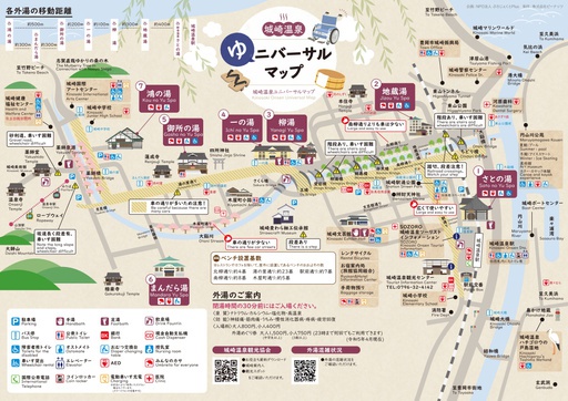
^TOP この場所に行ってみたい このマップを見る 兵庫県 豊崎市 城崎町 城崎温泉ゆニバーサルマップ 城崎温泉をどんな方でも楽しんでいただけるよう作成されたマップです。 経路を探す(Google Maps) 体験スポット(城崎温泉)
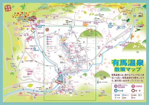
^TOP この場所に行ってみたい このマップを見る 兵庫県 神戸市 北区 有馬温泉 有馬温泉散策マップ 有馬温泉には、様々なグルメやお土産もいっぱい。有馬温泉街を観光しながら、旅の思い出を作ってくださいね。 経路を探す(Google Maps) 体験スポット(有馬温泉)
^TOP この場所に行ってみたい このマップを見る 兵庫県 灘五郷 灘五郷 酒蔵巡りマップ 日本一の酒どころ「灘五郷」のデジタルイラストマップ。マップ上では「灘五郷」エリア内の酒蔵に関する情報が表示されるほか、GPSを使った現在地の情報、マップの切替などができます。イラストマップを見ながら現地を回り、酒蔵巡りを楽しむことができます。 経路を探す(Google Maps) 体験スポット(灘五郷)
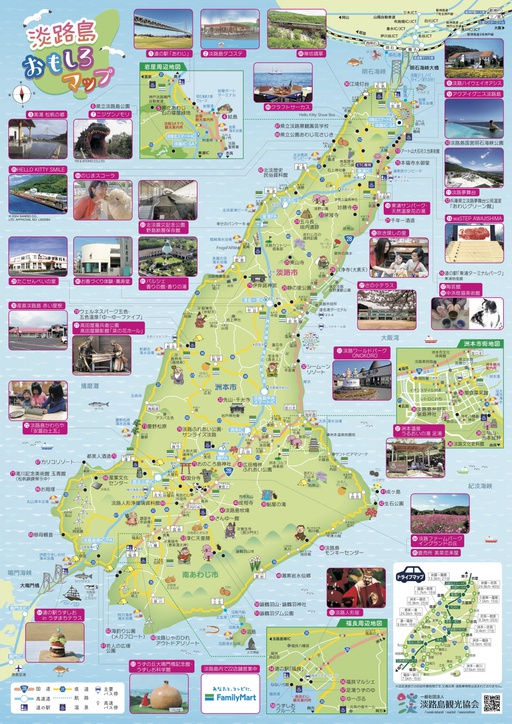
^TOP この場所に行ってみたい このマップを見る 淡路島, 兵庫県 淡路島 おもしろマップ 淡路島の観光スポットや名所を紹介しています。 美味しいものを食べながら、見どころをぜひ巡って、淡路島を満喫してください。 経路を探す(Google Maps) 体験スポット(淡路島)
 奈良県
奈良県

^TOP この場所に行ってみたい このマップを見る 奈良県 奈良市 奈良公園ウォークマップ 世界遺産「古都奈良の文化財」を巡ろう奈良公園は、歴史と自然が調和する日本有数の観光名所です。広大な敷地には奈良時代の文化遺産である多くの寺院や史跡が点在し、特に鹿との共存が有名です。奈良時代に始まる歴史的建造物や仏像、美しい庭園などが訪れる人々を魅了します。また、四季折々の美しい自然も楽しめ、春には桜、秋には紅葉が見事な風景を演出します。奈良公園内の散策路を歩きながら、古都ならではの風情を感じてみてください。*奈良公園の鹿たちは草食動物で芝や木の実を食べています。鹿せんべいは、鹿たちにとって安全なおやつです。お菓子や野菜や紙などを食べるとお腹をこわすので与えないでください。 経路を探す(Google Maps) 体験スポット(奈良市)

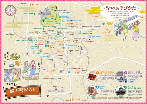
^TOP この場所に行ってみたい このマップを見る 奈良県 大和郡山市 城下町ぶらっと散策マップ 江戸時代からの歴史を持ち、全国有数の金魚の生産地でもあり、はかなくも美しい桜が咲き誇る大和郡山市の情緒あふれる城下町をお気軽に散策いただけるマップです。 経路を探す(Google Maps) 体験スポット(大和郡山市)

^TOP この場所に行ってみたい このマップを見る 奈良県 桜井市 桜井市全域詳細マップ 奈良県中部に位置する桜井市の観光スポットを網羅的にご紹介するマップです。現存最古の和歌集「万葉集」ゆかりの地としても知られ、日本古来の遺跡である古墳が数多く現存しています。 経路を探す(Google Maps) 体験スポット(桜井市)
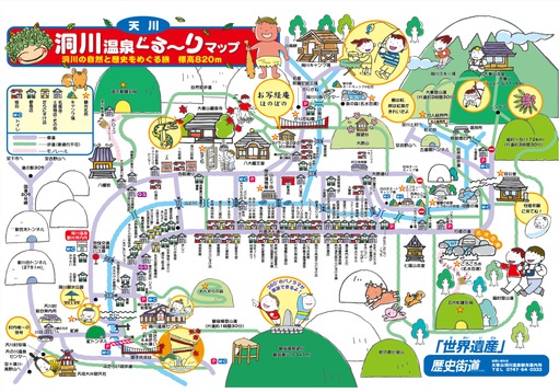
^TOP この場所に行ってみたい このマップを見る 奈良県 吉野郡 洞川温泉ぐるっとまっぷ 洞川の自然と歴史をめぐる旅 標高820m奈良県吉野郡天川村に位置する洞川温泉は、美しい山々に囲まれた自然豊かな温泉地です。源泉かけ流しの温泉で、心も体も癒されること間違いなし。温泉街には趣の異なる多彩な宿が点在し、露天風呂からは四季折々の景色を楽しめます。また、温泉周辺には散策路や展望台があり、美しい景色を眺めながらの散策もおすすめです。地元の料理や特産品も堪能でき、リフレッシュしたい方には最適なスポットです。 経路を探す(Google Maps) 体験スポット(吉野郡)
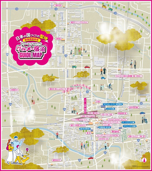
^TOP この場所に行ってみたい このマップを見る 奈良県 桜井市 奈良県桜井市・マッシュアッププロジェクト マッシュ・アップとは、「複数の曲を組み合わせて、新しい曲をつくること」を意味する 音楽用語。私たちマッシュアッププロジェクト実行委員会では、JR・近鉄「桜井駅」 周辺エリアにある飲食店と宿泊施設が協同しながら、それぞれの個性やスキルを マッシュアップすることで、これまでなかった新しい食の価値や魅力を創造し、 地域一体型グルメエンターテイメントの街づくりを目指します。 これにより新しい観光資源として桜井の街の魅力を高めるとともに、地域に お住まいの皆様には新しい食の楽しみ方や地域交流の場をご提供します。 また、地産地消の推進や食育イベントの開催など社会活動にも取り組んでいきます。 すべてはみんなのワクワクと地域の活性化のために! 経路を探す(Google Maps) 体験スポット(桜井市)
^TOP この場所に行ってみたい このマップを見る 奈良県 奈良市 ようこそ奈良へ観光マップ 奈良市の広域観光デジタルマップです。「古都奈良の文化財」として世界遺産に登録されている8資産を中心とした奈良市の観光スポットや施設に関する情報が表示されるほか、GPSを使った現在地情報の表示、特定の人とのマップ・現在地共有ができ、バーチャルな観光体験が可能です。 経路を探す(Google Maps) 体験スポット(奈良市)
^TOP この場所に行ってみたい このマップを見る 奈良県 奈良市 十輪院マップ 十輪院(じゅうりんいん)は奈良市にある歴史ある寺院で、奈良時代に創建されました。重要文化財の本堂には平安時代の仏像が安置され、静かで荘厳な雰囲気が漂います。奈良の観光スポットの一つとして知られ、奈良公園や東大寺へのアクセスも良好です。歴史や文化を感じながら、ゆっくりとした時間を過ごすのに最適な場所です。 このマップでは、十輪院の境内にある重要文化財の説明をしています。 経路を探す(Google Maps) 体験スポット(奈良市)
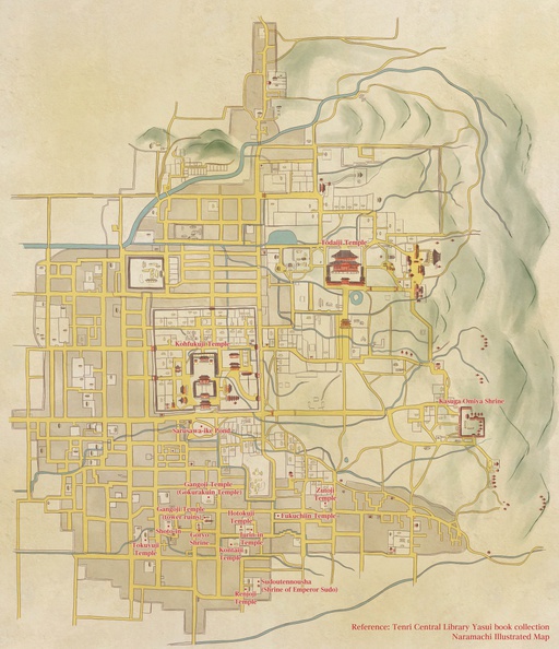
^TOP この場所に行ってみたい このマップを見る 奈良県 奈良市 奈良町寺社マップ(江戸時代再生古地図) 観光庁「令和4年度 地域独自の観光資源を活用した地域の稼げる看板商品の創出事業」を活用し、西日本広域観光連携文化財活用奈良推進協議会が行う実証実験として、奈良県奈良町エリアの観光マップを江戸時代の再生古地図で公開しています。マップ上では、GPSを使った奈良町エリアの寺社スポットを巡るデジタルスタンプラリーを行うことができます。 経路を探す(Google Maps) 体験スポット(奈良市)
^TOP この場所に行ってみたい このマップを見る 奈良県 奈良市 奈良町寺社スタンプラリーマップ 観光庁「令和4年度 地域独自の観光資源を活用した地域の稼げる看板商品の創出事業」を活用し、西日本広域観光連携文化財活用奈良推進協議会が行う実証実験として、奈良県奈良町エリアの観光マップを公開しています。 経路を探す(Google Maps) 体験スポット(奈良市)
 和歌山県
和歌山県

^TOP この場所に行ってみたい このマップを見る 和歌山県 紀の川市 フルーツの街 紀の川市周遊MAP どの季節に訪れても旬のフルーツに出会えるフルーツのまち、紀の川市。紀の川市周遊マップで旬のスポット情報を手に入れよう! 経路を探す(Google Maps) 体験スポット(紀の川市) 関西エリアパス ■JTRweb経由での販売■短期滞在の訪日外国人のお客様がご利用いただけるきっぷです。 ■自由周遊区間内の特急「はるか」号、普通列車(新快速・快速を含む)や西日本ジェイアールバスが1~4日間乗り放題です。 ※最大2列車まで特急「はるか」号の普通車指定席がご利用いただけます。■レンタサイクル「駅リンくん」もご利用いただけます。■京阪電鉄、京都市営地下鉄、阪急電鉄の1日乗車券の引換券も付随しています。 ホームページはこちら 関西ワイドエリアパス 訪日外国人向けの5日間有効のきっぷで、山陽新幹線や特急列車、普通列車、地方鉄道、バスが自由に利用できます。最大6本まで普通車指定席が利用可能で、事前予約が必要です。 ホームページはこちら 南海電鉄 観光列車 めでたいでんしゃ 臨時運行 南海電鉄の観光列車「めでたいでんしゃ」を貸切で、加太線(和歌山市駅~加太駅間)を臨時運行いたします。めでたいでんしゃは4編成(各2両)であり、「さち(ピンク色)」「かい(水色)」「なな(赤色)」「かしら(黒色)」あり、それぞれ特色のある観光列車となっています。 ホームページはこちら 関西空港リムジンバス乗車券 関西国際空港と各主要都市を乗り換え不要で直結! 空港へのアクセスに最適なリムジンバスです。 ホームページはこちら 紀の川エリア観光レンタサイクル 紀の川エリア(岩出市、紀の川市)において観光サイクリングを推進するため、主要駅前等ででレンタサイクルの貸出しをしています。また、各貸出窓口間で相互に返却できるワンウェイ返却サービスもあります。 ホームページはこちら 楽しい和歌山パス ■JTRweb経由での販売■複数の観光施設を1枚のQRコードで周遊できます。観光名所やグルメ、寺など多様な施設をお得に周遊できますので、是非ご利用ください! ホームページはこちら 無人島地ノ島サバイバルプラン 1日1組限定エリアの サバイバルキャンプ 「サバイバルプラン」は、専用エリアを貸し切ってキャンプができるプランです。定期船が発着するビーチとは別の場所で、チャーター船で乗り込みます。 ホームページはこちら 地ノ島キャンププラン 広大で自然豊かな無人島キャンプ 地ノ島では、広大で豊かな自然の中でキャンプができます!ビーチエリアや原っぱエリアからお好きなエリアを選んでいただけます。キャンプ道具のレンタルも可能!憧れの無人島キャンプを地ノ島でデビューしませんか。 ホームページはこちら 地ノ島日帰りBBQビーチプラン 青空の下、きれいな海を見ながらのビーチBBQは最高です。無人島・地ノ島ではBBQに必要な器材が全て揃ったセットプランもあるので、食材を持っていくだけで気軽にBBQができます!もちろん自分の器材がある人は持ち込みもOK。家族や仲間とビーチBBQが楽しめます! ホームページはこちら 和歌山電鐵貴志川線1日乗車券 和歌山電鐵貴志川線が1日乗り放題できる便利でお得なチケット。三毛猫の駅長が働く終点の貴志駅は猫型駅舎でカフェやグッズショップがあります。 ホームページはこちら 日本のアマルフィ雑賀崎で路地歩き体験 迷路のような細い路地道を経験豊富な地元ガイドのお話を聞きながら、灯台を目指して歩きます。斜面地の人々のあっと驚くような暮らしの工夫や地域の方々に見守られ、のんびり暮らす猫にもたくさん出会えます。 ホームページはこちら 観光ガイドの出来る乗務員が案内する貸切タクシーチャータープラン 和歌山市内、海南市内の最寄りの駅やホテルから出発! お客様のご希望によっては和歌山県下の観光ガイドも致します。 (事前連絡要) ホームページはこちら --> 黒潮市場のバイキングレストラン「ゴンドワナ」と紀州黒潮温泉のセットプラン 黒潮市場のバイキングレストラン「ゴンドワナ」での食事と紀州黒潮温泉の入浴がセットになったお得なプランです。和洋中の本格バイキング料理と絶景の天然温泉をお楽しみいただけます。 ホームページはこちら 関西・北陸エリアパス ●JTRwebでの販売●短期滞在の訪日外国人のお客様がご利用いただける きっぷです。●自由周遊区間内の北陸新幹線、山陽新幹線、特急列車、普通 列車(新快速・快速含む)、あいの風とやま鉄道、IRいしかわ鉄道、ハピライン ふくい、のと鉄道、京都丹後鉄道、和歌山電鐵、西日本ジェイアールバスが7 日間乗り放題です。●普通車指定席が何度でもご利用いただけます。(指定席 をご利用の際は、必ず事前に指定席を予約してからご乗車ください)●レンタサ イクル「駅リンくん」もご利用いただけます(おとなのみ)。 ホームページはこちら 関西・広島エリアパス ●JTRwebでの販売●短期滞在の訪日外国人のお客様がご利用いただけるきっぷです。 ●自由周遊区間内の山陽新幹線、特急列車、普通列車(新快速・快速含む)、京都丹後鉄道、和歌山電鐵、西日本ジェイアールバス、JRバス中国、JR西日本宮島フェリーが5日間乗り放題です。 ●普通車指定席が何度でもご利用いただけます。(指定席をご利用の際は、必ず事前に指定席を予約してからご乗車ください。)●レンタサイクル「駅リンくん」もご利用いただけます(おとなのみ)。 ホームページはこちら 関西・山陰エリアパス ●JTRwebでの販売●短期滞在の訪日外国人のお客様がご利用いただけるきっぷです。 ●自由周遊区間内の山陽新幹線、特急列車、普通列車(新快速・快速含む)、京都丹後鉄道、智頭急行、西日本ジェイアールバスが7日間乗り放題です。 ●普通車指定席が何度でもご利用いただけます。(指定席をご利用の際は、必ず事前に指定席を予約してからご乗車ください。) ●レンタサイクル「駅リンくん」もご利用いただけます(おとなのみ)。 ホームページはこちら 和歌山市内観光(貸切)ジャンボタクシー 和歌山市内を中心に、観光名所(和歌山城天守閣・紅葉渓庭園、紀州東照宮、紀三井寺など)を周遊します。貸切のジャンボタクシーなので、ご家族やご友人などと、お荷物などを気にせず、ゆっくり観光したい場合には、ぜひご利用ください。 ホームページはこちら -->
^TOP この場所に行ってみたい このマップを見る 和歌山県 伊都郡 高野町 高野山ガイドマップ 和歌山県の北部、伊都郡に位置する高野山の観光マップです。日本仏教の聖地の一つであり、平安時代から修行の道場として知られる高野山をぜひご体験ください。 経路を探す(Google Maps) 体験スポット(高野町) 関西エリアパス ■JTRweb経由での販売■短期滞在の訪日外国人のお客様がご利用いただけるきっぷです。 ■自由周遊区間内の特急「はるか」号、普通列車(新快速・快速を含む)や西日本ジェイアールバスが1~4日間乗り放題です。 ※最大2列車まで特急「はるか」号の普通車指定席がご利用いただけます。■レンタサイクル「駅リンくん」もご利用いただけます。■京阪電鉄、京都市営地下鉄、阪急電鉄の1日乗車券の引換券も付随しています。 ホームページはこちら 関西ワイドエリアパス 訪日外国人向けの5日間有効のきっぷで、山陽新幹線や特急列車、普通列車、地方鉄道、バスが自由に利用できます。最大6本まで普通車指定席が利用可能で、事前予約が必要です。 ホームページはこちら 楽しい和歌山パス ■JTRweb経由での販売■複数の観光施設を1枚のQRコードで周遊できます。観光名所やグルメ、寺など多様な施設をお得に周遊できますので、是非ご利用ください! ホームページはこちら 観光ガイドの出来る乗務員が案内する貸切タクシーチャータープラン 和歌山市内、海南市内の最寄りの駅やホテルから出発! お客様のご希望によっては和歌山県下の観光ガイドも致します。 (事前連絡要) ホームページはこちら --> 関西・北陸エリアパス ●JTRwebでの販売●短期滞在の訪日外国人のお客様がご利用いただける きっぷです。●自由周遊区間内の北陸新幹線、山陽新幹線、特急列車、普通 列車(新快速・快速含む)、あいの風とやま鉄道、IRいしかわ鉄道、ハピライン ふくい、のと鉄道、京都丹後鉄道、和歌山電鐵、西日本ジェイアールバスが7 日間乗り放題です。●普通車指定席が何度でもご利用いただけます。(指定席 をご利用の際は、必ず事前に指定席を予約してからご乗車ください)●レンタサ イクル「駅リンくん」もご利用いただけます(おとなのみ)。 ホームページはこちら 関西・広島エリアパス ●JTRwebでの販売●短期滞在の訪日外国人のお客様がご利用いただけるきっぷです。 ●自由周遊区間内の山陽新幹線、特急列車、普通列車(新快速・快速含む)、京都丹後鉄道、和歌山電鐵、西日本ジェイアールバス、JRバス中国、JR西日本宮島フェリーが5日間乗り放題です。 ●普通車指定席が何度でもご利用いただけます。(指定席をご利用の際は、必ず事前に指定席を予約してからご乗車ください。)●レンタサイクル「駅リンくん」もご利用いただけます(おとなのみ)。 ホームページはこちら 関西・山陰エリアパス ●JTRwebでの販売●短期滞在の訪日外国人のお客様がご利用いただけるきっぷです。 ●自由周遊区間内の山陽新幹線、特急列車、普通列車(新快速・快速含む)、京都丹後鉄道、智頭急行、西日本ジェイアールバスが7日間乗り放題です。 ●普通車指定席が何度でもご利用いただけます。(指定席をご利用の際は、必ず事前に指定席を予約してからご乗車ください。) ●レンタサイクル「駅リンくん」もご利用いただけます(おとなのみ)。 ホームページはこちら 和歌山市内観光(貸切)ジャンボタクシー 和歌山市内を中心に、観光名所(和歌山城天守閣・紅葉渓庭園、紀州東照宮、紀三井寺など)を周遊します。貸切のジャンボタクシーなので、ご家族やご友人などと、お荷物などを気にせず、ゆっくり観光したい場合には、ぜひご利用ください。 ホームページはこちら -->
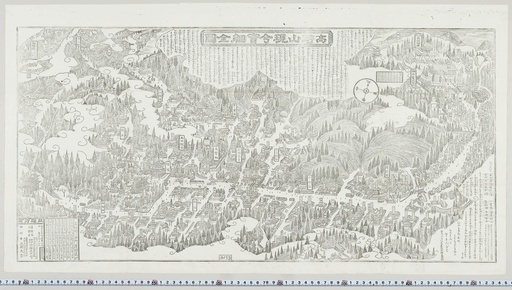
^TOP この場所に行ってみたい このマップを見る 和歌山県 高野町 高野山現今実際全図(こうやさんげんこんじっさいぜんず) 紙本黒色の印刷絵図。明治二十五年(1892)高野山の前岡久五郎により発行。上段中央と下段右方に高野山の略縁起を記す。 江戸時代の高野山の古絵図の系統を受け継ぐが、高野山への道中を縮小して、高野山内を中心的に描く(参考:日野西眞定『高野山古絵図集成解説索引』)。 経路を探す(Google Maps) 体験スポット(高野町) 関西エリアパス ■JTRweb経由での販売■短期滞在の訪日外国人のお客様がご利用いただけるきっぷです。 ■自由周遊区間内の特急「はるか」号、普通列車(新快速・快速を含む)や西日本ジェイアールバスが1~4日間乗り放題です。 ※最大2列車まで特急「はるか」号の普通車指定席がご利用いただけます。■レンタサイクル「駅リンくん」もご利用いただけます。■京阪電鉄、京都市営地下鉄、阪急電鉄の1日乗車券の引換券も付随しています。 ホームページはこちら 関西ワイドエリアパス 訪日外国人向けの5日間有効のきっぷで、山陽新幹線や特急列車、普通列車、地方鉄道、バスが自由に利用できます。最大6本まで普通車指定席が利用可能で、事前予約が必要です。 ホームページはこちら 楽しい和歌山パス ■JTRweb経由での販売■複数の観光施設を1枚のQRコードで周遊できます。観光名所やグルメ、寺など多様な施設をお得に周遊できますので、是非ご利用ください! ホームページはこちら 観光ガイドの出来る乗務員が案内する貸切タクシーチャータープラン 和歌山市内、海南市内の最寄りの駅やホテルから出発! お客様のご希望によっては和歌山県下の観光ガイドも致します。 (事前連絡要) ホームページはこちら --> 関西・北陸エリアパス ●JTRwebでの販売●短期滞在の訪日外国人のお客様がご利用いただける きっぷです。●自由周遊区間内の北陸新幹線、山陽新幹線、特急列車、普通 列車(新快速・快速含む)、あいの風とやま鉄道、IRいしかわ鉄道、ハピライン ふくい、のと鉄道、京都丹後鉄道、和歌山電鐵、西日本ジェイアールバスが7 日間乗り放題です。●普通車指定席が何度でもご利用いただけます。(指定席 をご利用の際は、必ず事前に指定席を予約してからご乗車ください)●レンタサ イクル「駅リンくん」もご利用いただけます(おとなのみ)。 ホームページはこちら 関西・広島エリアパス ●JTRwebでの販売●短期滞在の訪日外国人のお客様がご利用いただけるきっぷです。 ●自由周遊区間内の山陽新幹線、特急列車、普通列車(新快速・快速含む)、京都丹後鉄道、和歌山電鐵、西日本ジェイアールバス、JRバス中国、JR西日本宮島フェリーが5日間乗り放題です。 ●普通車指定席が何度でもご利用いただけます。(指定席をご利用の際は、必ず事前に指定席を予約してからご乗車ください。)●レンタサイクル「駅リンくん」もご利用いただけます(おとなのみ)。 ホームページはこちら 関西・山陰エリアパス ●JTRwebでの販売●短期滞在の訪日外国人のお客様がご利用いただけるきっぷです。 ●自由周遊区間内の山陽新幹線、特急列車、普通列車(新快速・快速含む)、京都丹後鉄道、智頭急行、西日本ジェイアールバスが7日間乗り放題です。 ●普通車指定席が何度でもご利用いただけます。(指定席をご利用の際は、必ず事前に指定席を予約してからご乗車ください。) ●レンタサイクル「駅リンくん」もご利用いただけます(おとなのみ)。 ホームページはこちら 和歌山市内観光(貸切)ジャンボタクシー 和歌山市内を中心に、観光名所(和歌山城天守閣・紅葉渓庭園、紀州東照宮、紀三井寺など)を周遊します。貸切のジャンボタクシーなので、ご家族やご友人などと、お荷物などを気にせず、ゆっくり観光したい場合には、ぜひご利用ください。 ホームページはこちら -->
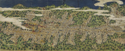
^TOP この場所に行ってみたい このマップを見る 和歌山県 高野町 高野山之図(こうやさんのず) 紙本着色。装丁は畳み物。左方と右方の2舗。江戸時代後期に描かれたものと推定。 建物の側に小型方形の枠を作り、その中に寺院名や建物の名を入れる。その総計は585。 奥之院の入口の一之橋に入った右側には谷の者(たにのもの)と称された三昧聖(さんまいひじり)の43棟の寺院が見られる。 描かれた人物は僧侶・寺侍・参詣人等73人である(参考:石原友希恵「高野山之図-寺院名と描かれた人物-」『高野山大学図書館紀要』第1号所収)。 経路を探す(Google Maps) 体験スポット(高野町) 関西エリアパス ■JTRweb経由での販売■短期滞在の訪日外国人のお客様がご利用いただけるきっぷです。 ■自由周遊区間内の特急「はるか」号、普通列車(新快速・快速を含む)や西日本ジェイアールバスが1~4日間乗り放題です。 ※最大2列車まで特急「はるか」号の普通車指定席がご利用いただけます。■レンタサイクル「駅リンくん」もご利用いただけます。■京阪電鉄、京都市営地下鉄、阪急電鉄の1日乗車券の引換券も付随しています。 ホームページはこちら 関西ワイドエリアパス 訪日外国人向けの5日間有効のきっぷで、山陽新幹線や特急列車、普通列車、地方鉄道、バスが自由に利用できます。最大6本まで普通車指定席が利用可能で、事前予約が必要です。 ホームページはこちら 楽しい和歌山パス ■JTRweb経由での販売■複数の観光施設を1枚のQRコードで周遊できます。観光名所やグルメ、寺など多様な施設をお得に周遊できますので、是非ご利用ください! ホームページはこちら 観光ガイドの出来る乗務員が案内する貸切タクシーチャータープラン 和歌山市内、海南市内の最寄りの駅やホテルから出発! お客様のご希望によっては和歌山県下の観光ガイドも致します。 (事前連絡要) ホームページはこちら --> 関西・北陸エリアパス ●JTRwebでの販売●短期滞在の訪日外国人のお客様がご利用いただける きっぷです。●自由周遊区間内の北陸新幹線、山陽新幹線、特急列車、普通 列車(新快速・快速含む)、あいの風とやま鉄道、IRいしかわ鉄道、ハピライン ふくい、のと鉄道、京都丹後鉄道、和歌山電鐵、西日本ジェイアールバスが7 日間乗り放題です。●普通車指定席が何度でもご利用いただけます。(指定席 をご利用の際は、必ず事前に指定席を予約してからご乗車ください)●レンタサ イクル「駅リンくん」もご利用いただけます(おとなのみ)。 ホームページはこちら 関西・広島エリアパス ●JTRwebでの販売●短期滞在の訪日外国人のお客様がご利用いただけるきっぷです。 ●自由周遊区間内の山陽新幹線、特急列車、普通列車(新快速・快速含む)、京都丹後鉄道、和歌山電鐵、西日本ジェイアールバス、JRバス中国、JR西日本宮島フェリーが5日間乗り放題です。 ●普通車指定席が何度でもご利用いただけます。(指定席をご利用の際は、必ず事前に指定席を予約してからご乗車ください。)●レンタサイクル「駅リンくん」もご利用いただけます(おとなのみ)。 ホームページはこちら 関西・山陰エリアパス ●JTRwebでの販売●短期滞在の訪日外国人のお客様がご利用いただけるきっぷです。 ●自由周遊区間内の山陽新幹線、特急列車、普通列車(新快速・快速含む)、京都丹後鉄道、智頭急行、西日本ジェイアールバスが7日間乗り放題です。 ●普通車指定席が何度でもご利用いただけます。(指定席をご利用の際は、必ず事前に指定席を予約してからご乗車ください。) ●レンタサイクル「駅リンくん」もご利用いただけます(おとなのみ)。 ホームページはこちら 和歌山市内観光(貸切)ジャンボタクシー 和歌山市内を中心に、観光名所(和歌山城天守閣・紅葉渓庭園、紀州東照宮、紀三井寺など)を周遊します。貸切のジャンボタクシーなので、ご家族やご友人などと、お荷物などを気にせず、ゆっくり観光したい場合には、ぜひご利用ください。 ホームページはこちら -->
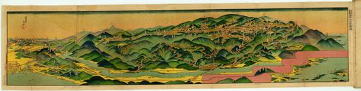
^TOP この場所に行ってみたい このマップを見る 和歌山県 高野町 高野山, 和歌山県:吉田初三郎 (1922) 備考・折りたたみ28cm・大正11年1月10日印刷 大正11年1月15日發行・資料課の袋には「1921」とあり・裏に高野山案内あり ランドマークに追加した絵葉書はサンプルとして高野山アーカイブ https://archives.koyasan-u.ac.jp/) --> を利用させていただきました。 経路を探す(Google Maps) 体験スポット(高野町) 関西エリアパス ■JTRweb経由での販売■短期滞在の訪日外国人のお客様がご利用いただけるきっぷです。 ■自由周遊区間内の特急「はるか」号、普通列車(新快速・快速を含む)や西日本ジェイアールバスが1~4日間乗り放題です。 ※最大2列車まで特急「はるか」号の普通車指定席がご利用いただけます。■レンタサイクル「駅リンくん」もご利用いただけます。■京阪電鉄、京都市営地下鉄、阪急電鉄の1日乗車券の引換券も付随しています。 ホームページはこちら 関西ワイドエリアパス 訪日外国人向けの5日間有効のきっぷで、山陽新幹線や特急列車、普通列車、地方鉄道、バスが自由に利用できます。最大6本まで普通車指定席が利用可能で、事前予約が必要です。 ホームページはこちら 楽しい和歌山パス ■JTRweb経由での販売■複数の観光施設を1枚のQRコードで周遊できます。観光名所やグルメ、寺など多様な施設をお得に周遊できますので、是非ご利用ください! ホームページはこちら 観光ガイドの出来る乗務員が案内する貸切タクシーチャータープラン 和歌山市内、海南市内の最寄りの駅やホテルから出発! お客様のご希望によっては和歌山県下の観光ガイドも致します。 (事前連絡要) ホームページはこちら --> 関西・北陸エリアパス ●JTRwebでの販売●短期滞在の訪日外国人のお客様がご利用いただける きっぷです。●自由周遊区間内の北陸新幹線、山陽新幹線、特急列車、普通 列車(新快速・快速含む)、あいの風とやま鉄道、IRいしかわ鉄道、ハピライン ふくい、のと鉄道、京都丹後鉄道、和歌山電鐵、西日本ジェイアールバスが7 日間乗り放題です。●普通車指定席が何度でもご利用いただけます。(指定席 をご利用の際は、必ず事前に指定席を予約してからご乗車ください)●レンタサ イクル「駅リンくん」もご利用いただけます(おとなのみ)。 ホームページはこちら 関西・広島エリアパス ●JTRwebでの販売●短期滞在の訪日外国人のお客様がご利用いただけるきっぷです。 ●自由周遊区間内の山陽新幹線、特急列車、普通列車(新快速・快速含む)、京都丹後鉄道、和歌山電鐵、西日本ジェイアールバス、JRバス中国、JR西日本宮島フェリーが5日間乗り放題です。 ●普通車指定席が何度でもご利用いただけます。(指定席をご利用の際は、必ず事前に指定席を予約してからご乗車ください。)●レンタサイクル「駅リンくん」もご利用いただけます(おとなのみ)。 ホームページはこちら 関西・山陰エリアパス ●JTRwebでの販売●短期滞在の訪日外国人のお客様がご利用いただけるきっぷです。 ●自由周遊区間内の山陽新幹線、特急列車、普通列車(新快速・快速含む)、京都丹後鉄道、智頭急行、西日本ジェイアールバスが7日間乗り放題です。 ●普通車指定席が何度でもご利用いただけます。(指定席をご利用の際は、必ず事前に指定席を予約してからご乗車ください。) ●レンタサイクル「駅リンくん」もご利用いただけます(おとなのみ)。 ホームページはこちら 和歌山市内観光(貸切)ジャンボタクシー 和歌山市内を中心に、観光名所(和歌山城天守閣・紅葉渓庭園、紀州東照宮、紀三井寺など)を周遊します。貸切のジャンボタクシーなので、ご家族やご友人などと、お荷物などを気にせず、ゆっくり観光したい場合には、ぜひご利用ください。 ホームページはこちら -->
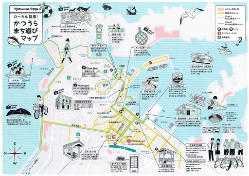
^TOP この場所に行ってみたい このマップを見る 那智勝浦町, 和歌山県 かつうらまち遊びマップ 和歌山県那智勝浦町の観光スポットを紹介しています。 那智の滝や熊野古道などの名所、温泉地、港町の魅力が描かれており、歴史や自然を楽しめるエリアを網羅しています。 経路を探す(Google Maps) 体験スポット(那智勝浦町) 悠遊フリー乗車券(1日券、2日券、3日券)/那智エリア世界遺産フリー乗車券 悠遊フリー乗車券:世界遺産熊野三山や熊野古道の散策に、格安で便利な「フリー乗車券」を販売しております。ぜひこの機会に、世界遺産の旅をご満喫下さい。/ 那智エリア世界遺産フリー乗車券:紀伊勝浦駅から乗車いただいて、那智駅~那智山間で乗り降り自由の乗車券です。 ホームページはこちら 関西エリアパス ■JTRweb経由での販売■短期滞在の訪日外国人のお客様がご利用いただけるきっぷです。 ■自由周遊区間内の特急「はるか」号、普通列車(新快速・快速を含む)や西日本ジェイアールバスが1~4日間乗り放題です。 ※最大2列車まで特急「はるか」号の普通車指定席がご利用いただけます。■レンタサイクル「駅リンくん」もご利用いただけます。■京阪電鉄、京都市営地下鉄、阪急電鉄の1日乗車券の引換券も付随しています。 ホームページはこちら 関西ワイドエリアパス 訪日外国人向けの5日間有効のきっぷで、山陽新幹線や特急列車、普通列車、地方鉄道、バスが自由に利用できます。最大6本まで普通車指定席が利用可能で、事前予約が必要です。 ホームページはこちら --> 串本海中公園 水族館・海中展望台/JR西日本連携商品 ■JTRweb経由での販売■串本の海は、黒潮の影響を強く受け、色とりどりの熱帯魚や、世界の北限と言われるテーブルサンゴの群落など、美しい海中景観を一年中楽しむことができます。串本の海を再現した水族館や海中展望塔が設けられています。 ホームページはこちら 太地町立くじらの博物館 捕鯨の歴史や文化、生態学的資料を展示する博物館と生体を展示する水族館の要素を併せ持つ施設です。クジラショーやイルカショーや体験イベントも充実しているので、五感でクジラについて学ぶことができます。 ホームページはこちら 楽しい和歌山パス ■JTRweb経由での販売■複数の観光施設を1枚のQRコードで周遊できます。観光名所やグルメ、寺など多様な施設をお得に周遊できますので、是非ご利用ください! ホームページはこちら ヘリコプターチャーター 加賀エアロシステム株式会社は、南紀白浜空港に拠点を置く、ヘリコプターの運航会社です。 ヘリコプター遊覧、移動の足としての利用、ビジネスでの利用等、お客様の目的にあわせた運航をご提供いたします。 ホームページはこちら 街中チョイのりサイクル 電動アシスト自転車で楽々町内観光スポットを回れます。3時間コース、1日コース他あり。 ホームページはこちら 北山川観光筏下り 日本で唯一、伝統的な丸太筏を造る技術と操る技を今に残し受け継いでいる北山川観光筏下り。 北山川の大峡谷の中、迫る急流を肌で体感しながら、約600年の筏師の歴史に触れる。 飛び地の村北山村でしか体験できない北山川観光筏下りで夏を楽しもう! ホームページはこちら 瀞峡めぐり川舟クルーズ 和歌山県、三重県、奈良県にまたがる瀞峡と呼ばれる渓谷を、往復40分で遊覧する川舟クルーズです。瀞峡は、1928年に国名勝・天然記念物、1952年には国特別名勝にしてされた国内でも歴史のある観光地のひとつです。一隻の定員が5.6名ほどの小さな川舟に乗り、船頭が各所を説明しながら、遊覧します。透き通る川や荘厳な山々など、瀞峡が持つ大自然の営みを全身で感じられる川舟体験は、唯一無二の癒しの時間です。 ホームページはこちら 世界遺産&日本遺産を体感 ガイドと歩く・熊野古道高野坂 熊野古道中辺路ルートで唯一海の見える古道。アップダウンも少ない初心者コースです。 ホームページはこちら 新宮世界遺産3社巡りガイドウォーク 新宮市内にある世界文化遺産の【熊野速玉大社】【神倉神社】【阿須賀神社】三社をガイドの案内で散策します。 ホームページはこちら 紀の松島めぐり 紀の松島は周囲17kmの区間に大自然が創造した和歌山随一の海岸美です。紺碧の海に浮かぶ絶景を是非お楽しみ下さい。 ホームページはこちら 関西・北陸エリアパス ●JTRwebでの販売●短期滞在の訪日外国人のお客様がご利用いただける きっぷです。●自由周遊区間内の北陸新幹線、山陽新幹線、特急列車、普通 列車(新快速・快速含む)、あいの風とやま鉄道、IRいしかわ鉄道、ハピライン ふくい、のと鉄道、京都丹後鉄道、和歌山電鐵、西日本ジェイアールバスが7 日間乗り放題です。●普通車指定席が何度でもご利用いただけます。(指定席 をご利用の際は、必ず事前に指定席を予約してからご乗車ください)●レンタサ イクル「駅リンくん」もご利用いただけます(おとなのみ)。 ホームページはこちら 関西・広島エリアパス ●JTRwebでの販売●短期滞在の訪日外国人のお客様がご利用いただけるきっぷです。 ●自由周遊区間内の山陽新幹線、特急列車、普通列車(新快速・快速含む)、京都丹後鉄道、和歌山電鐵、西日本ジェイアールバス、JRバス中国、JR西日本宮島フェリーが5日間乗り放題です。 ●普通車指定席が何度でもご利用いただけます。(指定席をご利用の際は、必ず事前に指定席を予約してからご乗車ください。)●レンタサイクル「駅リンくん」もご利用いただけます(おとなのみ)。 ホームページはこちら --> 聖地那智山での非日常的な平安衣装体験 当時の姿を再現した平安衣装に身を包み、古の雰囲気を感じながら神聖な「那智山」を散策。 ホームページはこちら --> --> 熊野三山巡り 古の頃から、ここ聖地「熊野」を救いの地、癒しの地として沢山の人々が苦難を乗り越え、たどり着いた場所。「よみがえりの聖地」熊野三山を巡る旅。 ホームページはこちら -->
橋本・伊都広域観光協議会
![]() 和歌山県
和歌山県

^TOP この場所に行ってみたい このマップを見る 和歌山県 高野・山麓デジタルマップ 和歌山県の高野山と山麓地域の観光施設、飲食店、宿泊施設などを紹介するデジタルマップです。この地域は1市3町で構成されており、4市町すべてが世界遺産を有するという県内でも稀有な地域です。世界遺産の構成資産である数多くの建造物がある高野町、パイル織物やへら竿づくりなどの伝統産業が盛んな橋本市、真田幸村ゆかりの九度山町、そしてフルーツ王国のかつらぎ町と魅力がたくさん!デジタルマップを活用して、ぜひ高野・山麓地域をお楽しみください! 経路を探す(Google Maps) 体験スポット(高野町) 関西エリアパス ■JTRweb経由での販売■短期滞在の訪日外国人のお客様がご利用いただけるきっぷです。 ■自由周遊区間内の特急「はるか」号、普通列車(新快速・快速を含む)や西日本ジェイアールバスが1~4日間乗り放題です。 ※最大2列車まで特急「はるか」号の普通車指定席がご利用いただけます。■レンタサイクル「駅リンくん」もご利用いただけます。■京阪電鉄、京都市営地下鉄、阪急電鉄の1日乗車券の引換券も付随しています。 ホームページはこちら 関西ワイドエリアパス 訪日外国人向けの5日間有効のきっぷで、山陽新幹線や特急列車、普通列車、地方鉄道、バスが自由に利用できます。最大6本まで普通車指定席が利用可能で、事前予約が必要です。 ホームページはこちら 楽しい和歌山パス ■JTRweb経由での販売■複数の観光施設を1枚のQRコードで周遊できます。観光名所やグルメ、寺など多様な施設をお得に周遊できますので、是非ご利用ください! ホームページはこちら 観光ガイドの出来る乗務員が案内する貸切タクシーチャータープラン 和歌山市内、海南市内の最寄りの駅やホテルから出発! お客様のご希望によっては和歌山県下の観光ガイドも致します。 (事前連絡要) ホームページはこちら --> 関西・北陸エリアパス ●JTRwebでの販売●短期滞在の訪日外国人のお客様がご利用いただける きっぷです。●自由周遊区間内の北陸新幹線、山陽新幹線、特急列車、普通 列車(新快速・快速含む)、あいの風とやま鉄道、IRいしかわ鉄道、ハピライン ふくい、のと鉄道、京都丹後鉄道、和歌山電鐵、西日本ジェイアールバスが7 日間乗り放題です。●普通車指定席が何度でもご利用いただけます。(指定席 をご利用の際は、必ず事前に指定席を予約してからご乗車ください)●レンタサ イクル「駅リンくん」もご利用いただけます(おとなのみ)。 ホームページはこちら 関西・広島エリアパス ●JTRwebでの販売●短期滞在の訪日外国人のお客様がご利用いただけるきっぷです。 ●自由周遊区間内の山陽新幹線、特急列車、普通列車(新快速・快速含む)、京都丹後鉄道、和歌山電鐵、西日本ジェイアールバス、JRバス中国、JR西日本宮島フェリーが5日間乗り放題です。 ●普通車指定席が何度でもご利用いただけます。(指定席をご利用の際は、必ず事前に指定席を予約してからご乗車ください。)●レンタサイクル「駅リンくん」もご利用いただけます(おとなのみ)。 ホームページはこちら 関西・山陰エリアパス ●JTRwebでの販売●短期滞在の訪日外国人のお客様がご利用いただけるきっぷです。 ●自由周遊区間内の山陽新幹線、特急列車、普通列車(新快速・快速含む)、京都丹後鉄道、智頭急行、西日本ジェイアールバスが7日間乗り放題です。 ●普通車指定席が何度でもご利用いただけます。(指定席をご利用の際は、必ず事前に指定席を予約してからご乗車ください。) ●レンタサイクル「駅リンくん」もご利用いただけます(おとなのみ)。 ホームページはこちら 和歌山市内観光(貸切)ジャンボタクシー 和歌山市内を中心に、観光名所(和歌山城天守閣・紅葉渓庭園、紀州東照宮、紀三井寺など)を周遊します。貸切のジャンボタクシーなので、ご家族やご友人などと、お荷物などを気にせず、ゆっくり観光したい場合には、ぜひご利用ください。 ホームページはこちら -->
 三重県
三重県

^TOP この場所に行ってみたい このマップを見る 三重県 伊勢市 おかげ横丁デジタル絵地図 おかげ横丁のデジタル絵地図を公開しています。マップ上では、おかげ横丁の店舗に関する情報が表示されるほか、GPSを使った現在地情報の表示、マップの切替などができ、バーチャルな観光体験が可能です。 経路を探す(Google Maps) 体験スポット(伊勢市) 近鉄レールパス 近鉄レールパスは、1日乗り放題の1day、2日間有効の2day、5day、5day plusの4つのパスで、大阪、京都、奈良、名古屋、三重(伊勢志摩)エリアで利用できます。各パスには観光施設での優待・特典が付いています。 ホームページはこちら 伊勢の地で採れたはちみつを使用したリップクリーム&ハンドクリーム手作り体験 伊勢の地を含め日本で採れた「はちみつ」の中からテイスティングして気に入った「はちみつ」を使って、オリジナルのリップクリームとハンドクリームの手作り体験が楽しめます。 ホームページはこちら 観光タクシー(伊勢志摩周遊) 熟練したドライバーがご案内する観光タクシーで、伊勢神宮や二見夫婦岩、御木本真珠等など 伊勢志摩の観光スポットをご希望に合わせて効率的に周遊していただけます。 ホームページはこちら 関西・北陸エリアパス ●JTRwebでの販売●短期滞在の訪日外国人のお客様がご利用いただける きっぷです。●自由周遊区間内の北陸新幹線、山陽新幹線、特急列車、普通 列車(新快速・快速含む)、あいの風とやま鉄道、IRいしかわ鉄道、ハピライン ふくい、のと鉄道、京都丹後鉄道、和歌山電鐵、西日本ジェイアールバスが7 日間乗り放題です。●普通車指定席が何度でもご利用いただけます。(指定席 をご利用の際は、必ず事前に指定席を予約してからご乗車ください)●レンタサ イクル「駅リンくん」もご利用いただけます(おとなのみ)。 ホームページはこちら 関西・広島エリアパス ●JTRwebでの販売●短期滞在の訪日外国人のお客様がご利用いただけるきっぷです。 ●自由周遊区間内の山陽新幹線、特急列車、普通列車(新快速・快速含む)、京都丹後鉄道、和歌山電鐵、西日本ジェイアールバス、JRバス中国、JR西日本宮島フェリーが5日間乗り放題です。 ●普通車指定席が何度でもご利用いただけます。(指定席をご利用の際は、必ず事前に指定席を予約してからご乗車ください。)●レンタサイクル「駅リンくん」もご利用いただけます(おとなのみ)。 ホームページはこちら 関西・山陰エリアパス ●JTRwebでの販売●短期滞在の訪日外国人のお客様がご利用いただけるきっぷです。 ●自由周遊区間内の山陽新幹線、特急列車、普通列車(新快速・快速含む)、京都丹後鉄道、智頭急行、西日本ジェイアールバスが7日間乗り放題です。 ●普通車指定席が何度でもご利用いただけます。(指定席をご利用の際は、必ず事前に指定席を予約してからご乗車ください。) ●レンタサイクル「駅リンくん」もご利用いただけます(おとなのみ)。 ホームページはこちら
^TOP この場所に行ってみたい このマップを見る 三重県 伊賀市 伊賀上野城下町まち歩きマップ 伊賀市は伊賀流忍者発祥の地!大阪・京都から電車・車どちらでも約90分でお越しいただけます。 この観光デジタルマップ上では、伊賀上野城、伊賀流忍者博物館を中心とした城下町エリアの観光スポット、お土産などおススメの伊賀の観光情報をご紹介します。 経路を探す(Google Maps) 体験スポット(伊賀市) 近鉄レールパス 近鉄レールパスは、1日乗り放題の1day、2日間有効の2day、5day、5day plusの4つのパスで、大阪、京都、奈良、名古屋、三重(伊勢志摩)エリアで利用できます。各パスには観光施設での優待・特典が付いています。 ホームページはこちら 1日1組限定!伊賀流忍者屋敷プライベートツアー なぜ伊賀は忍者の里となったのか?屋敷に施されたからくりのヒミツとは?忍者の真実の姿を閉館後の忍者屋敷を利用した1日1組限定でのプライベートツアー。案内だけではなく普段では触れることが出来ない忍具や貴重な古文書を特別閲覧や忍者からレクチャーを受けてからくりを体験することができます。 ホームページはこちら --> 糸と交わりの美 日本の伝統工芸・伊賀くみひも 普段は非公開である匠の工房に入り、伊賀くみひもの職人技を間近で見学しながら、伝統のくみひも制作を学びます。自らも実際に組みひもづくりを体験し、オリジナルキーホルダーとして持ち帰ります。 ホームページはこちら --> レンタカー オリックスレンタカーのフランチャイジーとして、近鉄沿線を中心に大阪地区4店舗、奈良地区5店舗、三重地区9店舗でレンタカー店舗を運営しています。少人数・家族旅行向けの軽自動車・コンパクトカーからグループ旅行に最適なワゴン車まで、様々なお車をご用意しております。近鉄沿線のレンタカーのご用命はすべての店舗が駅前&駅近の近鉄レンタリースへ! ホームページはこちら かつての山城で本格的忍者体験 忍術が修練されたかつての山城を使って、日本忍者協議会公認の師範忍者が忍術体験を指導します。道場内で基本的な動きを学び、民泊施設内で地産の無農薬有機米・野菜・井戸水を使った昼食を楽しみ、その後山城で本格的忍術体験を行います。 ホームページはこちら 関西・北陸エリアパス ●JTRwebでの販売●短期滞在の訪日外国人のお客様がご利用いただける きっぷです。●自由周遊区間内の北陸新幹線、山陽新幹線、特急列車、普通 列車(新快速・快速含む)、あいの風とやま鉄道、IRいしかわ鉄道、ハピライン ふくい、のと鉄道、京都丹後鉄道、和歌山電鐵、西日本ジェイアールバスが7 日間乗り放題です。●普通車指定席が何度でもご利用いただけます。(指定席 をご利用の際は、必ず事前に指定席を予約してからご乗車ください)●レンタサ イクル「駅リンくん」もご利用いただけます(おとなのみ)。 ホームページはこちら 関西・広島エリアパス ●JTRwebでの販売●短期滞在の訪日外国人のお客様がご利用いただけるきっぷです。 ●自由周遊区間内の山陽新幹線、特急列車、普通列車(新快速・快速含む)、京都丹後鉄道、和歌山電鐵、西日本ジェイアールバス、JRバス中国、JR西日本宮島フェリーが5日間乗り放題です。 ●普通車指定席が何度でもご利用いただけます。(指定席をご利用の際は、必ず事前に指定席を予約してからご乗車ください。)●レンタサイクル「駅リンくん」もご利用いただけます(おとなのみ)。 ホームページはこちら 関西・山陰エリアパス ●JTRwebでの販売●短期滞在の訪日外国人のお客様がご利用いただけるきっぷです。 ●自由周遊区間内の山陽新幹線、特急列車、普通列車(新快速・快速含む)、京都丹後鉄道、智頭急行、西日本ジェイアールバスが7日間乗り放題です。 ●普通車指定席が何度でもご利用いただけます。(指定席をご利用の際は、必ず事前に指定席を予約してからご乗車ください。) ●レンタサイクル「駅リンくん」もご利用いただけます(おとなのみ)。 ホームページはこちら

この場所に行ってみたい このマップを見る 三重県 尾鷲市 尾鷲市マップ 三重県南部、尾鷲のまち。目の前には黒潮流れる熊野灘が広がり、背後には日本有数の降雨量を誇る大台山系がそびえます。前浜に毎日水揚げされる魚をはじめ、美味しいものがたくさん。美味しいお店もたくさんあります。海や山、世界遺産の熊野古道を訪ねながらお店めぐりをお楽しみください。 経路を探す(Google Maps) 体験スポット(尾鷲市) 近鉄レールパス 近鉄レールパスは、1日乗り放題の1day、2日間有効の2day、5day、5day plusの4つのパスで、大阪、京都、奈良、名古屋、三重(伊勢志摩)エリアで利用できます。各パスには観光施設での優待・特典が付いています。 ホームページはこちら 伊勢志摩絶景ドライブ 標高555mの朝熊山を縦走し、伊勢と鳥羽を結ぶ全長約16kmの天空ドライブウェイ。 ホームページはこちら おわせプライベート岩ヨガ体験 岩の上でヨガをする貴女だけの時間と空間が、「尾鷲(おわせ)」にはあります。 ホームページはこちら 絶景・天狗倉山と岩屋堂トレッキング~古(いにしえ)の山岳信仰・修験道の足跡を辿る 祈りの道「世界遺産熊野古道馬越峠」を歩き、修験道ゆかりの祈りの場を巡ります。 ホームページはこちら 関西・北陸エリアパス ●JTRwebでの販売●短期滞在の訪日外国人のお客様がご利用いただける きっぷです。●自由周遊区間内の北陸新幹線、山陽新幹線、特急列車、普通 列車(新快速・快速含む)、あいの風とやま鉄道、IRいしかわ鉄道、ハピライン ふくい、のと鉄道、京都丹後鉄道、和歌山電鐵、西日本ジェイアールバスが7 日間乗り放題です。●普通車指定席が何度でもご利用いただけます。(指定席 をご利用の際は、必ず事前に指定席を予約してからご乗車ください)●レンタサ イクル「駅リンくん」もご利用いただけます(おとなのみ)。 ホームページはこちら 関西・広島エリアパス ●JTRwebでの販売●短期滞在の訪日外国人のお客様がご利用いただけるきっぷです。 ●自由周遊区間内の山陽新幹線、特急列車、普通列車(新快速・快速含む)、京都丹後鉄道、和歌山電鐵、西日本ジェイアールバス、JRバス中国、JR西日本宮島フェリーが5日間乗り放題です。 ●普通車指定席が何度でもご利用いただけます。(指定席をご利用の際は、必ず事前に指定席を予約してからご乗車ください。)●レンタサイクル「駅リンくん」もご利用いただけます(おとなのみ)。 ホームページはこちら 関西・山陰エリアパス ●JTRwebでの販売●短期滞在の訪日外国人のお客様がご利用いただけるきっぷです。 ●自由周遊区間内の山陽新幹線、特急列車、普通列車(新快速・快速含む)、京都丹後鉄道、智頭急行、西日本ジェイアールバスが7日間乗り放題です。 ●普通車指定席が何度でもご利用いただけます。(指定席をご利用の際は、必ず事前に指定席を予約してからご乗車ください。) ●レンタサイクル「駅リンくん」もご利用いただけます(おとなのみ)。 ホームページはこちら

^TOP この場所に行ってみたい このマップを見る 三重県 朝熊ヶ岳参詣マップ~朝熊岳 道をいく~ 古くから修験道の霊場として知られる朝熊ヶ岳の登山コースを紹介し、美しい自然に囲まれた山岳地帯を歩きながら、歴史的な神社や仏閣を訪れることができます。清流や滝、四季折々の風景が広がる中で、山岳信仰の精神を体験しながら心身をリフレッシュできる空間となっています。 経路を探す(Google Maps) 体験スポット(朝熊ヶ岳市) 近鉄レールパス 近鉄レールパスは、1日乗り放題の1day、2日間有効の2day、5day、5day plusの4つのパスで、大阪、京都、奈良、名古屋、三重(伊勢志摩)エリアで利用できます。各パスには観光施設での優待・特典が付いています。 ホームページはこちら 伊勢志摩絶景ドライブ 標高555mの朝熊山を縦走し、伊勢と鳥羽を結ぶ全長約16kmの天空ドライブウェイ。 ホームページはこちら レンタカー オリックスレンタカーのフランチャイジーとして、近鉄沿線を中心に大阪地区4店舗、奈良地区5店舗、三重地区9店舗でレンタカー店舗を運営しています。少人数・家族旅行向けの軽自動車・コンパクトカーからグループ旅行に最適なワゴン車まで、様々なお車をご用意しております。近鉄沿線のレンタカーのご用命はすべての店舗が駅前&駅近の近鉄レンタリースへ! ホームページはこちら 関西・北陸エリアパス ●JTRwebでの販売●短期滞在の訪日外国人のお客様がご利用いただける きっぷです。●自由周遊区間内の北陸新幹線、山陽新幹線、特急列車、普通 列車(新快速・快速含む)、あいの風とやま鉄道、IRいしかわ鉄道、ハピライン ふくい、のと鉄道、京都丹後鉄道、和歌山電鐵、西日本ジェイアールバスが7 日間乗り放題です。●普通車指定席が何度でもご利用いただけます。(指定席 をご利用の際は、必ず事前に指定席を予約してからご乗車ください)●レンタサ イクル「駅リンくん」もご利用いただけます(おとなのみ)。 ホームページはこちら 関西・広島エリアパス ●JTRwebでの販売●短期滞在の訪日外国人のお客様がご利用いただけるきっぷです。 ●自由周遊区間内の山陽新幹線、特急列車、普通列車(新快速・快速含む)、京都丹後鉄道、和歌山電鐵、西日本ジェイアールバス、JRバス中国、JR西日本宮島フェリーが5日間乗り放題です。 ●普通車指定席が何度でもご利用いただけます。(指定席をご利用の際は、必ず事前に指定席を予約してからご乗車ください。)●レンタサイクル「駅リンくん」もご利用いただけます(おとなのみ)。 ホームページはこちら 関西・山陰エリアパス ●JTRwebでの販売●短期滞在の訪日外国人のお客様がご利用いただけるきっぷです。 ●自由周遊区間内の山陽新幹線、特急列車、普通列車(新快速・快速含む)、京都丹後鉄道、智頭急行、西日本ジェイアールバスが7日間乗り放題です。 ●普通車指定席が何度でもご利用いただけます。(指定席をご利用の際は、必ず事前に指定席を予約してからご乗車ください。) ●レンタサイクル「駅リンくん」もご利用いただけます(おとなのみ)。 ホームページはこちら
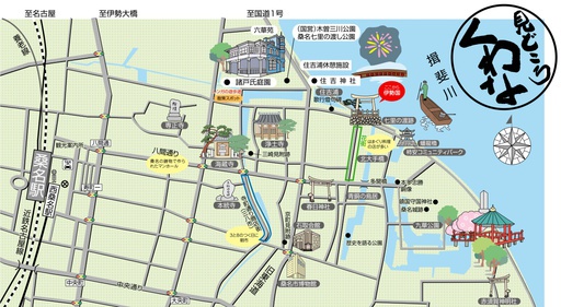
^TOP この場所に行ってみたい このマップを見る 三重県 桑名市 「見どころくわな」オンラインマップ 桑名駅の東側を中心に、桑名の「見どころ」を紹介するマップです。おすすめの観光スポット、グルメなどを掲載していますので、桑名を訪れた方も、お住まいの方も、ぜひこのマップをご活用いただき、桑名の魅力に触れてみてください!2025年度末までを目途に公表しています。 経路を探す(Google Maps) 体験スポット(桑名市) 近鉄レールパス 近鉄レールパスは、1日乗り放題の1day、2日間有効の2day、5day、5day plusの4つのパスで、大阪、京都、奈良、名古屋、三重(伊勢志摩)エリアで利用できます。各パスには観光施設での優待・特典が付いています。 ホームページはこちら 丸ごと三重!産業観光ツアー 「三重県産業観光推進協議会」は地域産業と企業を結びつけた観光コースを提供する団体です。エイベックス(株)は工場視察ツアーを提供しており多くの国から4千人以上の参加実績があり、カスタマイズされたツアーを提供しています。 ホームページはこちら --> 日本の学校見学ツアー「給食体験・清掃体験」をしよう 学校法人津田学園は、スポーツや芸術・文化振興を目的とする各種教室を開く総合学園として発展しています。その学園内で自立した日本文化を学ぶコンテンツとして給食体験・清掃体験ができます。 ホームページはこちら --> 日本製造業見学ツアー「長寿企業経営者と交流会」をしよう 企業経営のゴールは収益を最大化させることではなく、事業を次の世代、次の次の世代に継承して永続を図ることにある。長寿経営を実現している経営者と交流し経営に関する取り組みを見直してみる機会にしませんか。 ホームページはこちら --> 関西・北陸エリアパス ●JTRwebでの販売●短期滞在の訪日外国人のお客様がご利用いただける きっぷです。●自由周遊区間内の北陸新幹線、山陽新幹線、特急列車、普通 列車(新快速・快速含む)、あいの風とやま鉄道、IRいしかわ鉄道、ハピライン ふくい、のと鉄道、京都丹後鉄道、和歌山電鐵、西日本ジェイアールバスが7 日間乗り放題です。●普通車指定席が何度でもご利用いただけます。(指定席 をご利用の際は、必ず事前に指定席を予約してからご乗車ください)●レンタサ イクル「駅リンくん」もご利用いただけます(おとなのみ)。 ホームページはこちら 関西・広島エリアパス ●JTRwebでの販売●短期滞在の訪日外国人のお客様がご利用いただけるきっぷです。 ●自由周遊区間内の山陽新幹線、特急列車、普通列車(新快速・快速含む)、京都丹後鉄道、和歌山電鐵、西日本ジェイアールバス、JRバス中国、JR西日本宮島フェリーが5日間乗り放題です。 ●普通車指定席が何度でもご利用いただけます。(指定席をご利用の際は、必ず事前に指定席を予約してからご乗車ください。)●レンタサイクル「駅リンくん」もご利用いただけます(おとなのみ)。 ホームページはこちら 関西・山陰エリアパス ●JTRwebでの販売●短期滞在の訪日外国人のお客様がご利用いただけるきっぷです。 ●自由周遊区間内の山陽新幹線、特急列車、普通列車(新快速・快速含む)、京都丹後鉄道、智頭急行、西日本ジェイアールバスが7日間乗り放題です。 ●普通車指定席が何度でもご利用いただけます。(指定席をご利用の際は、必ず事前に指定席を予約してからご乗車ください。) ●レンタサイクル「駅リンくん」もご利用いただけます(おとなのみ)。 ホームページはこちら
 福井県
福井県
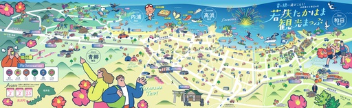
^TOP この場所に行ってみたい このマップを見る 福井県 高浜町 青と緑に飛び込もう!自然豊かな海辺の町 若狭たかはま観光マップ 数えで7年に一度開催される福井県高浜町の伝統行事「高浜七年祭(たかはましちねんまつり)」が、2025年6月15日(日)から6月21日(土)までの7日間にわたり開催されます。町内各地で神輿渡御や奉納芸能、伝統儀式など多彩な催しが行われ、地域の歴史と文化を肌で感じる貴重な機会となっています。7年に一度の特別な祭りを、ぜひ現地で体験してください。 経路を探す(Google Maps) 体験スポット(福井県 高浜町周辺) 蘇洞門めぐり 蘇洞門は若狭湾国定公園内の美しい景勝地で断崖美や奇岩、洞門、洞窟が見どころで、国の名勝に指定されています。ビューポイントには「大門・小門」、「唐船島」、「夫婦亀岩」、「白糸の滝」などがあります。 ホームページはこちら 関西エリアパス ■JTRweb経由での販売■短期滞在の訪日外国人のお客様がご利用いただけるきっぷです。 ■自由周遊区間内の特急「はるか」号、普通列車(新快速・快速を含む)や西日本ジェイアールバスが1~4日間乗り放題です。 ※最大2列車まで特急「はるか」号の普通車指定席がご利用いただけます。■レンタサイクル「駅リンくん」もご利用いただけます。■京阪電鉄、京都市営地下鉄、阪急電鉄の1日乗車券の引換券も付随しています。 ホームページはこちら 関西ワイドエリアパス 訪日外国人向けの5日間有効のきっぷで、山陽新幹線や特急列車、普通列車、地方鉄道、バスが自由に利用できます。最大6本まで普通車指定席が利用可能で、事前予約が必要です。 ホームページはこちら 楽しい福井パス ■JTRweb経由での販売■複数の観光施設を1枚のQRコードで周遊できます。北陸新幹線が延伸する福井県内の観光名所やグルメ、お城など多様な施設をお得に周遊できますので、是非ご利用ください! ホームページはこちら 関西・北陸エリアパス ●JTRwebでの販売●短期滞在の訪日外国人のお客様がご利用いただける きっぷです。●自由周遊区間内の北陸新幹線、山陽新幹線、特急列車、普通 列車(新快速・快速含む)、あいの風とやま鉄道、IRいしかわ鉄道、ハピライン ふくい、のと鉄道、京都丹後鉄道、和歌山電鐵、西日本ジェイアールバスが7 日間乗り放題です。●普通車指定席が何度でもご利用いただけます。(指定席 をご利用の際は、必ず事前に指定席を予約してからご乗車ください)●レンタサ イクル「駅リンくん」もご利用いただけます(おとなのみ)。 ホームページはこちら 関西・広島エリアパス ●JTRwebでの販売●短期滞在の訪日外国人のお客様がご利用いただけるきっぷです。 ●自由周遊区間内の山陽新幹線、特急列車、普通列車(新快速・快速含む)、京都丹後鉄道、和歌山電鐵、西日本ジェイアールバス、JRバス中国、JR西日本宮島フェリーが5日間乗り放題です。 ●普通車指定席が何度でもご利用いただけます。(指定席をご利用の際は、必ず事前に指定席を予約してからご乗車ください。)●レンタサイクル「駅リンくん」もご利用いただけます(おとなのみ)。 ホームページはこちら 関西・山陰エリアパス ●JTRwebでの販売●短期滞在の訪日外国人のお客様がご利用いただけるきっぷです。 ●自由周遊区間内の山陽新幹線、特急列車、普通列車(新快速・快速含む)、京都丹後鉄道、智頭急行、西日本ジェイアールバスが7日間乗り放題です。 ●普通車指定席が何度でもご利用いただけます。(指定席をご利用の際は、必ず事前に指定席を予約してからご乗車ください。) ●レンタサイクル「駅リンくん」もご利用いただけます(おとなのみ)。 ホームページはこちら
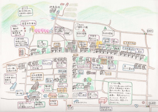
^TOP この場所に行ってみたい このマップを見る 福井県 あわら市 蓮如さんの里吉崎を歩く 吉崎には、通称「御山」と呼ばれる千歳山があります。ここは、1471年(文明3年)に浄土親友中興の祖・蓮如が、布教活動の拠点を置き、多くの門徒が訪れ「吉崎御坊」と呼ばれるようになりました。この御山を中心にあわら市吉崎地区にはいろいろな史跡があり、四季折々の心安らぐ雰囲気を漂させている魅力ある場所となっています。 経路を探す(Google Maps) 体験スポット(あわら市) 関西エリアパス ■JTRweb経由での販売■短期滞在の訪日外国人のお客様がご利用いただけるきっぷです。 ■自由周遊区間内の特急「はるか」号、普通列車(新快速・快速を含む)や西日本ジェイアールバスが1~4日間乗り放題です。 ※最大2列車まで特急「はるか」号の普通車指定席がご利用いただけます。■レンタサイクル「駅リンくん」もご利用いただけます。■京阪電鉄、京都市営地下鉄、阪急電鉄の1日乗車券の引換券も付随しています。 ホームページはこちら 関西ワイドエリアパス 訪日外国人向けの5日間有効のきっぷで、山陽新幹線や特急列車、普通列車、地方鉄道、バスが自由に利用できます。最大6本まで普通車指定席が利用可能で、事前予約が必要です。 ホームページはこちら ランチ・スイーツめぐり クーポン あわら市内の人気店からお好みで選ぶことができ、ランチやおやつだけでなく、温泉たまごづくり体験他3つの特典付き。クーポンを使ってゆっくりあわらをお楽しみください。 ホームページはこちら 楽しい福井パス ■JTRweb経由での販売■複数の観光施設を1枚のQRコードで周遊できます。北陸新幹線が延伸する福井県内の観光名所やグルメ、お城など多様な施設をお得に周遊できますので、是非ご利用ください! ホームページはこちら 関西・北陸エリアパス ●JTRwebでの販売●短期滞在の訪日外国人のお客様がご利用いただける きっぷです。●自由周遊区間内の北陸新幹線、山陽新幹線、特急列車、普通 列車(新快速・快速含む)、あいの風とやま鉄道、IRいしかわ鉄道、ハピライン ふくい、のと鉄道、京都丹後鉄道、和歌山電鐵、西日本ジェイアールバスが7 日間乗り放題です。●普通車指定席が何度でもご利用いただけます。(指定席 をご利用の際は、必ず事前に指定席を予約してからご乗車ください)●レンタサ イクル「駅リンくん」もご利用いただけます(おとなのみ)。 ホームページはこちら 関西・広島エリアパス ●JTRwebでの販売●短期滞在の訪日外国人のお客様がご利用いただけるきっぷです。 ●自由周遊区間内の山陽新幹線、特急列車、普通列車(新快速・快速含む)、京都丹後鉄道、和歌山電鐵、西日本ジェイアールバス、JRバス中国、JR西日本宮島フェリーが5日間乗り放題です。 ●普通車指定席が何度でもご利用いただけます。(指定席をご利用の際は、必ず事前に指定席を予約してからご乗車ください。)●レンタサイクル「駅リンくん」もご利用いただけます(おとなのみ)。 ホームページはこちら 関西・山陰エリアパス ●JTRwebでの販売●短期滞在の訪日外国人のお客様がご利用いただけるきっぷです。 ●自由周遊区間内の山陽新幹線、特急列車、普通列車(新快速・快速含む)、京都丹後鉄道、智頭急行、西日本ジェイアールバスが7日間乗り放題です。 ●普通車指定席が何度でもご利用いただけます。(指定席をご利用の際は、必ず事前に指定席を予約してからご乗車ください。) ●レンタサイクル「駅リンくん」もご利用いただけます(おとなのみ)。 ホームページはこちら
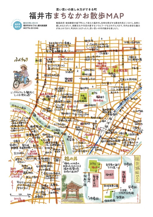
^TOP この場所に行ってみたい このマップを見る 福井県 福井市 まちなかお散歩MAP 北陸新幹線金沢~敦賀開業で注目が集まる福井市の観光情報です。福井の観光名所・おいしいグルメ・歴史・自然・文化など映えスポットへ行ってみませんか。福井旅行にデジタルマップ活用して楽しく街歩き。ひとり旅から女子旅行まで、日帰りでも宿泊でも利用可能です。旅行には外せないフォトジェニックなスポットもあるよ。 経路を探す(Google Maps) 体験スポット(福井市) あわら芸妓 お座敷列車 あわら温泉で今も現役で活躍している芸妓さんがえちぜん鉄道の車内にて舞を披露します。また、プチお座敷体験としてトラトラやはし拳などを行うほか芸妓さんとの記念撮影タイムや、えちぜん鉄道から見えるのどかな風景を車窓から楽しんでいただけます。 ホームページはこちら --> そば食べ歩きクーポン券/JR西日本連携商品 ■JTRweb経由での販売■福井県では、県産そばの流通促進と消費拡大を目的として、1年を通して福井県で生産された福井在来種のそばを100%使用しているそば店を「おいしい福井県産そば使用店」として認証しています。店ごとに異なる福井県産そばの個性を食べ歩きしてみてください。 ホームページはこちら 関西エリアパス ■JTRweb経由での販売■短期滞在の訪日外国人のお客様がご利用いただけるきっぷです。 ■自由周遊区間内の特急「はるか」号、普通列車(新快速・快速を含む)や西日本ジェイアールバスが1~4日間乗り放題です。 ※最大2列車まで特急「はるか」号の普通車指定席がご利用いただけます。■レンタサイクル「駅リンくん」もご利用いただけます。■京阪電鉄、京都市営地下鉄、阪急電鉄の1日乗車券の引換券も付随しています。 ホームページはこちら 関西ワイドエリアパス 訪日外国人向けの5日間有効のきっぷで、山陽新幹線や特急列車、普通列車、地方鉄道、バスが自由に利用できます。最大6本まで普通車指定席が利用可能で、事前予約が必要です。 ホームページはこちら 楽しい福井パス ■JTRweb経由での販売■複数の観光施設を1枚のQRコードで周遊できます。北陸新幹線が延伸する福井県内の観光名所やグルメ、お城など多様な施設をお得に周遊できますので、是非ご利用ください! ホームページはこちら 関西・北陸エリアパス ●JTRwebでの販売●短期滞在の訪日外国人のお客様がご利用いただける きっぷです。●自由周遊区間内の北陸新幹線、山陽新幹線、特急列車、普通 列車(新快速・快速含む)、あいの風とやま鉄道、IRいしかわ鉄道、ハピライン ふくい、のと鉄道、京都丹後鉄道、和歌山電鐵、西日本ジェイアールバスが7 日間乗り放題です。●普通車指定席が何度でもご利用いただけます。(指定席 をご利用の際は、必ず事前に指定席を予約してからご乗車ください)●レンタサ イクル「駅リンくん」もご利用いただけます(おとなのみ)。 ホームページはこちら 関西・広島エリアパス ●JTRwebでの販売●短期滞在の訪日外国人のお客様がご利用いただけるきっぷです。 ●自由周遊区間内の山陽新幹線、特急列車、普通列車(新快速・快速含む)、京都丹後鉄道、和歌山電鐵、西日本ジェイアールバス、JRバス中国、JR西日本宮島フェリーが5日間乗り放題です。 ●普通車指定席が何度でもご利用いただけます。(指定席をご利用の際は、必ず事前に指定席を予約してからご乗車ください。)●レンタサイクル「駅リンくん」もご利用いただけます(おとなのみ)。 ホームページはこちら 関西・山陰エリアパス ●JTRwebでの販売●短期滞在の訪日外国人のお客様がご利用いただけるきっぷです。 ●自由周遊区間内の山陽新幹線、特急列車、普通列車(新快速・快速含む)、京都丹後鉄道、智頭急行、西日本ジェイアールバスが7日間乗り放題です。 ●普通車指定席が何度でもご利用いただけます。(指定席をご利用の際は、必ず事前に指定席を予約してからご乗車ください。) ●レンタサイクル「駅リンくん」もご利用いただけます(おとなのみ)。 ホームページはこちら

^TOP この場所に行ってみたい このマップを見る 福井県 敦賀市 港 敦賀観光 まち歩きマップ 「銀河鉄道999」と「宇宙戦艦ヤマト」に出会える街・敦賀敦賀駅前、本町一丁目、2丁目のシンボルロードのアーケイド沿いには、敦賀港開港100周年記念事業の一環として制作された「宇宙戦艦ヤマト」「銀河鉄道999」のキャラクターのモニュメントにはそれぞれタイトルが付けられ"港の街" "鉄道の街"を表現し、敦賀市のシンボルとして観光客の皆さんを出迎えます。 経路を探す(Google Maps) 体験スポット(敦賀市) 「サステナつるが」おぼろ昆布手すき体験 敦賀は古くから食材の集積港で、昆布が主要な産物でした。手すきおぼろ昆布は全国の80%を生産し、職人の技が支えています。市内の職人から昆布かきを学び、体験できます。 ホームページはこちら 「サステナつるが」敦賀真鯛一本釣り・捌き体験 敦賀が誇るブランド魚「敦賀真鯛」がいる専用筏へ船でいき、そこで敦賀真鯛の一本釣りを体験していただきます。その後、鯛のさばき方をお教えいただき、三枚おろし体験の後、さばきたての鯛のお刺身を実食頂く贅沢な体験です。 ホームページはこちら 「サステナつるが」クリーンビーチ・アップサイクル体験 敦賀市でビーチクリーン活動を行う団体「TEAM CLEAN BLUE(TCB)」と一緒に敦賀の海でビーチクリーンを体験してみましょう。旅先の海での清掃体験は、きっと清々しい気持ちにさせてくれるはずです。アップサイクル体験では、海洋ゴミを使ったレジンアクセサリー作りなどが体験できます。 ホームページはこちら 関西エリアパス ■JTRweb経由での販売■短期滞在の訪日外国人のお客様がご利用いただけるきっぷです。 ■自由周遊区間内の特急「はるか」号、普通列車(新快速・快速を含む)や西日本ジェイアールバスが1~4日間乗り放題です。 ※最大2列車まで特急「はるか」号の普通車指定席がご利用いただけます。■レンタサイクル「駅リンくん」もご利用いただけます。■京阪電鉄、京都市営地下鉄、阪急電鉄の1日乗車券の引換券も付随しています。 ホームページはこちら 関西ワイドエリアパス 訪日外国人向けの5日間有効のきっぷで、山陽新幹線や特急列車、普通列車、地方鉄道、バスが自由に利用できます。最大6本まで普通車指定席が利用可能で、事前予約が必要です。 ホームページはこちら 楽しい福井パス ■JTRweb経由での販売■複数の観光施設を1枚のQRコードで周遊できます。北陸新幹線が延伸する福井県内の観光名所やグルメ、お城など多様な施設をお得に周遊できますので、是非ご利用ください! ホームページはこちら 関西・北陸エリアパス ●JTRwebでの販売●短期滞在の訪日外国人のお客様がご利用いただける きっぷです。●自由周遊区間内の北陸新幹線、山陽新幹線、特急列車、普通 列車(新快速・快速含む)、あいの風とやま鉄道、IRいしかわ鉄道、ハピライン ふくい、のと鉄道、京都丹後鉄道、和歌山電鐵、西日本ジェイアールバスが7 日間乗り放題です。●普通車指定席が何度でもご利用いただけます。(指定席 をご利用の際は、必ず事前に指定席を予約してからご乗車ください)●レンタサ イクル「駅リンくん」もご利用いただけます(おとなのみ)。 ホームページはこちら 関西・広島エリアパス ●JTRwebでの販売●短期滞在の訪日外国人のお客様がご利用いただけるきっぷです。 ●自由周遊区間内の山陽新幹線、特急列車、普通列車(新快速・快速含む)、京都丹後鉄道、和歌山電鐵、西日本ジェイアールバス、JRバス中国、JR西日本宮島フェリーが5日間乗り放題です。 ●普通車指定席が何度でもご利用いただけます。(指定席をご利用の際は、必ず事前に指定席を予約してからご乗車ください。)●レンタサイクル「駅リンくん」もご利用いただけます(おとなのみ)。 ホームページはこちら 関西・山陰エリアパス ●JTRwebでの販売●短期滞在の訪日外国人のお客様がご利用いただけるきっぷです。 ●自由周遊区間内の山陽新幹線、特急列車、普通列車(新快速・快速含む)、京都丹後鉄道、智頭急行、西日本ジェイアールバスが7日間乗り放題です。 ●普通車指定席が何度でもご利用いただけます。(指定席をご利用の際は、必ず事前に指定席を予約してからご乗車ください。) ●レンタサイクル「駅リンくん」もご利用いただけます(おとなのみ)。 ホームページはこちら
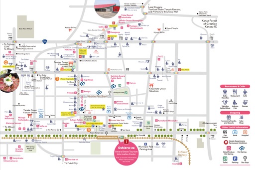
^TOP この場所に行ってみたい このマップを見る 福井県 あわら市 あわら温泉まち歩きマップ えちぜん鉄道「あわら湯のまち駅」周辺のまち歩きマップです。 経路を探す(Google Maps) 体験スポット(あわら市) あわら芸妓 お座敷列車 あわら温泉で今も現役で活躍している芸妓さんがえちぜん鉄道の車内にて舞を披露します。また、プチお座敷体験としてトラトラやはし拳などを行うほか芸妓さんとの記念撮影タイムや、えちぜん鉄道から見えるのどかな風景を車窓から楽しんでいただけます。 ホームページはこちら --> あわら温泉 満喫チケット あわら温泉の滞在時間がもっと充実したものになる、宿泊者限定のおトクなチケット このクーポンは1500円で、あわら温泉内湯めぐりと「福井いいものチョット体験」などが利用できます。 ホームページはこちら 関西エリアパス ■JTRweb経由での販売■短期滞在の訪日外国人のお客様がご利用いただけるきっぷです。 ■自由周遊区間内の特急「はるか」号、普通列車(新快速・快速を含む)や西日本ジェイアールバスが1~4日間乗り放題です。 ※最大2列車まで特急「はるか」号の普通車指定席がご利用いただけます。■レンタサイクル「駅リンくん」もご利用いただけます。■京阪電鉄、京都市営地下鉄、阪急電鉄の1日乗車券の引換券も付随しています。 ホームページはこちら 関西ワイドエリアパス 訪日外国人向けの5日間有効のきっぷで、山陽新幹線や特急列車、普通列車、地方鉄道、バスが自由に利用できます。最大6本まで普通車指定席が利用可能で、事前予約が必要です。 ホームページはこちら ランチ・スイーツめぐり クーポン あわら市内の人気店からお好みで選ぶことができ、ランチやおやつだけでなく、温泉たまごづくり体験他3つの特典付き。クーポンを使ってゆっくりあわらをお楽しみください。 ホームページはこちら 楽しい福井パス ■JTRweb経由での販売■複数の観光施設を1枚のQRコードで周遊できます。北陸新幹線が延伸する福井県内の観光名所やグルメ、お城など多様な施設をお得に周遊できますので、是非ご利用ください! ホームページはこちら 関西・北陸エリアパス ●JTRwebでの販売●短期滞在の訪日外国人のお客様がご利用いただける きっぷです。●自由周遊区間内の北陸新幹線、山陽新幹線、特急列車、普通 列車(新快速・快速含む)、あいの風とやま鉄道、IRいしかわ鉄道、ハピライン ふくい、のと鉄道、京都丹後鉄道、和歌山電鐵、西日本ジェイアールバスが7 日間乗り放題です。●普通車指定席が何度でもご利用いただけます。(指定席 をご利用の際は、必ず事前に指定席を予約してからご乗車ください)●レンタサ イクル「駅リンくん」もご利用いただけます(おとなのみ)。 ホームページはこちら 関西・広島エリアパス ●JTRwebでの販売●短期滞在の訪日外国人のお客様がご利用いただけるきっぷです。 ●自由周遊区間内の山陽新幹線、特急列車、普通列車(新快速・快速含む)、京都丹後鉄道、和歌山電鐵、西日本ジェイアールバス、JRバス中国、JR西日本宮島フェリーが5日間乗り放題です。 ●普通車指定席が何度でもご利用いただけます。(指定席をご利用の際は、必ず事前に指定席を予約してからご乗車ください。)●レンタサイクル「駅リンくん」もご利用いただけます(おとなのみ)。 ホームページはこちら 関西・山陰エリアパス ●JTRwebでの販売●短期滞在の訪日外国人のお客様がご利用いただけるきっぷです。 ●自由周遊区間内の山陽新幹線、特急列車、普通列車(新快速・快速含む)、京都丹後鉄道、智頭急行、西日本ジェイアールバスが7日間乗り放題です。 ●普通車指定席が何度でもご利用いただけます。(指定席をご利用の際は、必ず事前に指定席を予約してからご乗車ください。) ●レンタサイクル「駅リンくん」もご利用いただけます(おとなのみ)。 ホームページはこちら
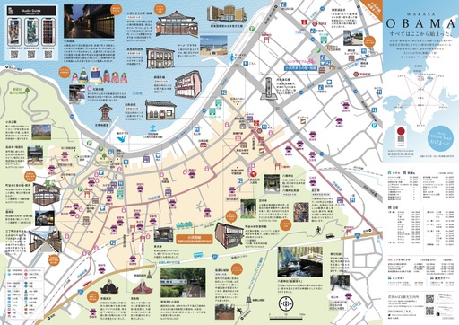
^TOP この場所に行ってみたい このマップを見る 福井県 小浜市 小浜西組散策マップ 小浜西組と呼ばれる地域は、重要伝統的建造物群保存地区に指定されていて、明治・大正・昭和の建物が残る情緒あふれる町並みです。まちあるきをしていると、まちなかに点在している地蔵堂に出会えます。地蔵堂は子どもの無病息災を願って祀られ、中には子どもがお化粧を施した「化粧地蔵」がいらっしゃいます。 経路を探す(Google Maps) 体験スポット(小浜市) 蘇洞門めぐり 蘇洞門は若狭湾国定公園内の美しい景勝地で断崖美や奇岩、洞門、洞窟が見どころで、国の名勝に指定されています。ビューポイントには「大門・小門」、「唐船島」、「夫婦亀岩」、「白糸の滝」などがあります。 ホームページはこちら 関西エリアパス ■JTRweb経由での販売■短期滞在の訪日外国人のお客様がご利用いただけるきっぷです。 ■自由周遊区間内の特急「はるか」号、普通列車(新快速・快速を含む)や西日本ジェイアールバスが1~4日間乗り放題です。 ※最大2列車まで特急「はるか」号の普通車指定席がご利用いただけます。■レンタサイクル「駅リンくん」もご利用いただけます。■京阪電鉄、京都市営地下鉄、阪急電鉄の1日乗車券の引換券も付随しています。 ホームページはこちら 関西ワイドエリアパス 訪日外国人向けの5日間有効のきっぷで、山陽新幹線や特急列車、普通列車、地方鉄道、バスが自由に利用できます。最大6本まで普通車指定席が利用可能で、事前予約が必要です。 ホームページはこちら 楽しい福井パス ■JTRweb経由での販売■複数の観光施設を1枚のQRコードで周遊できます。北陸新幹線が延伸する福井県内の観光名所やグルメ、お城など多様な施設をお得に周遊できますので、是非ご利用ください! ホームページはこちら 関西・北陸エリアパス ●JTRwebでの販売●短期滞在の訪日外国人のお客様がご利用いただける きっぷです。●自由周遊区間内の北陸新幹線、山陽新幹線、特急列車、普通 列車(新快速・快速含む)、あいの風とやま鉄道、IRいしかわ鉄道、ハピライン ふくい、のと鉄道、京都丹後鉄道、和歌山電鐵、西日本ジェイアールバスが7 日間乗り放題です。●普通車指定席が何度でもご利用いただけます。(指定席 をご利用の際は、必ず事前に指定席を予約してからご乗車ください)●レンタサ イクル「駅リンくん」もご利用いただけます(おとなのみ)。 ホームページはこちら 関西・広島エリアパス ●JTRwebでの販売●短期滞在の訪日外国人のお客様がご利用いただけるきっぷです。 ●自由周遊区間内の山陽新幹線、特急列車、普通列車(新快速・快速含む)、京都丹後鉄道、和歌山電鐵、西日本ジェイアールバス、JRバス中国、JR西日本宮島フェリーが5日間乗り放題です。 ●普通車指定席が何度でもご利用いただけます。(指定席をご利用の際は、必ず事前に指定席を予約してからご乗車ください。)●レンタサイクル「駅リンくん」もご利用いただけます(おとなのみ)。 ホームページはこちら 関西・山陰エリアパス ●JTRwebでの販売●短期滞在の訪日外国人のお客様がご利用いただけるきっぷです。 ●自由周遊区間内の山陽新幹線、特急列車、普通列車(新快速・快速含む)、京都丹後鉄道、智頭急行、西日本ジェイアールバスが7日間乗り放題です。 ●普通車指定席が何度でもご利用いただけます。(指定席をご利用の際は、必ず事前に指定席を予約してからご乗車ください。) ●レンタサイクル「駅リンくん」もご利用いただけます(おとなのみ)。 ホームページはこちら
 滋賀県
滋賀県

^TOP この場所に行ってみたい このマップを見る 滋賀県 滋賀県全域マップ 滋賀県全域の観光スポットを網羅したマップです。琵琶湖を中心に、歴史ある古城や古寺、美しい自然が点在し、四季折々の風景を楽しむことができます。また、湖畔のレジャースポットや温泉地、地元の特産品を味わえる飲食店など、幅広いアクティビティが魅力です。地域の歴史や文化に触れながら、美しい風景を満喫したい方におすすめのガイドとなっています。 経路を探す(Google Maps) 体験スポット(滋賀県全域)
^TOP この場所に行ってみたい このマップを見る 滋賀県 長浜市 木之本まち歩きマップ 滋賀県長浜市木之本のまち歩きマップをデジタルマップにしました。つるやパンや富田酒造、木之本地蔵院などの主要グルメスポットや観光名所をピンで表記しています。 経路を探す(Google Maps) 体験スポット(長浜市)

^TOP この場所に行ってみたい このマップを見る 滋賀県 甲賀市 滋賀県甲賀市観光マップ 滋賀県甲賀市は忍者発祥の地!京都駅から電車・車どちらでも約50分でお越しいただけます。この観光デジタルマップを使えば、マップ上で甲賀市の観光スポットに関する情報が表示されるほか、GPSを使った現在地情報の表示、マップの切替ができて便利!各施設のイベント情報など旬な情報も随時更新して紹介していきます。 経路を探す(Google Maps) 体験スポット(甲賀市)
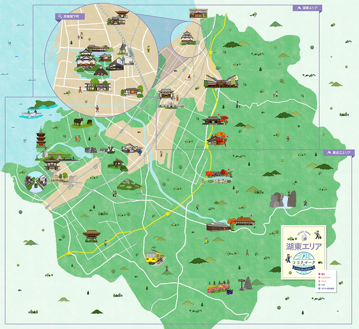
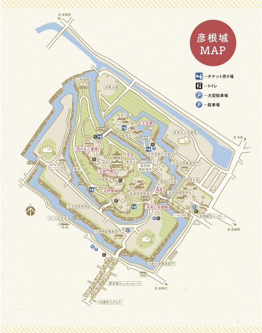
^TOP この場所に行ってみたい このマップを見る 滋賀県 彦根市 湖東エリア観光マップ JTB旅館ホテル連盟びわ湖支部がプロデュース!Strolyを使ったデジタル散策マップで、滋賀・近江の魅力的なスポットを気軽にチェックできるようになりました。滋賀の観光名所や見どころ、レストラン、宿泊施設情報が、スマホやPCなどオンラインで簡単に調べられるから、今いる場所から行ける観光スポットや気になっていた場所にスムーズに足を運べます。第二弾は“湖東エリア”。地元の宿泊施設スタッフおすすめの滋賀・びわ湖周辺観光情報を、ぜひイラストマップで楽しんでみてください。 経路を探す(Google Maps) 体験スポット(彦根市)
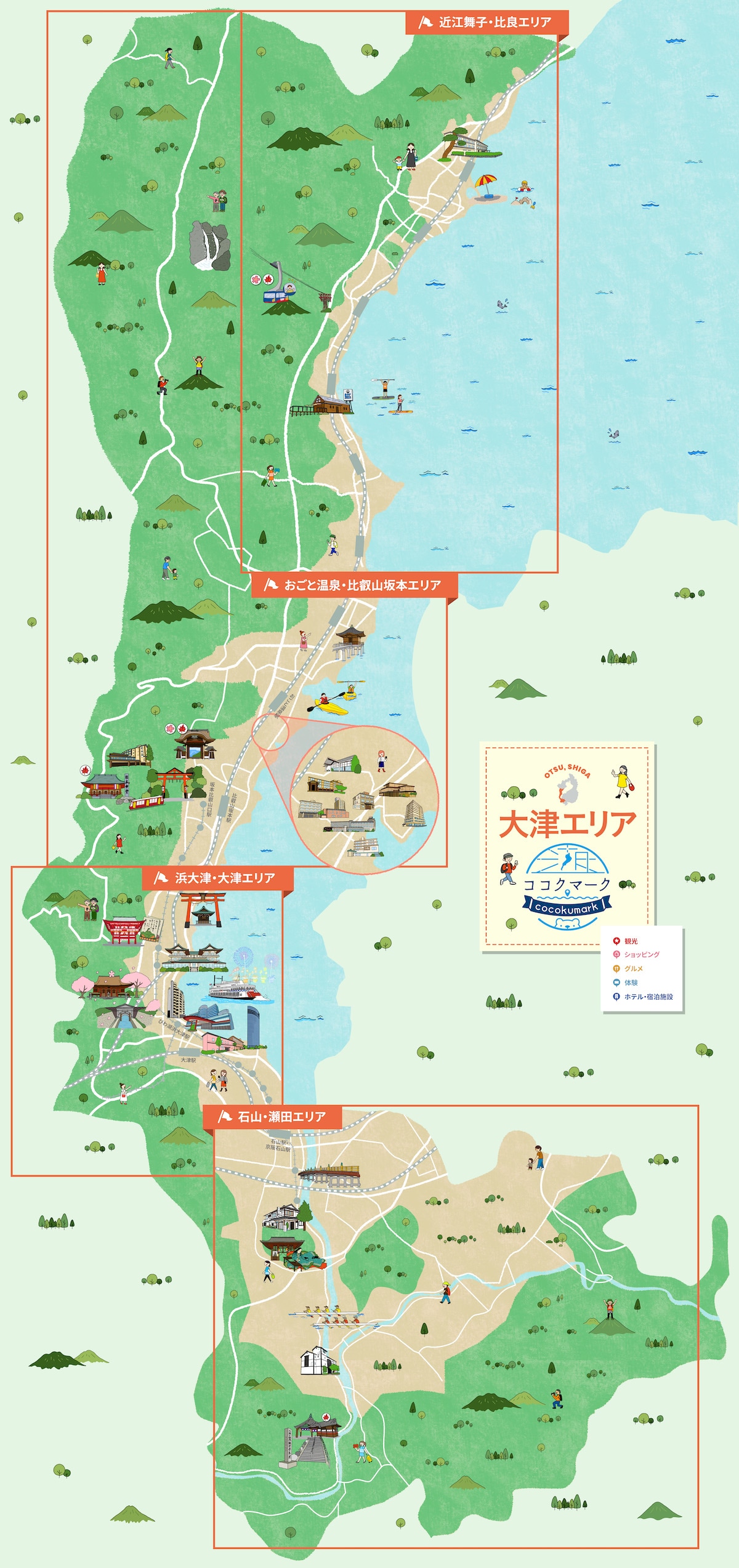
^TOP この場所に行ってみたい このマップを見る 滋賀県 大津市 大津エリア観光マップ JTB旅館ホテル連盟びわ湖支部がプロデュース!Strolyを使ったデジタル散策マップで、滋賀・近江の魅力的なスポットを気軽にチェックできるようになりました。滋賀の観光名所や見どころ、レストラン、宿泊施設情報が、スマホやPCなどオンラインで簡単に調べられるから、今いる場所から行ける観光スポットや気になっていた場所にスムーズに足を運べます。第一弾は“大津エリア”。地元の宿泊施設スタッフおすすめの滋賀・びわ湖周辺観光情報を、ぜひイラストマップで楽しんでみてください。 経路を探す(Google Maps) 体験スポット(大津市)
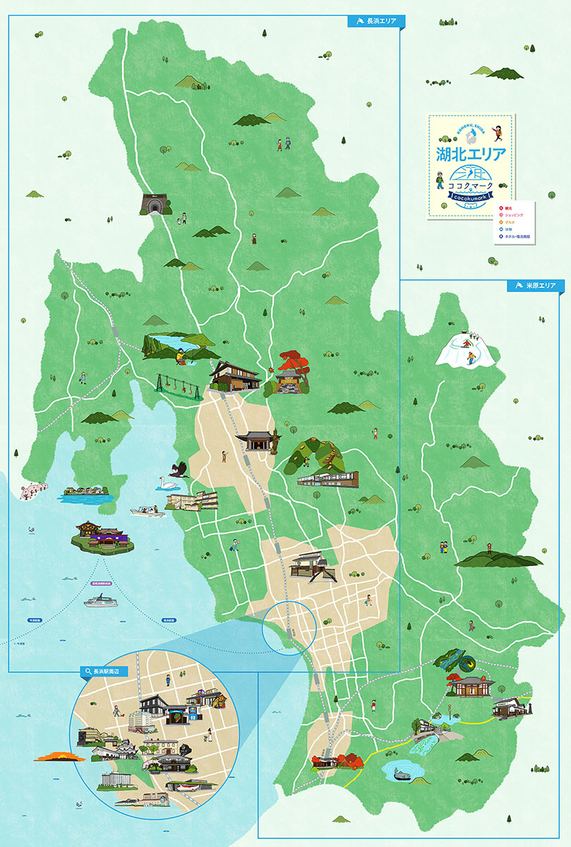
^TOP この場所に行ってみたい このマップを見る 滋賀県 長浜市 湖北エリア観光マップ JTB旅館ホテル連盟びわ湖支部がプロデュース!Strolyを使ったデジタル散策マップで、滋賀・近江の魅力的なスポットを気軽にチェックできるようになりました。滋賀の観光名所や見どころ、レストラン、宿泊施設情報が、スマホやPCなどオンラインで簡単に調べられるから、今いる場所から行ける観光スポットや気になっていた場所にスムーズに足を運べます。第三弾は“湖北エリア”。地元の宿泊施設スタッフおすすめの滋賀・びわ湖周辺観光情報を、ぜひイラストマップで楽しんでみてください。 経路を探す(Google Maps) 体験スポット(長浜市)
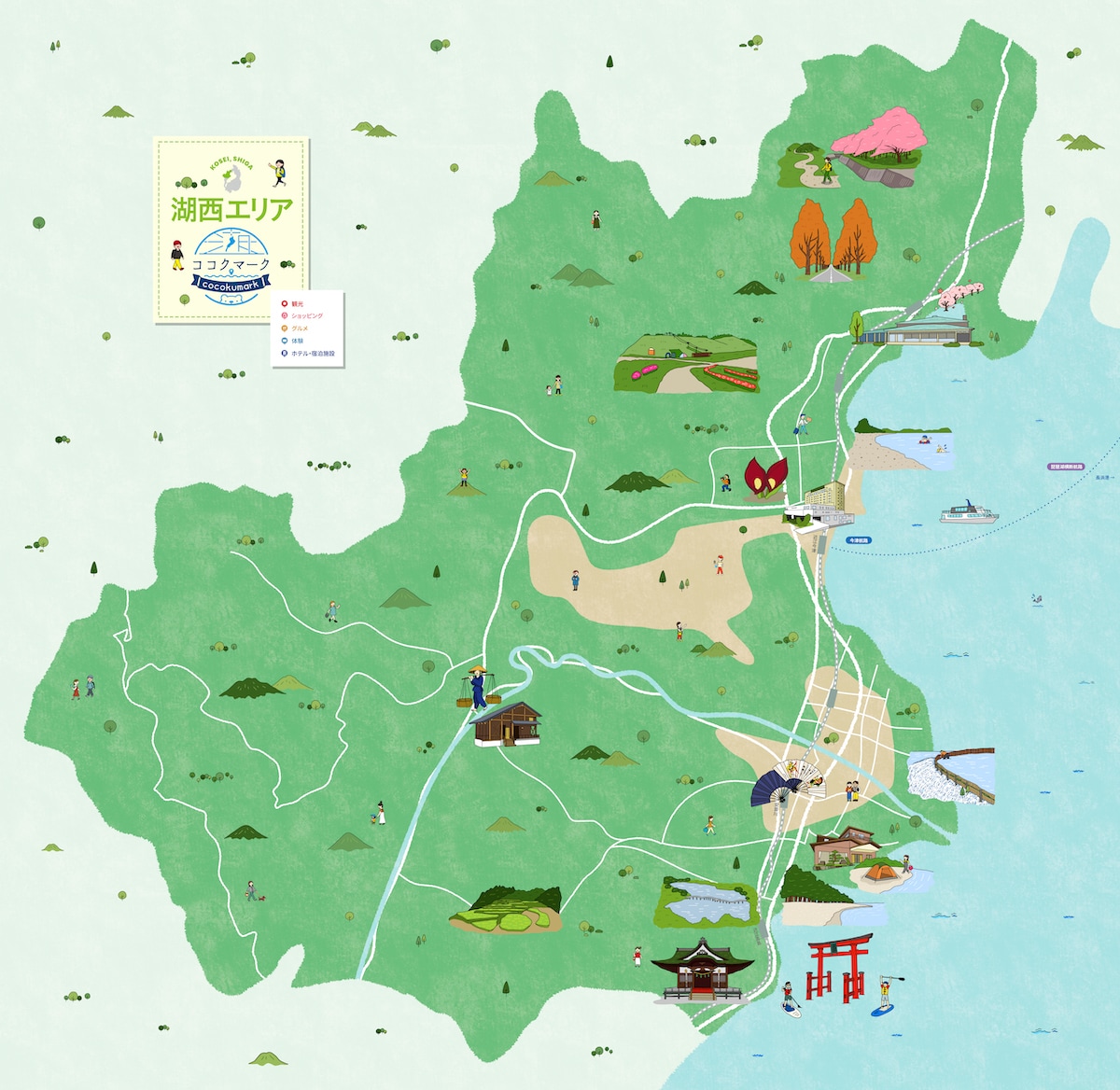
^TOP この場所に行ってみたい このマップを見る 滋賀県 高島市 湖西エリア観光マップ JTB旅館ホテル連盟びわ湖支部がプロデュース! Strolyを使ったデジタル散策マップで、滋賀・湖西の魅力的なスポットを気軽にチェックできるようになりました。 滋賀の観光名所や見どころ、レストラン、宿泊施設情報が、スマホやPCなどオンラインで簡単に調べられるから、今いる場所から行ける観光スポットや気になっていた場所にスムーズに足を運べます。 第5弾は“湖西エリア”。地元の宿泊施設スタッフおすすめの滋賀・びわ湖周辺観光情報を、ぜひイラストマップで楽しんでみてください。 経路を探す(Google Maps) 体験スポット(高島市)
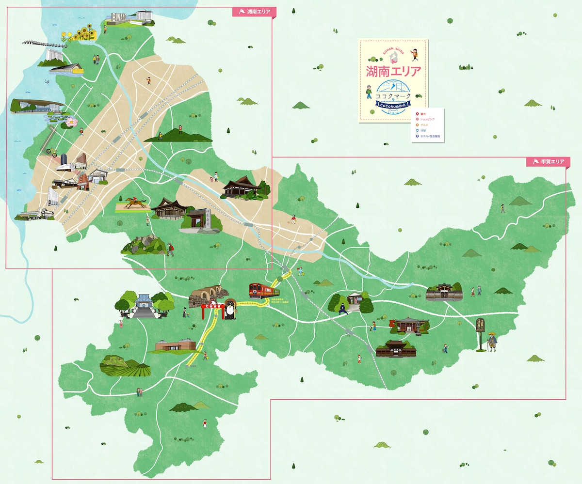
^TOP この場所に行ってみたい このマップを見る 滋賀県 草津市 湖南エリア観光マップ JTB旅館ホテル連盟びわ湖支部がプロデュース! Strolyを使ったデジタル散策マップで、滋賀・近江の魅力的なスポットを気軽にチェックできるようになりました。 滋賀の観光名所や見どころ、レストラン、宿泊施設情報が、スマホやPCなどオンラインで簡単に調べられるから、今いる場所から行ける観光スポットや気になっていた場所にスムーズに足を運べます。 第四弾は“湖南エリア”。地元の宿泊施設スタッフおすすめの滋賀・びわ湖周辺観光情報を、ぜひイラストマップで楽しんでみてください。 経路を探す(Google Maps) 体験スポット(草津市)
 徳島県
徳島県
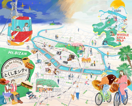
^TOP この場所に行ってみたい このマップを見る 徳島県 徳島市 Dig the LOCALとくしまシティ〜COFFEE&BAKERY〜 StrolyプロデュースのDig the LOCAL、第一弾は徳島県徳島市。「わくわく実感!水都とくしま」としてブランドステートメントを掲げる徳島市では、バラエティに富んだアクティビティが人気です。実は喫茶文化が根付いており、都道府県別ランキングで1人あたりのコーヒー消費額1位(2020年)や人口10万人あたりのパン屋の店舗数1位(2018年まで8年連続)の実績があります!今回はそんな徳島市の喫茶文化を新たな魅力の発信として徳島市ローカルの喫茶店・コーヒー店・パン屋・アクティビティを体験できる場所を紹介!徳島市を一日中堪能できるマップメディアです。冬の徳島市で心温まるほっこり旅を是非お楽しみください。 経路を探す(Google Maps) 体験スポット(徳島市) 関西空港リムジンバス乗車券 関西国際空港と各主要都市を乗り換え不要で直結! 空港へのアクセスに最適なリムジンバスです。 ホームページはこちら 歴史を物語る機場で、伝統工芸阿波しじら織を体験 しじらとは、織物の表面にできる細かいしわのことです。 昭和初期の機械が並ぶ機場は、タイムスリップしたかのような雰囲気。 「機(はた)織り」や「糸捌き」を通して、しじら織の歴史を感じて下さい。 ホームページはこちら 日本人の感性が息づく伝統芸能「阿波人形浄瑠璃」の魅力 - 徳島県立阿波十郎兵衛屋敷 徳島県立阿波十郎兵衛屋敷は、阿波人形浄瑠璃の拠点施設として、農村舞台をモデルにつくられた舞台で毎日公演を行うとともに、映像や展示室、日本庭園、ショップもあり、阿波人形浄瑠璃の総合的な魅力に触れることができます。 ホームページはこちら
^TOP この場所に行ってみたい このマップを見る 徳島県 美波町 ひわさ散策絵地図 徳島県の南部に位置する美波町にある日和佐の見どころをギュギュっと地図に書き込んだマップです。 ゆっくりとした時間が流れる日和佐を散策してください。 経路を探す(Google Maps) 体験スポット(美波町) 関西空港リムジンバス乗車券 関西国際空港と各主要都市を乗り換え不要で直結! 空港へのアクセスに最適なリムジンバスです。 ホームページはこちら 四国八十八箇所第23番札所・薬王寺での「写経体験」 般若心経はとても短いお経ですが、文殊菩薩・般若菩薩の智慧が詰まったたいへん功徳・ご利益の大きなお経です。お経は見るまた聞くだけでもご利益があるとされており、口でお唱えしたり浄書するお写経の功徳は計り知れません。 心静かに写経用紙と向き合い一文字一文字が仏さまであるという気持ちでゆっくりとお写経してみてはいかがでしょうか。 ホームページはこちら 四国八十八箇所第23番札所・薬王寺本坊特別内拝 弘法大師42歳のとき、平城上皇の勅命によって本尊厄除薬師如来を刻んで開基した阿波の国薬王寺は、四国八十八ヶ所第23番の霊場であり、厄除根本御祈願所として全国にその名を知られています。本坊内を特別に内拝していただきます。 ホームページはこちら
 鳥取県
鳥取県
^TOP この場所に行ってみたい このマップを見る 鳥取県 米子市 米子市街地案内マップ 米子市内の米子城跡や城下町観光におすすめのマップです。 経路を探す(Google Maps) 体験スポット(米子市) Discover Another Japan Pass/JR西日本連携商品 ■JTRweb経由での販売■外国人観光客向けのお得な山陰山陽周遊パスです。3日券(72時間有効)、5日券(120時間有効)と7日券(168時間有効)から選べ、関西エリアの観光施設も含まれています。アプリ形式なので、引き換える必要がありません。 ホームページはこちら 関西ワイドエリアパス 訪日外国人向けの5日間有効のきっぷで、山陽新幹線や特急列車、普通列車、地方鉄道、バスが自由に利用できます。最大6本まで普通車指定席が利用可能で、事前予約が必要です。 ホームページはこちら まちなか観光ガイドと和文化体験メニュー 「米子まちなか観光案内所」は城下町の観光拠点で、観光ガイドや和文化体験を提供。お土産作りもari、伝統工芸、お茶、和菓子、利き酒、和服着付け、陶芸、折紙和紙づくり、座禅など多彩なプログラムがあり ホームページはこちら ジオパークと美肌の湯 大自然に抱かれる癒し旅へ ・四季折々の美しさを讃えた大山国立公園 ・美肌の湯として名高い大山の温泉 ・大山ブリュワリーでは地の恵みを味わう地ビール飲み放題 ホームページはこちら --> 楽しい鳥取パス ■JTRwebでの販売■複数の観光施設を1枚のQRコードで周遊できます。7日間の有効期間の中で3施設/5施設を選択できます。グルメや観光名所など多様な施設をお得に周遊できますので、是非ご利用ください! ホームページはこちら 関西・北陸エリアパス ●JTRwebでの販売●短期滞在の訪日外国人のお客様がご利用いただける きっぷです。●自由周遊区間内の北陸新幹線、山陽新幹線、特急列車、普通 列車(新快速・快速含む)、あいの風とやま鉄道、IRいしかわ鉄道、ハピライン ふくい、のと鉄道、京都丹後鉄道、和歌山電鐵、西日本ジェイアールバスが7 日間乗り放題です。●普通車指定席が何度でもご利用いただけます。(指定席 をご利用の際は、必ず事前に指定席を予約してからご乗車ください)●レンタサ イクル「駅リンくん」もご利用いただけます(おとなのみ)。 ホームページはこちら 関西・広島エリアパス ●JTRwebでの販売●短期滞在の訪日外国人のお客様がご利用いただけるきっぷです。 ●自由周遊区間内の山陽新幹線、特急列車、普通列車(新快速・快速含む)、京都丹後鉄道、和歌山電鐵、西日本ジェイアールバス、JRバス中国、JR西日本宮島フェリーが5日間乗り放題です。 ●普通車指定席が何度でもご利用いただけます。(指定席をご利用の際は、必ず事前に指定席を予約してからご乗車ください。)●レンタサイクル「駅リンくん」もご利用いただけます(おとなのみ)。 ホームページはこちら 関西・山陰エリアパス ●JTRwebでの販売●短期滞在の訪日外国人のお客様がご利用いただけるきっぷです。 ●自由周遊区間内の山陽新幹線、特急列車、普通列車(新快速・快速含む)、京都丹後鉄道、智頭急行、西日本ジェイアールバスが7日間乗り放題です。 ●普通車指定席が何度でもご利用いただけます。(指定席をご利用の際は、必ず事前に指定席を予約してからご乗車ください。) ●レンタサイクル「駅リンくん」もご利用いただけます(おとなのみ)。 ホームページはこちら
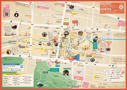
^TOP この場所に行ってみたい このマップを見る 鳥取県 倉吉市 白壁土蔵群まち歩きMAP in 倉吉 倉吉市内のおすすめコースが2つ書かれたマップです。 滞在時間に合わせて、ゆっくりと市内を巡ってください。 経路を探す(Google Maps) 体験スポット(倉吉市) Discover Another Japan Pass/JR西日本連携商品 ■JTRweb経由での販売■外国人観光客向けのお得な山陰山陽周遊パスです。3日券(72時間有効)、5日券(120時間有効)と7日券(168時間有効)から選べ、関西エリアの観光施設も含まれています。アプリ形式なので、引き換える必要がありません。 ホームページはこちら 関西ワイドエリアパス 訪日外国人向けの5日間有効のきっぷで、山陽新幹線や特急列車、普通列車、地方鉄道、バスが自由に利用できます。最大6本まで普通車指定席が利用可能で、事前予約が必要です。 ホームページはこちら くらよし利き酒クーポン 江戸時代から明治時代に建てられた商家や蔵が並ぶ白壁土蔵群では地元で醸造された日本酒やワイン、クラフトビールなどの地酒が楽しめるお店が並んでいます。「くらよし利き酒クーポン」はそんなこだわりの地元産のお酒を指定店舗で利き酒を楽しめるクーポンです。お好みの地元産のお酒をちょこっとずつお楽しみ下さい! ホームページはこちら くらよし利き酒クーポン 江戸時代から明治時代に建てられた商家や蔵が並ぶ白壁土蔵群では地元で醸造された日本酒やワイン、クラフトビールなどの地酒が楽しめるお店が並んでいます。「くらよし利き酒クーポン」はそんなこだわりの地元産のお酒を指定店舗で利き酒を楽しめるクーポンです。お好みの地元産のお酒をちょこっとずつお楽しみ下さい! ホームページはこちら --> 倉吉絣でまち歩き 江戸時代から伝わる、倉吉の伝統工芸「倉吉絣」は、絵をそのまま織り込んだような精巧で美しい模様が特徴です。この美しい柄の着物をまとい、白壁土蔵群の町並みをそぞろ歩いてみませんか?男性も体験できます。 ホームページはこちら 楽しい鳥取パス ■JTRwebでの販売■複数の観光施設を1枚のQRコードで周遊できます。7日間の有効期間の中で3施設/5施設を選択できます。グルメや観光名所など多様な施設をお得に周遊できますので、是非ご利用ください! ホームページはこちら 関西・北陸エリアパス ●JTRwebでの販売●短期滞在の訪日外国人のお客様がご利用いただける きっぷです。●自由周遊区間内の北陸新幹線、山陽新幹線、特急列車、普通 列車(新快速・快速含む)、あいの風とやま鉄道、IRいしかわ鉄道、ハピライン ふくい、のと鉄道、京都丹後鉄道、和歌山電鐵、西日本ジェイアールバスが7 日間乗り放題です。●普通車指定席が何度でもご利用いただけます。(指定席 をご利用の際は、必ず事前に指定席を予約してからご乗車ください)●レンタサ イクル「駅リンくん」もご利用いただけます(おとなのみ)。 ホームページはこちら 関西・広島エリアパス ●JTRwebでの販売●短期滞在の訪日外国人のお客様がご利用いただけるきっぷです。 ●自由周遊区間内の山陽新幹線、特急列車、普通列車(新快速・快速含む)、京都丹後鉄道、和歌山電鐵、西日本ジェイアールバス、JRバス中国、JR西日本宮島フェリーが5日間乗り放題です。 ●普通車指定席が何度でもご利用いただけます。(指定席をご利用の際は、必ず事前に指定席を予約してからご乗車ください。)●レンタサイクル「駅リンくん」もご利用いただけます(おとなのみ)。 ホームページはこちら 関西・山陰エリアパス ●JTRwebでの販売●短期滞在の訪日外国人のお客様がご利用いただけるきっぷです。 ●自由周遊区間内の山陽新幹線、特急列車、普通列車(新快速・快速含む)、京都丹後鉄道、智頭急行、西日本ジェイアールバスが7日間乗り放題です。 ●普通車指定席が何度でもご利用いただけます。(指定席をご利用の際は、必ず事前に指定席を予約してからご乗車ください。) ●レンタサイクル「駅リンくん」もご利用いただけます(おとなのみ)。 ホームページはこちら
^TOP この場所に行ってみたい このマップを見る 鳥取県 鳥取市 鳥取城下之図[江戸前期] この図は近世前期の鳥取城下町の形がよくわかる図である。鳥取城下全域を描き、武家地(朱色)・町人地(灰色)・寺社地(白)を色分けする。慶安3(1650)年に勧請された鳥取東照宮と、そこに至る道路が貼紙で記されていることから、年代が比定される。法量:285×320cm。 経路を探す(Google Maps) 体験スポット(鳥取市) Discover Another Japan Pass/JR西日本連携商品 ■JTRweb経由での販売■外国人観光客向けのお得な山陰山陽周遊パスです。3日券(72時間有効)、5日券(120時間有効)と7日券(168時間有効)から選べ、関西エリアの観光施設も含まれています。アプリ形式なので、引き換える必要がありません。 ホームページはこちら 関西ワイドエリアパス 訪日外国人向けの5日間有効のきっぷで、山陽新幹線や特急列車、普通列車、地方鉄道、バスが自由に利用できます。最大6本まで普通車指定席が利用可能で、事前予約が必要です。 ホームページはこちら 楽しい鳥取パス ■JTRwebでの販売■複数の観光施設を1枚のQRコードで周遊できます。7日間の有効期間の中で3施設/5施設を選択できます。グルメや観光名所など多様な施設をお得に周遊できますので、是非ご利用ください! ホームページはこちら 関西・北陸エリアパス ●JTRwebでの販売●短期滞在の訪日外国人のお客様がご利用いただける きっぷです。●自由周遊区間内の北陸新幹線、山陽新幹線、特急列車、普通 列車(新快速・快速含む)、あいの風とやま鉄道、IRいしかわ鉄道、ハピライン ふくい、のと鉄道、京都丹後鉄道、和歌山電鐵、西日本ジェイアールバスが7 日間乗り放題です。●普通車指定席が何度でもご利用いただけます。(指定席 をご利用の際は、必ず事前に指定席を予約してからご乗車ください)●レンタサ イクル「駅リンくん」もご利用いただけます(おとなのみ)。 ホームページはこちら 関西・広島エリアパス ●JTRwebでの販売●短期滞在の訪日外国人のお客様がご利用いただけるきっぷです。 ●自由周遊区間内の山陽新幹線、特急列車、普通列車(新快速・快速含む)、京都丹後鉄道、和歌山電鐵、西日本ジェイアールバス、JRバス中国、JR西日本宮島フェリーが5日間乗り放題です。 ●普通車指定席が何度でもご利用いただけます。(指定席をご利用の際は、必ず事前に指定席を予約してからご乗車ください。)●レンタサイクル「駅リンくん」もご利用いただけます(おとなのみ)。 ホームページはこちら 関西・山陰エリアパス ●JTRwebでの販売●短期滞在の訪日外国人のお客様がご利用いただけるきっぷです。 ●自由周遊区間内の山陽新幹線、特急列車、普通列車(新快速・快速含む)、京都丹後鉄道、智頭急行、西日本ジェイアールバスが7日間乗り放題です。 ●普通車指定席が何度でもご利用いただけます。(指定席をご利用の際は、必ず事前に指定席を予約してからご乗車ください。) ●レンタサイクル「駅リンくん」もご利用いただけます(おとなのみ)。 ホームページはこちら
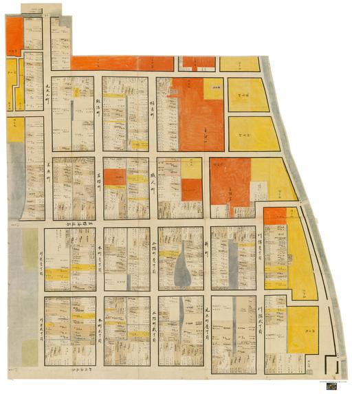
^TOP この場所に行ってみたい このマップを見る 鳥取県 鳥取市 鳥取城下町大切図 川内上 [天保14年(1843)] 袋川と外堀との間に区画された町割のうち、智頭街道よりも東側(袋川の上流側)を描いた絵図。この大切図には16町の町人町と、その東側に配置された寺町(朱色)、総構である袋川沿いや町人町に点在する武家の拝領屋敷(黄色)が描かれている。このうち町人町は、一軒ごとに表間口と奥行の間数を記し、その所有者を記載している。町人町の土地所有状況を記すのは、表間数を指数とする町役の賦課・十分一銀(町屋の売買に際して、その価格の10分の1を徴収する)などを算出するためと推定される。しがたって、本図によって現住者の情報を得ることはできない。また本図には所々に所有者の変更を示す貼り紙があり、その下限は明治2年(1869)である。このことから、土地管理の基礎資料として町会所などで長期にわたって利用されていた状況がうかがえる。なお、大切図は、本図を含めて6枚に分けて城下町全体の町人町を描いており、その構成は、川内上、川内下、江崎・上町・立川、川外上、川外下、新品治となっている。 経路を探す(Google Maps) 体験スポット(鳥取市) Discover Another Japan Pass/JR西日本連携商品 ■JTRweb経由での販売■外国人観光客向けのお得な山陰山陽周遊パスです。3日券(72時間有効)、5日券(120時間有効)と7日券(168時間有効)から選べ、関西エリアの観光施設も含まれています。アプリ形式なので、引き換える必要がありません。 ホームページはこちら 関西ワイドエリアパス 訪日外国人向けの5日間有効のきっぷで、山陽新幹線や特急列車、普通列車、地方鉄道、バスが自由に利用できます。最大6本まで普通車指定席が利用可能で、事前予約が必要です。 ホームページはこちら 楽しい鳥取パス ■JTRwebでの販売■複数の観光施設を1枚のQRコードで周遊できます。7日間の有効期間の中で3施設/5施設を選択できます。グルメや観光名所など多様な施設をお得に周遊できますので、是非ご利用ください! ホームページはこちら 関西・北陸エリアパス ●JTRwebでの販売●短期滞在の訪日外国人のお客様がご利用いただける きっぷです。●自由周遊区間内の北陸新幹線、山陽新幹線、特急列車、普通 列車(新快速・快速含む)、あいの風とやま鉄道、IRいしかわ鉄道、ハピライン ふくい、のと鉄道、京都丹後鉄道、和歌山電鐵、西日本ジェイアールバスが7 日間乗り放題です。●普通車指定席が何度でもご利用いただけます。(指定席 をご利用の際は、必ず事前に指定席を予約してからご乗車ください)●レンタサ イクル「駅リンくん」もご利用いただけます(おとなのみ)。 ホームページはこちら 関西・広島エリアパス ●JTRwebでの販売●短期滞在の訪日外国人のお客様がご利用いただけるきっぷです。 ●自由周遊区間内の山陽新幹線、特急列車、普通列車(新快速・快速含む)、京都丹後鉄道、和歌山電鐵、西日本ジェイアールバス、JRバス中国、JR西日本宮島フェリーが5日間乗り放題です。 ●普通車指定席が何度でもご利用いただけます。(指定席をご利用の際は、必ず事前に指定席を予約してからご乗車ください。)●レンタサイクル「駅リンくん」もご利用いただけます(おとなのみ)。 ホームページはこちら 関西・山陰エリアパス ●JTRwebでの販売●短期滞在の訪日外国人のお客様がご利用いただけるきっぷです。 ●自由周遊区間内の山陽新幹線、特急列車、普通列車(新快速・快速含む)、京都丹後鉄道、智頭急行、西日本ジェイアールバスが7日間乗り放題です。 ●普通車指定席が何度でもご利用いただけます。(指定席をご利用の際は、必ず事前に指定席を予約してからご乗車ください。) ●レンタサイクル「駅リンくん」もご利用いただけます(おとなのみ)。 ホームページはこちら
 体験スポット

^TOP 自然景観 観光名所 神社仏閣 庭園&公園 博物館 美術館 文化施設 体験施設 スポーツ&アウトドア 動物園&水族館&植物園 商店街&市場 祭り・イベント 酒蔵ツーリズム グルメ [外国人旅行者専用]京阪電車 KYOTO-OSAKA SIGHTSEEING PASS 1day 京都・大阪の観光に便利な京阪電車の1日フリーチケットです。この1枚で大阪城から京都の人気観光スポット伏見稲荷、宇治、祇園エリアまで行くことができます!※日本での短期滞在資格を証明する書類(パスポート・査証)の提示が必要です。 ホームページはこちら 海洋堂ホビーランド入場券 創業者・宮脇修が「ホビーを通して好奇心や創造力を養ってほしい」という思いで館長を務めるフィギュアのワンダーランドです。 約2000平方メートルの敷地に、無料・有料ゾーンと併せて13のエリアで構成されています。 ホームページはこちら 藤井寺市古墳謎めぐり キオクのゆくえ 藤井寺市内にある世界遺産の古墳や、由緒ある神社仏閣を巡りながら、音声ガイドアプリ「pokke」でガイド音声(声:声優 河西健吾)を聞いて謎を解く新しい「体験型謎解きゲーム」です。 ホームページはこちら 近鉄レールパス 近鉄レールパスは、1日乗り放題の1day、2日間有効の2day、5day、5day plusの4つのパスで、大阪、京都、奈良、名古屋、三重(伊勢志摩)エリアで利用できます。各パスには観光施設での優待・特典が付いています。 ホームページはこちら 関西ミニパス ■JTRweb経由での販売■短期滞在の訪日外国人のお客様がご利用いただけるきっぷです■京阪神自由周遊区間内の普通列車(新快速・快速を含む)が3日間乗り放題です。 ホームページはこちら --> 関西エリアパス ■JTRweb経由での販売■短期滞在の訪日外国人のお客様がご利用いただけるきっぷです。 ■自由周遊区間内の特急「はるか」号、普通列車(新快速・快速を含む)や西日本ジェイアールバスが1~4日間乗り放題です。 ※最大2列車まで特急「はるか」号の普通車指定席がご利用いただけます。■レンタサイクル「駅リンくん」もご利用いただけます。■京阪電鉄、京都市営地下鉄、阪急電鉄の1日乗車券の引換券も付随しています。 ホームページはこちら 関西ワイドエリアパス 訪日外国人向けの5日間有効のきっぷで、山陽新幹線や特急列車、普通列車、地方鉄道、バスが自由に利用できます。最大6本まで普通車指定席が利用可能で、事前予約が必要です。 ホームページはこちら はるか片道きっぷ ■JTRweb経由での販売■短期滞在の訪日外国人のお客様がご利用いただけるきっぷです。■特急「はるか」号をおトクにご利用いただける、区間券タイプの割引きっぷです。※特急「はるか」号の普通車指定席が1列車限定でご利用いただけます。 ホームページはこちら 南海電鉄 車両整備工場見学 南海電鉄の車両整備工場を見学することができます。皆様のお越しをお待ちしております。 ホームページはこちら --> 南海電鉄 特急ラピート 臨時運行 南海電鉄の特急ラピートを貸切で、いつも運行しない区間である難波駅~和歌山市駅間(通常は難波駅~関西空港駅間)を臨時運行いたします。 ホームページはこちら --> 大阪ゴルフクラブ 平日プレー券 大阪ゴルフクラブの平日プレー券は、キャディ付きまたはセルフプレーで、風光明媚な大阪湾に位置する18ホールコースを提供。一部ホールから海を望む、関西屈指のシーサイドコース。南海電車でアクセスが便利。 ホームページはこちら さつまいも収穫体験 大阪湾が一望できる標高300mに位置する農業施設にてさつまいもの収穫体験です。品種はしっとり甘い紅はるか。その他10基のBBQ施設も御座います。 ホームページはこちら 関西空港リムジンバス乗車券 関西国際空港と各主要都市を乗り換え不要で直結! 空港へのアクセスに最適なリムジンバスです。 ホームページはこちら 大阪楽遊パス 大阪で観光スポットを巡るなら、大阪楽遊パス! 観光スポット25か所以上がQRコードひとつで入場無料! ホームページはこちら ~まち歩きガイドとめぐる~ 世界遺産「古市古墳群」と日本遺産「竹内街道」を巡る(御陵印押印体験) 世界遺産「古市古墳群」と日本遺産「竹内街道」を同時に体感することができます。また、古市陵墓管区事務所では17か所の天皇陵御陵印を押していただきます。 ホームページはこちら --> まいど!大阪EXPOプログラム 新梅田シティdeエコツアー 建物が連結することによる災害時のメリットは? どういった観点からこの建物は建築されたのか? 2025年大阪・関西万博のテーマとも連動する「自然 との共生」「防災・減災」の視点も取り入れながら 海外観光客に大人気の大阪観光地の裏側とそこで 働く人々(企業)の取り組みを学びます。フィールド ワークの最後には展望台の屋上から大阪の景色を 一望いただけます。 ホームページはこちら 大阪発!コミュニケーション教育 『世界とつながるグリーティング』 「グリーティングスキル体験プログラム」は、国内で活躍するエンターテイナーのステージを鑑賞し、グリーティングの奥深さを学び、体験するプログラムです。大阪で行われ、人を喜ばせる方法や人との距離を縮める技術について学ぶことができます。また、2025年の大阪・関西万博を見据えて、言葉の壁を越えて世界中の人々とつながる喜びを体感できる体験を提供します。 ホームページはこちら ~まち歩きガイドとめぐる~ 日本遺産「竹内街道」と野中寺「金銅弥勒菩薩半跏像」の御開帳 毎月18日の野中寺「金銅弥勒菩薩半跏像」の御開帳日に合わせ、日本遺産「竹内街道」を歩き、3か所の天皇陵古墳を巡るツアーです。 ホームページはこちら 留学生と学ぶ 『大阪・関西万博ワークショップ』 万博が開催される意義、万博が目指す未来社会について講義 から理解を深めていただくとともに、多様な文化と背景をもつ留学生 とともに学ぶことで、多角的な視点養う事を目的としています。 ホームページはこちら --> ‘‘食から学ぶ防災・減災プログラム 講話との組み合わせで選択できる「調理体験」や「グループワーク」では『食』を切り口に2025年の大阪・関西万博でも欠かせないテーマである「防災」「いのち」について考えます。 ホームページはこちら 開運松原六社参り 松原市内の五社と大阪市の一社の合計六社の神社を、元旦から15日までの期間に参拝する行事があります。期間内に六社を参拝し、参拝印を集めると開運干支張子をもらうことができます。この期間だけでなく、六社を訪れることで四季折々の自然を楽しむこともできます。 ホームページはこちら 埴輪づくり体験 【大阪・羽曳野】世界遺産百舌鳥・古市古墳群でマイはにわ作り!小さなお子さまも粘土遊び感覚でお楽しみいただけます! ★世界でたった一つのマイ埴輪をつくりませんか?? ★お一人でも、グループでも大歓迎!ご希望の方は「はにわ弁当」もお楽しみ頂けます! ★小さなお子さまも粘土遊び感覚でお楽しみいただけます。 ホームページはこちら 美陵ビール 美しい御陵に囲まれたまちで醸すクラフトビールです。醸造体験予約受付中! ホームページはこちら 大阪泉州桐たんす工房で伝統工芸士の技の見学と体験 創業100年を超える老舗、田中家具製作所の初音の桐たんす工房で職人の技を間近に見学する事が出来ます。さらに伝統工芸士の手ほどきで桐箱づくりの体験も。桐たんすの最高峰といわれる大阪泉州桐箪笥を是非ご覧ください。 ホームページはこちら [外国人旅行者専用]京阪電車 KYOTO-OSAKA SIGHTSEEING PASS 2day 京都・大阪の観光に便利な京阪電車のフリーチケットです。この1枚で大阪城から京都の人気観光スポット伏見稲荷、宇治、祇園エリアまで行くことができます!※日本での短期滞在資格を証明する書類(パスポート・査証)の提示が必要です。 ホームページはこちら 河内乃えーる 南河内の摘果みかんを使用し、一本一本手作業で仕上げる、日本初のクラフトビールブランドが手掛けるクラフトビールです。南河内の気候や風土も加わって、2022年に藤井寺に誕生しました。 ホームページはこちら 西日本初!!自然体験 アクティビティ すだて遊び すだて漁とは、海の浅い場所に仕掛けた定置網に入ってきた魚を捕まえる漁法です。体験漁を楽しんだ後は、漁師料理の昼食を堪能し、捕まえた魚はすべてお持ち帰りいただけます。 ホームページはこちら 大阪最古の老舗酒造メーカー浪花酒造 酒蔵・本宅見学 酒蔵・本宅は国の登録有形文化財に指定されており、古くから阪南市を代表する名所の1つです。 ホームページはこちら とんぼ玉製作ワークショップ ランプワークによるとんぼ玉製作と、作成したとんぼ玉を利用し、ストラップを製作します。 ホームページはこちら 大阪泉州桐箪笥の工房見学とショウルーム初音でショッピング 田中家具製作所の桐たんす工房で職人の技を間近に見学する事が出来ます。さらにショウルーム初音では、桐箪笥や桐製品を購入していただけます。桐たんすの最高峰といわれる大阪泉州桐箪笥をぜひご覧ください。 ホームページはこちら 木工体験キット(1)ヒノキのお箸セット(2)ミニ杉玉(模型) (1)ヒノキのお箸セット:木の温もりが感じられるおはしセットを作ります。所要時間:60分 参加費800円(税込)(材料費・木工室利用料・指導料込) ※小学生以下は保護者同伴。(2)ミニ杉玉(模型):大阪府河内長野市の酒蔵(天野酒)の酒蔵通りを彩る杉玉のミニチュア模型を作ります。所要時間:30分 参加費(税込)1500円(材料費・木工室利用料・指導料込) ※小学生以下は保護者同伴。 ホームページはこちら 木とふれ合う彫刻体験 らんま職人が指導する彫刻体験です。ミニらんまや便利板など数種類のデザインから好みのデザインを選んでいただき、体験していただきます。 ホームページはこちら オリジナル勾玉を作ろう! 河内長野の歴史にちなんだ展示をしています。歴史体験として勾玉作り・型紙のしおり作りなどもできます。 ホームページはこちら 道の駅とっとパーク小島 関西国際空港埋め立て土砂の積み出し桟橋を有効利用した海釣り公園です。日陰が出来るスペースがあったり、ひざ下~胸ぐらいの柵を設けており、女性やお子さんも安心して釣りをお楽しみいただけます。楽しめる魚種は多い月は15種類くらいあります。 ホームページはこちら --> 箕面滝道ワンウェイ観光 「日本の滝100選」に選ばれている『箕面大滝』と、約2.8kmの癒やしの森林浴『滝道』散策を楽しむ観光コンテンツです。 ホームページはこちら 現存する西日本最古!カタシモワイナリー見学ツアー(ベーシックプラン) ワイナリー、ぶどう畑、街並みの散策とご案内。3~4種類のワインの試飲もできます。 ホームページはこちら 大阪B&Sプログラム 「大阪B&Sプログラム」は来阪する国内外の生徒に対し、 大阪で学ぶ留学生・よしもと若手芸人がナビゲーター役となり、 兄弟、姉妹(Brothers & Sisters)のように交流しながら同行観光することにより 観光地や街を散策しその魅力を紹介するプログラムです。 ホームページはこちら 犬鳴山温泉「不動口館」で温泉入浴体験プラン 渓流沿いで四季折々の景色が美しい「不動口館」の露天風呂がお楽しみいただけます。お宿から緑に包まれた原始の森を少し歩くと日本遺産「葛城修験」の根本道場、真言宗七宝瀧寺にアクセスできます。 ホームページはこちら 大阪最古の能舞台のある「公諷庵」のオリジナルランチ 大阪府下最古の能舞台がある杉江能楽堂内にあるお食事処で、お食事をお楽しみいただけます。 ホームページはこちら 宿場町の国登録有形文化財で200年前に侍に提供した料理を食べる! 江戸時代の侍に提供された料理を、国登録有形文化財で味わう特別な体験。 宿場町の歴史的な雰囲気と共に、タイムスリップしたかのような特別な時間をお過ごしいただけます。 ホームページはこちら 紀泉わいわい村 Funny Hearth 「紀泉わいわい村 FUNNY HEARTH」では、五右衛門風呂やかまど調理などの生活体験ができる古民家宿泊をはじめ、幅広い宿泊・利用スタイルをお好みに合わせてコーディネートしていただけます。 ホームページはこちら 枚方の奥座敷「おくひら」でフットゴルフ&焼肉&クラフトビール 自然豊かな青々とした草原でスポーツとリラクゼーションを! 家族・友達とフットゴルフを楽しんだ後に、本格的な焼肉を堪能。地元のフレッシュなホップを使ったクラフトビールも楽しめます。非日常的な体験と心癒される時間を提供します。 ホームページはこちら --> 宿場町枚方の郷土料理「くらわんか御膳」と伝統菓子「くらわんか餅」をくらわんか! 歴史漂う宿場町枚方で郷土料理と伝統菓子を楽しむ特別な体験。国登録有形文化材の資料館で、歴史と風情を感じながら、日本人の商魂を学び、日本の食文化の奥深さを堪能してください。 ホームページはこちら --> 3分で着物姿に変身!東海道宿場町をお散歩&フォト 3分で着物姿に変身して、歴史ある東海道をお散歩。 風情溢れる街並み、古い建物、お寺や神社を巡りながら、日本の伝統と美意識を感じる旅。 着物姿での散策は、外国人訪日客にとってもSNS映えする写真を残せる素敵な体験となるでしょう。 ホームページはこちら --> 国登録有形文化財の大広間で伝統文化を体験 国登録有形文化財の歴史的建造物の大広間で、和凧や葦の筆づくりなど日本の伝統文化を学べます。 日本の伝統文化に触れ、手作りの喜びを味わいながら、特別な時間を過ごしてください。 (和凧つくり/葦の筆づくり/お抹茶体験/和綴じ/つまみ細工/水引細工など) ホームページはこちら --> [遊園地]ひらかたパーク 関西を代表する歴史ある遊園地。0歳児から大人まで楽しめる豊富なアトラクションが人気です。プール、イルミネーション、スケート・雪遊び、アニメ・漫画イベントなども開催します。 ホームページはこちら レンタカー オリックスレンタカーのフランチャイジーとして、近鉄沿線を中心に大阪地区4店舗、奈良地区5店舗、三重地区9店舗でレンタカー店舗を運営しています。少人数・家族旅行向けの軽自動車・コンパクトカーからグループ旅行に最適なワゴン車まで、様々なお車をご用意しております。近鉄沿線のレンタカーのご用命はすべての店舗が駅前&駅近の近鉄レンタリースへ! ホームページはこちら いちごちゃん摘み体験 駅近のいちごちゃんハウスで4品種のいちごちゃんを45分間食べ放題! ホームページはこちら 世界に一番近い城 「岸和田城」&「岸和田城庭園 八陣の庭」 江戸時代には岡部氏が城主となる。当時の天守は雷火で焼け、現在のものは1954(昭和29)年に再建。2024年は復興70周年。作庭家 重森三玲の手による庭園 八陣の庭は国名勝にも指定されており、天守3階からの眺望は必見。 ホームページはこちら --> 城下町「きしわだ」現存する府内最古の木造能舞台で能体験 城下町「きしわだ」現存する府内最古の木造能舞台で能楽堂解説をしていただける能楽入門講座を体験。また、能楽堂・能楽についての説明を受けたあと、能舞台に実際に上がって体験していただけます。ぜひ体験してみてください。 ホームページはこちら --> 関西・北陸エリアパス ●JTRwebでの販売●短期滞在の訪日外国人のお客様がご利用いただける きっぷです。●自由周遊区間内の北陸新幹線、山陽新幹線、特急列車、普通 列車(新快速・快速含む)、あいの風とやま鉄道、IRいしかわ鉄道、ハピライン ふくい、のと鉄道、京都丹後鉄道、和歌山電鐵、西日本ジェイアールバスが7 日間乗り放題です。●普通車指定席が何度でもご利用いただけます。(指定席 をご利用の際は、必ず事前に指定席を予約してからご乗車ください)●レンタサ イクル「駅リンくん」もご利用いただけます(おとなのみ)。 ホームページはこちら 関西・広島エリアパス ●JTRwebでの販売●短期滞在の訪日外国人のお客様がご利用いただけるきっぷです。 ●自由周遊区間内の山陽新幹線、特急列車、普通列車(新快速・快速含む)、京都丹後鉄道、和歌山電鐵、西日本ジェイアールバス、JRバス中国、JR西日本宮島フェリーが5日間乗り放題です。 ●普通車指定席が何度でもご利用いただけます。(指定席をご利用の際は、必ず事前に指定席を予約してからご乗車ください。)●レンタサイクル「駅リンくん」もご利用いただけます(おとなのみ)。 ホームページはこちら 関西・山陰エリアパス ●JTRwebでの販売●短期滞在の訪日外国人のお客様がご利用いただけるきっぷです。 ●自由周遊区間内の山陽新幹線、特急列車、普通列車(新快速・快速含む)、京都丹後鉄道、智頭急行、西日本ジェイアールバスが7日間乗り放題です。 ●普通車指定席が何度でもご利用いただけます。(指定席をご利用の際は、必ず事前に指定席を予約してからご乗車ください。) ●レンタサイクル「駅リンくん」もご利用いただけます(おとなのみ)。 ホームページはこちら 信貴生駒スカイライン 大阪と奈良の県境にあり、生駒山と信貴山の稜線を走る信貴生駒スカイライン。奈良市内からは約25~30分、大阪市内からは高速道路を利用して、約30分のアクセスです。 ホームページはこちら 深日洲本(ふけすもと)ライナー 深日洲本ライナーは、岬町の深日港と洲本市の洲本港を55分でつなぐ旅客船です。 ホームページはこちら インバウンド様向け! 世界に一つだけ「オンリーワン埴輪」制作体験」 【大阪・羽曳野】世界遺産百舌鳥・古市古墳群でマイはにわ作り!★世界でたった一つのマイ埴輪をつくりませんか??★お一人でも、グループでも大歓迎!ご希望の方は「はにわ弁当」もお楽しみ頂けます!★小さなお子さまも粘土遊び感覚でお楽しみいただけます。 ホームページはこちら だんじり祭を1年中体感!「岸和田だんじり会館」 「岸和田だんじり祭」には、国内外から毎年、大勢の観客が訪れます。曳行されるだんじり(地車)は総欅造りで、だんじりに施された非常に精緻な彫刻も見所。 だんじり祭を年中体感できるテーマ館です。 ホームページはこちら だんじり祭の法被を着て記念撮影 ハッピ(Happy)でショット! 9月祭礼、10月祭礼で79ものだんじりが参加する岸和田だんじり祭。だんじり祭の法被を着て、岸和田城を背景に記念撮影。思い出に残る1枚をどうぞ! ホームページはこちら --> 段ボール甲冑作り教室 戦士が身や頭につけた防備の武具である甲冑。歴史や文化、日本の面白さをより知ってもらうため、自分だけのオリジナルの段ボール製の甲冑(鎧・兜)を制作してもらい、制作後は、岸和田城を探検し、記念撮影を行っていただきます! ホームページはこちら --> 泉州の特産品 「水なすぬか漬け作り」 泉州特産品の「水なす」は皮が薄く甘みのある茄子です。このワークショップでは、採れたての新鮮な水ナスでぬか漬けを作っていただけます。作った水ナスはお土産にお持ち帰り。 ホームページはこちら --> リアル甲冑体験 リアルな「甲冑」を身に着けて、武将気分で岸和田城を散策! 甲冑を身に着けたら、岸和田城、二の丸広場、観光交流センターを、そのまま散策、写真撮影をしていただけます。 ホームページはこちら 伝統の酒蔵見学 文政元年創業。大量生産せず、品質重視にこだわった蔵元。 昔ながらの伝統的な手造りで製造することにより、酒本来の旨味を出し、今の時代に合う味をも加味したうえで醸造。 ホームページはこちら --> 自分だけのだんじり ミニだんじり組立体験 江戸時代中期に始まり、300年以上の歴史と伝統を誇る岸和田だんじり祭。岸和田だんじり会館にて、岸和田だんじりの話を聞きながら、木工用ボンドやハサミを使って、1/20サイズのミニだんじり作りに挑戦します。 ホームページはこちら --> ブルーベリー狩り ブルーベリー狩り農園「ブルーベリーファームみさき」は、1,000本以上50品種以上を栽培している大阪南部で最大のブルーベリー園です。 ここでしか味わえない新鮮なブルーベリーの収穫体験をしてみませんか。 ホームページはこちら
体験スポット(大阪市エリア)
![]() 体験スポット
体験スポット
^TOP 自然景観 観光名所 神社仏閣 庭園&公園 博物館 美術館 文化施設 体験施設 スポーツ&アウトドア 動物園&水族館&植物園 商店街&市場 祭り・イベント 酒蔵ツーリズム グルメ [外国人旅行者専用]京阪電車 KYOTO-OSAKA SIGHTSEEING PASS 1day 京都・大阪の観光に便利な京阪電車の1日フリーチケットです。この1枚で大阪城から京都の人気観光スポット伏見稲荷、宇治、祇園エリアまで行くことができます!※日本での短期滞在資格を証明する書類(パスポート・査証)の提示が必要です。 ホームページはこちら 侍・忍者体験 侍・忍者になりきり、刀の基本的な扱い方から映画のようなシーンの撮影までを行います。 ホームページはこちら 中之島リバークルーズ 大阪・中之島西エリアの橋梁やレトロ建築、ビル群からなる都市景観を楽しめるクルーズ。橋梁や護岸、ビル、阪神高速道路のピア等のライトアップが美しいナイトクルーズもおすすめです。クルーズには飲食物の持ち込みもOK。芝生&ローチェアのリゾート席とソファー席の両方が楽しめる12名乗りボート「すばる」でいざ出港! ホームページはこちら 水上バス・アクアライナー 水上バス・アクアライナーで川面からの大阪散策。水の都大阪の名所、旧跡を巡ります。大阪水上バスが周遊する大阪の中心街を流れる「大川」は、大阪城をはじめとする歴史的建造物の数々と高層ビル群や緑の木々が共存するとても素敵な空間です。川面からご覧になる水都大阪は、イメージするTHE大阪とはまた違った、自然溢れる水都の水辺風景が楽しめます。 ホームページはこちら 大阪港帆船型観光船「サンタマリア」 大阪ベイエリアを帆船型の大型観光船で巡る、ゆったりとしたクルーズ。天保山ハーバービレッジ・海遊館西はとばから出航し、世界的にも有数の大きな橋や日々変わりゆく大阪ベイエリアの雄大な眺めを海上から満喫いただけます。 ホームページはこちら 大阪周遊観光バス(OSAKA SKY VISTA) 大阪の名所を一望できる屋根のない観光バス! JR大阪駅を出発して、約60分間、360度の大パノラマで大阪の見どころをたっぷりと満喫することができます。 夏期はミストをで涼しく観光できます。 ホームページはこちら 近鉄レールパス 近鉄レールパスは、1日乗り放題の1day、2日間有効の2day、5day、5day plusの4つのパスで、大阪、京都、奈良、名古屋、三重(伊勢志摩)エリアで利用できます。各パスには観光施設での優待・特典が付いています。 ホームページはこちら ハルカス300(展望台) 「ハルカス300(展望台)」は、高さ300mの超高層複合ビル「あべのハルカス」の展望台で、地上約300mの高さから大阪平野をはじめ、広大な景色が一望でき、空中を散歩しているような感覚が体験できます。 気候条件が良ければ、京都から六甲山系、明石海峡大橋から淡路島、生駒山系、そして関西国際空港なども一望いただけます。 ホームページはこちら 海洋堂フィギュアミュージアムミライザ大阪城 大阪城隣接の博物館では、国内フィギュア制作のパイオニア【海洋堂】が40年以上にわたり制作してきた3000点以上の作品を多彩なエリアで楽しめます。 また常時100種以上のカプセルトイや土産物屋も併設されており、国内外で人気を博しています。 ホームページはこちら 水上さんぽガイドツアー 道頓堀コース 大阪で大人気の観光地と言えば、やっぱり道頓堀。派手さを競い合うように立ち並ぶユニークな看板は、まるでテーマパークのようです!そんな道頓堀を川から楽しめるガイドツアーが、観光客にも地元の方にも大人気!非日常感を楽しむことができるこのツアー、あなたも体験してみませんか! ホームページはこちら Osaka Metro & Osaka City Bus Pass 1day Osaka Metroと大阪シティバス(一部の路線を除く)が1日乗り放題の乗車券。 沿線27か所の観光スポットで割引特典を、乗車券使用当日に限り、持参人お一人様に限り有効。単品販売可。 ホームページはこちら Osaka Metro & Osaka City Bus Pass 2day Osaka Metroと大阪シティバス(一部の路線を除く)が連続する2日間乗り放題 の乗車券。沿線27か所の観光スポットで割引等の特典を、乗車券使用期間中に限り、 持参人お一人様に限り有効。本商品は単品販売の設定可。 ホームページはこちら 関西ミニパス ■JTRweb経由での販売■短期滞在の訪日外国人のお客様がご利用いただけるきっぷです■京阪神自由周遊区間内の普通列車(新快速・快速を含む)が3日間乗り放題です。 ホームページはこちら --> 関西エリアパス ■JTRweb経由での販売■短期滞在の訪日外国人のお客様がご利用いただけるきっぷです。 ■自由周遊区間内の特急「はるか」号、普通列車(新快速・快速を含む)や西日本ジェイアールバスが1~4日間乗り放題です。 ※最大2列車まで特急「はるか」号の普通車指定席がご利用いただけます。■レンタサイクル「駅リンくん」もご利用いただけます。■京阪電鉄、京都市営地下鉄、阪急電鉄の1日乗車券の引換券も付随しています。 ホームページはこちら 関西ワイドエリアパス 訪日外国人向けの5日間有効のきっぷで、山陽新幹線や特急列車、普通列車、地方鉄道、バスが自由に利用できます。最大6本まで普通車指定席が利用可能で、事前予約が必要です。 ホームページはこちら はるか片道きっぷ ■JTRweb経由での販売■短期滞在の訪日外国人のお客様がご利用いただけるきっぷです。■特急「はるか」号をおトクにご利用いただける、区間券タイプの割引きっぷです。※特急「はるか」号の普通車指定席が1列車限定でご利用いただけます。 ホームページはこちら 能を知る!楽しむ! 能楽体験プログラム 全国初の椅子席の能楽堂として1935年に創建された大槻能楽堂。音声ガイドによる能楽堂の見学や、能楽師による能楽解説とバックステージツアー、さらには能舞台での能の実演などを体験いただける様々なプログラムをご用意しています。ご要望に合わせてオーダーメイド型のプログラムの実施も可能です。 ホームページはこちら 南海電鉄 特急ラピート 臨時運行 南海電鉄の特急ラピートを貸切で、いつも運行しない区間である難波駅~和歌山市駅間(通常は難波駅~関西空港駅間)を臨時運行いたします。 ホームページはこちら --> ボートレース住之江 ナイトツアー~プレミアムスィートプラン~ ボートレース住之江で開催するナイターでのボートレースの観戦ツアーです。VIPルームでのルール解説、舟券の購入や、レース観戦しながら夕食を楽しむことが可能です。 ホームページはこちら 山本能楽堂「能楽体験ツアー」 山本能楽堂は国登録有形文化財に指定されており、100年近い歴史を誇る大阪最古の能楽堂です。太閤秀吉が愛したユネスコ世界無形文化遺産「能」を世界に伝える施設として、能の公演や様々な伝統文化のご体験、見学、舞台裏ツアーなどが楽しめます。能楽堂では食事の提供など、国内外の要人に対する「特別なおもてなし空間」としてもご利用いただけます。大阪の中心部、大阪城から比較的近い場所にあります。 ホームページはこちら 楽しい関西パス ■JTRweb経由での販売■複数の観光施設を1枚のQRコードで周遊できます。大阪、京都、兵庫などの施設で構成しており、7日間の有効期間の中で3施設/6施設を選択できます。グルメや観光名所、ショッピングセンターなど多様な施設をお得に周遊できますので、是非ご利用ください! ホームページはこちら 関西空港リムジンバス乗車券 関西国際空港と各主要都市を乗り換え不要で直結! 空港へのアクセスに最適なリムジンバスです。 ホームページはこちら 大阪楽遊パス 大阪で観光スポットを巡るなら、大阪楽遊パス! 観光スポット25か所以上がQRコードひとつで入場無料! ホームページはこちら --> まいど!大阪EXPOプログラム 新梅田シティdeエコツアー 建物が連結することによる災害時のメリットは? どういった観点からこの建物は建築されたのか? 2025年大阪・関西万博のテーマとも連動する「自然 との共生」「防災・減災」の視点も取り入れながら 海外観光客に大人気の大阪観光地の裏側とそこで 働く人々(企業)の取り組みを学びます。フィールド ワークの最後には展望台の屋上から大阪の景色を 一望いただけます。 ホームページはこちら --> まいど!大阪EXPOプログラム 水都大阪サステナブルクルーズ 水都大阪の水辺の街づくりから学ぶ地域活性 水上バス「アクアライナー」を貸し切って、特別講師を招いて船内 特別講話&水都大阪クルーズ。都市開発まちづくりのコンサルタ ントとして長年、水都大阪の街の魅力づくりに尽力してきた方や水 辺の街づくりに取り組まれている方をお招きして、船内講話。 大阪城港を出発して、 2025年大阪・関西万博のテーマの一つ である「自然との共生」の視点を取り入れ、水辺の生き物や環境、 水辺とともに発展してきた大阪の街づくりの歴史・そこに住む人々 の地域活性の姿を学んでいただきます。 ホームページはこちら --> 空中庭園展望台ナイトプログラム ~雨でもできる天文教室~ 2025年の大阪・関西万博とアルテミス計画には縁があり、地球規模の問題を宇宙の視点から考えることを目指している。天体宇宙教室を開催し、持続可能な地球・街づくりや未来社会について学び、最後に空中庭園展望台で大阪の夜景と宙を楽しむ。 ホームページはこちら --> 大阪発!コミュニケーション教育 『世界とつながるグリーティング』 「グリーティングスキル体験プログラム」は、国内で活躍するエンターテイナーのステージを鑑賞し、グリーティングの奥深さを学び、体験するプログラムです。大阪で行われ、人を喜ばせる方法や人との距離を縮める技術について学ぶことができます。また、2025年の大阪・関西万博を見据えて、言葉の壁を越えて世界中の人々とつながる喜びを体感できる体験を提供します。 ホームページはこちら --> 留学生と学ぶエコウォーク ~新梅田シティde’’しぜんと考える‘’~ 海外から大阪を選んで留学に来た学生からは、 「大阪は住みやすい」「大阪の人はやさしい」と聞いて大阪を留学地に選んだ!!と いう声が聞かれます。なぜでしょうか? 大阪では、大阪観光局を中心に、海外からの留学生にとって「学んでよし」「住んで よし」「働いてよし」の大阪の実現に向けてオール大阪で取り組んでおり、大阪がア ジアNo1の留学生都市になることを目指しています。 ホームページはこちら 留学生と学ぶ 『大阪・関西万博ワークショップ』 万博が開催される意義、万博が目指す未来社会について講義 から理解を深めていただくとともに、多様な文化と背景をもつ留学生 とともに学ぶことで、多角的な視点養う事を目的としています。 ホームページはこちら --> ‘‘食から学ぶ防災・減災プログラム 講話との組み合わせで選択できる「調理体験」や「グループワーク」では『食』を切り口に2025年の大阪・関西万博でも欠かせないテーマである「防災」「いのち」について考えます。 ホームページはこちら [外国人旅行者専用]京阪電車 KYOTO-OSAKA SIGHTSEEING PASS 2day 京都・大阪の観光に便利な京阪電車のフリーチケットです。この1枚で大阪城から京都の人気観光スポット伏見稲荷、宇治、祇園エリアまで行くことができます!※日本での短期滞在資格を証明する書類(パスポート・査証)の提示が必要です。 ホームページはこちら THE SUMO HALL 日楽座 OSAKA 相撲をテーマにしたエンタテインメントショーホールが誕生。 ショーアップされた土俵で繰り広げられるパフォーマンスは圧巻。 食事を楽しみながらショーを堪能できるだけでなく力士との触れ合いや記念撮影も楽しめる。 ホームページはこちら 本ずわい蟹食べ放題ブッフェ 冬の味覚の代表「本ズワイ蟹」とともに種類豊富なブッフェをお楽しみください。 ホームページはこちら 阪堺電車 貸切イベント電車 路面電車を1両貸し切って、車内での宴会やお子様のお誕生日会などのパーティーが出来ます。飲み物・食べ物の車内への持ち込みも出来ます!天王寺駅前駅と浜寺駅前駅の往復で所要時間は約2時間20分。 ホームページはこちら 阪堺電車 大阪唯一の路面電車である阪堺電車は、大阪のシンボルである通天閣の近くにある恵美須町から堺市の浜寺公園までの阪堺線と天王寺から住吉大社の近くにある住吉駅までの上町線の2路線で運行しております。 ホームページはこちら 大阪B&Sプログラム 「大阪B&Sプログラム」は来阪する国内外の生徒に対し、 大阪で学ぶ留学生・よしもと若手芸人がナビゲーター役となり、 兄弟、姉妹(Brothers & Sisters)のように交流しながら同行観光することにより 観光地や街を散策しその魅力を紹介するプログラムです。 ホームページはこちら 侍かふぇ 「侍、忍者、花魁」大人も子供も楽しめる参加型時代劇エンターテインメントショー。 ホームページはこちら 【多言語対応】 字幕落語~Subtitle Rakugo Show~ ”本格的上方落語を海外に”という思いから、出囃子やはめもの(BGMや効果音)などは生演奏。扇子や手ぬぐいの使い方、日本文化などの落語入門的な解説もあり、初めて落語を聴く人にもわかりやすくなっております。 ホームページはこちら --> 公演「The Tale of Genji〜源氏物語〜」 平安の昔に繰り広げられた愛と憎しみ、恋と悲しみの壮大なドラマ「源氏物語」が、102年の歴史を誇るOSK日本歌劇団によって人間国宝らの調べに乗せて蘇ります。 ホームページはこちら レンタカー オリックスレンタカーのフランチャイジーとして、近鉄沿線を中心に大阪地区4店舗、奈良地区5店舗、三重地区9店舗でレンタカー店舗を運営しています。少人数・家族旅行向けの軽自動車・コンパクトカーからグループ旅行に最適なワゴン車まで、様々なお車をご用意しております。近鉄沿線のレンタカーのご用命はすべての店舗が駅前&駅近の近鉄レンタリースへ! ホームページはこちら Sing like a star in Japan ~スター体験をあなたに~ 大阪梅田・茶屋町にあるイベントスぺース「E.S.Arrow」にて、カラオケ大好きなあなたがMusic TVのスターのようなステージ体験を。生バンドによる伴奏+撮影。そして料理とお酒。客席にはソファ席ありゆったりと座れる広い空間。 ホームページはこちら ハラール認証「ムスリム・フレンドリー メニュー」 訪日ムスリム観光客の快適な滞在のために 2014年より提供していたムスリム・フレンドリー メニューの提供を再開しました。内容を一新し、宗教法人 日本ムスリム協会よりメニュー認証を取得しています。 ホームページはこちら 日本料理うえまち ハラール和食弁当 二段弁当(からすカレイ煮つけ・海老と野菜の煮物・牛フィレ肉照り焼き・ブロッコリー・玉子焼き、鶏肉味噌漬け焼き・茄子玉子味噌田楽、帆立貝柱照り焼き・鶏肉の唐揚げ・牛肉すき風煮・巻き寿司・天ぷら・味噌汁・トロピカルフルーツミックス ヨーグルト掛け)をご用意しております。 ホームページはこちら --> 乗合・回転寿司クルーズ/貸切・BBQクルーズ 【乗合・回転寿司クルーズ】遊覧クルーズをしながら回転寿司を楽しめる!一石二鳥の新感覚クルーズ。大阪・中之島の美しい景色を眺めながら、回転寿司も楽しめます。【貸切・BBQクルーズ】10名様以上の貸切で遊覧クルーズをしながらBBQを楽しめる!グループでの観光やパーティにオススメです。 ホームページはこちら 五感で楽しむ住吉っさん 神社境内で観光と食事が可能です。神職による案内で境内に点在する由緒や歴史・日本文化を深く知ることができます。食事では、和食の源である出汁にこだわり、素材本来の美味しさを追求します。見る・聞く・味わうことで五感を刺激する体験となるでしょう。 ホームページはこちら 関西・北陸エリアパス ●JTRwebでの販売●短期滞在の訪日外国人のお客様がご利用いただける きっぷです。●自由周遊区間内の北陸新幹線、山陽新幹線、特急列車、普通 列車(新快速・快速含む)、あいの風とやま鉄道、IRいしかわ鉄道、ハピライン ふくい、のと鉄道、京都丹後鉄道、和歌山電鐵、西日本ジェイアールバスが7 日間乗り放題です。●普通車指定席が何度でもご利用いただけます。(指定席 をご利用の際は、必ず事前に指定席を予約してからご乗車ください)●レンタサ イクル「駅リンくん」もご利用いただけます(おとなのみ)。 ホームページはこちら 関西・広島エリアパス ●JTRwebでの販売●短期滞在の訪日外国人のお客様がご利用いただけるきっぷです。 ●自由周遊区間内の山陽新幹線、特急列車、普通列車(新快速・快速含む)、京都丹後鉄道、和歌山電鐵、西日本ジェイアールバス、JRバス中国、JR西日本宮島フェリーが5日間乗り放題です。 ●普通車指定席が何度でもご利用いただけます。(指定席をご利用の際は、必ず事前に指定席を予約してからご乗車ください。)●レンタサイクル「駅リンくん」もご利用いただけます(おとなのみ)。 ホームページはこちら 関西・山陰エリアパス ●JTRwebでの販売●短期滞在の訪日外国人のお客様がご利用いただけるきっぷです。 ●自由周遊区間内の山陽新幹線、特急列車、普通列車(新快速・快速含む)、京都丹後鉄道、智頭急行、西日本ジェイアールバスが7日間乗り放題です。 ●普通車指定席が何度でもご利用いただけます。(指定席をご利用の際は、必ず事前に指定席を予約してからご乗車ください。) ●レンタサイクル「駅リンくん」もご利用いただけます(おとなのみ)。 ホームページはこちら 大阪歴史博物館 隣接する大阪城や難波宮公園との一体感もあり、大阪の歴史を体感 できるサイトミュージアムとして、訪れる旅行者に貴重な体験をご提供します。 ホームページはこちら 大阪市立東洋陶磁美術館 国宝を含む、世界第一級の東洋陶磁コレクションを誇る美術館です。 中国・韓国陶磁に加え、日本陶磁の貴重な作品も展示しています。 ホームページはこちら 大阪市立自然史美術館 およそ1万点のコレクションを展示、ナガスクジラやナウマンゾウの標本が圧倒的な存在感を放ち、自然と人間の共存の歴史を探求しています。都会の中で自然を感じられるオアシス。 ホームページはこちら 大阪市立科学館 子どもから大人まで科学の現象にふれる場であり、未来の科学者の好奇心を刺激するわくわくがつまった実験室のよう。座席をリクライニングして宇宙を体験できるプラネタリウムもあり、科学の魅力を満喫できます。 ホームページはこちら 大阪市立美術館 当館は1936年5月、わが国で3番目の公立美術館として開館して以来、大阪で活躍した先人による寄贈、寄託等も多く寄せられ、国宝、重要文化財を含む約13,500件を収蔵しています。 ホームページはこちら 水陸両用バスツアー 大阪ダックツアー 水陸両用バスで巡る水都大阪の旅。純国産車「LEGEND零FOUR」(全長11.85m、幅2.44m、高さ3.7m)の大きな車体がバスとして陸上を走行、桜ノ宮公園のスロープより大川(旧淀川)へ「スプラッシュイン!」し、都会のオアシスをゆったりクルージングします。 ホームページはこちら 落語家と行く なにわ探検クルーズ 「落語家と行く なにわ探検クルーズ」は、落語家さんの軽妙な案内で、水の都・大阪の街を川から探検する観光遊覧船です。 進むにつれて変わっていく景色や非常に低い橋々、 最新鋭の旅客船といえどもまさしく波瀾万丈! 大阪城や大阪市中央公会堂といった、大阪ならではの観光名所がいっぱいです。 さあ、あなたも普段目にする大阪とは一味違う、 新しい大阪を発見してみませんか? ホームページはこちら
体験スポット(堺市エリア)
![]() 体験スポット
体験スポット

^TOP 自然景観 観光名所 神社仏閣 庭園&公園 博物館 美術館 文化施設 体験施設 スポーツ&アウトドア 動物園&水族館&植物園 商店街&市場 祭り・イベント 酒蔵ツーリズム グルメ 関西ミニパス ■JTRweb経由での販売■短期滞在の訪日外国人のお客様がご利用いただけるきっぷです■京阪神自由周遊区間内の普通列車(新快速・快速を含む)が3日間乗り放題です。 ホームページはこちら --> 関西エリアパス ■JTRweb経由での販売■短期滞在の訪日外国人のお客様がご利用いただけるきっぷです。 ■自由周遊区間内の特急「はるか」号、普通列車(新快速・快速を含む)や西日本ジェイアールバスが1~4日間乗り放題です。 ※最大2列車まで特急「はるか」号の普通車指定席がご利用いただけます。■レンタサイクル「駅リンくん」もご利用いただけます。■京阪電鉄、京都市営地下鉄、阪急電鉄の1日乗車券の引換券も付随しています。 ホームページはこちら 関西ワイドエリアパス 訪日外国人向けの5日間有効のきっぷで、山陽新幹線や特急列車、普通列車、地方鉄道、バスが自由に利用できます。最大6本まで普通車指定席が利用可能で、事前予約が必要です。 ホームページはこちら 南海電鉄 特急ラピート 臨時運行 南海電鉄の特急ラピートを貸切で、いつも運行しない区間である難波駅~和歌山市駅間(通常は難波駅~関西空港駅間)を臨時運行いたします。 ホームページはこちら --> 職人さんと仕上げる堺刀司のMy庖丁 「堺刀司」のツアーで、庖丁作りを学び、自分の庖丁を作成。職人指導で名入れも。完成品は家庭用やプレゼントに。創業文化2年の刃物歴史資料館も訪問。 ホームページはこちら 観光タクシーで巡る「堺・高石工場夜景」 公共交通では巡るのが難しい工場夜景ツアーです。近年フォトスポットとして人気の堺市・高石市の工場夜景のうち、ご希望のコース(行程時間)に応じて観光タクシーでビューポイントを巡ります。日中とはまた違った堺が見られる体験として、写真撮影がお好きな方へおすすめです! ホームページはこちら 和包丁づくり体験(柄付け・砥ぎ) 堺の刃物のまちで和包丁づくりを体験し、自宅で本物の包丁を使用できるようになります。包丁の研ぎ方も学びます。体験後は「堺の和包丁」をお持ち帰りいただき、自宅の料理に活用できます。 ホームページはこちら 刃付け職人の技を見学と切れ味体験 和包丁の伝統の技を見学し、その技が生み出す切れ味を体験していただくことで料理の楽しさを感じていただきます。また包丁自体が料理を通して笑顔と健康をつくる道具であることを体感してください。 ホームページはこちら 伝統工芸士に学ぶ堺の伝統地場産業「注染」体験 堺の伝統的な地場産業「注染」の工程を学び、職人の熟練した技術に触れる体験が提供されています。この技術の特徴は、生地の表裏が同じ色合いと柄であることで、職人たちが手作業で両面を染めることに起因します。 ホームページはこちら 雪花絞り染め体験と堺伝統「和ざらし」工程見学 晒し工程から、染め、製品まで一貫して行っており、丁寧で安心できるものづくりを見学いただきます。和ざらしを使った「雪花絞り染め」を体験し、オリジナルの手ぬぐいを製作し完成品はお土産としてお持ち帰りいただけます。 ホームページはこちら 堺の伝統地場産業「和ざらし」の未来を創る三共晒に学ぶ 和晒の製造工程を学びながら、職人の技術やチームワークを体験できるプログラム。最後に10メートルの晒生地を持ち帰ることもできます。 ホームページはこちら 印香づくり体験とお香の世界 鎌倉時代より国際貿易都市として栄えた堺旧港は様々な物資と共に貴重な香木や薬草の取引も行われていました。お香の文化は堺の地場産業として進化を続け、現代の生活に彩を与えていることを知っていただき、自分のお好みの香りを見つけてみませんか。 ホームページはこちら 開口神社で日本の神道・精神文化を学ぶ「巫女体験」 巫女装束を着ての所作など巫女体験を通じ、日本の伝統や精神文化により深くふれていただくため、普段の生活では味わえない特別な「巫女体験」をしていただきます。各コースともに体験後に紋果と祈願札をお渡しします。 ホームページはこちら 開口神社で心と向き合う「大祓詞写詞」体験と昇殿参拝 大祓詞とは、これまで知らず知らずのうちに積み重ねてきた罪や穢れを祓うための祝詞(神主が神様にお祈りすることば)のことを言います。この祝詞を非日常の静謐なご神域で心を落ち着かせて書き写すことで、雑念をはらい心の安らぎを得る体験をしていただきます。 ホームページはこちら 泉州最古のお寺のひとつ妙法寺で写経体験 約700年の歴史があり、現存する泉州最古の寺院の一つ堺 二條半 妙法寺で日本の精神文化に触れる写経体験をしてみませんか。妙法寺の見学、住職または副住職のお話と、写経体験で心落ち着く時間をお過ごしください。 ホームページはこちら 日本の和装文化に触れる「ゆかた」でお出かけ 創業140年の老舗の呉服屋さんで浴衣を着付け、その後は浴衣姿で堺のまちのお好きな場所へ行ってお過ごしいただく浴衣体験です。本物の浴衣の良さを体験、実感しながら茶の湯、和菓子など日本の伝統文化が根付く堺の観光やお食事をお楽しみください。 ホームページはこちら 自転車タクシー周遊 チャータープラン メイドイン堺の自転車タクシーを使って風を感じながら、中世・貿易都市として繁栄を極めた堺の旧市街や仁徳天皇陵古墳など、お好きな堺の見どころを巡るチャータープランです。自転車タクシーの運行はチクロ・ヴォ―チェが行います。 ホームページはこちら 自転車タクシー堺周遊と割烹「秀」の食事 メイドイン堺の自転車タクシーで堺市を巡り、割烹「秀」で昼食または夕食を楽しむプラン。和食ランチまたはすきやき、てっちり、寄せ鍋、会席料理から選択。カメラマン同行プランもあり(別途費用)。 ホームページはこちら 割烹「秀」夕食と自転車タクシー周遊 夜コース(水曜日限定) 割烹「秀」にてお食事のあと、夜の堺を自転車タクシーで周遊し見学していただきます。食後は、季節により夜桜見学やイルミネーション見学など時期に応じた見学コースでご案内します。自転車タクシーの運行はチクロ・ヴォーチェが行います。 ホームページはこちら さかい利晶の杜での「お点前体験」 さかい利晶の杜では、表千家・裏千家・武者小路千家の指導のもと茶室でお茶を点てる「お点前体験」、三千家のお点前により、イス席でお抹茶と堺の和菓子(生菓子)を味わっていただく「立礼呈茶」などをご用意しています。 ホームページはこちら さかい利晶の杜での「立礼呈茶」 さかい利晶の杜では、表千家・裏千家・武者小路千家の指導のもと茶室でお茶を点てる「お点前体験」、三千家のお点前により、イス席でお抹茶と堺の和菓子(生菓子)を味わっていただく「立礼呈茶」など、堺の歴史・文化を味わっていただく体験をご用意しています。 ホームページはこちら 歴史環濠VR「タイムトリップ堺」 VRゴーグルをつけると、立体的なホログラム映像が目の前に広がり、上空から中世の堺のまちを見渡せます。それだけでなく、のぞき込んだり、横から見たりと様々な角度から人々の生活やまち並みをお楽しみいただけます。また、室内の壁3方向に設置された巨大なデジタルサイネージ屏風では、桜や紅葉などの美しい四季の情景が映し出され、スマホなどで記念撮影もお楽しみいただけます。 ホームページはこちら 仁徳天皇陵古墳VRツアー VRゴーグルをつけて仁徳天皇陵古墳の上空からの映像やCGをつかっての石室内の様子、周りの古墳や、古墳が作られた当初の様子などをご覧いただけます。所要時間は約15分です。実施場所に椅子があれば実施可能です。例えばさかい利晶の杜の講座室や学校などへ出張も可能です(実施場所の費用は別途必要です)。 ホームページはこちら 梅の花 さかい利晶の杜オリジナルメニュー「利晶」 和食店「梅の花」さかい利晶の杜店オリジナルメニュー「利晶」は、堺市協力のもと「堺の歴史を味わう」をコンセプトに、千利休と与謝野晶子にちなんだ料理で構成された会席料理です。さかい利晶の杜での立礼呈茶及び展示観覧券がセットになっていますので、堺の歴史文化を感じてください。 ホームページはこちら 和文化を楽しもう ミニ畳作り体験 和の伝統が残る堺の歴史街地区で、和文化に触れてみませんか。畳職人のお話しを聞きながらミニ畳づくりに挑戦。ミニサイズとは言っても素材は本物の畳と同じです。畳の色、素材、縁(堺ならではの古墳モチーフ)の色や柄を選んでお好みのミニ畳を完成させよう。完成品サイズは18×25cmです。 ホームページはこちら 和文化を楽しもう 和菓子作り体験 伝統ある堺の和菓子(練りきり)を講師の指導のもと手作りをする体験です。季節の果物、お好きな花や動物、お気に入りのキャラクターなどを和菓子で作ってみましょう(1人2個または3個)。※別途会場予約・会場代が必要 ホームページはこちら 堺市茶室 伸庵 数奇屋普請の名匠仰木魯堂(めいしょうおうぎろどう)が粋をこらし建てた茶室「伸庵」で気軽に抹茶を楽しめる呈茶サービスを行っております。呈茶は立礼席(椅子席)となっておりますので、普段着のままお越しください。 ホームページはこちら 大仙公園日本庭園での呈茶 大仙公園は市制100周年を祝う伝統的な日本庭園で、広大な敷地に大池や美しい庭園が広がり、四季折々の花や流水が魅力。都市堺の進取の精神を象徴し、梅の見ごろも楽しめ、日本庭園でお抹茶と菓子も提供(有料)。 ホームページはこちら 堺おもてなしチケット 「阪堺電車」全線と、「南海バス」の指定エリアが『1日乗り放題』!堺市内の協力店舗・観光施設等で、ご利用日当日のチケットをご提示いただくと、割引などの特典を受けることができます。 ホームページはこちら シマノ自転車博物館 世界の自転車の歴史や、発明家たちの夢、科学や未来などについて、世界の自転車の実物をベースにパネル、映像等を駆使してわかりやすく臨場感たっぷりに展示。 ホームページはこちら 堺・緑のミュージアム ハーベストの丘 大人も子どもも一年を通して植物や動物とのふれあいを楽しめる体験型農業公園です。 広大な花畑では四季折々の花が咲き誇り、 ふれあい広場では、カピバラ・羊などとふれあいや餌やり体験を行えます。 ホームページはこちら 歴史的建造物一棟貸し宿泊「SAKAINOMA濱 旧福井邸」 歴史的建造物の一棟貸し家屋に宿泊体験。近隣には大鳥大社もございます。 ホームページはこちら 堺のんびりクルーズ 中世の堺が自由都市だった頃にできた環濠を遊覧船で巡るツアーです。ツアー中は観光ガイドが堺の魅力や見所を、わかりやすく説明いたします。 ホームページはこちら ゆっくり古墳散策(ガイド案内付き散策) 百舌鳥古墳群ビジターセンターやリニューアルされた堺市博物館を見学いただき、周辺の古墳をガイドがご案内します。堺市博物館の入館料は当日各自でお支払いいただきます。 ホームページはこちら 堺歴史散歩「幻の陶器(すえき)の里」(ガイド案内付き散策) 堺市南区の泉北ニュータウンから中区にかけて、古代の須恵器窯跡、陶工集団の拠点であった陶荒田神社や陶工が帰依した大須恵山高倉寺などをガイドによる紹介とウォーキングをお楽しみいただきます。 ホームページはこちら 堺歴史散歩「三好一族と堺幕府ゆかりの地」(ガイド案内付き散策) 「最初の戦国天下人」三好長慶とその父・元長、弟・実休、三好家重鎮・宗三など16世紀の堺を中心に権勢を誇った三好一族をテーマに堺を巡ってみましょう。 ホームページはこちら 本能寺の変前夜の堺 徳川家康の足跡散策(ガイド案内付き散策) 1582年本能寺の変の際、徳川家康は堺に滞在しており、織田信長が討たれた事を聞いた家康は大急ぎで三河へ向かったと言われています。本能寺の変前後の家康の足取りをガイドの解説を聞きながら、堺散歩をしてみましょう。 ホームページはこちら 阪堺電車 貸切イベント電車 路面電車を1両貸し切って、車内での宴会やお子様のお誕生日会などのパーティーが出来ます。飲み物・食べ物の車内への持ち込みも出来ます!天王寺駅前駅と浜寺駅前駅の往復で所要時間は約2時間20分。 ホームページはこちら 阪堺電車 大阪唯一の路面電車である阪堺電車は、大阪のシンボルである通天閣の近くにある恵美須町から堺市の浜寺公園までの阪堺線と天王寺から住吉大社の近くにある住吉駅までの上町線の2路線で運行しております。 ホームページはこちら 永禄四年 足利義輝御成御膳再現メニュー 永禄四年(1561年)、堺を拠点とする三好義興が室町幕府13代将軍足利義輝を堺の三好邸へ招いた際、饗宴でふるまわれた料理(御成御膳)を再現し、気軽にお召し上がりいただけるコース、しっかりと歴史背景と共にお楽しみいただくコースの2コースをご用意しました。 ホームページはこちら 大阪B&Sプログラム 「大阪B&Sプログラム」は来阪する国内外の生徒に対し、 大阪で学ぶ留学生・よしもと若手芸人がナビゲーター役となり、 兄弟、姉妹(Brothers & Sisters)のように交流しながら同行観光することにより 観光地や街を散策しその魅力を紹介するプログラムです。 ホームページはこちら おぼろ昆布手すき作業の見学と昆布のお話 堺の伝統産業であるおぼろ昆布の手すき作業の見学と、関西の出汁文化が生まれた歴史や北海道のさまざまな昆布についてお話しさせていただきます。(おぼろ昆布のお土産つき)直売所ではお買い物も可能です。 ホームページはこちら --> 鉄炮鍛冶屋敷(町家歴史館 井上関右衛門家住宅) 「鉄炮鍛冶屋敷」は、「井上関右衛門家住宅」として堺市の有形文化財に指定されています。井上関右衛門家に伝えられた実物資料の一部の展示や体験コンテンツなどを通じて、堺の鉄炮生産の歴史を体感できます。 ホームページはこちら 世界有数の ミュシャ・コレクション に出会えるミュージアム「堺 アルフォンス・ミュシャ館」 アール・ヌーヴォーの代表的芸術家アルフォンス・ミュシャ(1860ー1939)の初期から晩年期までの約500作品を体系的にコレクションした世界有数のミュシャ専門美術館です。 ホームページはこちら 神職がご案内する和泉國一之宮 大鳥大社 境内ミニツアー 日本武尊をお祀りする和泉國一之宮、大鳥大社の境内を神職のご案内で巡ります。必見ポイントのご紹介だけでなく、大鳥大社の歴史や由縁、神社にまつわる故事などを神職から聞くことができます。 境内ミニツアー後、参加記念品をお渡しします。 ホームページはこちら 【お寺で朝ヨガ】堺で過ごす心と体を整える特別な時間(グループ貸切プラン) 約700年の歴史をもつ泉州最古の寺院の一つ「妙法寺」にて、朝の静かで清められたお寺の中で読経やヨガなど特別な体験を。グループで貸切なのでリラックスして過ごしていただけます。 ホームページはこちら --> 新しい形で和文化を楽しもう アート書道体験 書道の経験が無い方も、書道好きな方も、「学校の習字なら・・・」という方もどなたでもお楽しみいただける「花曼荼羅書道」「パフォーマンス書道」「書道扇子作り」など、ユニークな書道体験を2種類ご用意しました。 ホームページはこちら 金剛組加工センター見学・体験 金剛組は西暦578 年創業「世界最古」の企業であり、聖徳太子の命で四天王寺建立に携わって以来、神社仏閣の新築・改修を手がけ続けています。金剛組の紹介説明、作業場、夢工房(展示室)及び現寸場をご案内。その後、宮大工棟梁の鉋削り実演をご覧いただき、最後に五重塔一層目の1/3 模型を組み立てる大工体験をしていただけます。 ホームページはこちら --> 江久庵 北三国ヶ丘に建つ【江久庵】は、高級カステラ工房兼和菓子販売店舗に、 お茶処、茶室、ホール等を備えた施設です。 歴史の町、堺から大人の夢を広げるお菓子をご提案します。 ホームページはこちら 関西・北陸エリアパス ●JTRwebでの販売●短期滞在の訪日外国人のお客様がご利用いただける きっぷです。●自由周遊区間内の北陸新幹線、山陽新幹線、特急列車、普通 列車(新快速・快速含む)、あいの風とやま鉄道、IRいしかわ鉄道、ハピライン ふくい、のと鉄道、京都丹後鉄道、和歌山電鐵、西日本ジェイアールバスが7 日間乗り放題です。●普通車指定席が何度でもご利用いただけます。(指定席 をご利用の際は、必ず事前に指定席を予約してからご乗車ください)●レンタサ イクル「駅リンくん」もご利用いただけます(おとなのみ)。 ホームページはこちら 関西・広島エリアパス ●JTRwebでの販売●短期滞在の訪日外国人のお客様がご利用いただけるきっぷです。 ●自由周遊区間内の山陽新幹線、特急列車、普通列車(新快速・快速含む)、京都丹後鉄道、和歌山電鐵、西日本ジェイアールバス、JRバス中国、JR西日本宮島フェリーが5日間乗り放題です。 ●普通車指定席が何度でもご利用いただけます。(指定席をご利用の際は、必ず事前に指定席を予約してからご乗車ください。)●レンタサイクル「駅リンくん」もご利用いただけます(おとなのみ)。 ホームページはこちら 関西・山陰エリアパス ●JTRwebでの販売●短期滞在の訪日外国人のお客様がご利用いただけるきっぷです。 ●自由周遊区間内の山陽新幹線、特急列車、普通列車(新快速・快速含む)、京都丹後鉄道、智頭急行、西日本ジェイアールバスが7日間乗り放題です。 ●普通車指定席が何度でもご利用いただけます。(指定席をご利用の際は、必ず事前に指定席を予約してからご乗車ください。) ●レンタサイクル「駅リンくん」もご利用いただけます(おとなのみ)。 ホームページはこちら --> お茶の飲み比べ~煎茶の淹れ方体験~ 食卓のお茶、会食のお茶、茶室、喫茶店など、昔から「お茶」は人のコミュニケーションの場にあり、人と人の和をとりなすために一役買ってきました。このプログラムでは、お茶の飲み比べ、煎茶の淹れ方を体験してください。 ホームページはこちら -->
体験スポット(京都府エリア(京都市を除く))
![]() 体験スポット
体験スポット
^TOP 自然景観 観光名所 神社仏閣 庭園&公園 博物館 美術館 文化施設 体験施設 スポーツ&アウトドア 動物園&水族館&植物園 商店街&市場 祭り・イベント 酒蔵ツーリズム グルメ [外国人旅行者専用]京阪電車 KYOTO-OSAKA SIGHTSEEING PASS 1day 京都・大阪の観光に便利な京阪電車の1日フリーチケットです。この1枚で大阪城から京都の人気観光スポット伏見稲荷、宇治、祇園エリアまで行くことができます!※日本での短期滞在資格を証明する書類(パスポート・査証)の提示が必要です。 ホームページはこちら 近鉄レールパス 近鉄レールパスは、1日乗り放題の1day、2日間有効の2day、5day、5day plusの4つのパスで、大阪、京都、奈良、名古屋、三重(伊勢志摩)エリアで利用できます。各パスには観光施設での優待・特典が付いています。 ホームページはこちら 丹後ちりめん工場の見学 「丹後」は国内最大のシルク織物産地で、日本の着物(KIMONO)の表地を生産しています。約60台の織機の見学が可能です。丹後ちりめんの魅力を広め、日本の着物文化を理解してもらいたいとの願いがあります。 ホームページはこちら 鬼の京都サイクリングツアー このサイクリングツアーは、日本の歴史的な場所を訪れ、かつての侍や商人の旅路を再現します。昼間は自転車で景色を巡り、夜は伝統的な日本家屋で宿泊し、日本料理を楽しむことができます ホームページはこちら 丹後・天橋立伊根フリー切符/JR西日本連携商品 ■JTRweb経由での販売■モンサンミッシェルの姉妹湾である「宮津湾」に浮かぶ日本三景「天橋立」を観光船と展望所の2か所で堪能し、さらに「日本で最も美しい村」の一つ「伊根」の舟屋の町並みを沖から眺められる「伊根湾巡り遊覧船」も楽しめるチケット。傘松公園から見る天橋立は、龍の昇る姿に例えられ、「股のぞき」してご覧いただくと、空と海が逆転して見え、天橋立が天に架かる橋のように見えます。 ホームページはこちら 関西ミニパス ■JTRweb経由での販売■短期滞在の訪日外国人のお客様がご利用いただけるきっぷです■京阪神自由周遊区間内の普通列車(新快速・快速を含む)が3日間乗り放題です。 ホームページはこちら --> 関西エリアパス ■JTRweb経由での販売■短期滞在の訪日外国人のお客様がご利用いただけるきっぷです。 ■自由周遊区間内の特急「はるか」号、普通列車(新快速・快速を含む)や西日本ジェイアールバスが1~4日間乗り放題です。 ※最大2列車まで特急「はるか」号の普通車指定席がご利用いただけます。■レンタサイクル「駅リンくん」もご利用いただけます。■京阪電鉄、京都市営地下鉄、阪急電鉄の1日乗車券の引換券も付随しています。 ホームページはこちら 関西ワイドエリアパス 訪日外国人向けの5日間有効のきっぷで、山陽新幹線や特急列車、普通列車、地方鉄道、バスが自由に利用できます。最大6本まで普通車指定席が利用可能で、事前予約が必要です。 ホームページはこちら 和束茶満喫ツアー d:matchaのオーガニック茶畑で、茶摘みのアクティビティに参加します。お茶のテイスティングセッションを楽しんで、自分で抹茶を育てる方法も学びます。ランチはヴィーガンとグルテンフリーの食事も提供可能です。 ホームページはこちら 京都おぶぶ茶苑 茶畑ツアー 和束町の英語対応Tea Tourは、4時間のプログラムで日本茶について学びながら楽しむ体験。茶畑でのフォトタイム、製茶工場見学、9種類以上の日本茶試飲、煎茶や抹茶の淹れ方のレッスン。人気のアクティビティです。 ホームページはこちら 関西空港リムジンバス乗車券 関西国際空港と各主要都市を乗り換え不要で直結! 空港へのアクセスに最適なリムジンバスです。 ホームページはこちら [外国人旅行者専用]京阪電車 KYOTO-OSAKA SIGHTSEEING PASS 2day 京都・大阪の観光に便利な京阪電車のフリーチケットです。この1枚で大阪城から京都の人気観光スポット伏見稲荷、宇治、祇園エリアまで行くことができます!※日本での短期滞在資格を証明する書類(パスポート・査証)の提示が必要です。 ホームページはこちら 綾部で和紙を知る1日 手すき和紙の1つ黒谷和紙でポストカードを作る紙すき体験と工房見学のほか、食後に和紙の原料となる楮(こうぞ)の葉を使った餅作り体験を行う。 ホームページはこちら 里山Traditional Lifeエクスペリエンス(2泊3日ファームステイ@一汁一菜の宿 ちゃぶダイニング) 京都府綾部市の一日一組限定の農家民宿。一汁一菜の食事、自給農体験などを通じて「食と暮らしと心が整う」宿。英語ガイド付きの共同調理、おくどさん調理を通じて田舎の伝統的な暮らしを体験できる2泊3日プラン。 ホームページはこちら 日本農山村の原風景が息づくかやぶきの里美山町でのガイドウオーキングツアー 39棟のかやぶきの屋根の民家の集落を地域住民が英語でご案内します。かやぶき民家の構造や暮らし、相互扶助社会などの説明をしながらSDGsな日本の伝統的な暮らしを学ぶ60分のツアーです。 ホームページはこちら [外国人旅行者専用]京阪電車 KYOTO SIGHTSEEING PASS 1day 京都の観光に便利な京阪電車の1日フリーチケットです。この1枚で京都の人気観光スポット伏見稲荷、宇治、祇園エリアまで行くことができます! ※日本での短期滞在資格を証明する書類(パスポート・査証)の提示が必要です。 ホームページはこちら 半日田舎暮らし体験 この半日ツアーでは、ご家族やご友人だけで、本格的な日本の田舎暮らしを体験することができます。 ホームページはこちら お餅つき体験 日本の伝統文化であるお餅つき体験を貸切でお楽しみいただけます。 地元スタッフがお餅つきのコツをお伝えします。 出来上がったお餅は一口サイズに丸めてきな粉餅にして、お召し上がりいただけます。 ホームページはこちら 日本刀とはなにか「鍜治場」の見学・体験 日本刀鑑賞、制作現場である「鍛冶場」の見学。カン、カン―。真っ赤に熱した鉄の塊を金づちでたたき、日本刀を生み出す。京都府の北端に位置する京丹後で、刀剣にまつわる伝説や歴史があるこの地に、若手の刀鍛冶3人が工房を構え、日本刀作りを始めた。彼らが見据えるのは、伝統産業の未来。3人は「日本刀の業界を盛り上げ、伝統や文化を守りたい」と意気込む。日本刀の美しさ、鑑賞のポイントを知る事ができ、そして機械を使用しない伝統的な日本刀製作を見て頂き、音、熱、迫力を体感できます。 ホームページはこちら 小さい提灯ちび丸制作体験 京丹後市網野町、澄き透る海と白い砂浜が美しい八丁浜から歩いてすぐ。「海辺のちょうちん屋さん」と銘打たれた大きな提灯を掲げる工房・小嶋庵で、伝統的な技法と材料を使ってかわいいサイズの提灯を作れる「ちび丸制作体験」。体験では好きな和柄と好きな和紙の色を選んで、竹ひごの骨組みに糊で貼り付けるという本格的な行程。手のひらサイズのちび丸に、LEDランプを灯してお部屋のインテリアに、あなただけの「my提灯」を作ってみよう! ホームページはこちら 放ち鵜飼見学ツアー 宇治市の中心に流れる宇治川では、平安時代より「鵜飼」が行われていたと言われています。 飼育下では難しい、人工ふ化でうまれた「うみうのウッティー」たちと鵜匠の信頼と絆で、鵜匠と鵜を繋ぐ「追い綱」を付けない「放ち鵜飼」が実現しました。 ホームページはこちら ジビエハンターと行く!リアル狩猟体験&絶品!ジビエフレンチ堪能ツアー 狩猟体験からジビエハンターの絶品フレンチのコースまで!「環境を守ること、命をいただくこと」を実体験する特別なプランです。 ホームページはこちら 森林公園で寿ぐ葉っぱづくしのリトリート 国定公園区域内にある山から海まで展望できる山頂ホテルを拠点に、森林ウォークや和漢植物を使ったブレンド茶と和菓子を楽しんだり、縄文鍋を使った特別な調理法で作った夕食をいただく、自然の恵みを満喫する2日間の癒しの旅です。 ホームページはこちら 城下町と明智のゆかり爽快ライド(ランチ付) 明智光秀ゆかりの福知山城や城下町をe-bikeで散策し、彼の功績を辿ります。城下町に残る昔ながらのお土産や地元の人気グルメも! ホームページはこちら 四季折々の日本庭園と展覧会鑑賞 竹・椿・梅・桜・紅葉などの景観がある日本庭園と春・秋など年に5回ほど開催する展覧会を併せて楽しむことができます。 ホームページはこちら 漆掻き現場見学&漆塗り体験 夜久野町で1300年前から受け継がれる「丹波の漆」。生産の大切な工程である「漆掻き」の現場を見学し、実際に漆塗りも体験していただきます。 ホームページはこちら 心と体を満たすテンプルステイ 歴史ある寺院を貸し切り、様々な体験を通じて、癒しと活力をえる時間と機会を提供します。 ホームページはこちら 本格的な茶室で貸切茶席体験 約20000平米の日本庭園にある風情ある本格的なお茶室で、貸切でお茶席体験をお楽しみいただけます。 ホームページはこちら MOUNTAIN E-BIKE レンタル 近年人気が高まるe-Bike(電動アシスト機能付きスポーツサイクル)で奥上林の主要スポットをめぐります。四季折々に様々な表情を見せる地域の風景を満喫できるツアーです。 ホームページはこちら ウッドキャンドル作り&古民家ランチ体験 自ら切り倒した木でウッドキャンドル作り。築300年の古民家でアウトドア料理のランチ作りも楽しめます。 ホームページはこちら 初めての瞑想体験(薬膳料理付き) 400年の歴史をもつ山寺で、瞑想体験と薬膳料理が楽しめるプランです。 ホームページはこちら 京都笠置の自然をカヌーとスペシャルティコーヒーで満喫! 京都府笠置町にあるメーカー「フジタカヌー」が実施しているカヌー教室と、同じく笠置町のコーヒースタンド「Doors Coffee Roastery」がコラボした自然体験を通して、京都笠置の魅力を満喫いただくプログラムです。 ホームページはこちら 壮大な水の庭園 「水景園」ツアーとZENガーデンづくり体験 庭造りの専門家のガイドによる日本庭園「水景園」の散策及び「枯山水」の庭造りをミニチュアボートで体験し、日本の「禅の心」を体感する。 ホームページはこちら 創業140年の老舗料亭での京料理(懐石料理)と伝統的な和風建築の見学ツアー 京都屈指の近代和風建築である老舗料亭「錦水亭」の建築ガイドと懐石料理が楽しめるツアーです。 ホームページはこちら 竹製品の生産地で竹細工作成 竹の伐採から竹細工作りまでを行ってきた職人集団、高野竹工の熟練の職人に直接指導を受けながら、竹についての知識を学び、茶杓や一輪挿しなどの竹細工をつくる体験です。 ホームページはこちら 繊細な切り絵体験 〜1200年の時を感じる龍の寺で過ごすひと刻〜 1200年前から続く龍の寺、勝龍寺。 切り絵作家のKAMICOさんによる「切り絵体験」が受けられます。体験後には本堂を見学し、キャンドルを眺めてハーブティーでお寺での時間を楽しみます。 ホームページはこちら SDGsなコーヒーを堪能体験 国登録有形文化財「中野家住宅」で日本庭園を眺めながら、コーヒー豆の産地のことや環境のこと、コーヒーづくりを学び体験できるワークショップ。 ホームページはこちら 金引の滝「滝行体験」 京都府で唯一「日本の滝百選」に選ばれている「金引の滝」で自然と向き合い日頃の行いを懺悔し自分自身と向き合うことで心身ともにリフレッシュできます。 ホームページはこちら 日本三景「天橋立」ガイド付き2時間コース ガイド付きで、天橋立南側の定番観光スポットを2時間でめぐるショートコース。天橋立ビューランドから天橋立を眺望し、天橋立の中を歩きながら史跡をまわり、日本三文殊の一つ「智恩寺」をご案内します。 ホームページはこちら 天橋立定番半日コース!天橋立三所詣と二大展望所めぐり 千三百年の古社名刹と天橋立の二大展望所をガイド付きでご案内。天橋立観光に来られた方がたくさん訪れている人気コース。天橋立の巡礼の地をめぐり、ここに残る神話や伝説などをガイドがわかりやすく説明させていただきます。 ホームページはこちら 眞名井原案内人 神が通いし太古の聖地 天橋立の北浜は、その昔「眞名井原」とよばれ、現在も二千年以上前と変わらぬ祈りが受け継がれています。その眞名井原(元伊勢籠神以上前と変わらぬ祈りが受け継がれ社・眞名井神社)を、神社検定を取得した案内人が詳しくご案内します。 ホームページはこちら 日本茶(宇治茶)の香りを活かしたサスティナブルなお茶とお花の観賞用植物の制作体験。 京都ならではの、日本茶の香りを活かしたサスティナブルなお茶とお花の観賞用植物の制作体験。 ホームページはこちら 陶芸体験 ろくろ・手びねりを使って作品を作ろう。プロの陶芸家の指導の下、ろくろ・手びねりなどの技法で陶芸体験が楽しめます 。700gの粘土(大き目なら1つ、小さ目なら2つ分)を使って自由に作成していただけます。色付けの色は、工房にあるものからお選び頂けます。土で形を作り作品に色付けをして、窯入れはおまかせ。約1ヶ月で作品が届きます。 ホームページはこちら 竹細工体験教室 良質の孟宗竹・真竹を産出する竹の本場として古くから竹工芸品の加工が行われてきた場所で、熟練の技を有した職人に直接、丁寧な指導を受けながら、自分だけの竹細工作品を製作することができます。 ホームページはこちら Tシャツ藍染め体験 デザインから染めまでTシャツの「京保藍」染め体験を職人から直に学ぶことができ、藍染本来の手法を実際に体験できます。 ホームページはこちら 材料作りから手漉きまで「黒谷和紙」を学び・触れる「和紙職人体験」〜 紙漉き村の技と風 〜 800年の歴史がある黒谷和紙の職人から、直接材料作りから和紙になるまでを丁寧に教えてもらえる贅沢な1週間のプログラムです。自然が溢れる手漉き村で過ごしながら、ものづくりにじっくり向き合ってください。 ホームページはこちら 森の京都を乗馬でお散歩 レッスン付きホーストレッキング 森の京都の里山を馬に乗って散策する新しい楽しみ方。丁寧なレッスンで一人でホーストレッキングが可能。初心者でも安心です。 ホームページはこちら 【森の京都限定セットプラン】子どもも大人も!暮らしに溶けこむカジュアルなマイグラス 自分だけのマイグラスを作ろう♪ 経験豊富な職人が丁寧にレクチャー。少人数制でガラス職人の方が、センスのある目線でアドバイス! ! 長く使える 実用性の高い,自分だけのオリジナル作品が作れます。 ホームページはこちら 石清水八幡宮昇殿参拝 織田信長、豊臣秀吉・秀頼、そして徳川家と受け継がれてきた貴重な八幡造(はちまんづくり)の社殿を是非とも拝観ください。社殿内部に上がって参拝、その後神職による見どころのご案内をしております。 ホームページはこちら 和包丁研ぎ講習/オリジナル砥石制作 食材の魅力を引き出すには、切れ味のよい包丁が重要です。天然砥石館では、天然砥石を用いた包丁研ぎの方法をレクチャーしています。また、日本全国の多様な天然砥石の中からお気に入りの石を見つけていただき、オリジナル砥石も制作いただけます。 ホームページはこちら 白砂青松の景色をキャンドルに「天橋立キャンドルづくり体験」 日本三景天橋立で拾った貝殻やシーグラスをグラスの中に閉じ込めて、オリジナルのジェルキャンドルを作りましょう! ホームページはこちら 2000年以上続く自然共生の知恵を、京都・亀岡で学ぶ 2日間 豊かな文化が栄える京都を支えてきた、奥座敷・亀岡。2000年以上前から自然をリスペクトしながら、人々の暮らしが営まれてきました。今もその思いや知恵・技術は受け継がれ、それらに触れることで私たちは様々な学びや気づきを得ることができます。 ホームページはこちら 茶香服体験(お茶当てゲーム)、お茶の淹れ方教室 厳選された宇治茶を楽しむ体験施設です。色々な宇治茶を飲んで当てる聞き茶体験や日本茶インストラクターが美味しい宇治茶の淹れ方をお伝えして、ご自分で淹れてお飲みいただきます。 ホームページはこちら 【セット券】茶臼から抹茶づくり体験+ミュージアム入場券 日本茶インストラクターに教えてもらいながら、1.自分で茶臼から抹茶を挽く 2.自分で挽いた抹茶を自分で点てる 3.市販の抹茶を点てて飲み、自分の挽いた抹茶と違いを知る体験。体験された方が喜ぶ豪華お土産付!ミュージアムのセット券で日本文化を学びたい・お茶好きにはたまらない、スペシャルプランをご用意しました。 ホームページはこちら 保津川下り 保津川下りは亀岡から京都・嵐山まで流れる保津川を日本の伝統的な船で下る船下りです。歴史は400年以上つづき、その操船技術は亀岡市無形民俗文化財に指定されています。全世界から年間約25万人の人々が訪れる観光地で、春は桜・新緑、夏は涼、秋は紅葉、冬は雪景色と四季折々の保津川の自然が堪能できます。 ホームページはこちら ユネスコ無形文化遺産「和食」の基本 「だし」の“umami”を味わい、日本の食文化を堪能する 国登録有形文化財「中野家住宅」で日本庭園を眺めながら、日本の食文化「お出汁」を学び堪能するワークショップです。 ホームページはこちら 知られざる京都の魅力をEVスクーターで巡るショートツアー(西山コース) EVスクーターを使い、交通機関で行くには不便な京都の魅力ある観光地へとお連れします。 ホームページはこちら 丹後地域の郷土料理「ばら寿司」作り体験 京都北部の丹後地域の伝統食である「ばら寿司」作りを体験していただきます。手ぶらで体験可能です。 ホームページはこちら --> 人里離れた村の築100年の古民家アウトドアサウナ体験 1日3組限定の完全貸切アウトドアサウナ施設。日本の原風景が広がる村で1棟貸しのサウナ体験を楽しめます。 ホームページはこちら 郷土の伝統食文化を守り繋ぐ!食の世界遺産・宮津遺産ダブル登録の「うご」にせまる! 海の京都エリアの一部地域での祝い事や仏事、暑気払いに欠かせない郷土の伝統食「うご」。「うご」を守るために開発され、宮津遺産に認定された瓶詰め商品作り体験と試食をお楽しみください。 ホームページはこちら --> 祭祀への特別参加と国宝石清水八幡宮本殿での直会(なおらい)体験 国宝・本殿で行われる祭祀の特別参列と神前に捧げた神酒、神饌を本殿の空間で頂く貴重な体験を提供します。 ホームページはこちら 京丹後の伝統と健康を味わう食事体験(丹後のばらずしトッピング体験付き) 健康長寿のまち、京丹後で長寿の秘訣とされる郷土料理を松花堂弁当スタイルでお召し上がり頂きます。メニューの一つである「丹後のばらずし」はご自身でトッピングして料理を完成させます。 ホームページはこちら --> 京丹後の自然と食文化を満喫するヘルスツーリズムプラン 健康長寿のまち京都府京丹後市は100歳以上の元気で健康な高齢者が多いまちです。丹後王国「食のみやこ」では、健康増進プランとして1泊2日で自然の中でのリラックスや長寿の秘訣である地元の食材を使った健康長寿食を楽しむことができます。 ホームページはこちら --> 伊根湾遊覧船「海上タクシー」 地元の船頭さん達が自分の船でガイドをしながら伊根湾内を周遊してくれます。 最大でも20名様定員ですので大型船とは異なり、より臨場感を味わえます。陸上からでは味わえない舟屋の風景との出会いがあります。 ホームページはこちら E-Bikeツアー 地元ガイド兼E-Bikeインストラクターによるガイドと、E-Bikeレンタルがセットになったお得なツアーです。 伊根の舟屋の歴史や暮らしの説明や、舟屋の内部見学・漁港・映画のロケスポットなどをご案内します。 ホームページはこちら TANGO OPEN CENTER オープンファクトリー【精練の世界】 オープンファクトリー【精練の世界】では、日本最大の絹織物精練加工場を見学できます。ここで精練された生地は「丹後ちりめん」と呼ばれ、和服を300年以上支え続けています。現在では洋装やインテリア用の化学繊維も多く生産され、欧州の高級メゾンでも採用されています。 ホームページはこちら 日帰り茶文化体験「ガイド付き茶畑ウォーキング」 茶畑をまじかに見ることのできる体験。ご希望のコースをガイドと共にめぐります。 ホームページはこちら 特別企画 京都丹後鉄道 丹後あかまつ号 貸切列車プラン 京都丹後鉄道の「丹後あかまつ号」の定期便車両を貸切り移動する特別企画です。日本三景 天橋立と西舞鶴間を結びます。沿線一絶景の奈具海岸や由良川橋梁を運行し、贅沢に海の絶景をお楽しみ頂けます。 ホームページはこちら --> 春限定!京たけのこの名産地で農家直伝のたけのこ掘り体験とたけのこ料理を堪能 農家の案内の下、たけのこ掘りを体験し、竹林でたけのこ料理を召し上がっていただきます。竹工芸の名店で竹箸づくりも体験。京たけのこの名産地で、たけのこ・竹文化を全身で体感いただけます。 ホームページはこちら --> 長岡京で着物体験〜プロのカメラマンによる写真撮影付〜 【プランA】着物の専門家からアドバイスをもらいながら、お好きな着物の着付け体験を行い、長岡京の美しい景観が広がる八条ヶ池周辺にてプロのカメラマンによる記念撮影をお楽しみいただけます。【プランB】お好きな婚礼用の打掛・袴をお選びいただき、プロによる着付けと ヘアメイクを施し、長岡京の美しい景観が広がる八条 ヶ池周辺にてプロのカメラマンによる記念撮影をお楽しみいただけます。 ホームページはこちら --> 京都京北『冬の里山の狩猟&ジビエ食体験』 京都の里山「京北」地域にて冬の狩猟&ジビエ料理を体験いただけます。京北地域で唯一の専業ジビエハンターである今井秀和氏に同行いただき、京北地域の狩猟文化、獣害対策の現状、狩猟に用いる罠の説明をしていただきます。 ホームページはこちら --> 国内唯一 京都清水寺にも採用されたシルクの写刺織(写真織)工場見学 海の京都、丹後地方で西陣織の伝統的技術を間近に見ることが出来、繊細な柄を創り出すジャカード織機の仕組みを是非とも見学してください。運が良ければ写刺織(写真織)を製織しているところが見学できるかもしれません。 ホームページはこちら 金継ぎ一日体験講座(南丹市) “Kintsugi” is an ancient Japanese repair technique that connects cracks and chips in vessels with lacquer and decorates them beautifully with gold or silver powder. Come and experience this traditional Japanese sustainable technique in the forests of Kyoto. ホームページはこちら “Kintsugi” the art of repairing pottery with gold(Kameoka City) “Kintsugi” is an ancient Japanese repair technique that connects cracks and chips in vessels with lacquer and decorates them beautifully with gold or silver powder. Come and experience this traditional Japanese sustainable technique in the forests of Kyoto. ホームページはこちら 鬼伝説ゆかりの大江山麓、田園の中にある「与謝娘酒造」で蔵見学と試飲を楽しむ! 稲作発祥の地である丹後エリアですが、酒呑童子の鬼伝説が残る大江山山系の豊富な伏流水のおかげで「米作り」と「酒作り」に適した土地です。 日本酒作りについて、6代目蔵人兼社長の西原司朗氏の解説とともにご見学頂きます。 ホームページはこちら --> 手打ちうどん体験 -プレミアムコース- 本場、讃岐で修業した職人が指導します! 讃岐で修業したプロに教わる! 本格讃岐うどんを打てるプランです。たっぷりの量でうどんを打つので、満足感が違います!! 打ったうどんは、その場で試食できます♪ ホームページはこちら --> 丹後で学び楽しむ、日本酒の魅力/酒匠と共に! 「酒匠」古田豊弘氏が、日本酒全般の知識と丹後の日本酒の魅力を国の重要文化財家屋内の旧酒蔵でお伝えします。 古田氏考案の「九升弁当」とともに「うまみ」のペアリングを実感。終了後には日本酒のうんちくが語れること間違いなし! ホームページはこちら --> ホップ圃場でのホップ摘み体験とクラフトビール醸造所見学・試飲を楽しむ! 京都府北部、与謝野町与謝にあるホップ圃場を訪ねホップ摘みの体験を楽しんで頂き、実際にそのホップを使ったクラフトビール醸造所「TANGOYA」を訪れ、醸造所内見学とクラフトビールの試飲をお楽しみ頂きます。 ホームページはこちら --> 希少な体験!天橋立のビーチで地曳き網を楽しむ! 日本三景のひとつ、天橋立の浜辺で伝統漁法による京の魚の地引網を体験し、日本(京都)の魚についての説明を聞くことができます。 地引網の後は、漁師さんが使っていた漁具(網)を使って、バッグや小物作りを楽しみます。 ホームページはこちら --> 海軍ゆかりの港めぐり遊覧船 舞鶴湾の心地よい潮風を感じながら、護衛艦や造船所など、海軍ゆかりのスポットを海上から眺める人気の港クルーズ。劇場版「名探偵コナン 絶海の探偵」でも登場した、海上自衛隊 北吸係留所も遊覧船から見ることができます。 ホームページはこちら 絹織物のまち「ちりめん街道」ガイドウォークと手織り体験「コースターづくり」 地元観光案内人「与謝野町語りべの会」が丹後ちりめんで栄えた街並み「ちりめん街道」を案内します。手織体験では、経糸と緯糸を織り合わせ一枚のコースターを作ります。 ホームページはこちら --> 本物に触れる旅 丹後織物産地「工房めぐり」体験 一見さんではなかなか見ることができない、 知ることがなかった生産現場。知られざる丹後織物ワールドを体感してください。 ホームページはこちら --> 郷土料理「丹後ばら寿司」づくり体験 深い味わい、京都府北部丹後地方のみに伝わる『ばら寿司』。与謝野町では毎年春の例祭やお祝い時などに「ハレの日」の料理として『ばら寿司』が生活文化として根付いています。お気軽にどなたでも”ばら寿司づくり”を体験してみてください。 ホームページはこちら --> 高級着物「丹後ちりめん」を纏う本格着物体験 京都府北部エリア、丹後地方に位置するここ与謝野町は古くから高級着物の代名詞である「丹後ちりめん」の織物業を生業としてきた人々が暮らしています。 歴史文化の流れを感じる空間で、正絹の着物を身に纏う和装の所作をご体験され艶やかで贅沢な時間をお過ごしください。 ホームページはこちら --> 組紐体験「ミサンガづくり」 お好みの色のシルク100%の糸を使い、組みひもでミサンガを作る体験です。好みの色を選び、思いを込めて組みひもを組んでいきます。大切な人へのお土産にもおすすめです。 ホームページはこちら --> 「能面師に会う」能面師が工房または出張で制作工程の実演と舞台での使用についてお話 Marvel at the variety and unique aesthetics of noh masks. Learn how masks express characters and stories. Witness the artisan at work. A noh specialist guide will interpret and assist your conversation with the artist. ホームページはこちら 語り部と巡る舞鶴引揚記念館 舞鶴引揚記念館は全国から寄せられた1万6千点の資料を所蔵し、2015年には抑留中に白樺の皮に書かれた日誌や体験者の抑留画など570点がユネスコ世界記憶遺産に登録されています。 ホームページはこちら --> 築100年の古民家でおくどさん(かまど)体験♪ 昔の日本の生活で使われてきた古い道具『かまど』『火鉢』 を使った調理体験ができます。 ご飯・味噌汁・燻製を調理し、盛り付けをしていただきます 。畳のお部屋で召し上がっていただけます 。火鉢で綾部茶を焙じていただけます。 ホームページはこちら 関西・北陸エリアパス ●JTRwebでの販売●短期滞在の訪日外国人のお客様がご利用いただける きっぷです。●自由周遊区間内の北陸新幹線、山陽新幹線、特急列車、普通 列車(新快速・快速含む)、あいの風とやま鉄道、IRいしかわ鉄道、ハピライン ふくい、のと鉄道、京都丹後鉄道、和歌山電鐵、西日本ジェイアールバスが7 日間乗り放題です。●普通車指定席が何度でもご利用いただけます。(指定席 をご利用の際は、必ず事前に指定席を予約してからご乗車ください)●レンタサ イクル「駅リンくん」もご利用いただけます(おとなのみ)。 ホームページはこちら 関西・広島エリアパス ●JTRwebでの販売●短期滞在の訪日外国人のお客様がご利用いただけるきっぷです。 ●自由周遊区間内の山陽新幹線、特急列車、普通列車(新快速・快速含む)、京都丹後鉄道、和歌山電鐵、西日本ジェイアールバス、JRバス中国、JR西日本宮島フェリーが5日間乗り放題です。 ●普通車指定席が何度でもご利用いただけます。(指定席をご利用の際は、必ず事前に指定席を予約してからご乗車ください。)●レンタサイクル「駅リンくん」もご利用いただけます(おとなのみ)。 ホームページはこちら 竹の魅力を感じるマイ箸作り 竹の産地である京都で60年、建仁寺垣を専門に作り続けている工房で 触れることの少なくなった高級品である竹の魅力を改めて感じて頂けます! 竹の文化についてのお話を聞いて、自分の手に合うマイ箸作り。 ホームページはこちら 丹州材を使ったマグカップ KYO-KUKSAづくり体験 8割ほど出来上がった半完成品の木のマグカップ「KYO-KUKSA(ククサ)」をやすりで削って作る体験です。ものづくり体験から木の温かみと、ものを大切にすることを学べます。 ホームページはこちら 関西・山陰エリアパス ●JTRwebでの販売●短期滞在の訪日外国人のお客様がご利用いただけるきっぷです。 ●自由周遊区間内の山陽新幹線、特急列車、普通列車(新快速・快速含む)、京都丹後鉄道、智頭急行、西日本ジェイアールバスが7日間乗り放題です。 ●普通車指定席が何度でもご利用いただけます。(指定席をご利用の際は、必ず事前に指定席を予約してからご乗車ください。) ●レンタサイクル「駅リンくん」もご利用いただけます(おとなのみ)。 ホームページはこちら 二十四節気の薬膳ランチ会 四季をそれぞれ6つの節気に分けた、二十四節気に寄り添い、旬のお野菜を使った薬膳を、築156年の古民家でお楽しみください。 食後には古民家でゆったり過ごすもよし。作業療法士による簡単な運動プログラムにもご参加いただけます。 ホームページはこちら 【京都和束荘】でのランチと「ガイド付き茶畑ウォーキング」 宇治茶の郷、和束町にある五感で愉しむ宿「京都和束荘」の「和束御膳」と、和束町に来たら外せない茶畑の景観をめぐる散策。 彩り、楽しさ、ボリューム満点のお昼限定メニューと出会える茶畑をお楽しみいただけます。 ホームページはこちら 伊根・天橋立 貸切クルーズと伊根のまちあるき 天橋立桟橋(又は一の宮桟橋)から伊根湾までを往復する団体貸切クルーズです。 ホームページはこちら --> 丹後(京都北部)のシルクを極める!日本最大のシルク産地で日本一のシルクジャガード技術を学び、世界でここだけしかできないプロの織り手と織機を動かす体験! 丹後は300年以上続く、着物の生地を製織する国内最大のシルク産地です。丹後シルクの歴史・技術・文化、世界一の技術を誇る江原産業について、シルクジャガード技術を学び、プロの織り手の方の指導の下、ご自分の手で実際に織機を動かしていただけます。 ホームページはこちら --> 日本近代化の躍動を体感できるまち舞鶴 学芸員と巡る「赤れんが博物館」 日本のれんがの歴史をはじめ、世界の著名な煉瓦建造物の使用されていた様々な煉瓦が展示されている他、舞鶴が歩んだ近代化への道のりなどをベテランの学芸員がご案内いたします。 ホームページはこちら --> 近畿百景第1位選出の絶景を!五老スカイタワー 舞鶴のほぼ中心に位置し標高301mの高さを誇る五老岳。その頂上にそびえる高さ50mの展望タワー。 海抜325mの展望室からは美しく広がるリアス式海岸の舞鶴湾と舞鶴市内が一望でき、360度パノラマビューが楽しめます。 ホームページはこちら --> 作って!食べて!楽しんで!舞鶴かまぼこ手作り体験 舞鶴初のかまぼこ手作り体験施設となる「舞鶴かまぼこ工房」での「舞鶴かまぼこ手作り体験」。 アツアツの平てん、焼きたてちくわとともに、舞鶴の一品の手作り体験をお楽しみいただけます。 ホームページはこちら --> 京都八幡・男山ハイク 京都府八幡市の石清水八幡宮を巡る「男山ウォーク ハイキングツアー」。歴史と自然を満喫し、クスノキの巨樹や男山四十八坊の遺構を探索。ガイドが隠れた名所も紹介します。 ホームページはこちら 伊根町本庄浜シーカヤック 日本最古の浦嶋太郎の伝説が残る本庄地区。浦嶋伝説で「常世の浜」とされる本庄浜から出艇して、日本海特有にリアス式海岸を海側から眺めます。大小洞窟や滝が流れる断崖絶壁は、海からしか眺めることが出来ない貴重な景観です。 ホームページはこちら --> 京都 八幡 背割堤ジャングルリバーSUP体験 春になると約250本のソメイヨシノが咲き誇る関西随一の桜の名所として有名な「八幡 背割堤(淀川河川公園背割堤地区)」でSUPを楽しめます! 桜の時期だけでなく、四季折々に美しい自然の恵みを全身で体感いただけます。 ホームページはこちら
体験スポット(京都市エリア)
![]() 体験スポット
体験スポット
^TOP 自然景観 観光名所 神社仏閣 庭園&公園 博物館 美術館 文化施設 体験施設 スポーツ&アウトドア 動物園&水族館&植物園 商店街&市場 祭り・イベント 酒蔵ツーリズム グルメ [外国人旅行者専用]京阪電車 KYOTO-OSAKA SIGHTSEEING PASS 1day 京都・大阪の観光に便利な京阪電車の1日フリーチケットです。この1枚で大阪城から京都の人気観光スポット伏見稲荷、宇治、祇園エリアまで行くことができます!※日本での短期滞在資格を証明する書類(パスポート・査証)の提示が必要です。 ホームページはこちら 京都一乗寺らーめん切符 【京都一乗寺らーめん切符】叡山電車1日乗車券での沿線観光と京都随一のラーメン激戦区でお気に入りの一杯を見つけてください!/叡山電車が1日乗り放題になる乗車券と一乗寺界隈のラーメン店から参加店舗のうち1店舗で対象のラーメンをお召し上がりいただけるラーメン券がセットになっており、一乗寺エリアをはじめ、八瀬・貴船・鞍馬方面へも足を延ばしていただける大変お得な内容となっています。 ホームページはこちら 叡山電車1日乗車券「えぇきっぷ」 このきっぷは叡山電車全線が1日乗り降り自由になる便利でお得な乗車券です。/叡山電車は京都御所や下鴨神社に近い出町柳駅を起点に北上。途中の宝ケ池駅で二手に分かれ、東は八瀬比叡山口駅へ、西は貴船口駅や鞍馬駅に続いています。/沿線には、貴船神社や鞍馬寺など歴史ある社寺があるほか、初夏の新緑、夏の納涼、秋の紅葉、冬の雪景色など四季折々の自然が楽しめます。 ホームページはこちら 近鉄レールパス 近鉄レールパスは、1日乗り放題の1day、2日間有効の2day、5day、5day plusの4つのパスで、大阪、京都、奈良、名古屋、三重(伊勢志摩)エリアで利用できます。各パスには観光施設での優待・特典が付いています。 ホームページはこちら 三嶋亭 特別極上すき焼コース 創業150年 寺町三条に150年 すき焼きの老舗として守り続けております伝統の味を提供をさせていただきます。 ホームページはこちら --> 紙漉き体験 和詩倶楽部の紙漉き体験では、原料に楮を使用し、様々なサイズの簀桁(すけた)を使って和紙を漉きます。漉いた和紙に文字や絵を描いて、世界にたった一枚だけのオリジナルの作品を作る事ができます。紀元前から受け継がれた歴史をもつ、紙漉きを自らの手で体験しませんか? 誰でも簡単に作ることができ、お作りいただいた和紙はその場でお持ち帰りいただけます。 ホームページはこちら 京北の自然を「ものづくり」と「ととのう」で堪能しよう!木工手しごと体験とアウトドアサウナの日帰りツアー 京都の里山、京北で、木工製品を作りながら森林サウナを楽しむプランが提供されています。 ”京北堂”は会社で、箸やトレーなどを木工の手仕事で制作。自然の温もりを感じた後、森林サウナでリラックスできます。 ホームページはこちら 鬼の京都サイクリングツアー このサイクリングツアーは、日本の歴史的な場所を訪れ、かつての侍や商人の旅路を再現します。昼間は自転車で景色を巡り、夜は伝統的な日本家屋で宿泊し、日本料理を楽しむことができます ホームページはこちら 京都鉄道博物館/JR西日本連携商品 「京都鉄道博物館」は梅小路京都西駅から2分のアクセスで、約54両の車両展示やシミュレーター、ジオラマで日本鉄道の歴史を楽しめ、スマホからQRコードで解説提供。英語、中国語、韓国語も対応。 ホームページはこちら 嵯峨野トロッコ列車/JR西日本連携商品 ■JTRweb経由での販売■赤い車体に山吹色と黒の模様のアールデコ調の列車が、JR嵯峨嵐山駅隣接のトロッコ嵯峨駅からトロッコ亀岡駅までの7.3kmを約25分で走ります。ほぼ全線にわたり保津川沿いをたどり、季節ごとの素晴らしい景観を見る事ができます。 ホームページはこちら 関西ミニパス ■JTRweb経由での販売■短期滞在の訪日外国人のお客様がご利用いただけるきっぷです■京阪神自由周遊区間内の普通列車(新快速・快速を含む)が3日間乗り放題です。 ホームページはこちら --> 関西エリアパス ■JTRweb経由での販売■短期滞在の訪日外国人のお客様がご利用いただけるきっぷです。 ■自由周遊区間内の特急「はるか」号、普通列車(新快速・快速を含む)や西日本ジェイアールバスが1~4日間乗り放題です。 ※最大2列車まで特急「はるか」号の普通車指定席がご利用いただけます。■レンタサイクル「駅リンくん」もご利用いただけます。■京阪電鉄、京都市営地下鉄、阪急電鉄の1日乗車券の引換券も付随しています。 ホームページはこちら 関西ワイドエリアパス 訪日外国人向けの5日間有効のきっぷで、山陽新幹線や特急列車、普通列車、地方鉄道、バスが自由に利用できます。最大6本まで普通車指定席が利用可能で、事前予約が必要です。 ホームページはこちら はるか片道きっぷ ■JTRweb経由での販売■短期滞在の訪日外国人のお客様がご利用いただけるきっぷです。■特急「はるか」号をおトクにご利用いただける、区間券タイプの割引きっぷです。※特急「はるか」号の普通車指定席が1列車限定でご利用いただけます。 ホームページはこちら 折詰「宇治」、折詰「しょうぶ」、折詰「八坂」など 京料理の技術を詰め込んだ各種折詰弁当をお作りいたします。精進料理も可能です。※配達専門店です。指定の場所までお届けいたします。(ご利用条件)京都府:1万円より/大阪府:6万円より ホームページはこちら 鉄鉢料理 あやめ、ゆり、ぼたん、あおい 鉄鉢とは、僧が食物を受けるために用いた鉄製の丸い器のこと。泉仙の鉄鉢料理は、この鉄鉢を形どった器に、四季折々の味覚を盛り込んだもので禅のこころと京料理の伝統を現代に生かしています。 ホームページはこちら 東映太秦映画村入村券 東映太秦映画村は、日本で初めて映画やテレビの撮影を見学し、映画やテレビの世界をオープンセットやイベント、アトラクション、扮装などを通じて体験できるテーマパークです。 ホームページはこちら 京料理と湯豆腐 京都の嵯峨釈迦堂清凉寺境内にある京料理と湯豆腐のお店です。嵯峨豆腐「森嘉」の豆腐を自家製だしで味わっていただけます。庭を眺めながらゆっくり京料理をお楽しみください。全席テーブルとイス席です。 ホームページはこちら 帝産観光タクシーで京の旅 京の史跡各所に精通した専門のドライバーが季節に応じた多彩なコースをご案内! ホームページはこちら 京文化京菓子カルチャー体験館 京都発祥の和菓子体験、京都伝統の刺繍友禅体験、食育として豆腐作成体験や京都の衣笠どんぶり、出汁とりから学ぶきつねうどん作成体験等、京都ならではの貴重な体験をお楽しみください。 ホームページはこちら 京懐石 京都円山公園の高台に位置し400年程前に安養寺の末寺とし建てられ、170年程前より料亭として創業しております。織田家にゆかりがあり、約1000坪の敷地には100人近くお入りいただける舞台付きのお部屋や京都市内を一望できるテラス付きのお部屋、有名な文人墨客も訪れた離れのお茶室などございます。 ホームページはこちら しょうざんリゾート京都 鷹ヶ峰三山を借景に見事に広がるしょうざんリゾート京都。石畳の小径、竹林を渡る風、涼やかな川のせせらぎ、紅葉、梅林。春夏秋冬の移り行く自然の営みを包み込む広大な敷地に遊ぶ。 庭園と茶園、料亭、こだわりのレストラン、京土産から竹筆まで、和の邸宅。 日々の喧噪から解き放たれた優雅な 時間がゆったりと過ぎてゆく。 美しい四季の風景に包まれた、日本を愉しむ「京」のリゾート。 ホームページはこちら --> 洛中唯一の酒蔵佐々木酒造利き酒体験と酒の神様:松尾大社の麓「京料理鳥米」で食す日本酒マリアージュ懐石 松尾大社は嵐山の名所で、日本最古の神社の一つです。境内には名水「亀の井」や庭園があり、神社拝観後は名店「鳥米」で京都の鶏料理と日本酒を楽しむツアーです。特に「活鶏水煮」が名物。 ホームページはこちら ご高齢者でも食べられる 京料理の やわらかい 会席料理のご提供とご説明 はぐきでつぶせるやわらかい京会席。幅広い世代に京料理をご紹介させるべく ご案内いたします ホームページはこちら ホテル館内の現代アートを巡る「THE THOUSAND ART TOUR」 京都駅から徒歩2分のホテル「ザ・サウザンド京都」では、館内のパブリックスペースにさまざまな現代アート作品を展示しています。このガイドツアーでは、7つの作品を紹介しながら巡ります。作品はいずれも京都の自然をモチーフにしており、ゆらぎとうつろいをテーマにセレクトされています。アートツアー参加者にはお土産をプレゼントします。※画像は一例です。イベント等により、紹介する作品が一部変更となる場合があります。 ホームページはこちら --> 伏見の日本酒×イタリアンを愉しむ特別ペアリングディナー 京都駅から徒歩2分のホテル「ザ・サウザンド京都」のイタリア料理「SCALAE」で、シェフのコースディナーとソムリエが選んだ伏見の日本酒を組み合わせた「日本酒ペアリングディナー」を楽しむ体験。京都の食材や、日本×イタリアのマリアージュをたのしむことができます。 ホームページはこちら 京都料亭で「食」と「文化」体験(本格京懐石を楽しんでの文化体験) 1937年創業で伝統的な京料理を提供する料理屋。京料理技術保存会会員である主人は 文化庁から世界6カ国に派遣され、京料理の普及に尽力。萬重では京の食文化体験や芸舞妓体験などが体験できます。 ホームページはこちら --> 京七宝制作体験 ヒロミ・アートは「京七宝」のアクセサリーを制作・販売し、東山店では純銀を使ったアクセサリー制作の七宝体験を提供。初心者向けで作品は当日持ち帰り可能、店内では七宝商品も販売。 ホームページはこちら 生ごみから始まる循環、京藍染め体験ツアー 大正時代に廃れてしまった京藍を復活させた京藍染め体験プロジェクト。一般家庭で出る生ごみをLFCコンポストで堆肥化、使い道のない生ごみ堆肥を回収し、京藍の栽培に活用しています。 ホームページはこちら 日本古来の風呂(かま風呂)体験と懐石料理 かま風呂は日本の伝統的な蒸し風呂の1つで、摂氏55~60度の湿気のある和風サウナのようなもの。かま風呂に入浴したのちは、個室で懐石料理をお召し上がりいただきます。 ホームページはこちら --> 豆乳出汁のおとうふ鍋膳 京豆腐を存分に味わっていただくためにあえて一丁まるごとでご提供します。特製の豆乳出汁で豆腐を味わい、オリジナル辛味噌で味の変化を楽しみ、〆の麺で最後までお鍋をご賞味ください ホームページはこちら --> 創業70周年を迎えた老舗での鰻料理(江戸川近鉄京都駅店) 国産鰻を100%使用した東京風鰻料理。 熟練の技で捌く江戸川自慢の鰻料理をお楽しみください。 ホームページはこちら ニデック京都タワー展望室入場券 京都のランドマーク 「ニデック京都タワー」は、海のない京都の街に立つ灯台的存在。鉄骨を一切使わずに建築されたモノコック構造です。京都市街で一番高い地上100メートルの展望室から京都の絶景パノラマをご覧ください。 ホームページはこちら 嵐電1日フリーきっぷ+嵐山グルメぐりクーポン 京都で唯一の路面電車「嵐電」。1日乗り放題のきっぷでレトロな電車に揺られながら京都旅。沿線の社寺や観光施設などでご利用いただける特典クーポンと嵐山散策の際の食べ歩きにちょうどいい人気のお菓子など8施設から3施設の商品を選んでいただける食べ歩きクーポン券をセットにしました。 ホームページはこちら 京都駅前ホテルでのランチビュッフェ 京都駅から徒歩2分のホテルにある「オールデイダイニングLa Jyho」では、京都の食材を使用したメニューと季節ごとのビュッフェを提供。サラダ、冷製料理、温料理、ソフトドリンク、デザートが幅広く揃い、多くの年齢層に楽しまれています。 ホームページはこちら 京あるき 京都市内の最大の着物レンタル施設。京都四条本店および京都祇園店の2店舗があり、大型団体対応可。 ホームページはこちら 楽しい関西パス ■JTRweb経由での販売■複数の観光施設を1枚のQRコードで周遊できます。大阪、京都、兵庫などの施設で構成しており、7日間の有効期間の中で3施設/6施設を選択できます。グルメや観光名所、ショッピングセンターなど多様な施設をお得に周遊できますので、是非ご利用ください! ホームページはこちら 関西空港リムジンバス乗車券 関西国際空港と各主要都市を乗り換え不要で直結! 空港へのアクセスに最適なリムジンバスです。 ホームページはこちら 「京都三大名所」 京都を代表する人気観光地、金閣寺、銀閣寺、清水寺をめぐり、四季を通じて何度でも訪れたい京の三大名所です。日本の美を凝縮した定番名所をバスでゆったり巡るので、初めての京都観光にぴったりです。初めての方にもオススメ! ※車内外国語案内システム搭載(英語・中国語・韓国語) ホームページはこちら 京都一日~天龍寺と竹林嵐山・金閣寺・伏見稲荷大社~ 嵐山、伏見稲荷大社、金閣寺と京都を代表するスポットを1日でご案内コースです。嵐山ではたっぷり140分滞在して、天龍寺や竹林の道などを巡って、古都の名所をご堪能ください。※車内外国語案内システム搭載(英語・中国語・韓国語) ホームページはこちら 「舞妓はんとの夕べ、鷹ヶ峯しょうざん庭園、夜景展望」 おこしバスのお客様限定!夕食をしながらお席で舞妓さんの舞踊を鑑賞いただける特別コース。食事後、舞妓さんと単独の記念撮影もお楽しみいただけます。この他情緒あふれるしょうざんの日本庭園や東山山頂からの夜景展望も合わせてお楽しみください。※車内外国語案内システム搭載(英語・中国語・韓国語) ホームページはこちら 「嵯峨野トロッコ列車と保津川下り」 ノスタルジックな雰囲気の車両と四季折々の保津川渓谷の風景が楽しめることで人気のトロッコ列車。美しい景観の保津川約16kmを熟練の船頭さんによる軽快な船の操舵で下る「保津川下り」はスリル満点!!※車内外国語案内システム搭載(英語・中国語・韓国語) ■保津川下り乗船については、一部乗船制限がございます。 【乗船不可】・身長80cm未満の方(年齢制限は無し)・救命胴衣が正しく装着できない方・体調が優れない方【条件付き】・身障者の方は、第1種障害者の方及び12歳未満の第2種障害者の方お1人につき、お1人の付き添い者が必要です。(盲導犬の乗船は可能。)・車椅子の方は、座席に乗り換えるなど、ご利用可能な場合も付き添い者が必要です。(車椅子ごとの乗船は不可。)・お子様(身長80cm以上、0歳以上小学生未満)は、別途料金を乗船場でお支払いとなります。※保津川下り乗船に際し、乗船者名簿の提出が必要となるため、京都駅出発後、お客様に記名いただきます。※河川増水等によりコース出発時保津川下りが欠航の場合、案内中止となり、コース内容を一部変更します。運航は保津川下りHPでご確認下さい。 ホームページはこちら スカイバス京都「ぐるっと一周ドライブ」 オープントップバスで京都をぐるっと一周、二条城、京都御苑、平安神宮など京都の名所をガイド付きで巡ります。 屋根のない二階建てのバスから、いつもと違う京都の景色をご堪能ください。 季節・コースによっては、桜や紅葉などお楽しみいただける人気のバスです。 ※車内外国語案内システム搭載(英語・中国語・韓国語) ホームページはこちら 可楽庵でお茶体験 ホテル敷地内に佇む閑静な茶室「可楽庵」で、日本の伝統文化であるお茶席体験。 初めて茶道を体験される方でも本格的なお茶席をお楽しみいただけます。 ホームページはこちら ERUTANでの伏見の日本酒ペアリングディナー イタリアンレストラン「ERUTAN」による、洋の皿×和のお酒のコラボレーション「日本酒ペアリングディナー」。 2019年のオープン以来、地産地消やフードロス問題等、サステナブルな視点による料理を提供してきた「ERUTAN」。 ホームページはこちら 京都川床×ホテルステイ 川のせせらぎや心地よい風で涼をとりながら、川床料理をご堪能いただけます。 お食事後のホテル滞在では、エレガントで洗練された客室やSPA「華頂」の天然温泉 でごゆっくりとお寛ぎください。 ホームページはこちら [外国人旅行者専用]京阪電車 KYOTO-OSAKA SIGHTSEEING PASS 2day 京都・大阪の観光に便利な京阪電車のフリーチケットです。この1枚で大阪城から京都の人気観光スポット伏見稲荷、宇治、祇園エリアまで行くことができます!※日本での短期滞在資格を証明する書類(パスポート・査証)の提示が必要です。 ホームページはこちら [外国人旅行者専用]京阪電車 KYOTO SIGHTSEEING PASS 1day 京都の観光に便利な京阪電車の1日フリーチケットです。この1枚で京都の人気観光スポット伏見稲荷、宇治、祇園エリアまで行くことができます! ※日本での短期滞在資格を証明する書類(パスポート・査証)の提示が必要です。 ホームページはこちら Private 3 Hours VEGAN Walking Tour (Lunch or Dinner) ローカルガイドと共にヴィーガンの視点で街を歩く、1組限定のプライベートツアー。本ツアーでは植物ベースの食べ歩きとヴィーガンレストランでのご昼食にご案内いたします。 ホームページはこちら ガーデンミュージアム比叡 比叡山頂の花と絵画が奏でる色彩の調べ、ガーデンミュージアム比叡。心を癒やしてくれる空に近い庭園美術館。 ホームページはこちら 京都銭湯×ホテルステイ~銭湯大作戦~ 都ホテル京都八条に泊まり、歴史ある京都の銭湯を体験するプラン。 ホームページはこちら TO-JI TEMPLE MORNING WALK 京都の街並みと世界遺産東寺を英語ガイドでめぐる「TO-JI Temple Morning Walk」。日本文化や寺と神社について参拝の作法などをガイドがご案内します。 ホームページはこちら プライベート和菓子作り体験 通常非公開の「浄住寺」というお寺を貸し切り、地元で愛される和菓子店で和菓子職人の見事な手仕事を間近で見ながら、自分自身の和菓子を作ることができます。 ホームページはこちら 京都スロージャーニー 今 京都で起こっている脱炭素ライフスタイルアクションの根底にある、昔から受け継がれてきた京都の日常の暮らしを体験する「環境負荷が低く、人とつながり、地域に貢献するとともにスローな文化で生きる旅」 ホームページはこちら 古都・京都の酒蔵見学 創業300年 「神蔵」醸造元を巡る 洛中最古の酒蔵・松井酒造の清酒「神蔵」。そして、京都ジンや京都ラム「輪廻」の製造場所を見学、テイスティングを楽しむ。 ホームページはこちら 絞り染め体験型ワークショップ 和の手仕事、体験できます。伝統工芸である絞りを簡単に体験いただけるワークショップです。 ホームページはこちら World Heritage and special experience in Kyoto おこしバス 初!外国語案内士による「世界遺産と京都での特別な体験」コースを新設!世界遺産二条城二の丸御殿・二の丸庭園をご見学していただき、「京・朱雀 すし市場」(京都市中央卸売市場内)では、お寿司を手作り体験(食材:サーモン・エビ・マグロ)し、自分でにぎったお寿司を味わっていただきます。俵屋吉富では、冷抹茶と季節の生菓子をご賞味いただけます。東映太秦映画村では、からくり忍者屋敷や手裏剣投げ体験を楽しんでいただけます。子供から大人まで楽しめるジャパンエンタメ新聖地では、実際のテレビや映画の撮影が行われるオープンセットもご覧いただけます。 ホームページはこちら Kyoto: Japanese cooking class. Make Udon and Sushi At Manryo cooking class, you can make popular Japanese dishes from scratch. Have you ever made Udon noodles from dough? Here, everyone can enjoy making udon noodles and dashi soup stock from scratch. Menu: Make Udon, Dashi(Broth), Dashimaki-Tamago(Japanese rolled Omelet), Oshi-Zushi(Pressed Sushi) and Matta Sweets. You can also taste beer, Kyoto-only craft beer, and liquor during a lesson. ホームページはこちら 江戸時代から続く伝統文化「手描京友禅」の工房見学と職人が指導する手描友禅体験 手描京友禅の着物の製造工程の説明と工房の見学、ご希望の方には友禅染の体験をして頂きます。現役の友禅職人がご案内します。 ホームページはこちら 知られざる京都の魅力をEVスクーターで巡るショートツアー(西山コース) EVスクーターを使い、交通機関で行くには不便な京都の魅力ある観光地へとお連れします。 ホームページはこちら スカイホップバス京都 開放感あふれるオープントップをはじめとした着席制バスによる移動で京都市内の観光が自由自在に楽しめます! ホームページはこちら 京都京北クワッドツアー 「京都・京北クワッドツアー」は、京都市内で唯一、6人乗りバギーに乗れるアクティビティツアー。6人乗りバギーに乗って林道を走り、山頂を目指します。 ホームページはこちら 京の奥座敷・大原で日本の伝統文化に囲まれる贅沢ステイ【はちかん大原】ご宿泊プラン 一日一組限定の宿【はちかん大原】。食事・茶事・SPAで心身ともに整うラグジュアリーな時間をご提供します。 ホームページはこちら --> 門跡寺院の客殿を貸し切り精進料理に舌鼓 国の史跡に指定されている隨心院境内。その一角に佇む客殿は四季折々の木々に囲まれています。庭園を眺めながら京料理泉仙の「鉄鉢精進料理」をいただくプランです。 ホームページはこちら --> 京都山科・半日ツアー 京都市東部(山科)・半日ツアー - 半日のガイド付きツアーで、京都市の東エリアと山科をスポーツバイクで探索します。 RBRJの京都東エリア半日ツアーに参加すれば、京都ののどかな一面を体験できます。 ホームページはこちら 1200年の歴史ある禅寺で行うメディテーションー坐禅・庭園散策・喫茶ー 京都にある歴史ある禅寺をプライベート貸し切りで利用できます。本ツアーは3つのパートから構成されます。1.庭園散策 2.禅僧による坐禅指導 3.歴史ある寺院での喫茶・禅僧との質疑応答です。 ホームページはこちら 大徳寺黄梅院 特別公開 苔と紅葉が美しい、千利休作庭と伝わる「直中庭」を持つ禅寺。織田信長、豊臣秀吉など戦国大名ゆかりの寺院。11月中旬からは境内の紅葉が美しい。 ホームページはこちら 大徳寺総見院 特別公開 信長亡き後の政権争いの中、秀吉がその主導権を握るための建立した、織田信長の菩提寺。 ホームページはこちら 春限定!京たけのこの名産地で農家直伝のたけのこ掘り体験とたけのこ料理を堪能 農家の案内の下、たけのこ掘りを体験し、竹林でたけのこ料理を召し上がっていただきます。竹工芸の名店で竹箸づくりも体験。京たけのこの名産地で、たけのこ・竹文化を全身で体感いただけます。 ホームページはこちら --> プライベート&カスタマイズ - 京都サイクリングツアー(ソロサイクリスト) 京都中心地の喧騒から離れて、京都をもっと楽しく観光しましょう。あなただけのツアー (およびお好みの自転車) を予約していただければ、思い出に残る自転車旅行にご案内します。 ホームページはこちら プライベート&カスタマイズ - 京都サイクリングツアー(グループ) 京都中心地の喧騒から離れて、京都をもっと楽しく観光しましょう。あなただけのツアー (およびお好みの自転車) を予約していただければ、思い出に残る自転車旅行にご案内します。 ホームページはこちら 京都京北『冬の里山の狩猟&ジビエ食体験』 京都の里山「京北」地域にて冬の狩猟&ジビエ料理を体験いただけます。京北地域で唯一の専業ジビエハンターである今井秀和氏に同行いただき、京北地域の狩猟文化、獣害対策の現状、狩猟に用いる罠の説明をしていただきます。 ホームページはこちら --> ギオンコーナー 京舞、茶道、華道、箏曲、舞楽、狂言、能(まはた文楽)の7つの伝統文化や伝統芸能を約1時間で気軽に鑑賞できる施設として60年にわたり営業しております。 ホームページはこちら 京都五花街合同公演「都の賑い」 歴史と伝統を誇る京都五花街(祇園甲部、宮川町、先斗町、上七軒、祇園東)の芸妓舞妓が歌舞伎の殿堂「南座」に集い、それぞれの流派の舞踊を披露するとともに、フィナーレでは五花街の舞妓総勢20名が出演し、舞踊を披露します。 ホームページはこちら SDGsツアー 京都・四条河原町にある複合型商業施設「GOOD NATURE STATION」の1F~4Fを館内案内人“コンダクター”と共に巡り、施設内のサステナブルな取り組みや商品を体感いただけるプログラムです。 ホームページはこちら --> 京都大原の里山風情を五感で感じる農と食の体験ツアー 京都大原のオーガニック野菜づくり体験施設と伝統食(しば漬け)工房が実施する「里山の農と食」を体験する2時間コースです。お野菜を収穫や食事、里山の自然豊かな散歩道を散策。ゆったりとしたひと時を満喫いただきます。 ホームページはこちら --> 「大原の里で体験する能楽の世界」京都・大原案内と古民家での能楽ワークショップ Experience noh, a classical performing art surrounded by nature in Ohara, Kyoto and visit a tranquil Zen temple, enjoying tea and a beautiful garden view. ホームページはこちら 「能面師に会う」能面師が工房または出張で制作工程の実演と舞台での使用についてお話 Marvel at the variety and unique aesthetics of noh masks. Learn how masks express characters and stories. Witness the artisan at work. A noh specialist guide will interpret and assist your conversation with the artist. ホームページはこちら 関西・北陸エリアパス ●JTRwebでの販売●短期滞在の訪日外国人のお客様がご利用いただける きっぷです。●自由周遊区間内の北陸新幹線、山陽新幹線、特急列車、普通 列車(新快速・快速含む)、あいの風とやま鉄道、IRいしかわ鉄道、ハピライン ふくい、のと鉄道、京都丹後鉄道、和歌山電鐵、西日本ジェイアールバスが7 日間乗り放題です。●普通車指定席が何度でもご利用いただけます。(指定席 をご利用の際は、必ず事前に指定席を予約してからご乗車ください)●レンタサ イクル「駅リンくん」もご利用いただけます(おとなのみ)。 ホームページはこちら 関西・広島エリアパス ●JTRwebでの販売●短期滞在の訪日外国人のお客様がご利用いただけるきっぷです。 ●自由周遊区間内の山陽新幹線、特急列車、普通列車(新快速・快速含む)、京都丹後鉄道、和歌山電鐵、西日本ジェイアールバス、JRバス中国、JR西日本宮島フェリーが5日間乗り放題です。 ●普通車指定席が何度でもご利用いただけます。(指定席をご利用の際は、必ず事前に指定席を予約してからご乗車ください。)●レンタサイクル「駅リンくん」もご利用いただけます(おとなのみ)。 ホームページはこちら 関西・山陰エリアパス ●JTRwebでの販売●短期滞在の訪日外国人のお客様がご利用いただけるきっぷです。 ●自由周遊区間内の山陽新幹線、特急列車、普通列車(新快速・快速含む)、京都丹後鉄道、智頭急行、西日本ジェイアールバスが7日間乗り放題です。 ●普通車指定席が何度でもご利用いただけます。(指定席をご利用の際は、必ず事前に指定席を予約してからご乗車ください。) ●レンタサイクル「駅リンくん」もご利用いただけます(おとなのみ)。 ホームページはこちら KYOTOGRAPHIE 京都国際写真祭 2025 特別ランチ OR 特別菓子付展覧会ガイドプラン KYOTOGRAPHIE 京都国際写真祭 2025(2025年4月12日(土)- 5月11日(日))を特別解説によりご案内(約2時間)。さらに特別なお食事もしくはお茶席を大正時代の豪商の町家でお召し上がりいただく特別プラン。 ホームページはこちら
体験スポット(兵庫県エリア(神戸市を除く))
![]() 体験スポット
体験スポット

^TOP 自然景観 観光名所 神社仏閣 庭園&公園 博物館 美術館 文化施設 体験施設 スポーツ&アウトドア 動物園&水族館&植物園 商店街&市場 祭り・イベント 酒蔵ツーリズム グルメ 篠山城大書院 甲冑着付け体験 市内在住の方が制作された手作り甲冑を大書院館内で着ることができる。大人用と子ども用を用意し、1名から4名ほどの家族連れまで一緒に楽しめるコンテンツ。甲冑を着て記念撮影はもちろん、そのまま大書院館内を見学することも可能。その他、忍者着付け(大人・子ども)、お姫様の打掛着付け体験(大人・子ども)もあり。 ホームページはこちら コウノトリ絶滅と復活の郷を巡るツアー(コウノトリ育むお米のランチ付) 豊岡でのコウノトリ保護活動を紹介。絶滅からの復活の歴史とオーガニック食品体験を提供するツアー。2008年からコウノトリのペアが毎年ヒナを育て、巣立ちさせている「ハチゴロウの戸島湿地」や、コウノトリが餌場としている田んぼを訪ね、自然界で暮らすコウノトリの姿を探す。 ホームページはこちら 甲子園歴史館入館券(オリジナルグッズ付き) 甲子園歴史館は、阪神甲子園球場の歴史や、球場を舞台に数々のドラマを生んできた春・夏の高校野球、阪神タイガースの歴史を後世に伝える博物館です。展示品や映像を通して、野球の素晴らしさをご体感ください。 ホームページはこちら 明珍宗裕鍛刀場見学会 実際に日本刀を製作している工房で音や匂いなど五感を刺激する見学会。刀の素材の玉鋼がどのような工程を経て日本刀へと形作られていくかのご説明、実演、作品鑑賞、ご質問など、今まで受け継がれている日本刀の魅力を感じて頂きたい。 ホームページはこちら --> 「丹波篠山里山アカデミー」2泊3日のスタディーツアー丹波篠山の豊かな里山を舞台に郷守りと交流し学び合う旅 農/山/里のメインプログラムの他に、滞在中は、この土地で採れた農産物やジビエなどの滋味あふれる食材内容です。お宿は、集落丸山のお宿やかつてのお屋敷を改修したオーベルジュ古民家です。e-bikeで城下町から里山の奥まで自身で移動し、里山のスケールを体感します。毎日の夕食後に全員で振り返りをします。 ホームページはこちら 淀の洞門カヌーツアー 山陰海岸ジオパークの竹野エリアをカヌーで巡るアドベンチャーツアー。澄んだ日本海の美しさや、地形や奇岩・怪石を楽しむ。初心者や子ども、高齢者向けで、経験豊富なガイド同行。 ホームページはこちら 1200年続く丹波篠山のお茶処で撮影 & きき茶体験 丹波篠山市は霧の発生が多く、お茶栽培に適した盆地で、平安時代から続く歴史ある茶の生産地です。県下随一の生産量を誇り、日本遺産「デカンショ節」にも唄われています。丹波篠山の原風景の中で写真映えする茶娘体験や、地元生産者の茶畑ガイドや茶工場見学、日本茶インストラクターによる丹波篠山茶の美味しい淹れ方や豆知識を聞きながらの利き茶体験もお楽しみいただけます。 ホームページはこちら --> 日本遺産街並み散歩~江戸の町割り、昭和のまち並みが残る、結びのまち「高砂」散歩~ 江戸初期の町割りを歩きながら、重要な歴史的建造物を訪れ、ボランティアガイドの案内で楽しむツアー。相生の松や工楽家旧宅も見学。古民家カフェで休憩し、松右衛門帆布の小物作りワークショップも体験可能。 ホームページはこちら --> ニジゲンノモリ NARUTO×BORUTO 忍里 ALL INCLUSIVE TICKET 「ニジゲンノモリ」は、『NARUTO-ナルト-』と『BORUTO-ボルト-』のテーマパークで、自然環境で忍者修行を体験し、アトラクションを楽しむ場所。「ALL INCLUSIVE TICKET」で全アトラクションとイベントが楽しめます。 ホームページはこちら 禅坊 靖寧 個人プラン&団体貸切プラン 淡路島の禅坊 靖寧は、禅、ヨガ、瞑想などのアクティビティと健康的な料理を提供する場所。特徴的な建物とウッドデッキが自然に囲まれており、ZEN Wellnessプログラムで大自然での体験が楽しめます。 ホームページはこちら 【お手軽コース】日本遺産「デカンショ節」と日本の祭り体験 デカンショ踊りは、民謡「デカンショ節」に合わせた盆踊りです。デカンショ祭は毎年8月15日と16日に篠山城跡の下の広場で開催。デカンショ踊りを手軽に楽しく学んでいただけます。 ホームページはこちら 【本格コース】日本遺産「デカンショ節」と日本の祭り体験 デカンショ踊りは、民謡「デカンショ節」に合わせた盆踊りです。デカンショ祭は毎年8月15日と16日に篠山城跡の下の広場で開催。デカンショ踊りをデカンショ節保存会の生演奏と本格指導で学んでいただけます。 ホームページはこちら KINOSAKI MUST-VISITS PASS/JR西日本連携商品 KINOSAKI MUST-VISITS PASSは城崎温泉の観光に便利なパスで、ロープウェイ、麦わら細工、寺拝観、宝物館が含まれ、事前決済で支払い不要。飲食店やお土産屋で割引も受けられ、QRコードで場所確認可能。 ホームページはこちら ゴジラ迎撃作戦 ~国立ゴジラ淡路島研究センター~/JR西日本連携商品 ■JTRweb経由での販売■世界最大全長約120mの実物大「ゴジラ」が淡路島に登場。ゴジラの世界観を再現したエリアで、参加者は国立ゴジラ淡路島研究センターの一員となり、「ジップライン」や「シューティング」アトラクションを体験できるほか、世界初の常設「ゴジラミュージアム」が楽しめます。 ホームページはこちら 関西ミニパス ■JTRweb経由での販売■短期滞在の訪日外国人のお客様がご利用いただけるきっぷです■京阪神自由周遊区間内の普通列車(新快速・快速を含む)が3日間乗り放題です。 ホームページはこちら --> 関西エリアパス ■JTRweb経由での販売■短期滞在の訪日外国人のお客様がご利用いただけるきっぷです。 ■自由周遊区間内の特急「はるか」号、普通列車(新快速・快速を含む)や西日本ジェイアールバスが1~4日間乗り放題です。 ※最大2列車まで特急「はるか」号の普通車指定席がご利用いただけます。■レンタサイクル「駅リンくん」もご利用いただけます。■京阪電鉄、京都市営地下鉄、阪急電鉄の1日乗車券の引換券も付随しています。 ホームページはこちら 関西ワイドエリアパス 訪日外国人向けの5日間有効のきっぷで、山陽新幹線や特急列車、普通列車、地方鉄道、バスが自由に利用できます。最大6本まで普通車指定席が利用可能で、事前予約が必要です。 ホームページはこちら つりしのぶ園の見学と制作体験 日本に2か所しかないつりしのぶ園にて園主のお話をお伺いして、制作過程をご覧いただきます。 オプションで実際につりしのぶを体験的にお作り頂けます。日本国内であればお作り頂いたつりしのぶはお持ち帰りいただけます。 ホームページはこちら --> エビスシマダで作る福つくり体験 年の初めの「十日えびす」そこに並ぶたくさんの縁起物。それぞれ一人ひとりオリジナルの縁起ものづくりを体験いただきます。 ホームページはこちら --> つりしのぶ園の見学と制作体験 エビスシマダで作る福つくり体験 宝塚 西谷地区の文化を”よくばり体験”。日本に2か所しかないつりしのぶ園にて、つりしのぶと制作の見学。年の初めの「十日えびす」ゆかりの、オリジナル縁起ものづくりを両方お楽しみいただけます。 ホームページはこちら --> 宝塚市立手塚治虫記念館入館券 手塚治虫の記念館は宝塚市にあり、彼の生涯と作品を称える場所。展示やアニメーション作成の体験も楽しめます。企画展示では手塚治虫の作品や彼の影響を受けた現代の作品が紹介されます。 ホームページはこちら 姫路城英語観光ガイド 世界遺産姫路城は、400年経った今でも当時の姿をそのままに残す木造建築物。「白鷺」のような優雅なたたずまいでありながら、堅牢な造りの姫路城には、驚くしかけがいっぱいです。経験豊富な英語ガイドがみなさまをご案内します。 ホームページはこちら 明石の鮨クーポン「技の逸品」/JR西日本連携商品 ■JTRweb経由での販売■明石は、目の前の豊かな海で獲れる豊富な魚介類を中心に、最高の鮨ネタが集まるまちです。一流のネタを扱う一流の鮨店が多く存在し、互いに切磋琢磨しています。そんな明石で、本場の鮨を気軽に召し上がることのできるクーポン券です。お渡しするパンフレットの中からお好きな店舗のメニューをお選びいただき、クーポン券と引き換えに商品提供店舗にて握りたての鮨(1人前)をお召し上がりいただけます。 ホームページはこちら 関西空港リムジンバス乗車券 関西国際空港と各主要都市を乗り換え不要で直結! 空港へのアクセスに最適なリムジンバスです。 ホームページはこちら 酒蔵見学 酒造りを行う蔵の外観や仕込み水が湧き出る井戸「椿寿天湶」、蔵元や高浜虚子が詠んだ俳句が彫られた句碑を巡る酒蔵見学です。見学後は直売所にて、兵庫県産の酒米「兵庫北錦」を使用した日本酒や、季節限定の日本酒、甘酒ヨーグルト、焼酎、リキュールの試飲をお愉しみいただけます。 ホームページはこちら 発酵ワークショップ 麹調味料づくりや発酵もなかづくりなど、日本の伝統である発酵を身近に感じるためのワークショップ ホームページはこちら 利き酒講座 日本酒の造り手である蔵人(くらびと)が講師となり、日本酒についてじっくり学ぶ教室 ホームページはこちら 播州織の加工場 見学ツアー 播州織産地内で織られた生地を、最終工程である弊組合で加工し検査するまでの生産体制を見学して頂き、加工場直売所で播州織のオリジナル製品、生地を見て頂ければと思います。 ホームページはこちら tamaki niime 播州織産地から発信!「世界に一つだけ」のモノヅクリ見学体験 tamaki niime の行っている取り組みを職人やデザイナーがご案内します。ショール制作の工程の一部を体験しお持ち帰りいただきます。参加者は五感をフル活用しながら日本のモノヅクリを体感します。 ホームページはこちら ビアガーデン(尼崎城割引入場券付き) 開放感あふれるオープンエアの空間で、冷たいビールとお料理で楽しい夏のひとときをお過ごしください。 ホームページはこちら 肥後守ナイフの工場見学、体験 日本の伝統刃物、肥後守の製造工程の工場見学及び製造体験。肥後守ナイフを作り続けて130年。国内でも海外でも実用万能ナイフとして、皆様に愛され使われています。 ホームページはこちら 播州鎌の工場見学と組み立て体験 鎌の刃とハンドルを組み付ける作業が体験できます。皆様のお越しを心よりお待ちしております。 ホームページはこちら 日本文化ホンモノ体験!世界最古の舞台芸術「能」 兵庫・西宮 世界最古の舞台芸術「能楽」は能と狂言からなる日本の代表的な伝統芸能。白足袋を履き、すり足・能面付・装束体験と能鑑賞をして、奥深い能の心や世界観を、五感を通して触れることができます。 ホームページはこちら 尼崎運河クルーズツアー 専属ガイド付きのチャーター船に乗っての運河探検、魚釣り、バーベキューがセットになったツアーです。 ホームページはこちら BE-STADIUM KOSHIEN(バーチャルバッティングセンター)3種体験セット券 バーチャルバッティングセンター、BE-STADIUM KOSHIEN supported by STAND INでは、CGで完全再現した阪神甲子園球場でピッチングやバッティングを楽しむことができます。 ホームページはこちら e-bike サイクリングツアー 旧街道をゆく姫路城下町めぐり 姫路の今と昔を感じる姫路城観光の+αにぴったりのサイクリングツアーです。 ホームページはこちら 溶岩流ラバートレッキング 溶岩が流れ、浸食が創り出した景勝地をトレッキング。 ホームページはこちら Kampai Sake Tours この酒蔵ツアー体験ではお酒の歴史や作り方を学び多くの種類のお酒を試飲することができます。 ホームページはこちら 温泉の町「湯村」でローカルと「出逢う・食べる・体験する」 静かで落ち着いた温泉街でまち歩きを楽しみながら、おばぁかふぇで根性焼き(栃餅入り大判焼き)体験と地元おばぁとの交流をお楽しみいただけます。荒湯では各自希望の商品を購入いただき湯がき体験をしていただきます。 ホームページはこちら 森林をDoctorと呼ぶ日 ~森林セラピーロードE-BIKE体験~ セラピーバイク 景色の良い渓谷沿いをガイドと一緒に電動アシスト付き自転車で走ります。体力のない人でも電動アシストがあるため、楽しみながら無理せずに走ることができます。赤西渓谷を楽しんだ後は、近くのリンゴ園でリンゴのソフトクリームを食べたり、原不動滝を鑑賞したりしながら、宍粟の自然を満喫しながら体を動かすことができる体験プログラムです。 ホームページはこちら 関西初の常設型!一生に一度は乗ってみたい!熱気球体験 「風船に乗って飛んでみたい!」という夢が叶う体験。立ち上げ準備では、1000℃以上・7mの火柱を放つバーナーの熱と音を体験いただけます。 バスケットに揺られ間近で知る気球の大きさをお楽しみください。 ホームページはこちら 自然あふれる淡路島で馬に乗ろう! 四季折々の淡路島の自然を愛でながら、唯一動物と行なうスポーツである乗馬を身近に感じてもらえることを大切に体験レッスンを実施しています。 ホームページはこちら 世界に一つだけのマイそろばん作り 全国的に有名なそろばんの産地である小野市で製造が始まった「播州そろばん」は使いやすさだけではなく美しさを兼ね備えた伝統的工芸品としても高い評価を受けています。ここでは、そろばん玉11色、上下枠・中板・ツマ等材料は各5色の中から自分で好きな色を選び自由に組み合わせ、世界に1つだけのオリジナルそろばん作りを体験できます。 ホームページはこちら 日本の昔ながらのオモチャ「吹き戻し」を作って遊べる!世界で唯一の体験施設 特別プラン 吹き戻しの里は、世界で唯一の「吹き戻し体験施設」です。お好きな材料を選んで自分だけのオリジナル吹き戻しを6本お作りいただけます。更に特典として、幅広い世代から人気の三本付き吹き戻しと、カラーバリエーション豊富なストラップ付き。自分で作った吹き戻しは、旅の思い出づくりに、そしてプレゼントにもオススメのアイテムです。 ホームページはこちら 美しい海の街・竹野で過ごす田舎体験 城崎温泉から電車でわずか10分の場所にある美しい浜辺や海岸線、昔の日本家屋が残る静かな街・竹野。 日本の田舎を体験できる様々なアクティビティ体験が可能です。 ホームページはこちら 兵庫・播磨のソウルフードを感じる 「揖保乃糸」と呼ばれる手延べそうめんは600年以上の歴史を持つこの地方特有の製法で作られる特産品です。体験では揖保乃糸の製造見学から同じく美しい水で造られる地酒とのマリアージュをお楽しみ頂けます。 ホームページはこちら 850年の技に触れる、丹波焼陶芸体験 国の伝統工芸品である丹波立杭焼。日本の原風景が広がるゆったりした町で、実際に作品が生み出されている工房にて、陶芸家の空気感を味わいながら丹波焼を体験していただきます。心に響く唯一無二の体験を。 https://tanbayaki.place-2-b.jp/ ホームページはこちら 日本の神話の舞台・沼島を巡るおのころクルーズ(海鮮丼昼食付) 淡路島の南東に浮かぶ沼島を漁船で一周するクルーズ。沼島の歴史や日本の神話「オノコロ伝説」についてガイドが解説します。クルーズ後は、食事処で新鮮な魚介の海鮮丼を堪能いただきます。 ホームページはこちら --> 鋸の製造工場見学 替刃式鋸を開発販売して50年、品質や精度にこだわった日本のモノづくり工場を見学いただけます。鋸や鋏、包丁など三木金物の購入が可能です。 ホームページはこちら 庖丁職人の工房と三木金物ギャラリーの見学 国の登録有形文化財に指定されている築140年の町家で包丁製造の研ぎ作業を見学できます。また母屋を改装した趣あるギャラリーでは包丁や鋏・園芸道具など、さまざまな三木の金物を直に職人から説明を聴きながら購入できます。試し切りや包丁研ぎ講習などの体験メニューも状況に応じて対応可能です。 ホームページはこちら 窯元が指導する電動ロクロ体験 未経験の方で、電動ロクロを体験してみたい方この機会に体験してみませんか? 普段触れ合う事のない窯元さんと、楽しくおしゃべりしながら電動ロクロの体験ができます! ホームページはこちら 灘五郷SAKEホッピングツアー! 日本一の生産量を誇るSAKEの聖地「灘五郷」で、乾杯やハシゴ酒などの日本の酒文化を楽しく味わいながら巡る日帰りツアー。 ホームページはこちら --> 灘五郷SAKEサスティナブルツアー 日本一の生産量を誇るSAKEの聖地「灘五郷」の文化、歴史、風土を深く理解できる酒蔵ツーリズム。 ホームページはこちら --> 匠の技の達人「鬼師」から教わる400年以上続く伝統の『鬼瓦づくり』を体験 古くから魔除けとして屋根に飾られた「鬼瓦」は、今でも機械を使わずに「鬼師」が手作りで一つ一つ丁寧に作ります。普段あまり目にすることのない匠の技を目の前で見ながら一緒に作ることができます。 ホームページはこちら 【2~9名様】“御食国淡路島”ならではの、淡路島産玉ねぎをまるごと使用したスープにお好みの調味料や食材を使用した世界に一つのオリジナル缶詰を作り、蓋の巻締も全部自分で作る缶詰作り体験 ”御食国 淡路島”の旅の思い出をたくさん詰め込んで、世界に一つだけのお土産を作ってみませんか。 ホームページはこちら 【10~20名様】“御食国淡路島”ならではの、世界に一つのオリジナル缶詰を作ろう!淡路島産玉ねぎをまるごと使用したスープにお好みの調味料や食材を追加アレンジ!蓋の巻締も全部自分で作る缶詰作り体験! ”御食国 淡路島”の旅の思い出をたくさん詰め込んで、世界に一つだけのお土産を作ってみませんか。 ホームページはこちら 【匂い袋体験】国産線香シェア約7割!江戸時代から続くお香の町で、香りのマイスターから歴史や香りのいろはを学ぶ。香りの知識をバッチリ学んでからお好みの香りの匂袋を作る、昔ながらの手づくりの製造を守るお香の製造元で匂袋づくり体験 「香司(こうし)」と呼ばれる香りのマイスターから淡路島線香づくりの歴史や香りの知識などを学んだ後、自分好みの香り原料を調合し、オリジナルの匂い袋づくりを体験。 ホームページはこちら 【お香づくり体験】国産線香シェア約7割!江戸時代から続くお香の町で、香りのマイスターから歴史や香りのいろはを学ぶ。香りの知識をバッチリ学んでから、香りと形を選んでオリジナルのお香をつくる 昔ながらの手づくり製造を守るお香の製造元を訪れて、香司(こうし)と呼ばれる香りのマイスターから、淡路島の線香の歴史や香りの知識、製造過程を学び、オリジナルのお香をつくる体験ができます。お土産にもぴったりです! ホームページはこちら 【線香職人体験:入門編】昔ながらの手づくりの製造を守る製造元の現役職人から学ぶ、江戸時代から続くお香の町で、淡路島の伝統産業、線香の一部工程を実際体験! 昔ながらの手づくり製造を守るお香の製造元を訪れて、香司(こうし)と呼ばれる香りのマイスターから、淡路島の線香の歴史や香りの知識、製造過程を学び、製造工程の一部をベテランの職人さんからレクチャーを受けながら、体験できる貴重な体験です。 ホームページはこちら 【収穫のみ】国内オリーヴ最適地の1つ淡路島。オリーヴの実はこうして栽培されている!オリーヴ農家の苦労話やオリーヴオイルと健康の秘密を学ぶ、大自然の中で淡路島オリーヴ収穫体験 食の豊富な淡路島、温暖な気候と日照時間の長さがオリーヴ栽培に適しています。島内数か所ある農園の1つでオリーヴの収穫体験ができます。また、オリーヴオイルのお土産付き(1グループに1本)。皆様のお越しをお待ちしております。 ホームページはこちら 香りに愛された島、淡路島香る 線香工場見学&香り創作体験 日本最大のお線香生産地、淡路島。170余年お線香を作り続けるまちの歩みを学び、日本の香り文化を深く体感するプログラムです。 ホームページはこちら 福「FUKU」に満たされる未踏の温泉地・宝塚滞在 宝塚を舞台に宿泊、食、そしてさまざまな体験を通して福を授かり、兵庫を旅行している間だけでなく、帰国後にも、みなさまに幸運が訪れ続けるように“FUKU”に満たされる特別な体験プランです。 ホームページはこちら 子供の知的好奇心を高める北淡路でしか出来ない体験プラン 様々な観光コンテンツが生まれている北淡路を舞台に、親子で身体を動かしながら子どもの知的好奇心を高めるプラン。 ホームページはこちら 酒米の王様「山田錦」づくしの「ぐいのみ」作り体験 酒米の王様「山田錦」特A地区の田んぼの土、わらを使ってぐい呑みを作る陶芸体験です。 ホームページはこちら 明石海峡大橋クルーズ 世界最大級の吊り橋の明石海峡大橋や淡路島西海岸の景色を楽しむクルージングです。全便に船上ガイドが常駐し、船からの景観や、淡路島の歴史、旬の観光情報などをお届けし、知的欲求も満たすことができます。 ホームページはこちら 世界で一つだけの菰樽づくり体験 お祝い事などおめでたい場に欠かせない、日本の酒文化の象徴でもある「鏡開き」「菰樽(こもだる)」。 その菰樽の歴史と製造方法を学び、鏡開きと自分だけのオリジナルミニ菰樽づくりを体験できます。 ホームページはこちら --> 瓦割り体験道場 憧れの瓦割りを誰でも楽しめる瓦割り体験道場です。成功した時の爽快感は、やった者にしかわからない最高の喜び。 子供も女性もみんながカッコよくなれる!チャレンジャーをお待ちしています。 ホームページはこちら うずしおクルーズ 世界最大級の渦潮を「咸臨丸」「日本丸」の大型帆船で体験する約1時間のクルージングです。全便に船上ガイ ドが常駐し、船からの景観や、淡路島の歴史、旬の観光情報などをお届けし、知的欲求も満たすことができます。 ホームページはこちら 「明石浦漁港」のセリ見学と明石鯛の料理教室 阪神百貨店の生鮮食品のバイヤーが案内する関西の食の産地を巡るツアー。明石浦漁港の豪快なセリ「昼網」を間近で見学し、明石の浜の母ちゃんの指導による旬の魚の料理教室を体験する。 ホームページはこちら --> 【伊丹白雪長寿蔵開催】英語落語+名酒「白雪」の試飲 酒蔵のホール内での上方古典芸と日本酒のきき酒イベント。日本人落語家とカナダ人落語家による全編英語の英語落語と、国際通訳士の資格を持つきき酒師が各蔵の名酒3種類程度を案内しながら試飲を楽しむ。 ホームページはこちら --> 日本刀づくり見学と小刀づくり体験 火花飛び散る刀鍛冶の技を鑑賞後、小刀(Samurai Knife)づくりをしていただきます。熱くなった鋼をハンマーで叩く本格的な体験です。作った小刀は預け入れ荷物として自国に持ち帰れます。 ホームページはこちら New Travel Style in Rich HYOGO KANSAI JAPAN 兵庫VIP旅行。このVIPツアーは、2025年大阪で開催される万博に来るVIPの為に作られ、兵庫県の文化体験や高級料理、芸者や古代からの芸能作品、歴史的なお城を紹介する旅行となっている。 ホームページはこちら 関西・北陸エリアパス ●JTRwebでの販売●短期滞在の訪日外国人のお客様がご利用いただける きっぷです。●自由周遊区間内の北陸新幹線、山陽新幹線、特急列車、普通 列車(新快速・快速含む)、あいの風とやま鉄道、IRいしかわ鉄道、ハピライン ふくい、のと鉄道、京都丹後鉄道、和歌山電鐵、西日本ジェイアールバスが7 日間乗り放題です。●普通車指定席が何度でもご利用いただけます。(指定席 をご利用の際は、必ず事前に指定席を予約してからご乗車ください)●レンタサ イクル「駅リンくん」もご利用いただけます(おとなのみ)。 ホームページはこちら 関西・広島エリアパス ●JTRwebでの販売●短期滞在の訪日外国人のお客様がご利用いただけるきっぷです。 ●自由周遊区間内の山陽新幹線、特急列車、普通列車(新快速・快速含む)、京都丹後鉄道、和歌山電鐵、西日本ジェイアールバス、JRバス中国、JR西日本宮島フェリーが5日間乗り放題です。 ●普通車指定席が何度でもご利用いただけます。(指定席をご利用の際は、必ず事前に指定席を予約してからご乗車ください。)●レンタサイクル「駅リンくん」もご利用いただけます(おとなのみ)。 ホームページはこちら 関西・山陰エリアパス ●JTRwebでの販売●短期滞在の訪日外国人のお客様がご利用いただけるきっぷです。 ●自由周遊区間内の山陽新幹線、特急列車、普通列車(新快速・快速含む)、京都丹後鉄道、智頭急行、西日本ジェイアールバスが7日間乗り放題です。 ●普通車指定席が何度でもご利用いただけます。(指定席をご利用の際は、必ず事前に指定席を予約してからご乗車ください。) ●レンタサイクル「駅リンくん」もご利用いただけます(おとなのみ)。 ホームページはこちら 灘の酒造産業を支える奇跡の『宮水』と西宮郷酒蔵めぐり 明治の酒蔵の見学や現在の酒造りを学ぶことで、この地の酒造産業がどのように発展してきたかをトレースする「白鹿」蔵元プログラム。実際に酒造用具に触れる体験や昔の酒造りについて説明を聞きながら見学する特別なツアーです。 ホームページはこちら --> 500年の歴史をもつ「淡路人形浄瑠璃」鑑賞とバックステージツアー 淡路人形浄瑠璃は、国指定重要無形民俗文化財に指定されている江戸時代中期から現在まで引き継がれている伝統芸能です。淡路人形座では、繊細で力強さを感じさせる人形浄瑠璃の公演を鑑賞できます。 ホームページはこちら --> 深日洲本(ふけすもと)ライナー 深日洲本ライナーは、岬町の深日港と洲本市の洲本港を55分でつなぐ旅客船です。 ホームページはこちら 赤穂雲火焼陶芸体験と選べる釜炊きごはんの昼食と赤穂緞通工房見学 桃井ミュージアムは、赤穂市の伝統工芸、赤穂雲火焼と赤穂緞通と江戸時代から伝わる造園技法 水琴窟をメインに展示しています。 ホームページはこちら -->
体験スポット(神戸市エリア)
![]() 体験スポット
体験スポット
^TOP 自然景観 観光名所 神社仏閣 庭園&公園 博物館 美術館 文化施設 体験施設 スポーツ&アウトドア 動物園&水族館&植物園 商店街&市場 祭り・イベント 酒蔵ツーリズム グルメ 関西ミニパス ■JTRweb経由での販売■短期滞在の訪日外国人のお客様がご利用いただけるきっぷです■京阪神自由周遊区間内の普通列車(新快速・快速を含む)が3日間乗り放題です。 ホームページはこちら --> 関西エリアパス ■JTRweb経由での販売■短期滞在の訪日外国人のお客様がご利用いただけるきっぷです。 ■自由周遊区間内の特急「はるか」号、普通列車(新快速・快速を含む)や西日本ジェイアールバスが1~4日間乗り放題です。 ※最大2列車まで特急「はるか」号の普通車指定席がご利用いただけます。■レンタサイクル「駅リンくん」もご利用いただけます。■京阪電鉄、京都市営地下鉄、阪急電鉄の1日乗車券の引換券も付随しています。 ホームページはこちら 関西ワイドエリアパス 訪日外国人向けの5日間有効のきっぷで、山陽新幹線や特急列車、普通列車、地方鉄道、バスが自由に利用できます。最大6本まで普通車指定席が利用可能で、事前予約が必要です。 ホームページはこちら はるか片道きっぷ ■JTRweb経由での販売■短期滞在の訪日外国人のお客様がご利用いただけるきっぷです。■特急「はるか」号をおトクにご利用いただける、区間券タイプの割引きっぷです。※特急「はるか」号の普通車指定席が1列車限定でご利用いただけます。 ホームページはこちら 楽しい関西パス ■JTRweb経由での販売■複数の観光施設を1枚のQRコードで周遊できます。大阪、京都、兵庫などの施設で構成しており、7日間の有効期間の中で3施設/6施設を選択できます。グルメや観光名所、ショッピングセンターなど多様な施設をお得に周遊できますので、是非ご利用ください! ホームページはこちら 関西空港リムジンバス乗車券 関西国際空港と各主要都市を乗り換え不要で直結! 空港へのアクセスに最適なリムジンバスです。 ホームページはこちら ガイドつき 神戸八社巡り和ランチツアー 生田神社から始まり一宮神社から順に七宮神社までめぐるツアーです。道中は神戸の街並み、パワースポットをご紹介します。ツアーの最後には和ランチをお楽しみいただきます。 ホームページはこちら KOBE観光スマートパスポート 「KOBE観光スマートパスポート」は、神戸にある動物園・植物園からミュージアム、酒蔵、温泉、遊覧船まで最大約50の人気観光施設を1日もしくは2日間周遊できる、お得で便利な観光パスポートです。 ホームページはこちら 食を楽しむ南京町ウォーキングツアー 神戸の人気観光スポット、日本三大中華街の 1 つ南京町でのグルメツアー。行列店の人気グルメを並ばずに食べられるだけでなく、建物の歴史やお土産紹介、中華街ならではのギフトもあり短時間で南京町を満喫できます。 ホームページはこちら 神戸の酒蔵で日本酒のテイスティング体験 神戸市灘区は清酒生産量日本一を誇り、「灘五郷」と呼ばれるエリアに約30の酒蔵があります。当ツアーでは厳選した3〜4箇所の酒蔵で15種類以上のお酒を試飲。熟練のガイドが奥深き日本酒の世界へご案内いたします。 ホームページはこちら 塩屋ウォークとフードホッピングツアー 塩屋は狭い路地や商店街が残る風情のある町で、漁港からは明石大橋や淡路島、六甲山が見渡せます。 のり工場の見学や試食、商店街ではローカルなコミニュケーションを楽しみながらスナックをいただきましょう。 ホームページはこちら Kampai Sake Tours この酒蔵ツアー体験ではお酒の歴史や作り方を学び多くの種類のお酒を試飲することができます。 ホームページはこちら 神戸・須磨寺 夜間特別拝観 源平合戦・一の谷古戦場近くの敦盛ゆかりの大本山須磨寺で、「阿字観」を体験。 また特別に境内をライトアップ、美しい三重塔に、源平の庭など、夜間拝観ならではの魅力と体験プログラムをご用意しました。 ホームページはこちら 真珠の街・神戸で真珠体験、クルーズランチ、北野でインド人真珠加工見学 真珠加工の工房が集まる神戸で、真珠の金箔貼り体験と加工の現場の見学ができます。体験場所は神戸を代表する日本最大のレストラン旅客船の船内。体験後はクルーズランチを楽しむことが出来ます。 ホームページはこちら --> 灘五郷SAKEホッピングツアー! 日本一の生産量を誇るSAKEの聖地「灘五郷」で、乾杯やハシゴ酒などの日本の酒文化を楽しく味わいながら巡る日帰りツアー。 ホームページはこちら --> 灘五郷SAKEサスティナブルツアー 日本一の生産量を誇るSAKEの聖地「灘五郷」の文化、歴史、風土を深く理解できる酒蔵ツーリズム。 ホームページはこちら --> 神戸布引ハーブ園/ロープウェイ 絶景ロープウェイと四季折々の花々やハーブが咲き集う日本最大級のハーブガーデン。四季が織りなすガーデンロケーションが特別な1日を演出します。 ホームページはこちら 五感で楽しむアートアクアリウム・アトアチャーターディナー 年々魅力的なスポット開発が進む神戸ベイエリアのアートアクアリウムを貸切にした、五感で楽しむエクスクルーシブなディナー。 ホームページはこちら 日本酒「福寿」 ガイド付き酒蔵見学と特別テイスティング体験 日本一の銘醸地「灘五郷」の銘酒「福寿」の酒造りを多言語スタッフによりガイド付きの体験に加えて、5種の特別試飲体験ができます。 ホームページはこちら 蔵の料亭さかばやし 「酒心館会席」 「灘五郷」の酒蔵の一つ「神戸酒心館」が運営する「蔵の料亭 さかばやし」では、地元の旬菜をはじめ、自家製豆富や蕎麦とともに蔵でしか味わえない生原酒など、ゆったりとお寛ぎいただける空間で極上のひとときをお楽しみいただけます。 ホームページはこちら New Travel Style in Rich HYOGO KANSAI JAPAN 兵庫VIP旅行。このVIPツアーは、2025年大阪で開催される万博に来るVIPの為に作られ、兵庫県の文化体験や高級料理、芸者や古代からの芸能作品、歴史的なお城を紹介する旅行となっている。 ホームページはこちら 有馬温泉の伝統工芸品「有馬人形筆(からくり筆)」のワークショップ 文字を書こうと筆先を下に向けると、筆のお尻からひょこっと豆粒ほどの大きさの人形が顔を出すからくりの有馬人形筆。人形筆の歴史や仕組みを学び、人形や軸の絵付けや、人形に針金をつけて糸でくくり、組み立てます。 ホームページはこちら 神戸どうぶつ王国 入園券 2024年に10周年を迎える「花と動物と人とのふれあい共生パーク」。動物たちとのふれあいやパフォーマンスを通して楽しい時間をお過ごしください。 ホームページはこちら 関西・北陸エリアパス ●JTRwebでの販売●短期滞在の訪日外国人のお客様がご利用いただける きっぷです。●自由周遊区間内の北陸新幹線、山陽新幹線、特急列車、普通 列車(新快速・快速含む)、あいの風とやま鉄道、IRいしかわ鉄道、ハピライン ふくい、のと鉄道、京都丹後鉄道、和歌山電鐵、西日本ジェイアールバスが7 日間乗り放題です。●普通車指定席が何度でもご利用いただけます。(指定席 をご利用の際は、必ず事前に指定席を予約してからご乗車ください)●レンタサ イクル「駅リンくん」もご利用いただけます(おとなのみ)。 ホームページはこちら 関西・広島エリアパス ●JTRwebでの販売●短期滞在の訪日外国人のお客様がご利用いただけるきっぷです。 ●自由周遊区間内の山陽新幹線、特急列車、普通列車(新快速・快速含む)、京都丹後鉄道、和歌山電鐵、西日本ジェイアールバス、JRバス中国、JR西日本宮島フェリーが5日間乗り放題です。 ●普通車指定席が何度でもご利用いただけます。(指定席をご利用の際は、必ず事前に指定席を予約してからご乗車ください。)●レンタサイクル「駅リンくん」もご利用いただけます(おとなのみ)。 ホームページはこちら 関西・山陰エリアパス ●JTRwebでの販売●短期滞在の訪日外国人のお客様がご利用いただけるきっぷです。 ●自由周遊区間内の山陽新幹線、特急列車、普通列車(新快速・快速含む)、京都丹後鉄道、智頭急行、西日本ジェイアールバスが7日間乗り放題です。 ●普通車指定席が何度でもご利用いただけます。(指定席をご利用の際は、必ず事前に指定席を予約してからご乗車ください。) ●レンタサイクル「駅リンくん」もご利用いただけます(おとなのみ)。 ホームページはこちら 神戸の港の水族館 アトア レクチャーつき入場チケット 神戸ベイエリアに誕生した、アートとアクアリウムが融合した水族館。水槽や生きものたち、舞台美術が調和したアーティスティックな世界を体験することができ、子供から大人までお楽しみいただけます。 ホームページはこちら 神戸ポートタワー 入場券 世界初のパイプ構造の建造物で、和楽器の鼓を長くしたような外観(双曲面構造)が特徴の観光タワー。ガラス張りの屋上デッキやオープンテラス、神戸ゆかりの商品を取り扱う物販施設など、神戸を五感で楽しむことができる神戸港のシンボル。 ホームページはこちら --> 神戸須磨シーワールド 入館券 神戸須磨シーワールドが届けたいのは、生き生きとした生命の輝きや生態を、ありのままに心と体で感じとり、生きものたちの知性や運動能力をパフォーマンスを通じてリアルに肌で感じとれる場所。あなたと海の世界との「つながり」を体感してください。 ホームページはこちら
体験スポット(奈良エリア)
![]() 体験スポット
体験スポット

^TOP 自然景観 観光名所 神社仏閣 庭園&公園 博物館 美術館 文化施設 体験施設 スポーツ&アウトドア 動物園&水族館&植物園 商店街&市場 祭り・イベント 酒蔵ツーリズム グルメ 奈良墨 にぎり墨体験 「にぎり墨」は、墨の香りややわらかさ、温かさを体感できる個性的なお土産です。 ホームページはこちら 野菜の休日 五條野菜懐石体感コース 「新町通り」の古民家レストランは250年前から存在し、国の伝統建築物です。40以上の野菜を用いた料理が特徴で、肉や魚は提供せず、五條野菜ガストロノミーに焦点を当てています。 ホームページはこちら ~Asageshiki 飛鳥の景色に想いを馳せて五感で感じる飛鳥の文化、時を感じながら古代貴族の素敵な朝食を~ 地域の街並みが一望できる絶景スポットで、古代をイメージした朝食を楽しみ、飛鳥の文化や歴史、自然を体感するトレッキングツアーです(朝食はヴィーガン・ベジタリアン向けに開発した特別朝食) ホームページはこちら sokoiko! サイクリングツアー 水と神秘、人々の祈りが紡ぐ物語 “雨乞いアドベンチャー” 『日本書記』に「皇極天皇」が雨乞いをして大雨を降らせたという伝説の地がある奥明日香をサイクリングで探訪するツアー。雨乞いへの感謝の踊り「なもで踊り」や雨乞い伝説の地「女淵(めぶち)」、奥明日香の森林、飛鳥川などの自然を五感で体験します。科学が発達していない古代では “ 祈る=信じる心 ” が大切にされていました。ツアーを通じて、日本遺産ストーリーの体感や自然の大切さ、疫病や自然災害における人々の願いを辿り、信じる心の大切さをメッセージとして持ち帰ってください。 ホームページはこちら 本場フランス仕込みのシェフが奏でる創作フレンチとほんものを知る、利き醤油とマイ醤油づくり 大正ロマン溢れる醤油蔵で自分だけの醤油作りを体験し、徳星醤油さんが丁寧に指導。知識や蔵見学、醤油の味比べを楽しんだ後、杉蔵で醤油を搾り、瓶詰めしてマイ醤油完成。プランには特別なランチも含まれています。 ホームページはこちら 薬膳料理研究家のオオニシ恭子先生と 日本古来の食養法をベースにした「やまと・薬膳」料理を学ぶ食体験 明日香でオーガニック野菜を作る若手農家グループから「たるたる農園」「ココロネFarm」で野菜の収穫体験をします。その後、今年9月にOPENしたばかりの「奈良さくらいの郷」の調理実習室で、薬膳料理研究家で著名なオオニシ恭子先生直々に、日本古来の食養法をベースにした「やまと・薬膳」料理を学びます。身体にも心にも優しいツアーです。 ホームページはこちら 近鉄レールパス 近鉄レールパスは、1日乗り放題の1day、2日間有効の2day、5day、5day plusの4つのパスで、大阪、京都、奈良、名古屋、三重(伊勢志摩)エリアで利用できます。各パスには観光施設での優待・特典が付いています。 ホームページはこちら 自転車をこいで靴下をつくろう!チャリックス体験(大阪・関西万博開催記念限定ソックス付き) 自転車をこいでローゲージのくつ下が編める“チャリックス”と大阪・関西万博開催記念限定ソックス2足をコットン巾着に入れてお持ち帰りいただけるプランです。36色の糸からお好きな3色を組み合わせ、オリジナルソックスをその場でつくりあげます。 ホームページはこちら 奈良・春日奥山 月日亭 世界遺産 春日山原生林に抱かれた一軒宿 (宿泊プラン) 樹齢百年の木々に囲まれた 別天地で過ごす特別な時間。静寂のなかに聞こえる野鳥のさえずりや川のせせらぎ、木々の葉擦れ。「春日奥山 月日亭」だけに流れるゆったりとした時間のなかで、寛ぎのひとときをお過ごしください。 ホームページはこちら 聖徳太子ゆかりの4寺周遊拝観券/JR西日本連携商品 ■JTRweb経由での販売■日本で初めて世界文化遺産に登録された法隆寺・法起寺と中宮寺・法輪寺を巡る拝観券。法隆寺は日本で一番多く国宝を有するお寺。モナリサと比較される弥勒菩薩のある中宮寺。古代からの仏像に間近に会える法輪寺。田園風景にたたずむ世界遺産・法起寺の4つのお寺をお得に周遊できます。 ホームページはこちら 関西ミニパス ■JTRweb経由での販売■短期滞在の訪日外国人のお客様がご利用いただけるきっぷです■京阪神自由周遊区間内の普通列車(新快速・快速を含む)が3日間乗り放題です。 ホームページはこちら --> 関西エリアパス ■JTRweb経由での販売■短期滞在の訪日外国人のお客様がご利用いただけるきっぷです。 ■自由周遊区間内の特急「はるか」号、普通列車(新快速・快速を含む)や西日本ジェイアールバスが1~4日間乗り放題です。 ※最大2列車まで特急「はるか」号の普通車指定席がご利用いただけます。■レンタサイクル「駅リンくん」もご利用いただけます。■京阪電鉄、京都市営地下鉄、阪急電鉄の1日乗車券の引換券も付随しています。 ホームページはこちら 関西ワイドエリアパス 訪日外国人向けの5日間有効のきっぷで、山陽新幹線や特急列車、普通列車、地方鉄道、バスが自由に利用できます。最大6本まで普通車指定席が利用可能で、事前予約が必要です。 ホームページはこちら はるか片道きっぷ ■JTRweb経由での販売■短期滞在の訪日外国人のお客様がご利用いただけるきっぷです。■特急「はるか」号をおトクにご利用いただける、区間券タイプの割引きっぷです。※特急「はるか」号の普通車指定席が1列車限定でご利用いただけます。 ホームページはこちら 柿の葉ずし手作り体験 創業160余年続く、柿の葉ずし総本家平宗が、東大寺近くの情緒ある施設で「食べる」「遊ぶ」だけではなく「学ぶ」ことが出来る体験を行なっております。約30名様までご対応ができます。 ホームページはこちら 法隆寺門前 釜めし弁慶 世界遺産 法隆寺の南大門前にあるお店になります。五重塔が店内から観え素敵な景観が楽しめます。名物の釜めしをはじめ、団体様用の御膳など幅広くご用意しております。1階には、奈良の名産品のお土産を数多く取り揃えております。総客席数1000席以上・お食事・お土産・お弁当積込対応しております。 ホームページはこちら 葛城山の麓で楽しむ 梅乃宿の酒蔵見学 E-2406 梅乃宿酒造は1893年創業、130年以上の歴史がある酒蔵。2022年に移転した新蔵では、酒造りの説明付きの蔵見学、体験型アクティビティ、日本酒とリキュールの試飲の他、ドリンクや酒蔵スイーツも楽しめます。 ホームページはこちら 完全予約制の料亭での会席料理/各種体験(茶道、押し花、万華鏡作り、着付け) 閑静なたたずまいを誇る料亭『百楽荘』 四季折々の色に彩られた庭園と数寄屋造りの離れが十棟 旬の食材を楽しむ会席をご用意。 ホームページはこちら 創業70周年を迎えた老舗での鰻料理 国産鰻を100%使用した東京風鰻料理。 熟練の技で捌く江戸川自慢の鰻料理をお楽しみください。 ホームページはこちら 奈良公園の鹿と団体写真 奈良公園での集合写真です。前に鹿を入れて撮影いたします。撮影台も常設しております。 ホームページはこちら --> 楽しい関西パス ■JTRweb経由での販売■複数の観光施設を1枚のQRコードで周遊できます。大阪、京都、兵庫などの施設で構成しており、7日間の有効期間の中で3施設/6施設を選択できます。グルメや観光名所、ショッピングセンターなど多様な施設をお得に周遊できますので、是非ご利用ください! ホームページはこちら 空中の村 日本の秘境にフランスから来た大人の遊び場。 2020年より、十津川村の山奥にツリーハウスでコーヒーを飲んだり、透明な吊り橋で空中散歩したり、木の上で昼寝したり、読書を楽しんだりすることができる森です. ホームページはこちら 関西空港リムジンバス乗車券 関西国際空港と各主要都市を乗り換え不要で直結! 空港へのアクセスに最適なリムジンバスです。 ホームページはこちら 奈良大和巡礼スタンプラリー 奈良県中南和地域の魅力を奈良大和四寺巡礼や地域の文化「おもてなし」などを体験できる「奈良県中南和周遊キャンペーン」を実施します。スタンプ帳は、日本語・英語・フランス語・中国語・韓国語に対応しており、海外からのお客様にもご利用いただけます。歴史・文化に触れて、心に残るおもてなし、巡礼と周遊の旅をご堪能下さい。 ホームページはこちら 自転車で世界遺産めぐり! レンタサイクル 今も歴史が息づく斑鳩の里を、自転車で颯爽と駆け巡ろう! レンタサイクルで世界文化遺産の法隆寺や周辺のお寺を周ってみよう。ご利用時間内のお荷物預かりは無料ですので、手ぶらで気軽にサイクリング。 ホームページはこちら 茶道体験 茶道体験 200年以上の歴史ある茶室で茶道体験ができます。茶師に目の前でお茶を点ていただき、お抹茶の飲み方・お茶菓子の食べ方を教わる体験です。敷地内の庭園は、四季折々を景色も楽しめます。 ホームページはこちら 慈光院でおもてなし体験 千利休の流れを汲む桑山宗仙からの茶の湯を学び、江戸時代の優れた茶人として知られる片桐石州が作庭した庭園。庭園を眺めながらご住職の講話をいただけ、新書院でお抹茶・お菓子を楽しめる特別プランです。 ホームページはこちら 1400年の古都奈良・斑鳩 選べる乗り物歴史巡りツアー 可愛いバギーorEバイクで世界文化遺産法隆寺・法起寺・法輪寺の3塔を巡るツアーです。1400年の伝統を受け継ぐ町並みを走って、歴史のロマンを感じてみよう。 ホームページはこちら 1400年の歴史の町 古都奈良・斑鳩 浴衣散策 世界文化遺産法隆寺周辺のレトロな街並みにひときわ映える浴衣で街歩きを楽しもう。浴衣でお寺巡り。色んな仏像にも出会えます。1400年の歴史を背景に、鮮やかな浴衣がインスタ映え間違いなし! ホームページはこちら 古都奈良・斑鳩のお寺で書道・お抹茶・木魚念仏体験 書道体験では、お手本を見ながら好きな一文字を半紙に練習。その後うちわに清書。旅の思い出の1品を完成!お抹茶体験は、お茶の頂き方を教わり、気軽にお抹茶の味を楽しみましょう。最後に本堂にて貴重な木魚念仏体験。 ホームページはこちら 奈良定期観光バス Aコース:東大寺・春日大社・興福寺・若草山コース ~VR体感コース~ Bコース:東大寺・春日大社・興福寺コース ~VR体感コース~ 奈良の主要スポットを巡るコースで、専門知識をもったバスガイドが乗車しご案内いたします。 拝観料や食事付きコースもございます。 ホームページはこちら 奈良県指定文化財「達磨寺方丈」で三味線体験 歴史深い美しい和室で三味線体験。(通訳ガイド付き)日本庭園の様式のひとつである”枯山水”もある奈良県重要文化財の建物「達磨寺方丈」を使用。1人1挺で、持ち方や音を出す練習をし、最後には簡単な曲を奏でます。 ホームページはこちら 五條酒造 「五神(ごしん)」日本酒・リキュール、「賀名生(あのう)」日本酒 奈良県と大阪府の県境にある金剛山系の畔にある五條市で金剛山系の伏流水、自家井戸の清水を用い、昔ながらの手造りの良さを活かし、少量生産できめの細かい作業により芳醇な清酒を醸し出しています。酒蔵と大正時代の酒樽をもちいた茶室「壺中庵」を見学いただきます。農家との契約栽培した原料米の日本酒やリキュールをご用意しております。 ホームページはこちら アドベンチャーケイビング 観光洞窟ではない自然洞窟をガイドがご案内します。ヘルメット・ヘッドライト・つなぎ・プロテクター・軍手・長靴まで! 必要なものはすべて無料レンタル。わずらわしい準備不要で本格的なアウトドア体験ができます。 ホームページはこちら レイクカヤックおおたき龍神湖 初心者でも安心。 おおたき龍神湖でのガイド付きカヤック(カヌー)体験です。会場となる大滝ダム湖(おおたき龍神湖)は水の美しい静かな湖面です。 川と違い流れがないので、体力に自信のない方でもラクラク楽しめます。 ホームページはこちら 奈良公園・西の京 世界遺産 1ーDay Pass 世界遺産「古都奈良の文化財」に登録されている、東大寺・春日大社・興福寺・元興寺・平城宮跡・薬師寺・唐招提寺をはじめとした、奈良公園エリア、西の京エリアの路線バスが1日乗り放題となります。 ホームページはこちら 奥吉野キャニオニングツアー エバーグリーンのキャニオニングは、夏のおすすめアウトドア。 ツアー開催地は奥吉野。澄んだ青い水と戯れる楽しさを体全体で感じることができます。 ホームページはこちら 奈良吉野川ラフティングツアー エバーグリーンの一番人気はラフティングツアーです。 時には急流で揉みくちゃになったりもします。 また、時期によって年数回のビックウォーターに出会えることもあります。 ホームページはこちら 大台ヶ原トレッキングツアー 奈良県吉野地域の大台ヶ原は、年間降雨量3000ミリと世界有数の雨量を誇ります。コケの多い林道、水量が豊富な渓流など関西を代表する自然豊かなコースです。 秋の紅葉、そして春の花の季節がとても素敵ですよ。 ホームページはこちら 西内酒造 「談山」醸造元見学 日本酒「談山」醸造元の見学。西内酒造は西暦1878年談山神社のそばで創業しました。酒蔵見学と製造中のモロミがあればモロミ観察をして頂けます。日本酒造りの概要を説明させて頂きます。西内酒造で製造された日本酒の試飲もできます。 ホームページはこちら 長龍ブリューパーク 自社製造の日本酒・クラフトビールなど長龍酒造の全てが楽しめる公園施設「長龍ブリューパーク」。1階にタップルームやショップコーナー、2階には飲食スペースを設けております。館前には、広々とした人工芝とベンチがあり、ゆっくりとお酒を楽しむことができます。 ホームページはこちら 江戸川ならまち 蔵乃間 純日本式奥蔵「蔵乃間」で1日限定2組の完全予約制の食事が楽しめます。料理人が目の前で調理をしますので、ライブ感溢れるひと時を過ごして頂けます。 ホームページはこちら あやめ湖畔で愉しむ会席料理 あやめ館は、季節の食材を使った個室でゆったりとお食事と会話を楽しめる完全予約制の会席料理店です。 ホームページはこちら 斑鳩名物「竜田揚げ」ランチセット&自分で点てる抹茶オレ ”竜田揚げ”は斑鳩町を流れる”竜田川の紅葉”が語源と言われています。国産鶏もも肉を揚げた斑鳩名物「竜田揚げランチ」をご賞味いただけます。更に、茶筅を使ってご自身で点てていただける「抹茶オレ」で日本文化をお楽しみください。 ホームページはこちら 完全予約制の料亭での会席料理+茶筌づくり体験 会席:四季折々の食材を織り交ぜたお料理の数々を、ゆったりとした空間でご堪能いただけます。日本の伝統の茶筌づくり体験できるプランをご用意しております。 ホームページはこちら 喜多酒造 蔵見学 蔵内見学説明・試飲・ショッピング。※1指定日時について月に2回程度、ホームページ・インスタグラムで事前告知あり/先着20人程度) ※2団体(10人以)の場合は個別に対応可。 ホームページはこちら 醤油蔵見学とマイ醤油づくり(みたらし団子体験付き) 大正ロマン溢れる醤油蔵で醤油作りを学び、自分だけのマイ醤油の完成。創業100年以上の歴史を持つ明日香村の老舗豆腐に自分で絞った醤油をかけて食します。プランには、みたらし団子を焼く体験も含まれています。 ホームページはこちら sokoiko!サイクリングツアー in Asuka The Beginning of Japan 地元ガイドが大好きなスポットを巡る、古代ロマンと里山サイクリングです。 ホームページはこちら 瀞峡めぐり川舟クルーズ 和歌山県、三重県、奈良県にまたがる瀞峡と呼ばれる渓谷を、往復40分で遊覧する川舟クルーズです。瀞峡は、1928年に国名勝・天然記念物、1952年には国特別名勝にしてされた国内でも歴史のある観光地のひとつです。一隻の定員が5.6名ほどの小さな川舟に乗り、船頭が各所を説明しながら、遊覧します。透き通る川や荘厳な山々など、瀞峡が持つ大自然の営みを全身で感じられる川舟体験は、唯一無二の癒しの時間です。 ホームページはこちら 奈良定期観光バス Cコース:法隆寺・薬師寺・唐招提寺コース 奈良の主要スポットを巡るコースで、専門知識をもったバスガイドが乗車しご案内いたします。 拝観料や食事付きコースもございます。 ホームページはこちら 奈良定期観光バス Eコース:大神神社と飛鳥めぐり 奈良の主要スポットを巡るコースで、専門知識をもったバスガイドが乗車しご案内いたします。 拝観料や食事付きコースもございます。 ホームページはこちら 三種類の清酒の試飲(各90ml。おつまみ付)及び酒蔵見学 伝統的な酒蔵を思わせる吹き抜け構造、酒造りの古道具、博物館を思わせる展示パネル、そして庭。清酒を楽しむ贅沢な空間を用意しました。酒蔵でできたフレッシュな酒を含む3種類の清酒を楽しんでいただけます。 ホームページはこちら 創業300年の老舗で学ぶ!日本の手書き発祥の地・奈良で、伝統工芸士と筆作り体験 日本文化の表現になくてはならない「筆」。 この体験では奈良筆の伝統工芸士に筆づくりを教わり、自分で筆の穂先を仕上げる体験ができます。 筆づくり300年の老舗で、匠の技を間近に体験しませんか? ホームページはこちら 赤膚山元窯(赤膚焼)手ひねり体験 赤膚焼は奈良の伝統工芸のひとつ。赤膚山元窯のやきものは、原材料となる土の調達から成形、焼き上げなど、生産に関わるあらゆる工程を、窯元のある赤膚山(五条山)の地でおこなっており、見学もできるのが魅力のひとつです。 歴史ある窯元で手ひねり体験を行い、自分だけのオリジナルの赤膚焼を作成できます。 ホームページはこちら --> 藍染体験(ハンカチ・バンダナ) すくもを使った天然灰汁発酵建て(てんねんあくはっこうだて)で仕込まれた染料による藍染め体験をお楽しみください。 ホームページはこちら ナコーレンタサイクル 奈良市内とその周辺観光にレンタサイクルはいかがでしょうか!? ホームページはこちら レンタカー オリックスレンタカーのフランチャイジーとして、近鉄沿線を中心に大阪地区4店舗、奈良地区5店舗、三重地区9店舗でレンタカー店舗を運営しています。少人数・家族旅行向けの軽自動車・コンパクトカーからグループ旅行に最適なワゴン車まで、様々なお車をご用意しております。近鉄沿線のレンタカーのご用命はすべての店舗が駅前&駅近の近鉄レンタリースへ! ホームページはこちら おのれ書書道体験 世界文化遺産・法隆寺のすぐ近く、1400年の歴史ある街、奈良・斑鳩で「漢字」を体験! 講師に教わりながら「おのれ書」と呼ばれる手法で自分の名前を漢字で書きます。自分の個性を反映した漢字体験を楽しみましょう! ホームページはこちら 松伯美術館 入場券 松伯美術館は日本画家、松園・松篁・淳之の上村三代にわたる画業を紹介しています。 ホームページはこちら 世界文化遺産 法隆寺ガイドツアー&漢字で自分の名前を書こう! ガイド付きで世界文化遺産 法隆寺を拝観。拝観後は、筆ペンで自分の名前の漢字を「おのれ書」と呼ばれる手法で書く方法を教わります。従来の書道とは異なり自分の個性を反映した方法で名前を書くことができます。書いた作品をお土産として持ち帰れます。 ホームページはこちら --> おのれ書漢字体験&世界文化遺産 法隆寺ガイドツアー(ランチ付き) 法隆寺のガイドツアーで世界最古の木造建築を見学。「おのれ書」という手法で自分の名前を漢字で書く体験!更に鶏もも肉を使った地元・斑鳩名物竜田揚げの特別ランチ付き。1400年の歴史の町・奈良斑鳩を文化と食で満喫。 ホームページはこちら 福西和紙本舗 山紫水明の地で江戸時代から技術を伝承し、日本や世界の文化財の修復紙を漉いています。実際に紙漉きを体験できます。 ホームページはこちら 東吉野ふるさと村 透き通る清流・四郷川が流れ、人と自然がふれあいを深める緑のふるさと。 「ふるさと村」で満ち足りた時間を過ごしてみませんか。クラシックな校舎を使用した宿泊施設や温泉。 ホームページはこちら 明日香村の古民家で楽しむ、手作りソーセージ体験 奈良県明日香村の古民家で作るソーセージの手作り体験です。ミンチの練り、腸詰め、整形をご体験していただきます。 ホームページはこちら 世界遺産「吉野」の歴史文化・自然満喫E-bikeサイクリング・ハイキングツアー 吉野の素晴らしい山間の町をすべて満喫する 1 日ツアー。サイクリング、ハイキング、史跡の探索が好きな人向けに作られています。 英語を話す地元の専門ガイドが、吉野地域を深く知る最高の体験を提供します。 ホームページはこちら --> 吉野の里山をめぐるE-bikeサイクリング・ハイキングツアー 外国人はおろか日本人でもあまり訪れることのない吉野の田舎の魅力を地元ガイドと一緒に探ってみましょう。簡単なハイキング、美しい滝、静かな湖などで自然を満喫しましょう。美しい自然が待っています。 ホームページはこちら --> 関西・北陸エリアパス ●JTRwebでの販売●短期滞在の訪日外国人のお客様がご利用いただける きっぷです。●自由周遊区間内の北陸新幹線、山陽新幹線、特急列車、普通 列車(新快速・快速含む)、あいの風とやま鉄道、IRいしかわ鉄道、ハピライン ふくい、のと鉄道、京都丹後鉄道、和歌山電鐵、西日本ジェイアールバスが7 日間乗り放題です。●普通車指定席が何度でもご利用いただけます。(指定席 をご利用の際は、必ず事前に指定席を予約してからご乗車ください)●レンタサ イクル「駅リンくん」もご利用いただけます(おとなのみ)。 ホームページはこちら 関西・広島エリアパス ●JTRwebでの販売●短期滞在の訪日外国人のお客様がご利用いただけるきっぷです。 ●自由周遊区間内の山陽新幹線、特急列車、普通列車(新快速・快速含む)、京都丹後鉄道、和歌山電鐵、西日本ジェイアールバス、JRバス中国、JR西日本宮島フェリーが5日間乗り放題です。 ●普通車指定席が何度でもご利用いただけます。(指定席をご利用の際は、必ず事前に指定席を予約してからご乗車ください。)●レンタサイクル「駅リンくん」もご利用いただけます(おとなのみ)。 ホームページはこちら 関西・山陰エリアパス ●JTRwebでの販売●短期滞在の訪日外国人のお客様がご利用いただけるきっぷです。 ●自由周遊区間内の山陽新幹線、特急列車、普通列車(新快速・快速含む)、京都丹後鉄道、智頭急行、西日本ジェイアールバスが7日間乗り放題です。 ●普通車指定席が何度でもご利用いただけます。(指定席をご利用の際は、必ず事前に指定席を予約してからご乗車ください。) ●レンタサイクル「駅リンくん」もご利用いただけます(おとなのみ)。 ホームページはこちら 古都奈良の世界遺産を一望できる宿で宿泊体験 ~ゆるやかなひとときを~ 若草山の中腹に位置する眺望が魅力の和風旅館。古都奈良を一望できるロケーションで奈良観光の拠点に最適。寛ぎの客室や料理で思い出に残る時間を。 ホームページはこちら --> 吉野山のプライベートガイド付き半日ウォーキングツアー 吉野山は、1,300 年の歴史を持つ金峯山寺を中心とする吉野町にある、ユネスコの世界遺産に指定された山岳寺院地区です。このツアーは、ガイドと一緒にこの地区を歩き、素晴らしい観光スポットを訪れることを基本としています。 ホームページはこちら --> 信貴生駒スカイライン 大阪と奈良の県境にあり、生駒山と信貴山の稜線を走る信貴生駒スカイライン。奈良市内からは約25~30分、大阪市内からは高速道路を利用して、約30分のアクセスです。 ホームページはこちら 奈良奥山ドライブウェイ ~世界遺産「春日山原始林」の中を行く~ 若草山頂駐車場からさらに南へ車を進めると、春日山原始林を通り抜ける山深く鬱蒼とした車窓に変わります。長い間狩猟や伐採が禁じられ守られてきたため生育した巨木群、遠い将来神木として活用するため植えられた若木の数々。 ホームページはこちら 葛城山ロープウェイ 葛城登山口駅から葛城山上駅まで、雄大な山々の間を進む葛城山ロープウェイ。 眼下に広がる大和盆地、遠くに臨む大和三山の眺望など、 豊かな自然に囲まれながら、山頂まで約6分間の空中散歩を楽しめます。 ホームページはこちら 奈良県山添村の森林をそのまま活用した樹上のアスレチック体験 ボウケンノモリとは、自然の中で思いっきり体を動かし、老若男女問わず本気で遊ぶことのできる「冒険体験パーク」です。奈良県山添村の森林を専用のハーネスを装着してジップラインや空中アスレチックで楽しめます。 ホームページはこちら 奈良豊澤酒造ペアリング付きランチコース/奈良豊澤酒造ペアリング付きディナーコース/オールインクルーシブご宿泊プラン 奈良豊澤酒造の蔵直送日本酒を季節によって異なる料理とのペアリングをお愉しみいただくコースやご宿泊プランを提供しています。様々なプランがございますので、お客様に合ったコースでお楽しみください。 ホームページはこちら
体験スポット(和歌山エリア)
![]() 体験スポット
体験スポット
^TOP 自然景観 観光名所 神社仏閣 庭園&公園 博物館 美術館 文化施設 体験施設 スポーツ&アウトドア 動物園&水族館&植物園 商店街&市場 祭り・イベント 酒蔵ツーリズム グルメ 悠遊フリー乗車券(1日券、2日券、3日券)/那智エリア世界遺産フリー乗車券 悠遊フリー乗車券:世界遺産熊野三山や熊野古道の散策に、格安で便利な「フリー乗車券」を販売しております。ぜひこの機会に、世界遺産の旅をご満喫下さい。/ 那智エリア世界遺産フリー乗車券:紀伊勝浦駅から乗車いただいて、那智駅~那智山間で乗り降り自由の乗車券です。 ホームページはこちら 関西エリアパス ■JTRweb経由での販売■短期滞在の訪日外国人のお客様がご利用いただけるきっぷです。 ■自由周遊区間内の特急「はるか」号、普通列車(新快速・快速を含む)や西日本ジェイアールバスが1~4日間乗り放題です。 ※最大2列車まで特急「はるか」号の普通車指定席がご利用いただけます。■レンタサイクル「駅リンくん」もご利用いただけます。■京阪電鉄、京都市営地下鉄、阪急電鉄の1日乗車券の引換券も付随しています。 ホームページはこちら 関西ワイドエリアパス 訪日外国人向けの5日間有効のきっぷで、山陽新幹線や特急列車、普通列車、地方鉄道、バスが自由に利用できます。最大6本まで普通車指定席が利用可能で、事前予約が必要です。 ホームページはこちら 南海電鉄 観光列車 めでたいでんしゃ 臨時運行 南海電鉄の観光列車「めでたいでんしゃ」を貸切で、加太線(和歌山市駅~加太駅間)を臨時運行いたします。めでたいでんしゃは4編成(各2両)であり、「さち(ピンク色)」「かい(水色)」「なな(赤色)」「かしら(黒色)」あり、それぞれ特色のある観光列車となっています。 ホームページはこちら 南海電鉄 車両整備工場見学 南海電鉄の車両整備工場を見学することができます。皆様のお越しをお待ちしております。 ホームページはこちら --> 南海電鉄 特急ラピート 臨時運行 南海電鉄の特急ラピートを貸切で、いつも運行しない区間である難波駅~和歌山市駅間(通常は難波駅~関西空港駅間)を臨時運行いたします。 ホームページはこちら --> --> 串本海中公園 水族館・海中展望台/JR西日本連携商品 ■JTRweb経由での販売■串本の海は、黒潮の影響を強く受け、色とりどりの熱帯魚や、世界の北限と言われるテーブルサンゴの群落など、美しい海中景観を一年中楽しむことができます。串本の海を再現した水族館や海中展望塔が設けられています。 ホームページはこちら 楽しい関西パス ■JTRweb経由での販売■複数の観光施設を1枚のQRコードで周遊できます。大阪、京都、兵庫などの施設で構成しており、7日間の有効期間の中で3施設/6施設を選択できます。グルメや観光名所、ショッピングセンターなど多様な施設をお得に周遊できますので、是非ご利用ください! ホームページはこちら 関西空港リムジンバス乗車券 関西国際空港と各主要都市を乗り換え不要で直結! 空港へのアクセスに最適なリムジンバスです。 ホームページはこちら 太地町立くじらの博物館 捕鯨の歴史や文化、生態学的資料を展示する博物館と生体を展示する水族館の要素を併せ持つ施設です。クジラショーやイルカショーや体験イベントも充実しているので、五感でクジラについて学ぶことができます。 ホームページはこちら 紀の川エリア観光レンタサイクル 紀の川エリア(岩出市、紀の川市)において観光サイクリングを推進するため、主要駅前等ででレンタサイクルの貸出しをしています。また、各貸出窓口間で相互に返却できるワンウェイ返却サービスもあります。 ホームページはこちら 楽しい和歌山パス ■JTRweb経由での販売■複数の観光施設を1枚のQRコードで周遊できます。観光名所やグルメ、寺など多様な施設をお得に周遊できますので、是非ご利用ください! ホームページはこちら ヘリコプターチャーター 加賀エアロシステム株式会社は、南紀白浜空港に拠点を置く、ヘリコプターの運航会社です。 ヘリコプター遊覧、移動の足としての利用、ビジネスでの利用等、お客様の目的にあわせた運航をご提供いたします。 ホームページはこちら みかんジャム作り体験(SDGs取り組みについて講座) みかんを煮込んでみかんジャムを作ります。またSDGs講座ではみかんができるまでの工程や農家がどのようにしてSDGsと関係しているか等をスライドを使ってわかりやすく説明します。 ホームページはこちら 山と炭とSDGs 紀州備長炭風鈴作り 紀州備長炭の風鈴は音色がとても素晴らしく完成した作品は素敵なお土産にもなります。またSDGs講座では備長炭ができるまでの工程や炭職人がどのようにしてSDGsと関係しているか等をスライドを使ってわかりやすく説明します。 ホームページはこちら ビーチコーミング&シーグラスボールペン作成(海洋環境を考えるSDGS講義あり) 地元の海岸を歩き、潮風や波の音を体感しながらシーグラスや貝殻、海洋プラスチックゴミなどを拾う「ビーチコーミング」の後、集めた物でボールペンを作ります。 ホームページはこちら トマトケチャップ作り体験(SDGs取り組みについて講座) トマトを煮込んでトマトケチャップを作ります。またSDGs講座ではトマトができるまでの工程や農家がどのようにしてSDGsと関係しているか等をスライドを使ってわかりやすく説明します。 ホームページはこちら SUP(1人乗り)&ビッグSUP体験 パドルとボードで和歌山の海や川に漕ぎ出しましょう。初心者の方にも安全な場所で実施するので、水上を散歩する感覚で楽しむことができます。複数人で乗れる大型SUPや、自転車SUPなど、国内でも珍しいタイプのSUPも用意しています。 ホームページはこちら 無人島地ノ島サバイバルプラン 1日1組限定エリアの サバイバルキャンプ 「サバイバルプラン」は、専用エリアを貸し切ってキャンプができるプランです。定期船が発着するビーチとは別の場所で、チャーター船で乗り込みます。 ホームページはこちら 街中チョイのりサイクル 電動アシスト自転車で楽々町内観光スポットを回れます。3時間コース、1日コース他あり。 ホームページはこちら 地ノ島キャンププラン 広大で自然豊かな無人島キャンプ 地ノ島では、広大で豊かな自然の中でキャンプができます!ビーチエリアや原っぱエリアからお好きなエリアを選んでいただけます。キャンプ道具のレンタルも可能!憧れの無人島キャンプを地ノ島でデビューしませんか。 ホームページはこちら 地ノ島日帰りBBQビーチプラン 青空の下、きれいな海を見ながらのビーチBBQは最高です。無人島・地ノ島ではBBQに必要な器材が全て揃ったセットプランもあるので、食材を持っていくだけで気軽にBBQができます!もちろん自分の器材がある人は持ち込みもOK。家族や仲間とビーチBBQが楽しめます! ホームページはこちら 北山川観光筏下り 日本で唯一、伝統的な丸太筏を造る技術と操る技を今に残し受け継いでいる北山川観光筏下り。 北山川の大峡谷の中、迫る急流を肌で体感しながら、約600年の筏師の歴史に触れる。 飛び地の村北山村でしか体験できない北山川観光筏下りで夏を楽しもう! ホームページはこちら 瀞峡めぐり川舟クルーズ 和歌山県、三重県、奈良県にまたがる瀞峡と呼ばれる渓谷を、往復40分で遊覧する川舟クルーズです。瀞峡は、1928年に国名勝・天然記念物、1952年には国特別名勝にしてされた国内でも歴史のある観光地のひとつです。一隻の定員が5.6名ほどの小さな川舟に乗り、船頭が各所を説明しながら、遊覧します。透き通る川や荘厳な山々など、瀞峡が持つ大自然の営みを全身で感じられる川舟体験は、唯一無二の癒しの時間です。 ホームページはこちら 世界遺産&日本遺産を体感 ガイドと歩く・熊野古道高野坂 熊野古道中辺路ルートで唯一海の見える古道。アップダウンも少ない初心者コースです。 ホームページはこちら 新宮世界遺産3社巡りガイドウォーク 新宮市内にある世界文化遺産の【熊野速玉大社】【神倉神社】【阿須賀神社】三社をガイドの案内で散策します。 ホームページはこちら 和歌山電鐵貴志川線1日乗車券 和歌山電鐵貴志川線が1日乗り放題できる便利でお得なチケット。三毛猫の駅長が働く終点の貴志駅は猫型駅舎でカフェやグッズショップがあります。 ホームページはこちら 熊野古道で星空ツアー 星空ガイドとして10年以上のキャリアを積み、延べ2万人以上に星空を案内してきたプロガイドによる星空ツアー。和歌山県みなべ町の熊野古道エリアにて開催。 ホームページはこちら 日本のアマルフィ雑賀崎で路地歩き体験 迷路のような細い路地道を経験豊富な地元ガイドのお話を聞きながら、灯台を目指して歩きます。斜面地の人々のあっと驚くような暮らしの工夫や地域の方々に見守られ、のんびり暮らす猫にもたくさん出会えます。 ホームページはこちら 紀の松島めぐり 紀の松島は周囲17kmの区間に大自然が創造した和歌山随一の海岸美です。紺碧の海に浮かぶ絶景を是非お楽しみ下さい。 ホームページはこちら 観光ガイドの出来る乗務員が案内する貸切タクシーチャータープラン 和歌山市内、海南市内の最寄りの駅やホテルから出発! お客様のご希望によっては和歌山県下の観光ガイドも致します。 (事前連絡要) ホームページはこちら --> 白崎クルーズ(地元漁師の漁船に乗って絶景鑑賞) 和歌山県の絶景ポイントとして名を馳せる、由良町の白崎海岸を遊覧します。地元漁師が操舵する漁船に乗って、絶景の裏側にあるさらなる絶景をお楽しみください。 ホームページはこちら 和歌山県産の南高梅を使用!梅酒漬け込み体験 普段なかなか手に入らない大きくて上質な和歌山県産南高梅。 地元の梅酒メーカーだからこそご用意できる梅の実で 美味しいマイ梅酒を作ってみませんか? 美味しく作る秘訣や梅の話など、豆知識もご説明致します! ホームページはこちら 今も残る江戸時代の景色を、城下町に暮らした画家・川合小梅の日記とともに味わうツアー 徳川御三家のうちのひとつ和歌山の城下町で、景色・食事・慣習の体験から、日本文化を深く味わっていただけるツアーです。 ホームページはこちら 逢井漁港のセリ見学と有田寿司づくり体験 普段は見ることができない選別作業~セリまでを解説付きで間近で見学いただけます。 青みかん果汁を使った「有田ならでは寿司」づくり体験ができます。 ホームページはこちら みかんの本場「和歌山県有田市」でみかん狩り体験 みかんの聖地とも言える和歌山県有田市で特別にご案内するプレミアムな体験。みかんの生産者からみかんにまつわる貴重なお話を聞くことができる。 ホームページはこちら 黒潮市場のバイキングレストラン「ゴンドワナ」と紀州黒潮温泉のセットプラン 黒潮市場のバイキングレストラン「ゴンドワナ」での食事と紀州黒潮温泉の入浴がセットになったお得なプランです。和洋中の本格バイキング料理と絶景の天然温泉をお楽しみいただけます。 ホームページはこちら 白崎海岸 昭和レトロな漁港で巻き寿司づくり体験 和歌山県の「紀州の環 巻き寿司づくり体験」をネットで予約!由良町の白崎海岸にある昭和レトロな漁港で、魚の捌き方〜日本の伝統料理「巻き寿司」の作り方までを地元の漁師と主婦から教わります。 ホームページはこちら 関西・北陸エリアパス ●JTRwebでの販売●短期滞在の訪日外国人のお客様がご利用いただける きっぷです。●自由周遊区間内の北陸新幹線、山陽新幹線、特急列車、普通 列車(新快速・快速含む)、あいの風とやま鉄道、IRいしかわ鉄道、ハピライン ふくい、のと鉄道、京都丹後鉄道、和歌山電鐵、西日本ジェイアールバスが7 日間乗り放題です。●普通車指定席が何度でもご利用いただけます。(指定席 をご利用の際は、必ず事前に指定席を予約してからご乗車ください)●レンタサ イクル「駅リンくん」もご利用いただけます(おとなのみ)。 ホームページはこちら 関西・広島エリアパス ●JTRwebでの販売●短期滞在の訪日外国人のお客様がご利用いただけるきっぷです。 ●自由周遊区間内の山陽新幹線、特急列車、普通列車(新快速・快速含む)、京都丹後鉄道、和歌山電鐵、西日本ジェイアールバス、JRバス中国、JR西日本宮島フェリーが5日間乗り放題です。 ●普通車指定席が何度でもご利用いただけます。(指定席をご利用の際は、必ず事前に指定席を予約してからご乗車ください。)●レンタサイクル「駅リンくん」もご利用いただけます(おとなのみ)。 ホームページはこちら 関西・山陰エリアパス ●JTRwebでの販売●短期滞在の訪日外国人のお客様がご利用いただけるきっぷです。 ●自由周遊区間内の山陽新幹線、特急列車、普通列車(新快速・快速含む)、京都丹後鉄道、智頭急行、西日本ジェイアールバスが7日間乗り放題です。 ●普通車指定席が何度でもご利用いただけます。(指定席をご利用の際は、必ず事前に指定席を予約してからご乗車ください。) ●レンタサイクル「駅リンくん」もご利用いただけます(おとなのみ)。 ホームページはこちら --> 聖地那智山での非日常的な平安衣装体験 当時の姿を再現した平安衣装に身を包み、古の雰囲気を感じながら神聖な「那智山」を散策。 ホームページはこちら --> --> 熊野三山巡り 古の頃から、ここ聖地「熊野」を救いの地、癒しの地として沢山の人々が苦難を乗り越え、たどり着いた場所。「よみがえりの聖地」熊野三山を巡る旅。 ホームページはこちら --> 白浜とくとくフリー乗車券 白浜駅と白浜の名所を結ぶバス路線が乗り放題です(高速バスにはご乗車にはなれません)。 南紀白浜は、和歌山県の南に位置しており、一年を通じて穏やかな気候と自然美に恵まれていることから、日本でも有数の観光地です。 ホームページはこちら 天文台貸切☆口径100cmの巨大望遠鏡で贅沢な天体観測 日高川町のかわべ天文公園を貸切で思う存分星空に浸ることができるプランです。天文台には口径100cmの巨大望遠鏡が設置されており、プロの星空ガイドが付きっ切りで案内します。希望の天体があれば何でも合わせます。 ホームページはこちら --> 圧倒的な自然の造形!鳥毛洞窟探検ツアー 2つの大きな穴のあいた自然の驚異が作り出した洞窟があります。干潮の時間帯にだけ行くことのできる神秘的な洞窟です。海に向かってぽっかりと空いた洞窟の眺めは他ではみられない絶景です。 ホームページはこちら 初めての南紀白浜!定番スポットを抑えた心躍る満喫ツアー 初めて南紀白浜を訪れる方向けの南紀白浜の定番スポットを周るバスツアーです。 景勝地や観光スポットなど沢山ある中から、観光協会スタッフの選りすぐりで、効率よく1日で満喫して頂くプランです。 ホームページはこちら 和歌山市内観光(貸切)ジャンボタクシー 和歌山市内を中心に、観光名所(和歌山城天守閣・紅葉渓庭園、紀州東照宮、紀三井寺など)を周遊します。貸切のジャンボタクシーなので、ご家族やご友人などと、お荷物などを気にせず、ゆっくり観光したい場合には、ぜひご利用ください。 ホームページはこちら --> シーカヤック体験ツアー パドルを使って水をかきながら海の上を前進する「シーカヤック」。 温暖で風光明媚なすはら海岸で、シーカヤック体験ツアーを楽しめます。また、体験の前後に宿泊も可能で、体験料が割引となる宿泊パックもあります。 ホームページはこちら --> 日本三古湯!白浜温泉の湯崎七湯跡を語り部と歩く 語り部と一緒に、湯崎七湯跡にある記念碑を巡りながら、南紀白浜を訪れた宮人達の歴史に触れ、日本の伝統的な温泉文化を感じる素晴らしい体験となるでしょう。 ホームページはこちら --> 日本人にとって特別な魚「真鯛」を主食材とした学ぶ食べる食文化体験 日本では非常になじみが深く、伝統行事などにも欠かせない縁起の良い魚とされる真鯛。この機会に、真鯛の歴史文化と最高品質の真鯛を食べる体験をしていただければと思います。 ホームページはこちら 日本遺産「葛城修験」 修験道の開祖「役行者」の最初の修行地の一つ加太エリアをガイドと歩くツアー 和泉山脈、金剛山地、この峰々一帯は「葛城」と呼ばれ、多くの神々が住まう山として人々に崇められておりました。そして日本遺産「葛城修験」 修験道の開祖である役行者が最初の修行を積んだのがこの地です。加太エリアをガイドと歩くツアー。 ホームページはこちら -->
体験スポット(三重エリア)
![]() 体験スポット
体験スポット

^TOP 自然景観 観光名所 神社仏閣 庭園&公園 博物館 美術館 文化施設 体験施設 スポーツ&アウトドア 動物園&水族館&植物園 商店街&市場 祭り・イベント 酒蔵ツーリズム グルメ 賢島エスパーニャクルーズ(あご湾遊覧) 真珠筏の浮かぶ紺碧の英虞湾を帆船型遊覧船「エスペランサ」で遊覧する1周約50分コースです。エスペランサ:総トン数/166トン・旅客定員/250人 設備/冷暖房・喫茶・トイレ・WiFi ホームページはこちら 真珠を極める ミキモト真珠島特別プログラム 世界初の真珠養殖に成功したミキモト真珠島の特別プログラムでは、スタッフによる博物館のプライベート案内や非公開収蔵品の見学、真珠の取り出しのほか、海女の実演では一緒に船に乗船して間近で見学できます。 ホームページはこちら --> 川の熊野古道を伝統の木造船 “三反帆” で巡る2時間 熊野川遊覧 熊野川の美しさと歴史を探求する世界遺産の遊覧体験。伝統的な川舟での熊野川遊覧では、清流と自然の美を楽しむことができ、地元の文化や歴史に触れられます。川の音や風景を満喫し、熊野川の魅力を実感しましょう。 ホームページはこちら 伊勢型紙 伝統工芸士と彫る、染める 伊勢型紙とは、着物の生地に柄や文様を染めるために用いられる型紙です。伝統工芸士のレクチャーを受けながら、伊勢型紙を彫刻し、それを使ってハンカチ、ポーチ、エコバッグの中からお好きなものを選んで染色をして、オリジナルの商品をつくります。 ホームページはこちら 近鉄レールパス 近鉄レールパスは、1日乗り放題の1day、2日間有効の2day、5day、5day plusの4つのパスで、大阪、京都、奈良、名古屋、三重(伊勢志摩)エリアで利用できます。各パスには観光施設での優待・特典が付いています。 ホームページはこちら 海女文化から学ぶSDG's(海女小屋体験施設さとうみ庵) 海女小屋は、海女さんが休息や準備をする場所です。さとうみ庵の海女小屋体験では、本物の海女小屋で海女さんから海や漁について学びながら、新鮮な魚介料理を炭火で楽しむことができます。 ホームページはこちら 丸ごと三重!産業観光ツアー 「三重県産業観光推進協議会」は地域産業と企業を結びつけた観光コースを提供する団体です。 エイベックス(株)は工場視察ツアーを提供しており多くの国から4千人以上の参加実績があり、カスタマイズされたツアーを提供しています。 ホームページはこちら --> 1日1組限定!伊賀流忍者屋敷プライベートツアー なぜ伊賀は忍者の里となったのか?屋敷に施されたからくりのヒミツとは?忍者の真実の姿を閉館後の忍者屋敷を利用した1日1組限定でのプライベートツアー。案内だけではなく普段では触れることが出来ない忍具や貴重な古文書を特別閲覧や忍者からレクチャーを受けてからくりを体験することができます。 ホームページはこちら --> 木のカーブが描く美 日本の伝統工芸・桶 木製の容器である桶はかつて、身近な日用品でした。桶職人から直接、レクチャーを受けながら、伝統の職人技を間近で見学し、材料の木を鉋で削る体験をします。最後に、職人が制作した花桶を持ち帰ります。 ホームページはこちら --> 糸と交わりの美 日本の伝統工芸・伊賀くみひも 普段は非公開である匠の工房に入り、伊賀くみひもの職人技を間近で見学しながら、伝統のくみひも制作を学びます。自らも実際に組みひもづくりを体験し、オリジナルキーホルダーとして持ち帰ります。 ホームページはこちら --> 火と土から生まれた美 伊賀焼・長谷園 伊賀焼は耐火性の高さが特徴です。1832年創業の伊賀焼窯元を訪問し、現在の8代目主人から直接、案内を受けます。普段は非公開の母屋では、お抹茶とお菓子の提供を受けて、受け皿の伊賀焼のお皿を持ち帰ります。 ホームページはこちら 高田本山専修寺特別プログラム 国宝専修寺の美を体感 国宝である如来堂と御影堂では、僧侶自身の案内を受けながら、その建築美を鑑賞するとともに、技術の高さや荘厳さに感動できます。その後、特別読経参加、瓦の模様を写し取る体験(拓本)、抹茶の提供があります。 ホームページはこちら 海の神秘を自分の手で 真珠取り出し体験(パール美樹) 貝から真珠を取り出した後は、金具などをつけてオリジナルアクセサリーを作ることができます。真珠養殖が盛んな英虞湾の入江に浮かぶ、養殖筏の上で行う体験は、周辺の雰囲気と相まって特別感が感じられます。 ホームページはこちら --> ”Umami”の源流 鰹節(かつおの天ぱく) 和食に欠かせない鰹節。昔ながらの伝統製法で鰹節を作り続ける工房を貸し切って、鰹節の歴史と製法を学びながら、鰹節を実際に削ったり、おかかご飯試食、出汁割り燗の試飲など、ここならではの体験ができます。 ホームページはこちら --> 生活に密着した木と漆の美 日本の伝統工芸(尾鷲わっぱ) 尾鷲わっぱは、良質な尾鷲ヒノキを厳選し、職人が45工程を全て手作業で作り上げます。工房では、職人から実演を交えた説明を聞き、作業行程の一部を体験して、体験に使ったわっぱを持ち帰ります。 ホームページはこちら --> 日本刀の美 玉鋼製小刀づくり(熊野刀鍛冶) 熊野の山深くに居住する地域唯一の刀匠から、日本刀の歴史と鑑賞法を学び、工房では刀づくりを見学し焼き入れを体験します。焼き入れ作業を行った小刀は、刀匠が仕上げて国内滞在先まで発送してくれます。 ホームページはこちら --> 農家民宿で食旅「松阪牛のすき焼き体験」 農家民宿「大紀町ふるさと村」では、高品質な松阪牛を楽しむプランが提供されています。野菜収穫や有機米の炊き方を学び、すき焼きを味わうカジュアルな体験があり、農家と交流しながら伝統文化を楽しめます。 ホームページはこちら 心と身体を浄化する。1泊2日の”いなか”体験。 田舎の滞在と森林セラピー、禅瞑想を通じて心と体を浄化する体験。異なる宿泊オプションで食事体験も楽しめます。森林セラピーは五感を活かし、リラックスと免疫力向上を促す科学的に証明された方法です。 ホームページはこちら --> 海女文化と御食国体感プログラム(海女小屋はちまんかまど) 「海女」は素潜りでアワビやサザエを採る女性漁師で、環境保護を重視。ツアーでは海女から話を聞きながら特別メニューを楽しみ、海女小屋で詳細を学ぶ。高付加価値な特別プランで、他のプランもあり。 ホームページはこちら 伊勢志摩に染まる、南欧スタイルのリゾートに宿泊 どこを歩いても絵になるフォトジェニックな施設。英虞湾を見渡す南欧風リゾートホテル。いたるところに開放的なスパニッシュスタイルを取り入れた建築美が自慢。ご夕食は本格的なフランス料理または和会席料理。ベジタリアン料理も予約手配可能なホテル。 ホームページはこちら ■G7伊勢志摩サミット記念ランチ/■G7伊勢志摩サミット記念ランチ&英虞湾クルーズ G7伊勢志摩サミット2016のワーキング・ディナーをランチスタイルにアレンジしたメニューをご用意。その他、三重の食文化を反映した海の幸フランス料理を味わうことができる本プランでは、英虞湾の景色を楽しむクルーズ体験(約45分 金・土・日のみ)をオプションで追加予定。 ホームページはこちら 湯めぐり海百景 鳥羽シーサイドホテル 日帰り入浴 伊勢志摩国立公園内に位置し、リアス式海岸に面したリゾートホテル。伊勢神宮へのアクセスが便利で、屋上からは美しい景色が楽しめます。ホテル内には3つの大浴場があり、鳥羽湾を眺めながらリラックスできます。 ホームページはこちら 天文館 直径50cmの本格的な大型天体望遠鏡で、志摩の星空を観測体験できるアクアフォレストの「天文館」は、ホテル施設ご利用のお客様は、無料でご覧いただけます。お子様から大人まで、幻想的な世界をお楽しみいただけます。 ホームページはこちら 三交イン伊勢市駅前「別館」Grande 三重交通バスコンセプトツインルームプラン 「三交イン×三重交通バス」コンセプトツインルームは、実際のバス運転席を備え、操作可能。バス車内動画も楽しみ、宿泊者には超レアなオリジナル方向幕マフラータオルがプレゼントされます。 ホームページはこちら 酒好き集合! 海底熟成酒の引き上げ体験&英虞湾クルージング 真珠のふるさと「英虞湾」の海底で熟成させた日本酒の引き上げ体験と英虞湾クルーズがセットになったプランです。 風光明媚な英虞湾の中で、ここだけの体験をご堪能ください。引き上げた熟成酒は、お土産としてお持ち帰りいただきます。 ホームページはこちら 伊勢の地で採れたはちみつを使用したリップクリーム&ハンドクリーム手作り体験 伊勢の地を含め日本で採れた「はちみつ」の中からテイスティングして気に入った「はちみつ」を使って、オリジナルのリップクリームとハンドクリームの手作り体験が楽しめます。 ホームページはこちら Ama Adventure Tour! 伊勢志摩の海は海女さんが潜る海。海女さんと一緒に海へ行き、海女漁を体験します。3,000年続くと言われている海女漁を間近で体感してください。そして、あなた自身が海底からウニを見つけ、捕まえる姿を想像してください。 ホームページはこちら 日本文化を伊勢で体験!三重の食材で作る和菓子教室 伊勢市駅から徒歩5分のロケーション。伊勢志摩の食材を使った和菓子作りを体験。ほろっと口の中で溶ける出来立てのお菓子は絶品。銘々皿と一緒にお土産として持ち帰ることも可能です。 ホームページはこちら 伊賀忍者パック~IGA NINJA Experience Package~ 本物の忍者体験を忍者発祥の地”IGA”で 美杉リゾート×伊賀上野観光協会×伊賀鉄道がタッグを組んで作り上げた「忍者パック」。 夕食は名物の”忍者麦酒鍋”。忍者麦酒とは、伊賀の酒米と(古代米)を使用したダークラガービールのこと。 ホームページはこちら 宮川カヌーツーリング 宮川は日本一の清流で、SUPやカヤックなどのアウトドアアクティビティが人気です。安定性のあるカナディアンカヌーで本流を漕ぎ進むと、普段は入ることができない場所で鳥の声や川のせせらぎを感じることができます。 ホームページはこちら 500年続く「究極のおもてなし」を味わう プレミアム茶事体験 裏千家11代目家元の玄々斎と、松阪の豪商竹川竹斎の交流の場であった竹川邸で、戦国武将の名だたる武将が熱中した「茶の湯」の正式茶会「茶事」を体験していただく。 ホームページはこちら ~海女小屋はちまんかまど~ はちまんかまどで地元の美食と海女文化を体験 日本一海女さんが多いまち「相差」の海女小屋で海女さんの話を聞きながら、炭火焼きによる新鮮な魚介を味わい、漁場前にある絶景海女小屋でティータイムを楽しんでください。 ホームページはこちら 白瀧 滝行体験 禊とは、自身の俗なる穢れ(けがれ)を、洗い清める所作のことです。白瀧大明神での滝行体験も、白瀧さんに祈りを捧げる行為であると同時に、祈りを捧げる前に身を清める行為でもあります。 ホームページはこちら ワンデイ海女ツアー 通訳ガイドとともに海女小屋体験、漁業にゆかりのお寺、海女漁の実演などを体験していただきます。実際に本物の海女さんとランチをしながら海女文化に触れていただきます。 ホームページはこちら 産地で味わう和牛・江戸の暮らし物語を巡る旅 リアルなSATOYAMAをめぐるサイクリングツアー。ゴールの古民家で産地ならではの食材でスキヤキ体験をお楽しみください。 ホームページはこちら 観光タクシー(伊勢志摩周遊) 熟練したドライバーがご案内する観光タクシーで、伊勢神宮や二見夫婦岩、御木本真珠等など 伊勢志摩の観光スポットをご希望に合わせて効率的に周遊していただけます。 ホームページはこちら 真珠の取り出し体験 伊勢志摩だからできる、生きたあこや貝から世界に一つだけのMy pearlを取り出す真珠の取り出し体験です、取り出した真珠は素敵なアクセサリーに仕上げます。旅の思い出を特別なものに、素敵な真珠に出会えます。 ホームページはこちら 御在所ロープウエイ割引チケット 標高1212mの御在所岳にかかる全長2161mのロープウェイ。ゴンドラからは御在所岳の四季折々の自然や伊勢湾全体を望むことができます。 ホームページはこちら 友栄水産 まるきんまる 漁師体験 伊勢志摩国立公園のリアス式海岸に囲まれた小さな漁村で、漁船「まるきんまる」に乗って、漁師と一緒に魚を取り、それを食す漁師体験。 ホームページはこちら 松阪流すき焼きワークショップ 伝統工芸品の松阪もめんを着て、世界的ブランドの松阪肉を”松阪流”すき焼きで堪能して、調理法も学べるよくばりなプランです。 ホームページはこちら 三重カンツリークラブ パスポート呈示の場合三重CCオリジナルロゴ入りボール2個プレゼント。 ホームページはこちら 松阪カントリークラブ 松阪カントリークラブオリジナルロゴ入りボールプレゼントプラン。 ホームページはこちら 英虞湾送迎クルーズプラン 静かな英虞湾を軽やかに進み、リアス式海岸の優美な景観と風を感じるクルーズ。 ホームページはこちら 鳥羽水族館 入館券 人魚伝説のモデルとも言われるジュゴンを日本で唯一飼育展示しています。 また、キュートな仕草で人気のラッコや伊勢湾に生息するスナメリなど約1200種もの海や川の生きものを飼育しています。 ホームページはこちら 忍者発祥の地で本格的忍術修行体験 忍者発祥の地として知られる名張にて、世界中の忍者ファンから「ザ・ラストニンジャ」と呼ばれ支持を集める川上仁一氏からプライベートレッスンを受けます。 ホームページはこちら --> 高台から鳥羽湾を見渡す絶景露天風呂と受賞歴豊富な料理長の創作会席 鳥羽湾を望む和室で味わう旬の会席は、一品一品繊細で巧みな技がほどこされた逸品ぞろい。 伊勢志摩が誇る四季の味を堪能ください。 ホームページはこちら 瀞峡めぐり川舟クルーズ 和歌山県、三重県、奈良県にまたがる瀞峡と呼ばれる渓谷を、往復40分で遊覧する川舟クルーズです。瀞峡は、1928年に国名勝・天然記念物、1952年には国特別名勝にしてされた国内でも歴史のある観光地のひとつです。一隻の定員が5.6名ほどの小さな川舟に乗り、船頭が各所を説明しながら、遊覧します。透き通る川や荘厳な山々など、瀞峡が持つ大自然の営みを全身で感じられる川舟体験は、唯一無二の癒しの時間です。 ホームページはこちら 樹齢100年の森でプレミアムな伐採体験と木の箸&箸置きづくり 【おすすめポイント】樹齢100年を超える伊勢の森で直接触れて体験することで、楽しみながら森林について知識を得られる。森で選んだ伊勢の木を自分の手で伐採できる。この地域でとれた木材を使ったオリジナルの箸&箸置きを持って帰ることができる。 ホームページはこちら ウッドデザイン賞受賞の100年杉カヌー乗船体験&森ジビエランチ 清流櫛田川をカヌーで下りながら、櫛田川を 使って丸太を運んでいた当時の方々が見ていた景色を体感。ウッドデザイン賞受賞の手彫りのカヌーの乗船体験。ジビエ等の地元食材を使った料理を自然の中でお楽しみいただきます。食器には地元材の木製食器を使用し、食材のみならず、器も含めた料理全体として山の恵を体験いただきます。 ホームページはこちら アニメ・特撮映画のフィギュア約35,000点を展示する世界屈指のフィギュア博物館 多気町「万協製薬株式会社」工場の一角にある博物館です。 「万協製薬株式会社」の社長である松浦信男が収集した、 人気アニメやプラモデル、ドール、ミリタリーや海外ものなどのフィギュアを35,000体以上も展示しています。 ホームページはこちら 土鍋「best pot」「RANGESTAR」の製造見学・体験ツアー 自社製品である、ほったらかしで調理ができる土鍋「best pot」やレンチンで簡単調理できる土鍋「RANGE STAR」などの製造している様子を見学・体験できたり、「四日市ファクトリーカフェ」では「best pot」で調理した料理をお召し上がりいただけるようになっています。 ホームページはこちら --> 鳥羽で海女着体験と美食旅!海女の町で新鮮な海の幸を堪能!伊勢志摩の星空や太平洋から昇る朝日を眺めよう! 三重県鳥羽市相差町は日本で一番海女さんがいる町。当館へ宿泊されるお客様は海女着を無料で着ることができます。旅の記念に海女さんになりきって写真を撮ってみてはいかがでしょうか。ぜひ体験してみてください。 ホームページはこちら 伊勢志摩初のアーバンワイナリーで“伊勢肉窯焼きステーキ”と“ペアリング”を堪能 本プログラムではソムリエの解説を受けながら醸造所が眺められるバー”斎庭・YUNIWA”にてアペリティフ。醸造所スタッフ(又はソムリエ)に解説を受けながら伊勢美し国醸造所(ワイナリー)を見学。6年連続ミシュラン星獲得、 世界の富裕層向け情報誌”ROBB REPORT”の“The 11 Best Steakhouse in the World”にて、日本から唯一選出された”北新地福多亭”の系列店「伊勢福多亭」にて「極上の名産伊勢肉・窯焼き ステーキコース」と「ワインペアリング」をご堪能ください。 ホームページはこちら 志摩スペイン村 パルケエスパーニャ テーマパーク「パルケエスパーニャ」は、ゲートを潜り抜けた瞬間に、明るく華やかなスペインのような空間を楽しむことができるテーマパークで、建物や街並み、色とりどりの花々を見ながら、園内を歩いているだけでも異国情緒を味わえます。 ホームページはこちら 伊勢志摩絶景ドライブ 標高555mの朝熊山を縦走し、伊勢と鳥羽を結ぶ全長約16kmの天空ドライブウェイ。 ホームページはこちら 創業200年の老舗酒造見学とミシュラン1つ星「鄙茅」で日本酒ペアリング体験 創業200年以上となる「元坂酒造」にて見学・試飲をすることができます。その後は、美しい里山の風景が楽しめる「鄙茅」にて、希少な酒米「伊勢錦」で作られた地酒と日本食の特別ペアリングを堪能してください。 ホームページはこちら おわせプライベート岩ヨガ体験 岩の上でヨガをする貴女だけの時間と空間が、「尾鷲(おわせ)」にはあります。 ホームページはこちら 絶景・天狗倉山と岩屋堂トレッキング~古(いにしえ)の山岳信仰・修験道の足跡を辿る 祈りの道「世界遺産熊野古道馬越峠」を歩き、修験道ゆかりの祈りの場を巡ります。 ホームページはこちら レンタカー オリックスレンタカーのフランチャイジーとして、近鉄沿線を中心に大阪地区4店舗、奈良地区5店舗、三重地区9店舗でレンタカー店舗を運営しています。少人数・家族旅行向けの軽自動車・コンパクトカーからグループ旅行に最適なワゴン車まで、様々なお車をご用意しております。近鉄沿線のレンタカーのご用命はすべての店舗が駅前&駅近の近鉄レンタリースへ! ホームページはこちら 船とタクシーセット券 中部国際空港セントレア港~津なぎさ まち港~伊勢・鳥羽を一度の乗り換えで移動できる、高速船とタクシーのセット券 を販売いたします。 ホームページはこちら 海女さんと一緒に海女漁体験「ガンガゼ」を獲って味わおう! 2000年以上の歴史をもつ伝統的な漁法である海女漁。伊勢志摩は日本で最も多くの海女さんがいる地域として、古来より海女文化が栄えてきました。そんな伊勢志摩で現役で活躍する海女さんと海に潜り、海女漁を体験してみませんか? ホームページはこちら 日本酒の奥深さをサイクリングで感じるテロワール体験 日本酒をテーマにしたテロワール体感サイクリング。日本酒「神都の祈り」を通して、神道や伊勢神宮を深く知ることができる。日本酒スイーツや、ランチではツアー参加者限定の酒米「神の穂」ごはんが味わえる。酒蔵では見学だけでなく、仕込み水を飲む体験や、利き酒体験などができる。 ホームページはこちら ホテル志摩スペイン村 「ホテル志摩スペイン村」では、パークで楽しんだ思い出をそのままに、南スペインの雰囲気が漂う館内で優雅にホテルリゾートをお楽しみいただけます。夏にはプールも無料でご利用可能。パークのナイター営業とあわせてリゾートライフを満喫! ホームページはこちら 日本ゴルフ体験/COCOPA RESORT CLUB COCOPA RESORT CLUBは日本を代表する、ホテル併設型のリゾートコースです。広大な敷地に展開するホールは、それぞれに個性豊かな戦略性を秘めています。 ホームページはこちら シーカヤック夜光虫ナイトツアー シーカヤックから海中で光るプランクトン夜光虫を観察するナイトツアー。初心者も安心の講習付き。講習とツアーの合間に地元の地産地消ケータリングサービスによる軽食付き。 ホームページはこちら 伊勢志摩温泉 志摩スペイン村 ひまわりの湯 泉質はアルカリ性単純温泉でお肌すべすべ、しっとりpH値8.6の天然温泉。健康増進をはじめ冷え性や神経痛などに効能があります。伊雑ノ浦を一望できる露天風呂、全面ガラス張りの開放感あふれる屋内大浴場など、お楽しみください。 ホームページはこちら かつての山城で本格的忍者体験 忍術が修練されたかつての山城を使って、日本忍者協議会公認の師範忍者が忍術体験を指導します。道場内で基本的な動きを学び、民泊施設内で地産の無農薬有機米・野菜・井戸水を使った昼食を楽しみ、その後山城で本格的忍術体験を行います。 ホームページはこちら きらめく太陽と真珠の海に包まれた、和風リゾートに宿泊 真珠の海「英虞湾」を一望できる純和風旅館。とろみのある泉質の天然温泉は好評をいただいており、特に海を間近に感じることのできる庭園露天風呂は、景色も楽しめるので、おすすめです。 ホームページはこちら 関西・北陸エリアパス ●JTRwebでの販売●短期滞在の訪日外国人のお客様がご利用いただける きっぷです。●自由周遊区間内の北陸新幹線、山陽新幹線、特急列車、普通 列車(新快速・快速含む)、あいの風とやま鉄道、IRいしかわ鉄道、ハピライン ふくい、のと鉄道、京都丹後鉄道、和歌山電鐵、西日本ジェイアールバスが7 日間乗り放題です。●普通車指定席が何度でもご利用いただけます。(指定席 をご利用の際は、必ず事前に指定席を予約してからご乗車ください)●レンタサ イクル「駅リンくん」もご利用いただけます(おとなのみ)。 ホームページはこちら 関西・広島エリアパス ●JTRwebでの販売●短期滞在の訪日外国人のお客様がご利用いただけるきっぷです。 ●自由周遊区間内の山陽新幹線、特急列車、普通列車(新快速・快速含む)、京都丹後鉄道、和歌山電鐵、西日本ジェイアールバス、JRバス中国、JR西日本宮島フェリーが5日間乗り放題です。 ●普通車指定席が何度でもご利用いただけます。(指定席をご利用の際は、必ず事前に指定席を予約してからご乗車ください。)●レンタサイクル「駅リンくん」もご利用いただけます(おとなのみ)。 ホームページはこちら 関西・山陰エリアパス ●JTRwebでの販売●短期滞在の訪日外国人のお客様がご利用いただけるきっぷです。 ●自由周遊区間内の山陽新幹線、特急列車、普通列車(新快速・快速含む)、京都丹後鉄道、智頭急行、西日本ジェイアールバスが7日間乗り放題です。 ●普通車指定席が何度でもご利用いただけます。(指定席をご利用の際は、必ず事前に指定席を予約してからご乗車ください。) ●レンタサイクル「駅リンくん」もご利用いただけます(おとなのみ)。 ホームページはこちら 風情豊かな湖畔で過ごす宿泊体験 ~温泉でまったり至福のひとときを~ 湖畔で過ごす風情豊かな、寛ぎの時間。天然温泉の展望露天風呂では美しく季節を切り出す、青蓮寺湖を眺めながら、心癒される至福のひとときをお過ごしいただけます。 ホームページはこちら --> 数百年前の旅姿で世界遺産熊野古道・馬越峠ウォーキング 約200年前、一生に一度は参拝したいと旅人が目指した伊勢神宮。そんな歴史や旅人の思いに身を馳せながら、浮世絵から飛び出してきたような旅姿となって歩く体験は、きっとあなたの特別な思い出となるでしょう。 ホームページはこちら 1300年続く東海道の宿場町の古民家で体験する藍染と発酵茶 1300年以上の歴史がある美しい町なみが残る東海道の宿場町、関宿に佇む古民家で、伝統的な藍染とお茶を体験するプログラム。 ホームページはこちら Ama Butlerが志摩の「食」をプライベートビーチでおもてなし 志摩の海女がガイドとなり、自分だけの食材調達に出かけ、海女と一緒にカゴ漁を行います。 漁の後はプライベートビーチへ移動し、一流の料理人が手がけるオリジナルメニューと、目の前で調理される志摩の食材を堪能できます。 ホームページはこちら --> オンリーワンの真珠ジュエリー制作体験 珍しい母貝への核入れ体験を通して真珠作りの難しさを体感しながら、1網分の貝から真珠を取り出し、その中から選りすぐりの真珠を使った自分だけのアクセサリー製作をお客様自身で体験できます。 ホームページはこちら --> 日本の学校見学ツアー「給食体験・清掃体験」をしよう 学校法人津田学園は、スポーツや芸術・文化振興を目的とする各種教室を開く総合学園として発展しています。その学園内で自立した日本文化を学ぶコンテンツとして給食体験・清掃体験ができます。 ホームページはこちら --> 日本製造業見学ツアー「長寿企業経営者と交流会」をしよう 企業経営のゴールは収益を最大化させることではなく、事業を次の世代、次の次の世代に継承して永続を図ることにある。長寿経営を実現している経営者と交流し経営に関する取り組みを見直してみる機会にしませんか。 ホームページはこちら --> 奥伊勢秘境パックラフトツアー(石窯ピザランチ付き) 奥伊勢の綺麗な峡谷でパックラフトに乗って川下り。奥伊勢の綺麗な川下りでは、天然の鮎や、モクズガニなど様々な川の生物に出会えるかもしれません。ツアーの後はオリジナルの石窯ピザ作りをお楽しみください。皆さまのお越しをお待ちしております。 ホームページはこちら
体験スポット(福井エリア)
![]() 体験スポット
体験スポット

^TOP 自然景観 観光名所 神社仏閣 庭園&公園 博物館 美術館 文化施設 体験施設 スポーツ&アウトドア 動物園&水族館&植物園 商店街&市場 祭り・イベント 酒蔵ツーリズム グルメ あわら芸妓 お座敷列車 あわら温泉で今も現役で活躍している芸妓さんがえちぜん鉄道の車内にて舞を披露します。また、プチお座敷体験としてトラトラやはし拳などを行うほか芸妓さんとの記念撮影タイムや、えちぜん鉄道から見えるのどかな風景を車窓から楽しんでいただけます。 ホームページはこちら --> あわら温泉 満喫チケット あわら温泉の滞在時間がもっと充実したものになる、宿泊者限定のおトクなチケット このクーポンは1500円で、あわら温泉内湯めぐりと「福井いいものチョット体験」などが利用できます。 ホームページはこちら 「サステナつるが」おぼろ昆布手すき体験 敦賀は古くから食材の集積港で、昆布が主要な産物でした。手すきおぼろ昆布は全国の80%を生産し、職人の技が支えています。市内の職人から昆布かきを学び、体験できます。 ホームページはこちら 「サステナつるが」敦賀真鯛一本釣り・捌き体験 敦賀が誇るブランド魚「敦賀真鯛」がいる専用筏へ船でいき、そこで敦賀真鯛の一本釣りを体験していただきます。その後、鯛のさばき方をお教えいただき、三枚おろし体験の後、さばきたての鯛のお刺身を実食頂く贅沢な体験です。 ホームページはこちら 「サステナつるが」クリーンビーチ・アップサイクル体験 敦賀市でビーチクリーン活動を行う団体「TEAM CLEAN BLUE(TCB)」と一緒に敦賀の海でビーチクリーンを体験してみましょう。旅先の海での清掃体験は、きっと清々しい気持ちにさせてくれるはずです。アップサイクル体験では、海洋ゴミを使ったレジンアクセサリー作りなどが体験できます。 ホームページはこちら 新鮮海の幸!UMIKARA+セリ見学 漁港と隣接した魚と食の複合型マーケットUMIKARA。2023年7月に移転されたばかりの新漁港でのセリ見学とマーケットでのお買い物、そしてうみから食堂での新鮮な海の幸のお食事を楽しめる内容となっています。 ホームページはこちら 蘇洞門めぐり 蘇洞門は若狭湾国定公園内の美しい景勝地で断崖美や奇岩、洞門、洞窟が見どころで、国の名勝に指定されています。ビューポイントには「大門・小門」、「唐船島」、「夫婦亀岩」、「白糸の滝」などがあります。 ホームページはこちら 神秘的な宮谷石切場跡~トンネルを抜けるとそこは別世界~ 明治20年頃から凝灰岩を切り出していた石切場で、セメントの普及につれて廃坑となった。狭い坑道を抜けると、そこには遺跡のような神秘的な空間が広がる。季節や時間によって光の差し込み方が異なるのも魅力。 ホームページはこちら そば食べ歩きクーポン券/JR西日本連携商品 ■JTRweb経由での販売■福井県では、県産そばの流通促進と消費拡大を目的として、1年を通して福井県で生産された福井在来種のそばを100%使用しているそば店を「おいしい福井県産そば使用店」として認証しています。店ごとに異なる福井県産そばの個性を食べ歩きしてみてください。 ホームページはこちら 関西エリアパス ■JTRweb経由での販売■短期滞在の訪日外国人のお客様がご利用いただけるきっぷです。 ■自由周遊区間内の特急「はるか」号、普通列車(新快速・快速を含む)や西日本ジェイアールバスが1~4日間乗り放題です。 ※最大2列車まで特急「はるか」号の普通車指定席がご利用いただけます。■レンタサイクル「駅リンくん」もご利用いただけます。■京阪電鉄、京都市営地下鉄、阪急電鉄の1日乗車券の引換券も付随しています。 ホームページはこちら 関西ワイドエリアパス 訪日外国人向けの5日間有効のきっぷで、山陽新幹線や特急列車、普通列車、地方鉄道、バスが自由に利用できます。最大6本まで普通車指定席が利用可能で、事前予約が必要です。 ホームページはこちら 越前和紙の伝統工芸産地をめぐる越前ものづくり産地ツアー 1500年の歴史を持つ越前和紙のまちを歩きながら、2つの工房を訪れるツアー。柳瀬良三製紙所では越前和紙漉きを体験、「長田製紙所」では工房やショップを見学。その後、紙祖神 岡太神社・大瀧神社へご案内。 ホームページはこちら 越前打刃物の伝統工芸産地を巡る越前ものづくり産地ツアー 海外から注目を集める福井の伝統工芸「越前打刃物」。越前打刃物の「柄」をつくる山謙木工所と、「刃物」をつくる龍泉刃物の2つの工房を訪れるツアー。お店を見ただけでは知ることのできない、職人の手仕事を体感! ホームページはこちら 漆塗りのグラスで楽しむ、福井の地酒飲み比べ体験【久保田酒店】 久保田酒店は1914年(大正3年)創業の老舗酒屋さんで、鯖江で福井の地酒を買うなら、真っ先に足を運ぶべきお店です。 加藤吉平商店の鯖江の日本酒「梵」や、永平寺町の黒龍酒造株式会社で作られる「九頭龍」「黒龍」などをはじめ、季節限定のお酒も多数取り揃えています。 ホームページはこちら 気分はめがね職人!お子さまのめがね作り体験 3歳のお子さまからセミオーダーでめがね作りを体験いただけます!工房見学で「めがね」について学びながら、自分だけのめがねを作ることができます。お子さまに特別な体験とめがねをプレゼントしませんか? ホームページはこちら 和紙の奥深さを学ぶ 柳瀬良三製紙所の和紙漉き職人体験 柳瀬良三製紙所は、和菓子屋で使われるかけ紙や、包み紙などを主に製作する和紙漉き工房。金型落水紙の繊細な技法を使った和紙や、色とりどりのかわいらしい和紙を漉いています。 ホームページはこちら 伝統工芸・越前漆器の職人から学ぶ 木製トレーの拭き漆職人体験 越前漆器のまち・河和田で、漆塗りの工房を兄弟で営む錦古里漆器店。 この体験では、錦古里漆器店の職人である、兄の錦古里正孝さんから直接手ほどきを受け、木製トレーの拭き漆体験ができます。 ホームページはこちら 包丁の柄を自分色にカスタマイズ&職人と行く工房巡り 越前打刃物の産地で唯一、和包丁の柄を専門で製造している工場 山謙木工所。良い包丁を使うにも、直接握る柄は大事なパーツ。そんな柄を起点として、柄作りと刃作りの工場を巡ります。最後に数あるレパートリーから自分だけの包丁を作る体験です。 ホームページはこちら オリジナルスプーンを通して木工と漆の世界をのぞく旅 越前漆器が生まれる工程を、2つの工房を訪ねて追っていく体験です。自分の手で生み出されるスプーンには、愛着だけではない越前漆器の壮大なストーリーも一緒に詰まっていること間違いなし。 ホームページはこちら 約300種類のレンズから選ぶ マイサングラス作り体験 お気に入りの眼鏡フレームに、お好みのレンズをはめこんで、自分だけのサングラスを作ることができます。カラーは約300種類以上、悩み抜いた末に交わるフレームとレンズ、そうして生まれたサングラスを身に纏うとき、未だ見ぬ自分がそこに…。また体験の後には、レンズパーク内のカフェにて、ソフトクリームまたはこだわりのコーヒーでブレイクタイム! ホームページはこちら めがねの聖地・鯖江へ。職人に直接オーダーできる大人の眼鏡作り 数々のオーダーにも対応し、オリジナルでも個性豊かな眼鏡を生み出す竹内也人さん。「自分だけの」、そんな特別感が溢れ出す眼鏡を竹内さんに相談してみませんか?工房見学もついた、改めて眼鏡のイメージが変わる体験です。 ホームページはこちら ランチ・スイーツめぐり クーポン あわら市内の人気店からお好みで選ぶことができ、ランチやおやつだけでなく、温泉たまごづくり体験他3つの特典付き。クーポンを使ってゆっくりあわらをお楽しみください。 ホームページはこちら 森に潜む城・神宮寺城戦国ガイドツアー 火縄銃(エアガン)射撃体験付き。武士になりきって、戦国時代へタイムスリップ! ホームページはこちら 九頭竜ジオカヤック 手つかずの1億~3億年の地層を、化石ガイド同行のもとカヤック(二人乗り)に乗って湖岸に上陸し、化石調査を体験する。カヤック初心者でも穏やかな湖面はとても安心できます。 ホームページはこちら 楽しい福井パス ■JTRweb経由での販売■複数の観光施設を1枚のQRコードで周遊できます。北陸新幹線が延伸する福井県内の観光名所やグルメ、お城など多様な施設をお得に周遊できますので、是非ご利用ください! ホームページはこちら リボン工場の見学とバッジ作り体験 チロルリボンの工場見学とリボンを使ったバッジ作り体験。福井県丸岡町は、織物の幅が10cm以下の細幅織物といわれる織物の一大産地です。伝統の技術、繊細な模様のリボンが次々と織り上がる様子をお楽しみください! ホームページはこちら レトロな三国湊を着物でまちあるき かつて北前船交易で隆盛を極めた三国湊。格子戸が連なる町家や古い町並みからは、歴史や往時の賑わいが伝わってきます。また着物でレトロな町を歩けば、古き良き日本の風情も感じられるでしょう。 ホームページはこちら 越前大仏 雲海特別観覧 座像の高さが日本一の福井県勝山市にある大師山清大寺・越前大仏にて、時間を限定して、人工雲海を発生させる特別観覧を実施します。仙人が住まう伝説の地「仙境」をイメージした演出をご堪能ください。 ホームページはこちら 三国サンセットビーチでSUP&サーフィン 公認インストラクターによる適切な指導により、初心者でも上達すれば海上から東尋坊が望める。手ぶらでOK。体験終了後は提携先の温泉施設「ゆあぽーと」で美しいサンセットを見ることもできます。 ホームページはこちら ここでしか見られない!越前がに競り見学 一般の人が立ち入りできない競り現場を特別に見学します。 競り見学の後は、全国的にも珍しいカニの博物館「越前がにミュージアム」で、越前がにの生態や漁村の歴史、カニの神秘を遊びながら学びます。 ホームページはこちら レインボーライン山頂公園 県道三方五湖レインボーライン線を上り、第一駐車場からリフト・ケーブルカーでさらに上へ。そこに広がるのはレインボーライン山頂公園。 5つのテラスからは、三方五湖、若狭湾、そして大空の広がる360度の大パノラマをお楽しみいただけます。 ホームページはこちら 越前焼マイぐい呑みづくりと丹生酒造の地酒セット 越前焼の粘土を使って、手ひねりまたは玉つくりの手法で2つのぐい呑み作りを楽しみます。7色の釉薬から好きな色を選んで焼き上げれば、世界にひとづだけのマイぐい呑みが完成! ホームページはこちら 越前焼の”マイ茶碗づくり”と越前町産のお米セット(手ひねり体験) 越前焼とは、平安時代から続く日本六古窯のひとつで日本遺産にも登録される歴史と伝統ある焼物のことです。本プログラムでは、越前焼の粘土を使って手ひねりで自分だけのオリジナルのマイ茶碗を作ります。 ホームページはこちら 越前焼のマイ丼ぶりづくりと越前町のお米セット(電動ろくろ体験) 日本六古窯のひとつに数えられ、平安時代末期から続く古い歴史を持つ伝統工芸「越前焼」。その特徴は、越前の土の特徴を生かし、素朴で頑丈であること。 本プランでは、電動ろくろを使って本格的な陶芸を体験しながら越前焼の丼ぶりを作ります。 ホームページはこちら 越前焼の器に盛る「MYせいこDON」づくり 越前がにで有名なカニのまち越前町。そこで獲れたせいこがにをまるごと捌いて、越前焼の器に福井県産のお米とともに盛り付け、せいこ丼を作ります。カニの目利きの仕方や捌き方のコツを教わりながら、至福の一杯をあじわってみて。 ホームページはこちら 最高級越前がに「極」をいただく! 越前がにの中でも、厳しい審査をくぐり抜けたものだけに与えられる最高の称号「極」。その数は年間水揚げ量の1%以下といわれています。 年間何千匹もの越前がにを目利きする店主の話を聞きながら、幻のカニ「極」を味わっていただきます。 ホームページはこちら 老舗和菓子屋さんで習う “越前のさかな”生菓子づくり体験 越前陶芸村近くにお店を構える老舗の和菓子屋さん「江雲堂」で、練り切りを使ったかわいい“さかな”の形の生菓子づくりを体験。和菓子の話や作り方のコツを教わりながら、自分の手で越前町らしいカニやタイなどのかわいい生菓子を作ってみましょう。 ホームページはこちら 越前の魚のプロが教えるインスタ映え!?な姿造り体験 料理宿が数多く並ぶ越前の旅館街。そこで出されるお造りの定番といえば、豪華な姿造りの舟盛です。 このプログラムでは、越前の漁師町で魚屋や旅館・飲食店を営むプロに、魚の捌き方から旅館で出るような姿造りの盛り方までを教えてもらいます。 ホームページはこちら 越前NEW舟盛 新鮮な越前海岸のお魚を舟盛の刺身はもちろん、だし茶漬けやアヒージョなど様々に味変して楽しむことができます。 ホームページはこちら これぞ極!越前がに「極」の専用皿を作る!マイ「極」皿づくり体験 これぞ究極の「極」体験! 越前がに「極」専用皿を日本遺産「越前焼」で作って味わう贅沢体験。 ホームページはこちら --> 関西・北陸エリアパス ●JTRwebでの販売●短期滞在の訪日外国人のお客様がご利用いただける きっぷです。●自由周遊区間内の北陸新幹線、山陽新幹線、特急列車、普通 列車(新快速・快速含む)、あいの風とやま鉄道、IRいしかわ鉄道、ハピライン ふくい、のと鉄道、京都丹後鉄道、和歌山電鐵、西日本ジェイアールバスが7 日間乗り放題です。●普通車指定席が何度でもご利用いただけます。(指定席 をご利用の際は、必ず事前に指定席を予約してからご乗車ください)●レンタサ イクル「駅リンくん」もご利用いただけます(おとなのみ)。 ホームページはこちら 関西・広島エリアパス ●JTRwebでの販売●短期滞在の訪日外国人のお客様がご利用いただけるきっぷです。 ●自由周遊区間内の山陽新幹線、特急列車、普通列車(新快速・快速含む)、京都丹後鉄道、和歌山電鐵、西日本ジェイアールバス、JRバス中国、JR西日本宮島フェリーが5日間乗り放題です。 ●普通車指定席が何度でもご利用いただけます。(指定席をご利用の際は、必ず事前に指定席を予約してからご乗車ください。)●レンタサイクル「駅リンくん」もご利用いただけます(おとなのみ)。 ホームページはこちら 関西・山陰エリアパス ●JTRwebでの販売●短期滞在の訪日外国人のお客様がご利用いただけるきっぷです。 ●自由周遊区間内の山陽新幹線、特急列車、普通列車(新快速・快速含む)、京都丹後鉄道、智頭急行、西日本ジェイアールバスが7日間乗り放題です。 ●普通車指定席が何度でもご利用いただけます。(指定席をご利用の際は、必ず事前に指定席を予約してからご乗車ください。) ●レンタサイクル「駅リンくん」もご利用いただけます(おとなのみ)。 ホームページはこちら 五つの湖・三方五湖を自転車で周るガイド付きサイクリングツアー 福井県美浜町と若狭町にまたがる5つの湖「三方五湖」の周囲約34kmをガイドとともに自転車でサイクリングツアーをします。スポーツバイクを使用し、風景や色の違う五つの湖をお楽しみいただけます。ぜひお越しください。 ホームページはこちら --> 美浜町産季節のフルーツパフェづくり 美浜町産のそれぞれの季節のフルーツパフェを作ります。 内容は前後することがありますが、1~5月:いちご/8~9月:いちじく/10月:シャインマスカット、14:30~15:30のうちの30分で作って、その後召し上がっていただきます。 ホームページはこちら --> シーグラスアクセサリー・フォトフレームづくり 美浜町の海岸で拾ったシーグラス(波で角が削られたガラス)を使ってオリジナルのアクセサリーを作りましょう。イヤリング・ピアス・バレッタ・フォトフレームの中からひとつ作れます。お土産にもぴったりです! ホームページはこちら --> 国吉城歴史資料館でお茶を召し上がれ 10年間攻められ続けても落ちなかった国吉城を学び、茶の湯を通して礼節と相手を思いやる日本人の心を知る。国吉城の歴史を学びつつ、国登録有形文化財(建造物) 旧田辺半太夫家住宅「国吉城歴史資料館」の座敷でお茶を頂きます。 ホームページはこちら --> シジミ漁体験 三方五湖のひとつ久々子湖でシジミの漁を体験します。体験受入の長い経験から、家族から団体まで、人数、年齢に応じた対応が可能です。ご家族と、ご友人と。皆様で一緒に楽しみながらシジミ漁を体験してみてください。 ホームページはこちら --> 国内初!再エネで走る遊覧船で三方五湖を巡ろう 自然との共存を考えた持続可能な観光の一環として、太陽光発電による電力を動力とした「電池推進遊覧船」の運航を開始しました。二酸化炭素排出量ゼロに加え、自然との一体感を感じられる静かな乗り心地が特徴です。 ホームページはこちら 1500年の歴史が宿る、越前漆器と越前和紙クラフトツアー 1500年の歴史があり今も産業が伝わり続けているまち、河和田地区・今立地区。漆器の神様を祀る漆器神社や紙の神様を祀る岡太神社・大瀧神社は職人をはじめ地元の方に愛されてきました。 このツアーで、職人が案内する工房見学や体験を通じて、越前漆器と越前和紙の繋がりを見つけてみませんか。 ホームページはこちら 地酒が産地をつなぐ、越前焼と越前箪笥ものづくりツアー 「日本六古窯」として日本遺産に認定された越前焼と、越前漆器や越前打刃物などの産地の技術が詰まった、越前箪笥。本来の箪笥から形を変え、自分で作った大切な越前焼の酒器を入れる箱に。また、地酒ができる工程を追うことで、箪笥と酒器、地酒の全てのストーリーが繋がった時には、きっと越前鯖江が好きになるはず。 ホームページはこちら 越前漆器のルーツをめぐるサイクリングツアー 1500年の歴史がある越前漆器のまち、鯖江市河和田地区。漆器の神様を祀る漆器神社(敷山神社)をはじめ、職人が案内する工房見学を通じて、漆塗りの自転車に乗って越前漆器のルーツをめぐります。 ホームページはこちら カラフルな眼鏡素材から「世界にひとつ」が見つかる、マイリング作り体験 眼鏡の材料商社だからこそできる、眼鏡素材セルロースアセテートで作るマイリング作り。シルバーリングとは違う天然素材のアセテートが織りなすカラフルな材料から、「世界にひとつ」のマイリングができます。 自分だけのお気に入りのリングを作ってみては。 ホームページはこちら 越前焼を五感で感じるアート&クラフトツアー 粘りのある鉄分の多い陶土が取れた越前町は、「日本六古窯」として日本遺産に認定された越前焼のふるさと。 今回は、岡本太郎をはじめとするアート作品が並ぶ越前陶芸村からはじまり、岡倉天心の「茶の文化」が感じられる茶道体験、越前焼の工房では職人の手仕事をじっくり見学。 時には素朴な日常使いの陶器を、時にはあっと驚くアート作品を。様々な顔を見せる越前焼を五感で楽しんでみては。 ホームページはこちら
体験スポット(滋賀エリア)
![]() 体験スポット
体験スポット

^TOP 自然景観 観光名所 神社仏閣 庭園&公園 博物館 美術館 文化施設 体験施設 スポーツ&アウトドア 動物園&水族館&植物園 商店街&市場 祭り・イベント 酒蔵ツーリズム グルメ Private 1-day e-bike and walking tour: Serene Pastoral Villages and Historic Brewery Town Near Lake Biwa 人々のありのままの暮らしが息づく村を、木之本の歴史や、日本酒といった現地の素晴らしい文化や自然を探索しながらのんびり自転車で巡るツアーです。 ホームページはこちら Private 1-day food culture tour: Buddhist Temple Cooking and Immersive Brewery Town Walk Near Lake Biwa 地元のガイドに導かれて、仏教の食文化と何世紀にもわたる醸造所の世界を体験できます。日本酒の試飲や妙楽寺での料理ワークショップを楽しむこともできます。私たちと一緒に、田舎の日本の魅力と伝統を発見しましょう。 ホームページはこちら エコブルーツアー「びわ湖の多様な自然を満喫!アドベンチャーカヤックツアー」 琵琶湖のヨシ原帯へカヌーを漕ぎ進め、冒険を楽しみながら生態系と水質浄化について学びます。ヨシ紙を使ったクラフトや琵琶湖特有の自然体験を満喫できます。バーベキューランチもお楽しみください。 ホームページはこちら 琵琶湖とともにある暮らし・針江生水の郷「かばた見学」ツアー 地域の美しい湧き水を、水路や生活用水に利用した昔ながらのシステム“かばた”。針江生水の郷委員会では、地域の方が、針江の水辺の暮らしを案内。 ホームページはこちら ビワイチバイク レンタサイクル 大津港の一角に店を構えるサイクルステーション施設。琵琶湖を訪れた全ての方にビワイチをはじめとする琵琶湖周辺でサイクリングを楽しんで頂くため、スポーツバイクから電動自転車まで、様々な車種の自転車レンタルを行っています。 ホームページはこちら ミシガンクルーズ/JR西日本連携商品 ■JTRweb経由での販売■日本最大の湖・びわ湖の360度のパノラマと楽しい音楽とパフォーマンス。クルーやミシガンパーサーがびわ湖の船旅を盛り上げます。びわ湖のエンタメ小旅行へ出発!! ホームページはこちら 長浜おでかけパスポート/JR西日本連携商品 ■JTRweb経由での販売■このチケット1枚(1500円)で、長浜市内の主要観光観光スポット13施設にご入館いただけます(各施設1回限り・利用開始日を含めて連続する2日間有効)。ご利用の場合、通常で入館するよりも最大4310円お得になります。また、特典スポットでは、飲食・入館料等の割引や粗品のプレゼントもあり魅力満載のパスポートです。 ホームページはこちら 関西エリアパス ■JTRweb経由での販売■短期滞在の訪日外国人のお客様がご利用いただけるきっぷです。 ■自由周遊区間内の特急「はるか」号、普通列車(新快速・快速を含む)や西日本ジェイアールバスが1~4日間乗り放題です。 ※最大2列車まで特急「はるか」号の普通車指定席がご利用いただけます。■レンタサイクル「駅リンくん」もご利用いただけます。■京阪電鉄、京都市営地下鉄、阪急電鉄の1日乗車券の引換券も付随しています。 ホームページはこちら 関西ワイドエリアパス 訪日外国人向けの5日間有効のきっぷで、山陽新幹線や特急列車、普通列車、地方鉄道、バスが自由に利用できます。最大6本まで普通車指定席が利用可能で、事前予約が必要です。 ホームページはこちら 【ガイドツアー】大津百町の伝統と食文化を楽しむウォーキングツアー 大津市は琵琶湖に面し、東海道の宿場町、琵琶湖水運の港町、三井寺の門前町として栄えた歴史ある都市。このツアーでは大津百町を散策し、地域の歴史や文化を感じ、食べ歩きやショッピングを楽しむことができます。 ホームページはこちら 【ガイドツアー】京都、奈良に次ぐ文化財の宝庫・大津を楽しみつくす1日周遊ツアー 滋賀県大津市は1300年以上の歴史を持つ古都です。また、日本最大の湖・琵琶湖を臨む水の都でもあり、数多くの神社仏閣を抱える宗教都市という表情を合わせ持っています。多様な魅力に加えて、京都から電車で10分でアクセスできる立地の良さから、これから注目されること間違いなしの観光エリアです。このツアーではそんな大津の人気スポットを1日で効率的に巡ります。大津でしか味わえない魅力を体感する旅に出発しましょう。 ホームページはこちら 江戸時代の東海道大津宿名産、民俗絵画「大津絵」体験 江戸時代の宿場町・大津宿の名産である「大津絵」の伝統を体験しましょう。大津絵の独特な描き方を学び、自分だけの大津絵を制作できます。体験後、大津絵の店を訪れ、伝統を感じる作品を鑑賞することができます。 ホームページはこちら 【ガイドツアー】日本仏教の聖地・延暦寺と仏僧が住む町・坂本を巡る旅 比叡山延暦寺は古都京都の文化財として世界遺産に登録され、日本仏教の聖地です。このツアーでは延暦寺と坂本の町を巡り、日本の歴史と美しい景観を楽しむことができます。 ホームページはこちら --> びわ湖クルーズ・ミシガンクルーズ びわ湖の代表的なエンターテインメントクルーズ船。船内では楽しい音楽やイベント、軽食からブッフェ料理など多彩なお食事も楽しめます。 ホームページはこちら びわ湖クルーズ・竹生島クルーズ パワースポットとして知られる竹生島。雄大なびわ湖の景色を楽しみながらのクルーズと、周辺観光をお楽しみください。 ホームページはこちら 伝統工芸/工房見学&工芸体験ツアー/金箔押し体験 日本の伝統工芸の職人技が結集した日本独自の工芸品である「仏壇」井上仏壇では、職人さんの工房でその伝統技術を間近に見学できます。さらに、自分だけの工芸品づくり〈金箔押し体験〉をお楽しみいただけます。 ホームページはこちら 伝統工芸/工房見学&工芸体験ツアー/箸研ぎ体験 日本の伝統工芸の職人技が結集した日本独自の工芸品である「仏壇」井上仏壇では、職人さんの工房でその伝統技術を間近に見学できます。さらに、自分だけの工芸品づくり〈箸研ぎ体験〉をお楽しみいただけます。 ホームページはこちら 伝統工芸/工房見学&工芸体験ツアー/蒔絵体験 日本の伝統工芸の職人技が結集した日本独自の工芸品である「仏壇」井上仏壇では、職人さんの工房でその伝統技術を間近に見学できます。さらに、自分だけの工芸品づくり〈蒔絵体験〉をお楽しみいただけます。 ホームページはこちら 滋賀の日本酒×地元食材を愉しむ天ぷらペアリングディナー 「琵琶湖ホテル」の「天麩羅 おおみ」は、琵琶湖へアクセスが良く、旬の素材を使った天麩羅を提供。料理長が揚げたてをカウンターで提供し、滋賀の地酒とペアリング。 ホームページはこちら 日本三大和牛「近江牛」を愉しむディナー付き宿泊プラン 「琵琶湖ホテル」は琵琶湖のほとりに位置し、京都駅から新快速で15分のアクセスです。客室は全てレイクビューで、近江牛を楽しむ会席仕立ての鉄板ディナーが含まれた宿泊プランも提供。 ホームページはこちら --> 楽しい関西パス ■JTRweb経由での販売■複数の観光施設を1枚のQRコードで周遊できます。大阪、京都、兵庫などの施設で構成しており、7日間の有効期間の中で3施設/6施設を選択できます。グルメや観光名所、ショッピングセンターなど多様な施設をお得に周遊できますので、是非ご利用ください! ホームページはこちら 自然に親しみオールインクルーシブで楽しむグランピング宿泊体験 滋賀県の伊吹山の麓に位置するグランピングリゾート。火・風・水・土の4元素を肌で感じ、五感のすべてで癒されるくつろぎの空間。オールインクルーシブで夕食、朝食、アクティビティ利用料がすべて含まれます。 ホームページはこちら 景色も長さも日本一「坂本ケーブル」 1927年開業の日本一長い(2025m)ケーブルカーです。ケーブル坂本駅とケーブル延暦寺駅を11分で結びます。ケーブル延暦寺駅から世界遺産「比叡山延暦寺」までは徒歩8分です。 ホームページはこちら 滋賀県立陶芸の森で「信楽焼の魅力を体感」(大人向け、お子様向け) 滋賀県甲賀市信楽は、日本六古窯のひとつに数えられる歴史深い焼き物の産地です。その信楽にある県立陶芸の森で、陶芸体験を行っていただき、信楽焼の文化と歴史等を体感いただきます ホームページはこちら 近江牛と松喜屋の歴史と絶品近江牛すき焼き調理体験 宮内省御用達として、大膳寮に天皇が召し上がる近江牛を納めてきた松喜屋の歴史と、400年の歴史がある近江牛のおはなしをさせて頂きます。そして、融点が低い近江牛を「松喜屋流」の美味しい焼き方体験を通してご堪能頂きます。 ホームページはこちら 滋賀県立 陶芸の森 レジデンスツアー 滋賀県甲賀市信楽は、日本六古窯のひとつに数えられる歴史深い焼き物の産地です。その信楽にある県立陶芸の森に海外から来館し、作陶中のアーティストの作品制作の見学ツアーです(職員による解説付き) ホームページはこちら 滋賀県立 陶芸の森 学芸員による解説付 企画展示紹介 滋賀県甲賀市信楽は、日本六古窯のひとつに数えられる歴史深い焼き物の産地です。その信楽にある県立陶芸の森での企画展示を学芸員が詳しく解説してご案内します。 ホームページはこちら 八幡山ロープウェー 八幡山ロープウェーは山麓から山頂までを約4分で結び、山頂からは琵琶湖や旧城下町近江八幡を望むことができます。 ホームページはこちら Roots of Japan ~永源寺・政所茶から日本の原風景に触れる~ 永源寺エリアを中心に、日本の原風景を訪ねるツアー。この土地ならではの魅力を肌で感じながら、坐禅、精進料理、お茶、散策などの、日本のルーツをたどる様々な体験が可能。 ホームページはこちら エコグリーンツアー ガイド同行サイクリングツアー!!自転車で行く小さな旅の発見 「凛とした佇まいと風情を感じて~どっぷり歴史旅in坂本」こちらのコースは、比叡山延暦寺の門前町として栄えた坂本の歴史、穴太衆積みの歴史や里坊や神仏習合の歴史など、坂本ならではの歴史を堪能していただけるコースです! ホームページはこちら Roots of Japan ~永源寺・政所茶から日本の原風景に触れる~ 精進料理体験 永源寺エリアを中心に、日本の原風景を訪ねるツアー。この土地ならではの魅力を肌で感じながら、永源寺境内での散策後、精進料理について料理長がレクチャーする。僧侶によるお茶と禅文化にまつわるお話あり。 ホームページはこちら びわこ箱館山 びわこ箱館山は関西最大級の自然リゾートパークです。お花畑・フォトスポット、ドッグラン・キッズパークなどが常設されています。 オシャレな飲食店の出店、体験型アミューズメントが幅広く提供され、どなたでもお楽しみいただけるスポットです。 ホームページはこちら 織田信長公の足跡を歩く(甲冑体験) 織田信長公オリジナル南蛮甲冑体験を安土城を背景に記念撮影!戦国武将気分を! ホームページはこちら ひこにゃん巻き寿司体験 日本の伝統料理、巻き寿司をアレンジした、簡単でかわいい巻き寿司が自分で作れる体験講座です。 ホームページはこちら 癒しがあふれる「英国庭園 ローザンベリー多和田」 バラや宿根草が織り成す美しい風景が広がる関西屈指のイングリッシュガーデン。複合型施設でレストランなどの飲食店や電車、動物エリアなどが併設されています。 ホームページはこちら 滋賀県高島市のサイクリングツアー(Aプラン:針江、Bプラン:白鬚カヌー、Cプラン:メタセコイア) 滋賀県高島市の魅力を満喫するサイクリングツアーです。有名観光スポットや隠れた名所を巡り、田舎道をガイドと共にのんびりとサイクリングします。伝統的な生活様式の見学や地元産の食材を使ったBBQランチ、地元の酒蔵での試飲も楽しめます。 ホームページはこちら たぬきの絵付体験 縁起の良い狸の置物をオリジナルに仕上げて当日お持ち帰りいただけます。 ホームページはこちら 預かり自然体験dive お子様向けは「自然体験保育」にお任せ!親はオトナ観光を楽しもう。 ホームページはこちら 電動アシスト自転車で楽しむびわ湖(南湖エリア一周 50km) 琵琶湖大橋の南側エリア50kmを電動アシスト自転車で一周するプランです。 ホームページはこちら --> 茶の心・信楽焼・に触れる場所 楽入陶房壺中庵では伝統の行事にちなんだおもてなしで、茶の湯で《こころ》を、料理で《からだ》を、一服のお茶を通して和文化の良さを共に楽しみ、再発見できるよう、工房・茶室を出会いの場として提供しています。 ホームページはこちら 信楽中学生カンパニー【信楽焼絵付け体験】 こちらで用意した素焼きの信楽焼に、絵付けをする体験です。細かい模様を描いてみたり、べた塗してみたり、ひとりひとりの個性ある作品に仕上がります。 ホームページはこちら びわ湖ウォータースポーツ60分体験(Aコース:カヤック Bコース:SUP) 小学生以上対象。カヤックまたはSupを琵琶湖で楽しみます。 ホームページはこちら 電動アシスト自転車でめぐる近江・古きびわ湖の風景広がる西の湖&近江八幡サイクリング25km 近江八幡&西の湖エリアを電動アシスト自転車でめぐるプランです。 ホームページはこちら --> 近江一閑張 箸置き作り体験 滋賀県の工芸品「近江一閑張(おうみいっかんばり)」 紙ひもと和紙で箸置きをお作りいただけます! 観光の思い出作りにもピッタリです。 ホームページはこちら 世界初のリアルワールド「ひつじのショーン ファームガーデン」 世界初!イギリス発クレイ・アニメーション「ひつじのショーン」のリアルワールドが広がります。 ホームページはこちら 「大津絵」民画の絵付体験と湖国文化を楽しむ半日プライベートツアー(京都近郊) 一会和堂 (いちえわどう) JR京都駅からわずか9分で琵琶湖畔の大津に到着。約400年前に東海道沿いで生まれた独特な民画「大津絵」の絵付体験と、かつての宿場町を散策する半日プライベートツアーです。午後のアクティビティオプションも充実。 ホームページはこちら 自然共生型アウトドアパーク「フォレストアドベンチャー・栗東」 フランス生まれの森林アドベンチャーパーク「フォレストアドベンチャー」です。専用のハーネスを着用して、樹の上のアスレチックコースを巡ります。子どもはもちろん大人も真剣になってお楽しみいただけます。 ホームページはこちら 自家製信楽産コシヒカリを信楽焼の土鍋で炊くことができる「土鍋ごはんの体験型ランチ」 「土鍋ごはん&cafe睦庵」では、土鍋ごはんを目の前で炊くスタイルでランチを提供しています。目の前で炊く土鍋ごはんは、信楽産の自家製コシヒカリを使用し、お米を土鍋にいれるところから火をつけるところまでお客様にしていただきます。 ホームページはこちら 「能面師に会う」能面師が工房または出張で制作工程の実演と舞台での使用についてお話 Marvel at the variety and unique aesthetics of noh masks. Learn how masks express characters and stories. Witness the artisan at work. A noh specialist guide will interpret and assist your conversation with the artist. ホームページはこちら ヨシ原の迷路を手漕ぎ舟で行く水郷めぐり 日本三大水郷のひとつにあげられている近江八幡の水郷、まさしく日本の原風景。その中でも昔と変わらない自然のままの水郷は近江八幡だけで日本一と言われています。手こぎの舟でヨシ原の中をゆっくりのんびり進むのが自慢の水郷めぐりです。 ホームページはこちら 日本の伝統文化陶芸~電動ロクロ堪能コース~ 30分間、電動ロクロを使って、気の向くまま、思いの向くまま、自由に制限無く、作品を作ります。 ホームページはこちら --> 天下人・秀吉の城下町で戦国武将体験(Aプラン:甲冑、Bプラン:甲冑でまち歩き、Cプラン:専門家による甲冑説明と着付け後、まち歩き) 戦国の聖地で本格的な甲冑体験を。Aプラン:長浜城の天守閣へ。Bプラン:英語ガイドとまち歩き。Cプラン:専門家による甲冑解説と着付けのあと、英語ガイドとまち歩き(ボトルホルダーのお土産付き)。 ホームページはこちら --> 朝のお勤めに参加できる! お寺の【宿坊ステイ】(拝観付) 京都からも近く観光の拠点として気軽にご利用いただける宿泊施設です。寺院に併設された宿坊に宿泊し、特別な時間を過ごしてみませんか?都会の喧騒から離れ、静寂の中でゆっくりと過ごすことで、心身ともにリフレッシュできます。 ホームページはこちら 「大津絵美術館」 と 圓満院 「宸殿」 【拝観】 江戸時代初期、東海道五十三次の大津の宿場で軒を並べ街道を行き交う旅人たちに縁起物としての神仏画を描き売ったのが始まりとされている大津絵の資料が展示されている美術館と、京都御所より譲り受けた重要文化財指定「宸殿」、名勝史跡指定「三井の名庭」がご覧いただけます。 ホームページはこちら 清々しい空間の中で、日本文化を体験してみませんか?(拝観付) 古くから伝わる日本の文化を風情漂う特別な空間の中で楽しめます!座禅/投扇興/写経/写仏/和装体験がご体験できます。拝観とお抹茶つきで優雅なひとときをすごせます。ご家族やお友達どうしでお気軽にご参加ください! ホームページはこちら 毎月第二日曜と28日限定!金色不動護摩と精進料理 災いを除き、願望成就を叶えるといわれる金色不動護摩が毎月2回限定で開催されます。迫力満点の護摩焚きを目の当たりにし、不動明王の力を感じてください。護摩の炎に願いを込め、心身を清め、金色不動護摩を通して、新たな一歩を踏み出しませんか? ホームページはこちら 滋賀の風情を存分に味わえる圓満院のレンタルサイクリング 琵琶湖の雄大な景色を眺めながら、歴史ある街並みを巡り、自然豊かな山道を爽快に駆け抜ける…。滋賀県大津市周辺は、サイクリングに最適な環境が整っています。美味しいグルメをサイクリングで食べ歩きも◎ ホームページはこちら 関西・北陸エリアパス ●JTRwebでの販売●短期滞在の訪日外国人のお客様がご利用いただける きっぷです。●自由周遊区間内の北陸新幹線、山陽新幹線、特急列車、普通 列車(新快速・快速含む)、あいの風とやま鉄道、IRいしかわ鉄道、ハピライン ふくい、のと鉄道、京都丹後鉄道、和歌山電鐵、西日本ジェイアールバスが7 日間乗り放題です。●普通車指定席が何度でもご利用いただけます。(指定席 をご利用の際は、必ず事前に指定席を予約してからご乗車ください)●レンタサ イクル「駅リンくん」もご利用いただけます(おとなのみ)。 ホームページはこちら 関西・広島エリアパス ●JTRwebでの販売●短期滞在の訪日外国人のお客様がご利用いただけるきっぷです。 ●自由周遊区間内の山陽新幹線、特急列車、普通列車(新快速・快速含む)、京都丹後鉄道、和歌山電鐵、西日本ジェイアールバス、JRバス中国、JR西日本宮島フェリーが5日間乗り放題です。 ●普通車指定席が何度でもご利用いただけます。(指定席をご利用の際は、必ず事前に指定席を予約してからご乗車ください。)●レンタサイクル「駅リンくん」もご利用いただけます(おとなのみ)。 ホームページはこちら 信楽焼 のんびり作陶体験(朝宮茶と手づくりジェラート付き) 信楽にてのんびり作陶体験+信楽産朝宮茶と、滋賀県東近江市の牧場直送イタリアンジェラートをお楽しみいただけます。 ホームページはこちら 関西・山陰エリアパス ●JTRwebでの販売●短期滞在の訪日外国人のお客様がご利用いただけるきっぷです。 ●自由周遊区間内の山陽新幹線、特急列車、普通列車(新快速・快速含む)、京都丹後鉄道、智頭急行、西日本ジェイアールバスが7日間乗り放題です。 ●普通車指定席が何度でもご利用いただけます。(指定席をご利用の際は、必ず事前に指定席を予約してからご乗車ください。) ●レンタサイクル「駅リンくん」もご利用いただけます(おとなのみ)。 ホームページはこちら 古民家宿お泊りとお弁当作りワークショップ 築150年の古民家オーベルジュ宿で自然農法や無農薬野菜、大粒米にこだわりのお豆腐、平飼い朝びき鶏、自家製味噌などで作る、安心で体に優しいお料理を楽しみ日本の昔の暮らしにタイムトリップしたような、ゆっくりとした時間をお過ごしいただけます。オプションでお弁当作りのワークショップも!! ホームページはこちら アクアポニックス農法で育てたトマト狩りとピザ焼き体験 天気に左右されず楽しめます 滋賀県高島市の水と自然が豊かな環境で、アクアポニックス農法でオニテナガエビの養殖とトマトを栽培中。アクアポニックス農法を知ってもらいトマト狩り体験を楽しみ、そのトマトを使ったピザ焼き体験も実施中。 ホームページはこちら --> Ogama 創業400年の信楽焼窯元・明山窯が運営するお店。信楽焼を購入できるショップはもちろん、陶芸教室や暮らすように泊まれるゲストハウスも人気。飾らない信楽の風景を体験できる場所です。 ホームページはこちら しがらき焼 やきもの作り陶芸手びねり体験教室 信楽の土を使ってカップやボウル等の器や花入れ等が造れる、信楽焼の陶芸手びねり体験教室。 ホームページはこちら 近江牛の肉料理、松茸料理 認定近江牛の指定店で、ステーキとすき焼き、ハンバーグとローストビーフが好評です。秋には松茸と近江牛のすき焼きが人気です。 ホームページはこちら --> --> 手づくり工房 得斎陶房(とくさいとうぼう) 土に触れ、土と遊ぶ。「陶芸、一度やってみたかった」「自分で作った食器をプレゼントしたい」初めての方も大歓迎の電動ろくろ体験。本格的な信楽焼の器づくりを楽しむことができます。オリジナルの器を作ってみましょう。 ホームページはこちら びわこ一周レンタサイクル 新幹線米原駅の「びわこ一周レンタサイクル」ならビワイチや日帰りサイクリングを手ぶらで快適に楽しめます! ホームページはこちら ひこねレンタサイクル ひこちゃり 国宝彦根城、琵琶湖に触れる松原、多賀大社など湖東のディープなサイクリングのための「ひこねレンタサイクル」。 ホームページはこちら
体験スポット(徳島エリア)
![]() 体験スポット
体験スポット

^TOP 自然景観 観光名所 神社仏閣 庭園&公園 博物館 美術館 文化施設 体験施設 スポーツ&アウトドア 動物園&水族館&植物園 商店街&市場 祭り・イベント 酒蔵ツーリズム グルメ 南阿波よくばり体験のカツオのたたき 太平洋で獲れた新鮮なカツオで名物のたたき作りを体験します。わらであぶったカツオを特産のゆず酢で食べます。 ホームページはこちら --> 太龍寺ロープウェイ 道の駅鷲の里と四国88ヶ所霊場第21番札所太龍寺を結ぶ全長2775m,101人乗りの交走式では日本最長のロープウェイ。 ホームページはこちら お守り染め体験 地元の企業が製縫した白地のお守り袋を「藍」や「茜」で染め、自分だけのお守り袋をつくります。木材で作った「内符」に願いを書き、お守り袋に入れたら、地元の神社でご祈祷してもらい本物のお守りに仕上げます。 ホームページはこちら 歴史と伝統のブランド杉を使った世界に1つのマイ箸作り。五稜箸制作体験。 カンナを使い木頭朱杉を五角形に削り出して世界にひとつのマイ箸を完成させましょう。初めての方でも安心して取り組んでいただけるワークショップです。オプションで名入れ加工も可能です。 ホームページはこちら 無人島・牟岐大島で釣り、BBQ、SUPなどを満喫「海漁丸」 トイレが完備された最新の観光漁船「海漁丸」を使って、無人島・牟岐大島でクルージング、釣り、BBQ(食材は要持参)、SUPやシュノーケリングなど様々なアクティビティや自然を満喫することができます。牟岐大島は、透明度が高く、熱帯魚などの魚種が豊富な海に囲まれた無人島です。 ホームページはこちら 〜ゼロ・ウェイストをとことん楽しむ〜 地産地消のクラフトビール RISE & WIN ブルワリー見学と BBQ ランチツアー 上勝町は、日本で初めて「ゼロ・ウェイスト宣言」を行った町です。その上勝町で、ゼロ・ウェイストを実践するビール醸造所を見学するとともに、クラフトビールや地元食材を使った料理を味わいます。 ホームページはこちら お遍路衣装でお参り体験! 四国に残る弘法大師・空海ゆかりの88カ寺を巡る遍路。起点となる鳴門市の1番札所・霊山寺で、専門ガイドから遍路の歴史や作法などを学びます。装束で「お遍路さん」となって作法通りに参拝します。 ホームページはこちら 〜山の恵みと集落の伝統的な暮らしの伝承〜 八重地花野邸・里山体験ツアー 上勝町の奥地・八重地集落に残る花野邸は、地元素材と伝承技術で復元された茅葺きの古民家です。石臼でコーヒーを挽いたり、囲炉裏でお餅を焼いたり。美しい棚田を眺めながら、日本の伝統的な暮らしを体感できます。 ホームページはこちら 〜上勝の伝統的なお茶づくりを後世へ〜 しのぶちゃんの上勝阿波晩茶飲み比べ体験 世界でも珍しい乳酸発酵のお茶「上勝阿波晩茶」は国の重要無形民俗文化財です。手作業で丁寧につくられており、独特の香りと爽やかな酸味が特長。作り手によって風味や味わいが異なる希少なお茶を飲み比べます。 ホームページはこちら 〜上勝発・日本の食文化を楽しむ〜 いろどり山散策といろどり体験付きディナー 上勝町の「いろどり」ブランドの葉っぱは、料理を華やかにするツマモノとして全国の料亭で使われています。地元のお年寄りが山に入り、旬の葉や花を収穫しています。ツアーでは自ら葉っぱを収穫し、飾り付けた食事を味わいます。 ホームページはこちら 〜苔の秘境でリラクゼーション〜 山犬嶽トレッキングツアー 「山犬嶽」は水苔の森と巨石群が織りなす幻想的な空間です。苔むす谷、点在する石仏、数々の棚田など上勝町の自然を感じるトレッキングの後、月ヶ谷温泉で入浴と地産地消のランチを楽しみます。 ホームページはこちら オーガニックいちご狩り&マイクロドローンパイロット道場 オーガニックいちご狩り体験だけじゃない!ゴーグルを使ってドローンを操縦するとミツバチ目線で、天使になった気分で。 ホームページはこちら 関西空港リムジンバス乗車券 関西国際空港と各主要都市を乗り換え不要で直結! 空港へのアクセスに最適なリムジンバスです。 ホームページはこちら 四国八十八箇所第23番札所・薬王寺での「写経体験」 般若心経はとても短いお経ですが、文殊菩薩・般若菩薩の智慧が詰まったたいへん功徳・ご利益の大きなお経です。お経は見るまた聞くだけでもご利益があるとされており、口でお唱えしたり浄書するお写経の功徳は計り知れません。 心静かに写経用紙と向き合い一文字一文字が仏さまであるという気持ちでゆっくりとお写経してみてはいかがでしょうか。 ホームページはこちら 四国八十八箇所第23番札所・薬王寺本坊特別内拝 弘法大師42歳のとき、平城上皇の勅命によって本尊厄除薬師如来を刻んで開基した阿波の国薬王寺は、四国八十八ヶ所第23番の霊場であり、厄除根本御祈願所として全国にその名を知られています。本坊内を特別に内拝していただきます。 ホームページはこちら 室戸阿南海岸国定公園を巡る「海中観察船(ブルーマリン)」 阿波竹ヶ島海域公園は室戸阿南海岸国定公園の一部に指定され、絶滅危惧 II 類に指定されるエダミドリイシの広大な群集をはじめ、長寿のムカシサンゴや様々な生物群集が織りなす美しい海中景観をグラスボートで鑑賞することができます。 ホームページはこちら 日本の原風景の中で、杉友夫妻と一緒に、自家栽培梅使用の梅酒を楽しむ癒しの時間 自然を感じられる美郷は、日本の原風景が残る山村です。 ライトアップされた高開の石積みは幻想的な光景です。山あいの風景を見ながらの梅酒のテイスティングとお弁当ランチは癒しの時間になるでしょう。 ホームページはこちら 開封厳禁!生きている味噌づくり体験 創業120年以上杉樽で伝統的な醤油・味噌作りを続ける醸造場。本格的な味噌づくり体験の後は、生麹を使い、通常のものより塩分控えめの塩麹と自慢の味噌を使った身体に優しいプチランチをお楽しみください。 ホームページはこちら ブロンプトンポタリングで行く海陽町鞆浦の街並み 古きよき港町の面影が残る海陽町をブロンプトン(自転車)でゆっくりポタリング。専門のナビゲーターが観光スポットや地域の名所を案内いたします。 ホームページはこちら こだわりと誇りから生み出された勝藍 伝統技法による本藍染体験 「天然灰汁発酵建て」による本藍染を受け継ぐ矢野さんの 強い信念に触れ、本藍の魅力を存分に楽しむことができます。 指導を受けながら染める作品は、とても美しく、思い出に残る貴重な体験となるでしょう。 ホームページはこちら 現代の名工の鍛冶職人の技と和包丁に魅せられる体験! 伝統の技で作る『大久保鍛冶屋』は、この地で100年続く野鍛冶(のかじ)です。全国から包丁を求めて訪れる人が後を絶たない工房で、包丁づくりを見学し、世界にひとつの万能包丁を持ち帰ることができます。 ホームページはこちら 1300年の歴史を誇る日本最古の和紙、「阿波和紙」に特別な思い出を込めて 和紙職人による紙漉きを学んだお気に入りの写真や思い出のデータを和紙にプリントし作品にします。 ホームページはこちら 自然のままの無垢材を使用した「オリジナル時計」「オリジナルカップホルダー」製作体験 自分でデザインした文字盤やイラストを木の時計やコップホルダーにレーザー刻印し、製作する体験ができます。 工房ショップ奥のテラス側から一望できる「眉山」の眺めもご堪能ください。 ホームページはこちら 歴史を物語る機場で、伝統工芸阿波しじら織を体験 しじらとは、織物の表面にできる細かいしわのことです。 昭和初期の機械が並ぶ機場は、タイムスリップしたかのような雰囲気。 「機(はた)織り」や「糸捌き」を通して、しじら織の歴史を感じて下さい。 ホームページはこちら 美しい線模様の「線文鉢」に魅かれ青藍窯が紡ぐ徳島ブルーに出会う。「手びねり」と「電動ろくろ」の陶芸体験 『青藍窯』は、その名の通り、青・藍・紺色の釉薬をアクセントカラーに用いた上品な作品が特徴です。 体験プランでは、「手びねり」「電動のろくろ」を使った両方の陶芸体験ができます。 ホームページはこちら 香で感じる徳島の魅力 人に伝えたい自分だけの香水づくり 100%天然成分を使用した香料を調合し、世界で一つの香水作りを体験することができます。 まずは香りの知識を身につけてから、お好みの香りを見つけていきます。 心地よいリラックスタイムをお楽しみください。 ホームページはこちら 伝統の継承と進化をさせる窯元で、大谷焼の魅力を体験 「大谷焼」は、鳴門市大麻町の名産品で徳島県を代表する陶器です。 「大谷焼」の特徴や魅力はもちろんのこと、制作のコツやポイントを丁寧に指導してくれますので、初心者でも安心して制作できます。 ホームページはこちら 知られざる隠れスポットで、爽快!シャワークライミング体験 観光地化されていない、地元の人も知らない隠れスポットへご案内! 自然いっぱいの渓谷で、マイナスイオンを浴びながら滝のゴールを目指します。 沢の登りと下りの両方の要素をたっぷりと盛り込んでいます。 ホームページはこちら 自然を活かしたお菓子作り!竹でバームクーヘンを作ろう 炭火でゆっくりとバームクーヘンを作ります。 棒の準備ができたら、生地を作って準備完了。 ファミリーの友人同士や団体でもおすすめです。 ホームページはこちら 豊かな自然を舞台に、とびっきりのリバーSUP体験 徳島南部はアユやテナガエビが生息する透明度抜群の川の宝庫! そんな川でのSUP体験は、0歳から着用できるライフジャケットも完備していますので、小さなお子様と一緒に乗ることができ、ご家族連れにも大人気! ホームページはこちら むかし暮らし体験 ~みんなでお餅つき~ 150年以上の古民家で、昔ながらの餅つき体験!蒸したもち米を臼と杵で、餅をついて、出来たてをその場で一緒に食べます。家族や友人・グループにおすすめです。 ホームページはこちら ~史跡と昔の暮らし跡を巡る~ 巨岩割れ目群・鬼が岩屋トレッキングツアー 巨岩割れ目群・鬼ケ岩屋回遊トレッキングツアー。 岩屋天辺に登ると太平洋の水平線まで見通せるパノラマが広がっています。 また、歴史と里山の風景が残った道を、ガイドが解説しながら歩いていきます。 ホームページはこちら フォレストアドベンチャー・祖谷【ジップスライドコース】 祖谷川を跨ぐ片道360mのジップスライド(往復)で高低差50メートルの迫力のロングジップを楽しんでください! ホームページはこちら 祖谷まぼろしの郷土料理『ひらら焼き』体験【ハニカム体験】 祖谷まぼろしの郷土料理『ひらら焼き』をみんなで調理し、味わうことのできる体験です。 ホームページはこちら 【世界農業遺産体験/徳島・つるぎ町】~絶景の中で味わう手作りまんじゅうと山の暮らし~ 集落の季節の旬の食材を餡にした饅頭づくり体験を通じ、世界農業遺産の魅力を満喫する。 ホームページはこちら 【古式そば打ち体験/徳島・祖谷】粉挽きから始める本格体験!祖谷そば・山菜ランチ付き♪♪ 石臼で粉を挽くところから始める東祖谷の伝統的なそば打ち体験です。お食事は囲炉裏があるお食事処でお召し上がりいただきます♪打ったそばも一緒にお召し上がりいただくことができます!お食事の後もぜひゆっくりおくつろぎください♪ ホームページはこちら 【藍染体験/徳島・美馬】~世界に1つ!ジャパンブルーの郷で選べる藍染体験~ 江戸時代より変わらず続く伝統の染色技法、阿波天然藍の灰汁発酵建てによる染色体験です。 帆布バッグ、スカーフ、Tシャツ、のれんからお選びいただけます。 ホームページはこちら パックラフト体験 アラスカ生まれのパックラフトは、空気を入れて膨らませるカヌーに似た形をしたゴムボートです。思いっきり遊びたい人におススメ!約5キロを下るロングコースは、壮大な自然を利用したアクティビティで、川の流れに身を任せ、心も身体も満たされる事間違いなし。 ホームページはこちら 八合霧鑑賞タクシープラン 早朝の大歩危峡を埋め尽くす「八合霧」と呼ばれる霧(雲海)の神秘的な眺めを朝食前に楽しんでください! ホームページはこちら 【歴史探訪ガイドツアー/徳島・三好】箸蔵寺 アニマル・ミステリーツアー 国指定重要文化財の建築物を多く有する箸蔵寺。その装飾部には精緻な動物の彫り物がたくさんあります。そんな霊獣たちを探しながら、このお寺にまつわる様々な逸話や謎に迫る地元ベテランガイドさんによるツアーです。 ホームページはこちら 椿谷自然体験村(ジップライン・キャンプ・各種自然体験) 自然体験村では、大自然の中を空中滑走する「ジップライン」やキャンプ、BBQ、ピザ焼き、薪割り、川遊びなど、さまざまなアクティビティを用意しております。ぜひ体験してみてください。 ホームページはこちら 藍住町歴史館「藍の館」 「藍屋敷」と呼ばれる藍師・藍商の豪壮な屋敷の奥村家住宅を見学していただくとともに、藍の歴史や流通や藍の栽培からスクモへの加工、藍染めを行うまでの工程を実際に使われた道具とともに分かりやすく展示しています。 ホームページはこちら --> 日本人の感性が息づく伝統芸能「阿波人形浄瑠璃」の魅力 - 徳島県立阿波十郎兵衛屋敷 徳島県立阿波十郎兵衛屋敷は、阿波人形浄瑠璃の拠点施設として、農村舞台をモデルにつくられた舞台で毎日公演を行うとともに、映像や展示室、日本庭園、ショップもあり、阿波人形浄瑠璃の総合的な魅力に触れることができます。 ホームページはこちら 紀伊水道にぽっかり浮かぶ桃源郷“伊島”で漁業・郷土料理体験・ささゆりトレッキング 伊島のサスティナブルなコンテンツを1日楽しむ!島の穫れたての海洋資源を学びながら食す! 島の次世代に残したい、郷土料理・伝統文化・歴史・自然を学ぶ!島で保全している、この時期しか咲かない希少な“ささゆり”を見物! ホームページはこちら --> 「鳴門酒蔵街道」醸造文化体感半日プラン 鳴門酒蔵街道の地域で紡いできた長い歴史と、日本酒・醤油の醸造文化の奥深い世界にひたっていただけます。 ホームページはこちら tonaru SETO tonaru SETOでは、徳島の伝統芸能・阿波おどり鑑賞や、ウチノ海での手ぶらで楽しめるイカダ釣りが体験できます。旧瀬戸小学校をリノベーションした施設で、周囲の自然環境と調和した建築美も魅力的な施設です。 ホームページはこちら バスと列車の二刀流!阿佐鉄DMVでめぐる海辺の街並み バスから列車、列車からバスへ変形!モードチェンジは阿波海南駅と甲浦駅にて間近で見学&撮影可能。 ホームページはこちら 祖谷のかずら橋 入場チケット 徳島の名勝「祖谷のかずら橋」(国指定重要有形民俗文化財)に入場することができるチケットです。※購入後に発行されるチケットを料金所で提示してください。当日の15時まで予約可能。 ホームページはこちら 【タクシープラン】千年のかくれんぼ 秘境・奥祖谷ツアー(4時間コース) 奥祖谷二重かずら橋や重要伝統的建造物群保存地区に指定されている落合集落を見晴らせる展望所等を貸し切りタクシーで訪れます。 ホームページはこちら 阿波おどり会館 1.おどらなそんそん阿波おどり 2.あわぎん眉山ロープウエイ 3.阿波おどりミュージアム 阿波おどり関連の展示、実演を行う文化施設。毎年8月のお盆期間に開催される阿波おどりを年間通じて楽しめることをコンセプトとしている。 ホームページはこちら 世界最大級の鳴門海峡の渦潮と世界3大潮流 自然現象 鳴門海峡の渦潮と世界3大潮流を船から見てみませんか!鳴門の渦潮は、船に乗って初めてその雄大な様を実感できます。水中の中から渦潮を見る事も出来ます。なかなかできない体験を! ホームページはこちら ☆美馬和傘☆製作体験 美馬市は、かつて、和傘の製作が盛んで、たくさんの和傘を出荷していました。 四国唯一、ここだけとなった和傘の制作工房で、伝統の技を受け継いだ和傘職人の直接指導により、仕上げの行程をじっくり体験できるプランです。 ホームページはこちら -->
体験スポット(鳥取エリア)
![]() 体験スポット
体験スポット

^TOP 自然景観 観光名所 神社仏閣 庭園&公園 博物館 美術館 文化施設 体験施設 スポーツ&アウトドア 動物園&水族館&植物園 商店街&市場 祭り・イベント 酒蔵ツーリズム グルメ 浦富海岸島めぐり遊覧船 日本海の荒波と風雪が彫りあげた、目をみはるばかりの豪快な景観。どこまでも透き通る海水に浮かぶ夢のような白亜の島々。その島々の間をぬうように巡る遊覧船。迫力のあるダイナミックな奇岩を、間近で鑑賞できるのは遊覧船ならではの楽しみ方です。 ホームページはこちら Discover Another Japan Pass/JR西日本連携商品 ■JTRweb経由での販売■外国人観光客向けのお得な山陰山陽周遊パスです。3日券(72時間有効)、5日券(120時間有効)と7日券(168時間有効)から選べ、関西エリアの観光施設も含まれています。アプリ形式なので、引き換える必要がありません。 ホームページはこちら 関西ワイドエリアパス 訪日外国人向けの5日間有効のきっぷで、山陽新幹線や特急列車、普通列車、地方鉄道、バスが自由に利用できます。最大6本まで普通車指定席が利用可能で、事前予約が必要です。 ホームページはこちら 鳥取砂丘 砂の美術館 「砂の美術館」は鳥取砂丘の砂で作られる彫刻を展示する美術館。年ごとにテーマが変わり、作品は展示後に崩され新作が生まれる。自然美と創造力の融合が楽しめます。 ホームページはこちら サンドボード・サンドスライダー サンドボードは、西オーストラリアで生まれたスポーツで、砂の斜面をボードで滑り降りる楽しいアクティビティです。急勾配の坂を滑る爽快な感覚が人気で、2人乗りスライダーも楽しめます。 ホームページはこちら 境漁港見学ツアー お魚ガイドが同行し、卸売市場や漁港見学を行います。事前予約が必要ですが、お魚の捌き方教室も実施しています。 ホームページはこちら --> 大山ブナの森ウォーク 国立公園大山の自然の魅力と、その自然に対する信仰から発展してきた大山寺の歴史をガイドとともに体感していただくトレッキングツアーです。 ホームページはこちら 青山剛昌ふるさと館 入館券 人気漫画「名探偵コナン」の原作者・青山剛昌氏の生まれ育った鳥取県北栄町にある記念館。青山氏の少年時代の思い出の品やデビュー作品から「名探偵コナン」までの作品展示のほか、「名探偵コナン」の作品中に登場する阿笠博士の発明品や事件のトリックを見て、聞いて、体験できる世界中でオンリーワンの施設。館内にある名探偵コナンのグッズショップ「コナン探偵社」では、ここでしか買えないオリジナルグッズが盛り沢山。 ホームページはこちら くらよし利き酒クーポン 江戸時代から明治時代に建てられた商家や蔵が並ぶ白壁土蔵群では地元で醸造された日本酒やワイン、クラフトビールなどの地酒が楽しめるお店が並んでいます。「くらよし利き酒クーポン」はそんなこだわりの地元産のお酒を指定店舗で利き酒を楽しめるクーポンです。お好みの地元産のお酒をちょこっとずつお楽しみ下さい! ホームページはこちら くらよし利き酒クーポン 江戸時代から明治時代に建てられた商家や蔵が並ぶ白壁土蔵群では地元で醸造された日本酒やワイン、クラフトビールなどの地酒が楽しめるお店が並んでいます。「くらよし利き酒クーポン」はそんなこだわりの地元産のお酒を指定店舗で利き酒を楽しめるクーポンです。お好みの地元産のお酒をちょこっとずつお楽しみ下さい! ホームページはこちら --> 倉吉絣でまち歩き 江戸時代から伝わる、倉吉の伝統工芸「倉吉絣」は、絵をそのまま織り込んだような精巧で美しい模様が特徴です。この美しい柄の着物をまとい、白壁土蔵群の町並みをそぞろ歩いてみませんか?男性も体験できます。 ホームページはこちら 三徳山参拝登山(日本遺産) 慶雲3年(706)、役行者が白雲に乗じてこの峰に来り、神窟を開き、法力を持ってこの堂宇を投げ入れたと伝えられる。「六根清浄」の「眼」の核となる建造物。建築方法は今も謎の断崖絶壁に建つ三徳山の象徴。信仰の象徴である蔵王権現像を配し、「六根清浄」が満願成就する最終到達地。 ホームページはこちら --> まちなか観光ガイドと和文化体験メニュー 「米子まちなか観光案内所」は城下町の観光拠点で、観光ガイドや和文化体験を提供。お土産作りもari、伝統工芸、お茶、和菓子、利き酒、和服着付け、陶芸、折紙和紙づくり、座禅など多彩なプログラムがあり ホームページはこちら 日本一広大な砂丘 鳥取砂丘と鳥取の手仕事「民藝」の聖地を訪ねる旅 ・工芸品を通じて日本の美意識に触れる ・白い砂浜と海岸、砂丘に沈む夕日、日本の自然美を感じる ・豊かな鳥取の食を、山菜料理、しゃぶしゃぶ、イタリアンと多様な料理で楽しむ ホームページはこちら --> 日本一危ない国宝鑑賞と世界屈指のラドン泉 ・倉吉の白く端正な蔵の街並み ・「日本一危ない」国宝・三徳山三仏寺投入堂 ・世界でも有数のラドン泉、美肌の湯・三朝温泉 ホームページはこちら --> 山間の鉄道「若桜鉄道」と約350年の伝統幸せを呼ぶ麒麟獅子舞 ・国指定の無形文化財「麒麟獅子舞」を見学 ・鳥取の文化・名勝を、旅情あふれるローカル鉄道でめぐる ・四季折々に異なる表情を見せる魅力的な観光地 ホームページはこちら --> ジオパークと美肌の湯 大自然に抱かれる癒し旅へ ・四季折々の美しさを讃えた大山国立公園 ・美肌の湯として名高い大山の温泉 ・大山ブリュワリーでは地の恵みを味わう地ビール飲み放題 ホームページはこちら --> Tottori Sand Dunes Photo Guided Tour 鳥取砂丘での写真ツアーで、ガイドが案内し、インスタ映えする写真を撮影します。穴場スポットを巡り、撮影テクニックを教えます。ガイドは砂丘の専門家で、SNS講座も提供。 ホームページはこちら 三朝温泉旅館利用券 宿泊施設内の宿泊代、お土産物、お食事、日帰り入浴にお使いいただける利用券。期限は発行から半年間。対象施設は三朝温泉旅館協同組合加盟旅館。 ホームページはこちら 秘境体験!至極のシャワークライミング+BBQツアー 【貸切ツアー】真夏の暑ささえ忘れさせる透明度の高い川でシャワークライミングを楽しみましょう!しっかり遊んだ後は地元産のお肉と野菜でおなか一杯に!心も体も満たされるプレミアムな体験をどうぞ。 ホームページはこちら 心が楽しむゆったりスノーシュープラン 大山の壮大な雪の世界を安全に体験! 美しい景色、差し込む木漏れ日に感動! スノーシューは西洋かんじきとも呼ばれる雪の上を歩くための道具です。歩くのに難しい技術は必要無いのですぐに歩けます。さらに雪の斜面をお尻で滑ってみたり、フカフカの雪にダイブしたり!また休憩タイムの暖かい飲み物も素敵な時間です。 ホームページはこちら 三朝温泉・日本遺産ガイド 日本遺産認定の鳥取県三朝温泉の温泉街を散策し、ガイドが三朝温泉の歴史や文化についてご案内いたします。 ホームページはこちら CATCH THE STAR 星取県 IN 三朝温泉 全国トップクラスの美しい星空が自慢の三朝温泉街でスターウォッチング!星の見えない日でも大丈夫。プラネタリウムを使用した星の解説もあります。 ホームページはこちら 神崎神社の彫刻群見学 神社本殿及び拝殿にある長さ16メートルの龍をはじめとした数々の彫刻を楽しむことができます。 ホームページはこちら 道の駅琴の浦 山陰道にある「道の駅琴の浦」で大山・日本海の絶景を眺めながら買い物や食事を楽しんでください。 ホームページはこちら 鳴り石サウナ 琴浦町を代表する海の観光名所「鳴り石の浜」に、木造の小屋サウナを設置。浜への降り口「鳴り石カフェ」で着替えたら、プライベート感あふれるサウナに入りセルフロウリュウを。その後は、海の見えるテラスに用意された水風呂プールと外気浴チェアでクールダウン。山のNature Saunaとはまた違った、至福のととのいが叶います。 ホームページはこちら 浦富海岸でシーカヤック体験 網代港発着で浦富海岸の魅力的な洞窟を探検します。 湾内での出発、出て10分以内に洞窟に入れるコース。 初心者向け、浦富海岸初めての方はこちらがお勧めです。 ホームページはこちら 楽しい鳥取パス ■JTRwebでの販売■複数の観光施設を1枚のQRコードで周遊できます。7日間の有効期間の中で3施設/5施設を選択できます。グルメや観光名所など多様な施設をお得に周遊できますので、是非ご利用ください! ホームページはこちら 関西・北陸エリアパス ●JTRwebでの販売●短期滞在の訪日外国人のお客様がご利用いただける きっぷです。●自由周遊区間内の北陸新幹線、山陽新幹線、特急列車、普通 列車(新快速・快速含む)、あいの風とやま鉄道、IRいしかわ鉄道、ハピライン ふくい、のと鉄道、京都丹後鉄道、和歌山電鐵、西日本ジェイアールバスが7 日間乗り放題です。●普通車指定席が何度でもご利用いただけます。(指定席 をご利用の際は、必ず事前に指定席を予約してからご乗車ください)●レンタサ イクル「駅リンくん」もご利用いただけます(おとなのみ)。 ホームページはこちら 関西・広島エリアパス ●JTRwebでの販売●短期滞在の訪日外国人のお客様がご利用いただけるきっぷです。 ●自由周遊区間内の山陽新幹線、特急列車、普通列車(新快速・快速含む)、京都丹後鉄道、和歌山電鐵、西日本ジェイアールバス、JRバス中国、JR西日本宮島フェリーが5日間乗り放題です。 ●普通車指定席が何度でもご利用いただけます。(指定席をご利用の際は、必ず事前に指定席を予約してからご乗車ください。)●レンタサイクル「駅リンくん」もご利用いただけます(おとなのみ)。 ホームページはこちら 関西・山陰エリアパス ●JTRwebでの販売●短期滞在の訪日外国人のお客様がご利用いただけるきっぷです。 ●自由周遊区間内の山陽新幹線、特急列車、普通列車(新快速・快速含む)、京都丹後鉄道、智頭急行、西日本ジェイアールバスが7日間乗り放題です。 ●普通車指定席が何度でもご利用いただけます。(指定席をご利用の際は、必ず事前に指定席を予約してからご乗車ください。) ●レンタサイクル「駅リンくん」もご利用いただけます(おとなのみ)。 ホームページはこちら