Map of Historical Hyde park
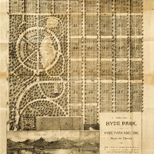
Attributed to Augustus Koch. Kansas City, Missouri: Inter-State Publishing Company, [1890]. Courtesy Dorothy Sloan-Rare Books Hyde Park is one of the most desirable neighborhoods of modern Austin. The legacy of its settlement and growth reminds one of the important role Hyde Park has played in the history of Austin. An early promotional map of Hyde Park reveals Shipe's layout of the new neighborhood. Drawn by noted map maker Augustus Koch, who prepared "bird's eye" maps of many Texas cities including Austin, Cuero and Victoria, it depicts a grid pattern of tree-lined streets. The west side of the development was dominated by a large park in the area bounded by present-day Guadalupe, West 38th, Avenue D and West 43rd streets. A "Railway Car Barn" for the Austin Rapid Transit Railway Co., the city's streetcar line, was shown near the southwest corner of Avenue D and Third (now 40th) Street. Two separate man-made bodies of water are labeled Gem Lake and Crystal Fountain. Frequently mentioned among the amenities Hyde Park offered, the lakes were drained in the mid-1890s to provide additional land for residential use as part of the effort to develop Hyde Park Addition No. 2.
All spots information
0 spots