Around the World in the Blink of an Eye, 1876
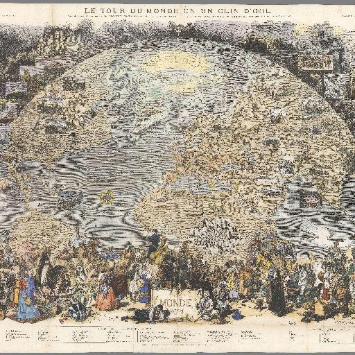
Pictorial view of the world. Originally issued uncolored, color was added later. Map is projected as a view from space and details the world roughly from the Equator to the North Pole and from California to India. Flora, fauna, historic events, cultural artifacts, and indigenous people are represented pictorially. The Sargasso Sea is illustrated in the middle of the Atlantic. Includes inset views illustrate places and moments of special interest including mirages in the Pacific, a ship burning at sea, Niagara Falls, Chicago, oil wells, gold mining, Hindu cremation, Chinese Junks, Tuareg warriors, an avalanche, etc. also includes lists of the nations and maritime flags. Shows sketches of some 79 individuals in 'traditional costumes'. To either side of the main view are flags of major nations, sailing ships, volcanoes, and other imagery. Include an ice free polar sea north of Greenland labeled 'Mer Libre?' No doubt this is a nod to hopes that a Northwest Passage might still exist. Union Pacific and Trans-Atlantic shipping lanes are noted. The achievements of various explorers are noted in both Africa and the Arctic.
All spots information
0 spots